
 |
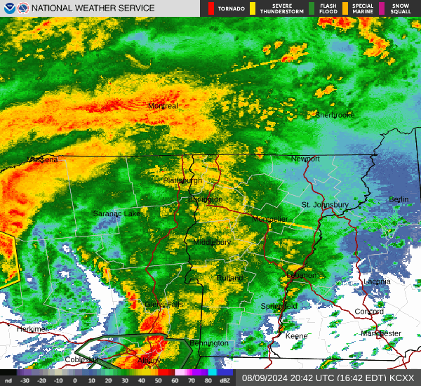
| After a relative lull, heavy rain was moving back into Vermont as of shortly before 5 p.m. The next few hours will be the stormiest of this whole former Tropical Storm Debby episode. UPDATE: 8:30 p.m. |
The rain is the heaviest it will be for the entire storm, or if it's not where you are, it soon will be. If we're going to get any flash flooding at all, it will between now (I'm writing this around 5 p.m.) and midnight.
New York State, as expected, is taking the brunt of this. Flash flood warnings and storm warnings are flying in large swaths of the Empire State as of 5 p.m. I noticed this morning and early afternoon's round of heavy rain also swamped the Montreal area with flooding, too.
One thing that probably helped tremendously was a relative lack of rain in Vermont between noon and 3 or 4 p.m.
Very few spots - except maybe far northwestern Vermont - got more than a tenth of an inch of rain in the early and mid afternoon.
This interlude lasted even longer in the flood-wracked Northeast Kingdom. After enduring another flood warning early today after a bout of overnight downpours. St. Johnsbury mustered just 0.05 inches of rain between 6 a.m. and 2 p.m.
The biggest threat with former Debby is from small brook, creek and stream flooding. That relatively calm interlude allowed those streams to settle down a bit, making them just slightly more able to handle the big onslaught of downpours now moving into the state.
That said, it still won't take all that much in the way of downpours to set off flash flooding, so some seems inevitable this evening. It still looks like it won't be as bad as July 11 or July 30, but I imagine there will be some damage out of this, if there isn't already. But it will be scattered damage, I'm sure.
The commute home this evening is quite a slog for many of us with reduced visibilities in areas of heavy rain, hydroplaning because of all the standing water and perhaps some washouts starting on steep dirt roads.
Thunderstorms and gusty winds mixed in surely won't help.
Winds have been light most of the day, but as expected, have been starting to ramp up from south to north, especially from the Green Mountains west. The wind abruptly started gusting to 40 mph in Bennington shortly before 3 p.m., and that's been working north since.
We can still expect wind gusts in the valleys of southwestern Vermont, the Champlain Valley and the western slopes of the Green Mountains to gust past 50 mph in some spots through the evening. They'll diminish south to north later this evening
The gusty winds hitting trees with shallow roots in basically mud is a recipe for some of them to topple over.
We're still looking the risk for severe thunderstorms and even a possible weak tornado or two for the next few hours. Some storms in southeastern Vermont were vaguely rotating as of mid-afternoon, but the rotation hadn't tightened up nearly enough yet for any tornadoes.
The main line of storms, which could produce spin ups, was far southwest Vermont as of 5 pm. and heading northeast. Don't know if there will be any spin-ups or not, but there's still a low chance it could happen.
This mess will all be over by midnight or shortly thereafter so we're almost out of it.
Stay safe this evening. It's not as bad a storm as those on July 11 and 30, but you want to stay on your toes regardless, and heed any weather warning that comes up for your area.
No comments:
Post a Comment