 |
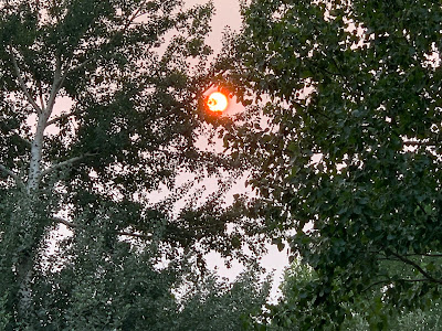
| A very orange looking sun, made that way by wildfire smoke in the air, hides behind our trees in St. Albans, Vermont last evening. Air quality will remain poor today because of all that smoke. |
The air quality index was in the moderate range early this morning, which for the numbers people is between 50 and 100 on the scale.
Once you get to 101, you start in with the "unhealthy of sensitive people," which is the point of the current air quality alert. That alert is in effect all day.
Rutland was getting close to that threshold this morning, with an air quality number at 82.
The air will probably worsen a bit through the day as it often does during daylight hours when we have attack of wildfire smoke, from wherever it's coming from. (For those who wonder, most of the smoke we're having now took a sort of circuitous route mostly from Alberta, Canada).
We'll have another day of brassy colored sunshine, dimmed by all the smoke in the atmosphere. It will be another sort of humid one. Showers and storms tended to be pretty few and far between yesterday, at least here in in Vermont. They will be even fewer in numbers today, with almost all of us having no rain.
This state of affair will help boost temperatures well into the 80s, with some upper 80s in the warm spots. Which leads us to the weekend.
WEEKEND SALVAGEABLE?
That sluggish storminess coming in from the Great Lakes is even more sluggish than first thought. At least here in Vermont, it's looking more and more likely most of us will escape with no rain. A few showers might develop, especially the further west you go. But many of us will stay dry. Those who do get any showers will only be in the rain for a short burst or short bursts.
Even Sunday now looks like it won't be a washout. Shower chances are better by then. But they will still be hit and miss.
The weekend will remain on the humid side, and probably still kind of smoky and hazy. Not hard core Chamber of Commerce weather, but probably good enough.
HINT OF AUTUMN
About this time of year, we start seeing cold fronts that suggest that fall is right around the corner. Right on cue, it looks like that slow, slow system from the Great Lakes will swing a cold front through Monday.
 |
| It's that time of year when you start to see tiny pockets of fall color amid all the summer greenery in Vermont. It will also briefly feel like autumn next week. |
I have a feeling the front will feel like more an autumnal one. Summer cold fronts usually give us bands and clusters of sometimes strong thunderstorms, but not usually a general soaking hours-long rain.
Once we get into autumn, cold fronts start to give us full rainy days. At this point, it's beginning to look like Monday will be that type of day.
It's a few days away, so things could still change, but Monday could well end up being a rainy "autumn" day.
It'll be cooler than it's been under the clouds and rain, but it will probably still feel a little humid, and temperatures should still make it into the 70s.
Behind the front on Tuesday, autumn will be in the air. Highs high not make it out of the 60s. If that happens in Burlington, it will be the coolest day since June 15.
I wouldn't exactly rush out to the garden and cover your stuff to ward off frost. It's only going to be vaguely cool. Not frigid. Upper 60s for highs aren't that weird for mid-August. Expected lows Tuesday night in the 45 to 55 degree range aren't odd either. The cool air will just seem out of whack because we've had such hot summers in recent years.
Besides, it really is still summer, for sure. After the cool weather next Tuesday into early Wednesday, we'll get back into a warming trend.

No comments:
Post a Comment