Showing posts with label Rutland. Show all posts

Monday, August 5, 2024

Debby Making Florida Landfall This Morning, East Coast Flood Nightmare This Week, Stormy Vermont With A Break

Satellite view of Hurricane Debby this morning just after
making landfall in northwest Florida. 
 Lots to talk about this morning with Hurricane Debby making landfall in Florida, a rough storm day in Vermont Sunday and very likely today as well, an eastern seaboard flood nightmare about to unfold, a break in the weather in Vermont followed by a possible new end of week threat.  

Phew! Like I said, busy. 

HURRICANE DEBBY

Debby was making landfall near Steinhatchie, Florida with a four to seven foot storm surge and sustained winds of 80 mph. So it's quite a blow.  Yes, it's a Category 1 hurricane, but they can still do a lot of damage along the coast. 

Especially since this is occurring just under a year after Category 3 Hurricane Idalia crashed ashore in the same region, maybe just 30 miles or so further up the coast. 

Details on damage so far are sketchy, as you'd imagine. The main trouble with Debby is going to be torrential rains and possibly historic flooding in parts of the Southeast. 

Debby is still expected to slow down to a crawl and linger in or near Georgia and South Carolina through much of this week. Its winds will quickly diminish once its inland today, but it will continue to dump tremendous downpours, as these things do. Debby might briefly head off the coast of Georgia into the Atlantic later this week, which would help sustain its strength. 

As much as six to 12 inches of rain could come down in northern Florida and southeastern Georgia within the next 24 hours. 

Continued torrents tomorrow could dump another half foot or more of rain in parts of Georgia and South Carolina. Parts of South Carolina can expect more than 20 inches of rain.

EAST COAST FLOODING

Areas of flooding, some possibly severe, are definitely possible in various areas of the Eastern Seaboard all week. Much of it depends on what Debby eventually does.  Since it will be meandering around, nobody is quite sure. 

For today, outside the Debby zone, pockets of flooding are possible in sections of Maine, New Hampshire and Vermont (more on that below). 

On Tuesday, the best chances of flooding, again, outside the "Debby zone" would in southern New England and in parts of the Mid-Atlantic states, especially in New Jersey and southeast Pennsylvania. 

 Wednesday and Thursday,  the flooding will focus once again on the "Debby zone" in the Carolinas. By Friday, the forecast is less certain, but flooding is possible (but not definite!)  anywhere in a zone from South Carolina to central New England. 

ROUGH VERMONT SUNDAY

In the humid air on Sunday afternoon and evening, storms left their mark on a few sections of Vermont, as if we didn't have enough damage. 

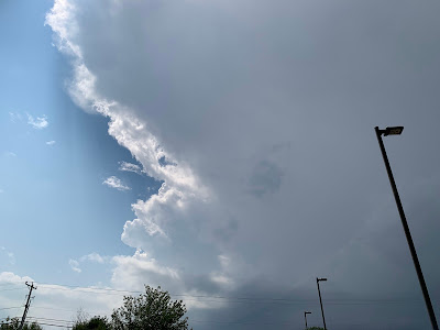
A thunderstorm looming over Colchester, Vermont 
Sunday, cut the sky in half, blue on the left, dark and
menacing on the right. The storm knocked some
trees down in South Hero, but weakened as
it moved further east into Colchester and Burlington.

It looks like Rutland and surrounding towns, and unfortunately hard hit St. Johnsbury were the main targets. 

Two rounds of severe storms swept Rutland County. Power was out through much of Rutland City, part of a  series of storm-related power failures to cut electricity to as many as 6,000 Vermont homes and businesses last night. 

Serious tree damage was reported in Rutland, Center Rutland, Castleton, Pittsford and Benson. Flooding  inundated some streets in Rutland, including at the busy intersection of Routes 4 and 7. 

Up in the Northeast Kingdom, renewed flash flooding wrecked some of the repairs to roads that were destroyed in last week's calamitous floods. Several roads in East Burke were washed out again, and new flood damage reports came out of St. Johnsbury. 

ROUGH VERMONT MONDAY

It seemed pretty clear and calm - and even a bit cooler than it's been in Vermont this morning. The calm weather is about to change once again. 

The cold front that will sweep the humid air once and for all means business. It's providing a risk of (ugh!!) new local flash floods across northern and central Vermont today. And severe storms across central and southern Vermont. 

Near the Canadian border,  it won't be sunny long enough this morning to destabilize the air much. Showers were already gathering in New York, and will increase by this afternoon as the cold front settles in.  So severe thunderstorms north of Route 2 seem pretty unlikely today. 

The rain could come down hard enough, even up by the Canadian border to set off some local flash floods. Again, not sure where, you can never tell in advance, but beware. 

There's a flash flood risk from Route 2 and points south as well, and that will be mixed with a second day of locally damaging thunderstorms. There could be a couple rounds of severe storms, too, much like what Rutland had to deal with Sunday. 

Everything will be hit and miss. Most of us will not get enough rain to trigger flash floods. It'll be hit and miss. So will the storms. Most places won't have storm damage, but a few will really get nailed by microbursts and strong winds. 

Just stay weather aware and heed any weather warnings you get today. 

VERMONT OUTLOOK

Yes, we will be cool and (mostly) dry Tuesday through Thursday. We'll enjoy the much cooler temperatures and much, much lower humidity. 

As for that risk from Debby's remnants at the end of the week or weekend, we just don't know whether or how it will affect Vermont. Some computer models bring torrential rain to at least parts of Vermont, other models are in the "meh" category. 

We'll just have to wait for updated forecasts on that. 


Wednesday, August 9, 2023

Addison County, Other Areas Of Vermont, Hard Hit By Storms, Might Not Qualify For FEMA Assistance

Torrential rains in Vermont that caused flooding after
the "Big One" on July 10-11 caused damage, but
that new damage might not qualify for FEMA assistance.
 In this hellishly wet, stormy, disastrous summer of '23 in Vermont, the long string of flash floods since the "Big One" on July 10-11 means that some people in the Green Mountain State might not get the help they need. 

All things considered, the storm damage Addison County from the big July 10-11 storm wasn't so bad - at least compared to severely hard hit counties like Washington and Lamoille. 

However, a series of storms since then have piled up the damage in Rutland and Addison counties since then.  The most recent ones causes serious problems around Middlebury on August 3, and around Rutland August 4. 

So far, though, Addison County has not qualified for a disaster declaration, 

The August 3 storm in Addison County was particularly serious.  Areas in and around Middlebury were inundated when a large, but isolated thunderstorm dumped up to 6.1 inches of rain in three hours. 

Several homes and businesses in and near Middlebury were damaged, and several roads, including Route 116 suffered serious damage. Even some buildings in downtown Middlebury and at Middlebury College suffered losses. 

 The town of Hancock is in the Green Mountains, in extreme eastern parts of the county,.  A number of roads washed out, homes and business suffered damage and people were stranded on the wrong side of gaping holes in roads and driveways where culverts used to be. 

Then on Friday, it was Rutland County's turn to suffer flood damage. Rutland City was especially hard hit. Homes on Clover, Granger and Spruce and other streets suffered damage. Other areas, like Stratton Road, suffered washouts.

Addison and Rutland counties, along with many other parts of Vermont suffered additional flood damage in a series of storms that started July 13.  It's unclear, though, whether the new damage around Rutland on August 4 will be included in the county's existing disaster declaration. 

Other areas of the state, like eastern Chittenden and Franklin counties, might not get help for storm damage in mid to late July. 

The problem is the Federal Emergency Management Agency reasonably enough insists on a firm start and end date to any particular disaster. Usually, the period of the disaster is limited to no more than a few days. 

This one in Vermont is like I mentioned in a previous post - the monster in a bad horror movie that keeps coming back even after everybody thought it had been killed. 

"Typically, FEMA will look at the storm system - one storm system - and that's the event. This is a little different. We have had multiple, multiple systems that have come in rapid fire after the initial event and created more damage. But everything has to come to an end in FEMA's eyes," Vermont Gov. Phil Scott said this week.

Which means that the stuff that happened since July 10-11 might not be included in FEMA's final disaster declaration.  A determination on all this is TBA. 

If Thursday and Friday's calamities cannot be lumped together with earlier floods in July, there might be another out.  If enough damage was sustained in western and southern Vermont, the late week storms could be declared a separate disaster.

Or perhaps FEMA will decide to include everything through August 4 as part of this one disaster. 

That's one reason why it's important for people to contact 211 to report flood damage, no matter when or where it hit this summer.  State officials said at least 6,000 people have contacted 211 to report damage. 

It's not like FEMA hasn't been involved, either. They are helping. As of this week, state officials said more than 4,500 people have applied to FEMA, and the agency has already distributed $11.6 million. 

The constant string of new storms has obviously stressed the thousands of Vermonters trying to recover from storm damage, and state resources. 

Vermont Public Safety Commissioner Jennifer Morrison said the state has conducted 216 rescues and 162 evacuations so far this year.  That compares to a quote, unquote normal year of six rescues and 30 or so evacuations.

There's no immediate forecasts of renewed flooding in the forecast, but we are going to continue to be harassed by rapid fire storm systems that will slow us down with showers on Thursday, later Saturday and occasionally next week. 


Saturday, August 5, 2023

Horror Movie Plot Summer Creates More Vermont Flood Chaos

Rutland,Vermont Alderman Michael Talbot posted this
photo of water rescues Friday on Clover Street in
Rutland. That region was hit hard by the latest of
many rounds of flash flooding in Vermont this summer.
This summer in Vermont is playing out like a very bad horror movie. 

You know the tired, cliched plot of these things: The monster keeps attacking, but finally it's vanquished and killed. Or so everybody thinks.

 Just when the movie's characters start to relax, the monster strikes again. 

So it's been in Vermont. Through July, the monster in the form of flash floods keeps striking.  It did its biggest attack on July 10 and 11, which really blew the special effects budget, so to speak.

Then the monster kept up its campaign, picking off victims one by one, taking out bridges, roads and buildings in one, town, then another, then another, then yet one more pretty much through July

A week ago, we thought the monster had finally been taken down. The weather pattern changed, and we didn't have to worry about these intense rains any more. 

Or so everybody thought. 

Thursday night, it was Middlebury's turn.  The attack in the form of torrential downpours was extreme and brutal.  Six inches of rain in that one spot in just three hours. An inch of it came in just 10 minutes. Middlebury was sunk.

RUTLAND HIT HARD

Unfortunately, things continued on Friday. The flood monster seemed to make Rutland and Springfield its next victims. 

Several Rutland streets were inundated. Swift water teams rescued at least 20 people from flooded houses, mostly around Clover Street near Route 7.  An emergency shelter for flood victims was being set up at Rutland High School, VTDigger reported.

Water blocked Route 7 just north of the intersection with Strongs Avenue, at Clover Street.  Route 7 is the main North/South highway in western Vermont  Parts of busy West Street were also closed. 

A large sink hole reportedly opened up near the Rutland Regional Medical Center, and Stratton Road nearby was closed. Several  basements along Church and Center streets in Rutland flooded. Houses were also surrounded by water on Spruce, Granger and some other areas of the city.  Rutland Mayor Mike Doenges declared a state of emergency as the flooding worsened Friday afternoon.

Heavy rain fell in the morning, then an intense afternoon storm positioned itself perfectly to create the most serious flooding possible in Rutland. The heaviest rain - three to as much as 4.37 inches - was centered over and just east of Rutland. That allowed water to rush down the hills near Mendon and Rutland Town into the city. 

To add insult to injury, hail and damaging winds were reported in Middletown Springs, Wallingford, West Rutland and Clarendon. 

In Springfield, torrential rains flooded roads and at least one business. 

Meanwhile, new details emerged about the seriousness in Thursday evening's flooding in Middlebury 

On Thursday, floodwater invaded the Middlebury Police Department, forcing them to temporarily relocate, the Addison Independent reported. 

Middlebury Police Chief Tom Hanley said as much as four inches of water was in the building, and dispatchers were taking emergency calls with their pant legs rolled up and barefoot to avoid the water. 

The Addison Independent also received reports of flood damage and Davis Family Library, the Axinn Center and Weybridge, Sunderland and Allen halls at Middlebury College.  Water also flooded parts of the Marble Works complex and at least one house on Court Street was severely damaged by the flooding. 

UP NEXT

Though it's not definite yet, as this map indicates
there's at least a slight chance of renewed
flooding in northern New England, including
Vermont on Tuesday. This forecast will
almost certainly change a little one 
way or another, however. 
Believe it or not, there could be even more trouble on the horizon, but of course we're not sure yet. That's the style of horror movies, right? Keep 'em in suspense.

 We are in for a nice, dry, sunny weekend, which will help temporarily ease the tension. 

However, a strong, dynamic storm for this time of year is taking shape in the Midwest and will head toward the Northeaster U.S. by early in the week. 

The storm will very likely cause a big outbreak of severe thunderstorms and possible tornadoes in the Midwest and East Coast between now and Monday. 

The sort of good news is Vermont appears to be a little too far north to share in the severe storms and tornadoes, The very bad news is we could be in for some more heavy rain, possibly enough to cause renewed flooding.  

Details are still slim on this potential storm, so we don't know for sure whether Vermont will see more flooding, never mind how bad any high water might be or where in the state it might set up. 

Even the long range forecasts are discouraging. Sure, they're often not accurate, but still, they do call for above normal temperatures and rainfall well into the middle of August. That's a recipe for humid weather with torrential downpours - if individual weather systems set up the wrong way for us. 

This Vermont Summer Movie of 2023 is way too long and needs some serious editing. 

Monday, May 16, 2022

Vermont Severe Storm Update: Pockets Of Flooding Now Biggest Concern

A few pockets of flooding wind and hail with today's 
turbulent weather in Vermont, but here in St. Albans, just
 little more welcome rain and a couple rumbles of thunder.
 Most of us did NOT receive severe thunderstorms in Vermont today, but a few places got it pretty good.

I give special kudos to the National Weather Service office in South Burlington. Before this all started today, they noted in their forecast discussion that several storms would form over the Green Mountains ahead of the main line of storms coming in from New York. 

Those Vermont storms would stabilize the air and limit the punch of the main squall line, except maybe in far southern Vermont. That's exactly what happened. 

The NWS/South Burlington also said some of those earlier storms would pack a punch and they did so. Several trees and power lines came down along Route 22A near Addison, and there were some reports of small hail, mostly about dime size.

In most places, though, the wind was manageable. I saw that Burlington got hit by a severe-warned storm, but the highest gust with it was a not-bad 36 mph. 

The big trouble spot this evening is, as usual around Rutland. That area seems so prone to torrential thunderstorms and it's happened again. 

I already told you about the gullywasher storm they had Saturday and the additional inch or so of rain Sunday morning in Rutland County. 

Late his afternoon, two thunderstorms ahead of the main line of storms merged over Rutland County, dumping torrential rain. Then the main band of storms was working through as I wrote this around 6p.m. and radar indicated the rain was especially heavy with this feature over Rutland County.

It's too soon to know how much flooding there is down in that neck of the woods. Could be minor, could be locally nasty.  Don't know yet. I hope to have some sort of update tomorrow morning. 

A flood warning was issued, followed up at 6 p.m. or so by a flash flood warning specifically for Rutland, Proctor, West Rutland, Pittsford, Ira, Castleton, Hubbardton, Poultney and Florence.  

I also noticed on radar at 6:15 p.m. an area of especially torrential rain moving up from Addison County into eastern Chittenden County.  That area has received little rain is a little better equipped to deal with the runoff. But if this holds together and makes it to areas north and west of Stowe, that could get dicey due to earlier heavy rain there. 

Most of the rest of us are getting rumbles of thunder and some very welcome rain, with a few heavier downpours mixed in just for emphasis

Although the severe thunderstorm watch was still in effect as of 6:15 p.m., I think the risk of damaging winds and large hail is not zero, but pretty low at this point. I noticed a new severe thunderstorm warning did pop up for the area around Montpelier just now. 

Beyond that, flooding is the only real concern I have. 

The outcome is uncertain on the flooding, so I'll update tomorrow.