 |
| Skies grew ominous over the Champlain Valley of Vermont late Wednesday afternoon. |
All morning and most of the afternoon, a band of rain with the front slowly worked eastward across New York toward Vermont.
There was nothing remarkable about this area of rain. When it got to my area in far northwestern Vermont it only dropped a third of an inch of rain over several hours.
But as the front got just a little further south and east, I watched as things got interesting. From where I was in South Burlington late Wednesday afternoon, I saw the clouds to the west and southwest turn very dark and very interesting. Suddenly, the boring radar images showed torrential rains blossoming. Alerts started buzzing out of the National Weather Service office in South Burlington.
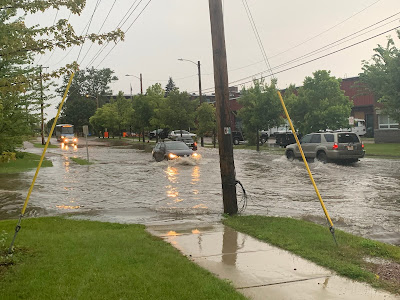
The storm suddenly turned severe, tossing trees down in Shelburne, Hinesburg and a few other places in Chittenden County. Blinding rain quickly flooded streets. Hail pinged off my truck hood and windshield.
 |
| The approaching storm grew more intense as it approached the Burlington area...... |
That didn't seem to materialize until very late in the afternoon, when BOOM - that bit of atmospheric juice arrived to quickly set off that thunderstorm.
Basically, Mother Nature threw gasoline on a smoldering fire.
Once that atmospheric energy was added to the mix, a long line of strong thunderstorms eventually stretched from Vermont's Northeast Kingdom all the way down to the Catskill Mountains in southern New York.
Severe storm warnings and flood advisories crackled up and down the state and into southwestern New England as that line slowly pushed east. Tree damage was reported as far south as Connecticut.
In the grand scheme of things, this was nowhere near an extreme event. There was damage, but it certainly wasn't a full blown disaster. It was dramatic, especially when a spectacular post-storm sunset entered the picture, but it wasn't terrifying. Just kinda cool, if you ask me.
 |
| ...unleashing torrential rains... |
Microbursts are bad, as they consist of a mad rush of powerful winds that race down vertically from the sky and can cause a lot of tree and structural damage.
Winds from microbursts then spread out, and as they do so, eventually weaken. Which meant the full force of Wednesday's microburst missed where most people live.
Though I know a number of trees got toppled by the wind on Harbor Road out on Shelburne Point, so they got some of it.
The cold front that caused Wednesday's excitement is now heading into eastern New England. It's temporarily stalling out, and could cause a nasty flood situation in Downeast Maine today. A few inches of rain could fall there during the day today.
 |
| ...and street flooding in Burlington, Vermont.... |
I also want to take the opportunity to give a huge Raspberry to the New York Post. There were concerns about renewed flash flooding and possible tornadoes in southern New York and New Jersey Wednesday. This just days after the devastating floods last week.
The Post tried to claim the predicted rough weather there was due to Hurricane Larry.
But Larry was 800 miles off the coast and was having zero impact on the weather around New York City, aside from rip currents and swells at the beaches.
But adding "Larry" would bring extra social media clicks and revenue to the New York Post. Never mind that the the predicted New Jersey/New York weather trouble would be entirely caused by the same cold front that gave Vermont its thunderstorms.
 |
| And the storm department, leaving us with a spectacular sunset. |
Speaking of Larry, it's still expected to sideswipe Bermuda and then kick the southeast corner of Labrador late Friday or early Saturday before heading to its cold death near Greenland Sunday.
Tropical Storm Mindy abruptly spun up south of the Florida Panhandle Wednesday, spinning off a few local flash floods and tornado alerts before coming ashore and falling apart. It could cause some flooding in Georgia and South Carolina today, but overall, not a big storm there.
Another tropical system might affect the western Gulf of Mexico next week, and the National Hurricane Center will watch a disturbance come off the western African coast. That might spin up a hurricane next week, but it will be way out to sea. If that system does grow, it won't affect any major land areas for many days, if at all.

No comments:
Post a Comment