Showing posts with label photography. Show all posts

Sunday, June 28, 2026

Fascinating Time Lapse Of A Severe, Rotating Storm Over Rutland County, Vermont

Screen grab from a Jeffery Smith-created time lapse of a
rotating mini supercell thunderstorm last Friday. This is
looking north from West Rutland, Vermont. The lower
cloud over the slight ridge on the right side of the 
photo appears to be a possible wall cloud, which
can be a precursor ro a tornado, No tornadoes
occurred with this storm. 
That powerful thunderstorm last Friday that rolled through central Vermont and southern New Hampshire was unique. And we have video proof of just how cool that storm was. 

It developed near Ticonderoga, New York and by the time it traveled the short distance into northern and central Rutland County, it was rotating and spewing damaging winds and hail. 

The storm passed just north of West Rutland before thrashing Proctor and the north and east sides of Rutland with winds that tossed down trees and power lines. 

In West Rutland, photographer Jeffrey Smith, who does a lot of fantastic drone and surface shots in and around the town, captured an absolutely fascinating time lapse of the storm as it passed just to the north of West Rutland and slammed into Proctor. 

Here's the video. A description of what's going on is below.


The time lapse video is over West Rutland, looking north toward Hanley Mountain. The center of the storm is right behind the mountain. 

The National Weather Service in South Burlington had issued a severe thunderstorm warning pretty much as it entered Vermont around the town of Benson. The severe storm warning was still in effect when this video was shot. 

Meteorologists had noticed broad rotation in the storm by the time it reached its position seen in the video. But correctly, in my opinion, they did not issue a tornado warning as the storm did not appear to be preparing to form one, 

However, the video shows the storm might have come close to creating a brief one. 

Despite the extremely high quality of Smith's video, it's hard to tell exactly what some aspects of the storm meant. 

As you can see in the time lapse, the storm was clearly rotating, left to right. Near the beginning of the photo, it seems like a spot with lower clouds might be spinning, but it quickly gets disrupted, probably an effect from Hanley Mountain .

Especially when you see a gush of rain start to come over the mountain, a lower cloud becomes much more visible on the right side of the screen. Toward the end of the video, that cloud lowers further, becomes more round shaped and clearly starts to spin. 

That to me really looks like a wall cloud.  If a real meteorologist wants to weigh in and correct me, please do! If a tornado were to form, a wall cloud is where it would originate 

When my alleged wall cloud started spinning, that's when radar would have seen the tightening spin, and the National Weather Service would have been tempted to issue a tornado warning. But the spin was probably between scans and was very brief.

The video cuts off, but it looks like that gush of wind and rain. would have destroyed the spin on the cloud, ensuring that this supercell remained just a severe storm. Many wall clouds do not produce tornadoes, and here was an example of that. 

Still, with this storm, Vermont could have had its fourth tornado of the year. But, thankfully, it didn't happen. 

My alleged wall cloud was over the western edge of Proctor when the film was taken. There was tree damage in Proctor, but that was due to straight line winds. 

Also, notice the trees at the very bottom of the film. You can see the wind is blowing toward the storm. That supercell was ingesting warm, humid air to keep it alive. 

The storm went on to produce straight line wind damage on the north and east sides of Rutland and in Mendon. The storm appears to weaken a bit after crossing the green mountains. But it regrouped, and continued on as a spinning supercell through central and southern New Hampshire, leaving a trail of wind and hail damage behind.  

Again, Many thanks to Jeffrey Smith for permission to use the video!


Friday, August 29, 2025

My Favorite Vermont Summer Storm Photos, 2025

A thunderstorm begins to loom over Lake Champlain
boaters near Alburgh, Vermont on May 16.
 Overall, this wasn't a big year for summer storms here in Vermont. 

They didn't happen all that frequently and there were only a couple of really damaging outbreaks, one one May 17, the other on July 10.   

As you'll see by the photos, July 10 was my favorite storm day of 2025. The only thing I hated was the resulting flash flood in the Northeast Kingdom.

I love to go out and storm chase. That might seem a little silly in Vermont, given our relative lack of dramatic storms. 

It also didn't help that wildfire smoke sometimes obscured some of the best summertime storm clouds this year. 

It also didn't help that the August drought meant there were precious few thunderstorms to photograph.

Being in Vermont, it's highly unlikely I'll ever get much in the way of striking images that show tornadoes, gorilla hail or high speed winds raking the landscape.  

Georgia, Vermont, June 18
When I hunt for Vermont summer storms, I'm just looking for pretty pictures. An unstable summer sky in the Green Mountains is probably the prettiest you can get. 

Vermont thunderstorms are usually gorgeous, no matter how dark the clouds. 

Sure, they are dangerous sometimes. But you can't escape their allure. 

 I sometimes make YouTube videos of them, too, complete with those pretty clouds, thunder, rain, and sometimes wind. 

 Some examples of this year's videos are here, here, here and here. 

I think the summer thunderstorm season is over. Though sometimes we can get September surprises, so I'll keep my eyes out. 

All the photos in this post had no or zero editing. 

Scroll down through this post and let me know which photos in this post you like the most. 

Charlotte, Vermont, June 24

Jeffersonville, Vermont, July 10

St. Albans, Vermont, July 10

St. Albans, Vermont, July 10

Georgia, Vermont, July 13

Georgia, Vermont, July 13

 Swanton, Vermont, July 17

St. Albans, Vermont, August 29

Saturday, May 11, 2024

Northern Lights Delights Millions Of People, Including Southerners, Vermonters

 Wow! What a show!

I was able to catch this image over St. Albans, Vermont
with an old iPhone5.
Much of Planet Earth was treated to a spectacular show of aurora last night, as the most intense geomagnetic storm from the sun in decades caused a massive display in the skies. If you went outside in Vermont last evening as I did, you surely saw a treat. 

The aurora is normally a creature of the far north. But Friday night, denizens of such Arctic outposts as Tybee Island, Georgia, San Antonio, Texas, Orlando, Florida and Nassau, The Bahamas found themselves enjoying the nighttime display. 

Take a look at your social media. It's FULL of photos this morning of the aurora.  If you really want some great Vermont images, check out photographers Adam Silverman, Stephen Mease and Brian Drourr

There are surely other Vermont photographers that I'm inadvertently skipping that also have amazing images.

Here in Vermont, it was the second extreme and breathtaking event in the skies within about a month, and on both occasions the weather cooperated. That's something rare in this cloudy state.

Back on April 8, northern Vermont was in the path of a total solar eclipse. High clouds that moved in just prior to the eclipse did nothing to block the spectacle, but did add some color and texture to what was already a breathtaking event.   

Old iPhone5 capture of the show last night over 
St. Albans, Vermont. 

Last night, skies partially cleared in Vermont, especially in the north, just before sunset. Like during the eclipse, the remaining clouds added texture to the curtains of green and red dancing in the sky. 

The aurora was so far south that it seemed to be originating right overhead. For a time here in St Albans, there was a dark circle directly overhead with streamers and sheets of green and red light emanating from it in every direction. 

Incredibly, the aurora covered the whole sky from northern to southern horizon.  That's only the second time in my long life I've seen anything like that. (The first time was during an outdoor birthday party my sister threw for me on September 7, 2002. Nice gift!)

Last night, the color changed constantly and so did the quality of the show. Sometimes it was just a general green or red glow in the sky. Other times, brilliant streaks lit up the night. 

At one point a shooting star zoomed through the spectacle, adding just that much more to the show. At another point, it got spooky. Most of the sky glowed a blood red, which reflected on the landscape surrounding me, making it seem like everything was red.

At one point last night, the sky over St. Albans turned
a spooky blood red. 
Since the aurora wasn't limited to a narrow path like the eclipse was, we had no stampede to Vermont to witness the show. Still, popular viewing spots got busy. 

 The Route 2 causeway between Milton and South Hero over Lake Champlain was reportedly jammed with hundreds of people, as that location offers a spectacular, clear view to the north. And in the case of what happened last  night, to the south, too.

The strength of the geomagnetic storm that caused all this could have created disruptions, such as power failures, internet outages and long lasting GPS short circuits. So far, though, I've seen no reports of any major issues. 

The only casualty I could find was our Jackson the Weather Dog here in St. Albans. He was a bit traumatized and confused because Jeff and I turned off all the exterior lights on our house and stood in the driveway, staring at the sky. 

The geomagnetic storm is continuing, so much of the planet might see another aurora tonight. It probably won't be as widespread as last night. 

Here in Vermont, we'd have a shot of seeing something somewhat less spectacular than last night, but still worth staying up for. However, the forecast is cloudier than it was last night. 

This has been quite a year for Green Mountain State skywatchers. Next up is not space weather, but regular weather. 

We're heading into thunderstorm season, which to me creates the most beautiful and interesting clouds possible. No thunderstorm outbreaks are in the immediate forecast, though it will be showery off and on today through at least Wednesday. 


Sunday, April 7, 2024

Vermont Eclipse Forecast: High Clouds, But Still A Great Show

High, thin clouds are expected to appear in the skies over
much of Vermont by the time the eclipse arrives Monday,
but the clouds will be thin enough so that we
should still enjoy a great show. 
 We have another instance coming up in which Vermont is wonderful, but not perfect.

That would be the eclipse.   

Tomorrow is the big day, so the forecasts are almost locked in. There could still be some changes, but meteorologists seem fairly confident about what's going to happen Monday 

HIGH CLOUDS 

The way the forecast for Monday looks now, a bluebird clear blue morning will be invaded by high, thin clouds by the time the eclipse rolls around in the afternoon. 

The great news is this will be no means be a thick overcast.  To an extent, you'll be able to see through the clouds and take in a lot of what's going on.  We're still in for a great show. 

You'll most likely still see the moon takes bites out of the sun as if it's eating a vanilla wafer, then cover the sun entirely. (You will be watching all this with your special eclipse glasses on, of course). The changing, fading light as the eclipse draws close will still be stunning. 

Maybe the clouds will enhance the experience. It will be interesting to see how the thin clouds look during the eclipse and the moment just before and after. There might be some interesting colors or shadows or effects because of those clouds. 

The high clouds, of course are making things not perfect. Especially for photographers and people who want an unobstructed view of it all. The eclipse will result in fantastic photographs, of course. But a crystal clear sight is probably not in the cards, for those who wanted pristine shots of the edges of the sun peeking from behind the moon. 

The thinnest, most scattered clouds along the eclipse route in Vermont will be in the Northeast Kingdom. 

Two or three days ago, the high clouds were initially forecast to only make it as far east as around Buffalo, New York. But each computer model run had the band of high clouds moving faster. So now, unless the computer models reverse themselves, we'll see the cirrus clouds overhead in the Green Mountain State. 

This is so much better than climatology would have it, though. This is a terribly cloudy time of year in Vermont. It's usually stormy You might remember the news stories a few weeks ago saying we had an 80 percent chance of overcast during the eclipse. 

Notice how most of us didn't see the sun this past Wednesday through Saturday. This coming week, Wednesday through at least Saturday, also looks like it will be overcast and dismal. 

The clouds this time of year are often thick and low. Can you imagine how disappointing the eclipse would have been had it hit during the big snowstorm Thursday, or amid the damp overcast of Friday?

Fingers crossed that the high clouds won't thicken up, but it appears we might be beating the odds. Despite the thin clouds, Vermont is catching a big break, timed well for the eclipse.

Temperatures will be comfortable for viewers, too.  We'll get well into the 50s just prior to the eclipse, though temperatures of course will drop noticeably during the event as the sun disappears.

NO HIKING!

Although we'll have pretty good viewing weather for the eclipse, there are certain things that are a really, really bad idea during the eclipse.  

For instance, if you know anybody who thinks it would be fun to hike to a mountain summit to view the eclipse, strongly tell them to think again. You're not supposed to use hiking trails this time of year anyway because it's mud season and you'll damage the trails. 

Even though the weather forecast looks good, we'll also have the worst possible weather Monday to hit the hiking trails. We just had a lot of snow and it will be melting rapidly Monday. The cold, running water and deep mud on the trails will be awful. There will still be a ton of snow in the highest elevations. (There's still six or seven feet of it atop Mount Mansfield). 

There's tons of ice to slip and fall on, too.

If you get stuck in the mountains, cell service will be spotty at best if you need to call for help. Cell service will be especially strained due to the heavy use expected.

Rescue crews will be stretched thin, too. If you get into trouble up in the mountains, you might not get help until well into the night. By then, temperatures will be in the 20s up there.

BOATING A BAD IDEA

Although winds will be light and waves pretty minimal, it's still a bad idea to take a boat or kayak or anything like that out onto Lake Champlain or other bodies of water for the eclipse. Water temperatures are still in the 30s in most areas. If you fall in, you won't last long. 

If you want a lake in your eclipse view, pick a spot on the shore with a nice west and south facing view.  Burlington's Waterfront and St. Albans Bay Town Park are great spots for eclipse lake views, but expect crowds and traffic. Note there will be some street closures in Burlington and other communities. 

STICK TO THE PAVEMENT

With all the melting snow and thawing frost and heavy precipitation we had all winter, back roads and dirt roads will be an absolute mess. I know some of you might want a spectacular, rural view of the eclipse. Most dirt roads will be mud bogs, though. It'll be really easy to get stuck. And really hard to obtain help getting pulled out. Definitely best to stay on the paved roads. 

Don't believe the GPS in your car. It often lies and can send you to a remote dirt road, often not maintained well.  Thursday's snow has long since been removed from paved roads and they will all be in great shape Monday, aside from the occasional pot hole and frost heave.

PICK YOUR SPOT

You'll want to plan ahead for this one. 

Today might be a good day to scout out a place where you'd like to view the eclipse.  Maybe go out between 2 and 4 p.m. this afternoon to judge spots where the eclipse will look good to you.  Unobstructed west and south views are best. 

Remember, traffic will be thick Monday, so allow plenty of time to get to your viewing spot. It'll be a bummer to be stuck on the roads when the eclipse hits, so be where you want to be ahead of time. Make sure you have a tank full of gas. And snacks and beverages. You might be stuck in traffic after it all ends. 

DON'T SWEAT IT

This is a once in a lifetime opportunity, so stay positive. Don't road rage in the traffic. Don't elbow people away to get a view. Don't tromp across private property. There's plenty of public areas to watch the spectacle. Don't be a Karen. There will be no eclipse manager to entertain your bullcrap.

Just enjoy the experience and live in the moment during the eclipse. 

It will be quite a moment. 

Wednesday, December 28, 2022

Delaware Winter Beach Sunrises Are The Best!

Arctic sea smoke is visible on the ocean just after dawn
December 24, 2022, Bethany Beach, Delaware.
 I'm on vacation in Bethany Beach, Delaware, sharing a big oceanfront home with relatives and friends. 

Among the many perks of this arrangement is winter sunrises over the ocean. 

I'm an early riser, and the sun comes up late just a week after the winter solstice, so I get a great view of the dawn breaking over the ocean.  It's always different, and always sublime. 

The videos, seen below at the bottom of this post, don't do it justice, but are certainly worth watching. (The only problem with them is the sound quality is iffy, oh well).

The videos are still relaxing, so if you want a moment of relaxation, watch 'em. 

The first video was taken Christmas Eve morning, when the East Coast was still in the throes of that Arctic outbreak and aftereffects of that big bomb cyclone.

Sunrise, Bethany Beach, Delaware, December 27, 2022
It was quite cold for this neck of the woods, coastal southern Delaware. Temperatures were in the upper single numbers at dawn. Frigid by Delaware standards, but kind of average "yawn" winter weather for this Vermonter. 

Anyway, as the sun rose that morning, the ocean simmered with Arctic sea smoke, sort of giving me a Lake Superior lakefront in Duluth vibe. 

I enjoyed the sunrises in subsequent mornings, of course. Yesterday, December 27, was much warmer (Upper 20s!) so it was even easier to enjoy the early morning dawn.

There were a few more clouds in the sky than on previous mornings, which made the whole thing more interesting. A sharp red line appeared on the horizon well before sunrise. Then the clouds gradually filled with pastel colors.  Just such an awesome sight.

I'm here for two more mornings.We'll see what those dawns bring!

First video, on December 24. Click on this link if you don't see the image of the video, or click on image below.  And underneath that is the second video.


Next video is a very pastel dawn on December 27 in Bethany Beach.  Click on this link to view or on image below:


Sunday, October 9, 2022

"Snoliage" Is the Holy Grail Of Vermont Leaf Peeping, And It Happened Saturday

Snoliage atop Mount Mansfield as viewed from 
Irish Settlement Road in Underhill, Vermont on Saturday.
The white sheep dotting the green field in the
foreground is a nice touch. 
 I'm sure everybody loves snoliage, even if they don't quite know what it is. 

Snoliage is when beautiful autumn leaves combine with snow to create especially beautiful scenery. Here in Vermont, it doesn't happen every year, but it does occur often enough. 

On relatively rare occasions,  the snow extends down to valleys during peak foliage season, and that's when it really becomes awesome. Most times, though, the snow is limited to the mountains, but it still comes off as stunningly beautiful.

It's especially gorgeous when the skies clear, so you can the deep blue of a chilly autumn sky, the warm hues of orange and yellow and red trees, with snow capped mountains with a few wispy clouds around the peaks being the cherry on top. 

That's what happened in parts of Vermont on Saturday. 

Snoliage, with a white Mount Mansfield summit, and
brightly colored trees, as seen from a field off of 
Pleasant Valley Road in Underhill, Vermont Saturday.
I intercepted some snoliage yesterday, mostly in Underhill, near Mount Mansfield. The photo of it I posted on social media yesterday was a hit, so I reprised that photo as the first image you see in this post. 

Of course, I took other photos as well. Who could resist?  I put some of them in this post as well.  Click on the images to make them bigger and easier to see. 

I also put together a quick raw video of it too, which you can see at the bottom of this post. 

The snoliage around Mount Mansfield on Saturday not surprisingly attracted quite a crowd. 

The parking lot at the famous sledding hill on Pleasant Valley Road was often nearly full, as was a patch of gravel close to the Underhill town offices. 

Back roads like Irish Settlement Road were also unusually busy. 

A snow and rime ice topped Mount Mansfield with peak
fall foliage in the foreground Saturday in 
Underhill, Vermont. 
The best snoliage views often don't last long, and Saturday's were no exception. The beautiful blue skies only lasted from about noon to 4 p.m. and then clouds returned.

 Most of the thin trace of snow and rime ice atop Mount Mansfield has probably melted by now. 

There might be more chances for snoliage over the next week or two, but the beauty might not be as great as Saturday's.  Foliage will go past peak.  But, I'm happy to share a few images captured Saturday.

I'm so glad I decided to veer away from the responsibilities of work and just enjoy an autumn Vermont afternoon for a change.  

It's also testimony to the fact that it's much more fun to avoid the peak fall foliage season traffic jams in the usual tourist hubs and instead try some back roads. They're much more fun. 

Also, the video is below. If you don't see the image for it, click on this link to view. If you do see the image, click on it to watch on YouTube. 


Thursday, June 30, 2022

Picturesque "Goldilocks" Thunderstorms Caused No Real Trouble Wednesday, Weather To Remain OK

A non-severe thunderstorm with a shelf cloud
along its leading edge looking northwestward from 
St. Albans late Wednesday afternoon. 
I love summer thunderstorms, and we haven't had all that many so far this year.

So Wednesday afternoon turned into an unexpected delight as a weak cold front caused a bit more excitement than early forecasts indicated.  

Thunderstorms erupted ahead and along the cold front in Vermont Wednesday afternoon and evening, creating some "safe" drama.

I keep remarking about our current Goldilocks summer, not too hot, not too cold. We even had  Goldilocks thunderstorms yesterday. Fun to look at, but not particularly dangerous. 

There's a couple photos of the storms in this post, and be sure to watch the video I shot at the bottom of this post. 

There had been a low risk that  a few of Wednesday's storms could have briefly strong, damaging winds. However, I've seen no reports of any storm damage. Vermont Outage Map last evening had 4,500 Vermont customers without power. I'm guessing that had to do with lightning strikes, or an isolated falling tree on a power line, probably in northeastern Vermont where one storm got a little rambunctious.

Radar images showed some storms briefly getting strong, but they would then quickly weaken. So, there might have been isolated pockets of fallen branches that either nobody saw or nobody reported. I drove through a fairly strong storm in Sheldon. My guess is peak gusts with that storm were a reasonable 35 mph or so.

I noted just one fallen small, roughly foot 18 long branch in the middle of Route 105 and another, rotten, ten foot long branch from a very dead tree on the side of the road. That branch would have probably fallen on a sunny, breezy day so it doesn't count. 

Turbulent skies over Sheldon, Vermont late Wednesday
afternoon as thunderstorms passed through the area.
The storms north and west of St Albans did have decent shelf clouds, though. Shelf clouds are these sort of low hanging, kind of wedge shape clouds on the front end of many thunderstorms. 

They often look incredibly ominous and scary, but the clouds themselves aren't a danger. People sometimes confuse them with incipient tornadoes but they definitely are not. 

 A shelf cloud often, but not always means the storm coming is severe, so it's best to seek shelter when you see one. Wednesday's shelf clouds were not attached to anything too dangerous, as we noted.

Rainfall wasn't even that impressive with most of the storms. Mostly because the air wasn't particularly humid, so the storms didn't have much moisture to work with. Montpelier reported just 0.17 inches of rain. Burlington had 0.05 inches. A brief downpour here in St. Albans yielded just a tenth of an inch. 

We're heading into a holiday weekend, and the weather looks pretty favorable. The Goldilocks summer continues. 

Today will be gorgeous, although some clouds from a dying complex of thunderstorms over the northern Great Lakes might throw some afternoon clouds our way.

Friday looks briefly hot, before another cold front sweeps through with showers Friday night and Saturday morning. Sunday and Monday look at this point at least partly sunny at this point, with temperatures a wee bit cooler than you'd expect on the Fourth of July. (Highs in the 70s, lows in the 50s) .

Here's some video I shot Wednesday of the non-violent but nice thunderstorms near St. Albans and Sheldon, Vermont. If you don't see the image of the video to hit, click on this link to view: 


Monday, February 7, 2022

A Gorgeous, Windy Winter Day On The Lake. In Photos and Videos

Strong winds and blowing snow on the Lake Champlain
causeway in South Hero Sunday afternoon.
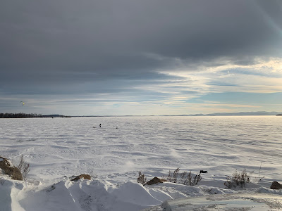
Sunday afternoon, Lake Champlain: A couple days after that big storm of powdery snow dumped more than a foot of snow on the icy surface of the lake, the wind picked up.  

It always does in the winter on and near Lake Champlain.  Winds gusting to 40 mph or so propelled that fallen snow into South Hero and other south facing shores of the lake. 

This all happened under a gorgeous, almost otherworldly sky.  Plus, some kite skiers took advantage of the very blustery weather to spend the afternoon skipping along the lake surface towed by their kites flying in the wind.

Of course, I had to take photos and videos, and the results are on this page. Scroll down to look at the pbotos, and at the very bottom is the video.  The video really shows what it's like to be on the Lake Champlain islands in the middle of winter. 

Click on the photos to make them bigger and easier to see.

Kite skiers prepare their rigs under a rather otherworldly
sky in South Hero, Vermont Sunday. 
 

Kite skier on Lake Champlain in South Hero, Vermont Sunday.

Lake Champlain in South Hero, Vermont Sunday. This 
area can look like a lonely Arctic trek this time of year. 

Clouds in the sky sort of echo the snowdrifts on ice-covered
Lake Champlain in South Hero on Sunday.


Now onto the video. Lots of blowing snow, and an expansive lake, making things look both bleak and beautiful.  If you don't see it displayed below, click on this hyperlink.  To view the video most clearly, click the red arrow on the below image, then the YouTube logo. 


Thursday, September 9, 2021

Wednesday Storms Start Late, But Impress; Ma Nature Throws Gas On Fire

Skies grew ominous over the Champlain Valley of Vermont
late Wednesday afternoon. 
As a weather geek, it was fun to watch how storms belatedly blossomed in Vermont Wednesday as a cold front slowly crept toward and into the Green Mountain State.  

All morning and most of the afternoon, a band of rain with the front slowly worked eastward across New York toward Vermont. 

 There was nothing remarkable about this area of rain.  When it got to my area in far northwestern Vermont it only dropped a third of an inch of rain over several hours.

But as the front got just a little further south and east, I watched as things got interesting. From where I was in South Burlington late Wednesday afternoon, I saw the clouds to the west and southwest turn very dark and very interesting. Suddenly, the boring radar images showed torrential rains blossoming.  Alerts started buzzing out of the National Weather Service office in South Burlington.

The storm suddenly turned severe, tossing trees down in Shelburne, Hinesburg and a few other places in Chittenden County. Blinding rain quickly flooded streets. Hail pinged off my truck hood and windshield. 

The approaching storm grew more intense as it approached
the Burlington area......
Where did THAT come from? Forecasters has been watching all day, waiting for some expected extra lift in the atmosphere from a disturbance that would be riding northeastward along the front. 

 That didn't seem to materialize until very late in the afternoon, when BOOM - that bit of atmospheric juice arrived to quickly set off that thunderstorm.

Basically, Mother Nature threw gasoline on a smoldering fire.  

Once that atmospheric energy was added to the mix, a long line of strong thunderstorms eventually stretched from Vermont's Northeast Kingdom all the way down to the Catskill Mountains in southern New York.  

Severe storm warnings and flood advisories crackled up and down the state and into southwestern New England as that line slowly pushed east. Tree damage was reported as far south as Connecticut.

In the grand scheme of things, this was nowhere near an extreme event.  There was damage, but it certainly wasn't a full blown disaster. It was dramatic, especially when a spectacular post-storm sunset entered the picture, but it wasn't terrifying. Just kinda cool, if you ask me. 

...unleashing torrential rains...


Plus there was a lucky break. The storm in Chittenden County produced a microburst over Lake Champlain. 

Microbursts are bad, as they consist of a mad rush of powerful winds that race down vertically from the sky and can cause a lot of tree and structural damage.

Winds from microbursts then spread out, and as they do so, eventually weaken. Which meant the full force of Wednesday's microburst missed where most people live. 

Though I know a number of trees got toppled by the wind on Harbor Road out on Shelburne Point, so they got some of it. 

The cold front that caused Wednesday's excitement is now heading into eastern New England.  It's temporarily stalling out, and could cause a nasty flood situation in Downeast Maine today. A few inches of rain could fall there during the day today. 

...and street flooding in Burlington, Vermont....
Back here in Vermont,  storminess in the upper levels of the atmosphere will touch off scattered showers today and tonight, but they won't have nearly the amount of drama as Wednesday evening's weather did.

I also want to take the opportunity to give a huge Raspberry to the New York Post.  There were concerns about renewed flash flooding and possible tornadoes in southern New York and New Jersey Wednesday. This just days after the devastating floods last week.

The Post tried to claim the predicted rough weather there was due to Hurricane Larry.  

But Larry was 800 miles off the coast and was having zero impact on the weather around New York City, aside from rip currents and swells at the beaches.  

But adding "Larry" would bring extra social media clicks and revenue to the New York Post.  Never mind that the the predicted New Jersey/New York weather trouble would be entirely caused by the same cold front that gave Vermont its thunderstorms.  

And the storm department, leaving us with a
spectacular sunset.
In any event, there ended up being little storm damage in New Jersey and New York last evening.

Speaking of Larry, it's still expected to sideswipe Bermuda and then kick the southeast corner of Labrador late Friday or early Saturday before heading to its cold death near Greenland Sunday.

Tropical Storm Mindy abruptly spun up south of the Florida Panhandle Wednesday, spinning off a few local flash floods and tornado alerts before coming ashore and falling apart.  It could cause some flooding in Georgia and South Carolina today, but overall, not a big storm there.  

Another tropical system might affect the western Gulf of Mexico next week, and the National Hurricane Center will watch a disturbance come off the western African coast. That might spin up a hurricane next week, but it will be way out to sea.  If that system does grow, it won't affect any major land areas for many days, if at all.