Showing posts with label eclipse. Show all posts

Tuesday, April 8, 2025

One Year Anniversary Of Great Vermont Eclipse Of 2024: Still Basking In The Afterglow

The view from my St. Albans, Vermont house during
the total eclipse of the sun, April 8, 2024,
 Today is the first anniversary of the Great American Eclipse of 2024.

I'm still in awe of what I saw, as lucky for me, the center of totality passed right over my St. Albans, Vermont home.

 My husband Jeff and I parked ourselves in chairs on our back deck, with a perfect view to the southwest, where the sun was that day. 

Vermont got really lucky on April 8, 2024.   The weather is seldom nice in the Green Mountain State this time of year.  

I mean, look at today. There's lots of clouds, it's colder than hell, and snow showers keep dusting the early spring landscape. 

There had been an 80 percent chance that that eclipse day would be overcast, based on past weather records. 

Instead, the weather was absolutely, improbably perfect on April 8, 2024. The day featured mild weather as temperatures reached the upper 50s to mid 60s. There were quite a few high, thin clouds in the sky, but that actually enhanced the experience. You could still clearly see the actual eclipse, as the moon blocked the sun and you could just see the outer edges of the sun during totality. 

Those high clouds created a beautiful sunset effect during the eclipse, with the horizon lighting up in beautiful yellow, orange and blue tones. 

The whole thing was thrilling. I laughed out loud with joy as I heard a crowd in downtown St. Albans, a mile away, let out a loud cheer when totality hit. Then I sat and watched the sky, slack-jawed, during totality. I didn't want it to end. 

And as if to end the day with a flourish, hours later, we were treated to a spectacular, post-eclipse sunset. 

Barely a month later, Vermont and much of the rest of the nation experienced one of the most spectacular northern lights displays in memory. Once again, Vermont skies were mostly clear, and we got to enjoy it.

It's been back to reality with more recent celestial events. There was a total lunar eclipse early in the morning of March 14. Skies were clear for that, but it peaked at like 2 a.m. I admire anyone who stayed up for that, but I was unfortunately too lazy. I slept through it. A bad hour for this decrepit old man. 

There was a partial eclipse of the sun on the morning of March 29.  Not nearly as wild as last year's total eclipse. But it would have been fun to dig out the solar glasses from last year and take a peek as the moon took a bite out of the early morning sun.

But alas, northern Vermont was experiencing a snowstorm that morning. So much for that. 

Other than that, we have our usual meteor shower and super moons to look forward to in the rest of 2025, but not much else.

But that's OK. The sky is always interesting, even when supposedly nothing special is going on. 

Sometimes, on a clear night, it's fun to just go outside after dark on, day a mild June night. The fireflies at the edge of the woods will compete with the tapestry of twinkling stars in the sky. 

Or there's meteorological displays.  On a muggy night in July, I might sit in our outdoor tub on the deck, glass of wine in hand, Patsy Cline singing in the background as heat lightning lazily flashes in the sky from thunderstorms somewhere over Quebec. 

The year 2025 will end with three "super moons" starting in October. That's when the moon is closer to Earth than it usually is, so the full moon looks even bigger and brighter than usual. It'll be worth grabbing a jacket or coat on those nights if it's clear to enjoy the moon glow, maybe do a little moon dance, I don't know. 

 Maybe the December 4 super moon rise over a snow covered landscape, turning night into day as the moon glow reflects off the snow. 

I'll probably never see another total eclipse of the sun, but I've got the memory. I can look forward to our always fascinating sky and weather to keep me looking up to the heavens in search of both peace and joy.  

Tuesday, December 31, 2024

Vermont's Biggest Weather Events, 2024: There Were A Lot Of Them

 Once again, 2024 brought Vermont an eventful, often destructive and painful weather year.    
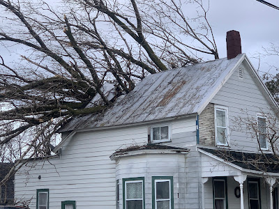
High winds on January 10 toppled a large tree, which
crashed through this St. Albans, Vermont home. 
It will be among the warmest years on record again, much like several previous recent years.  More on that in a post coming along right around New Year's Day.  

The weather extremes of 2024 were all over the place, from wind to floods to drought to heat to cold. Though not that much cold.  The weather often turned destructive, sometimes tragic. 

Weather in Vermont has never been boring. But nowadays, probably because we're in the age of climate change, things are getting even further out of whack. 

Lots of extremes happened in 2024, so let's get into it:  

TWIN WINDS, JANUARY 10 AND 13

Two intense wind storms swept the Northeast including Vermont in mid-January. 

The first of the two hit on January 10. 

Winds gusted to 69 mph at the National Weather Service office in South Burlington, their fourth highest wind gust on record.  Power was cut to 29,000 homes and businesses.

St. Albans was particularly hard hit, with at least three home virtually destroyed by falling trees, with several other houses suffering some damage. 

Along the New Hampshire and Maine coasts, the storm and wind generated a huge and in some case record storm surges which caused massive damage. A new storm a couple day later made everything there even worse 

That second storm hit on January 13, especially along the western slopes of the Green Mountains, where winds topped 80 mph in some spots. The wind blew the roof off a house in Richmond, and fallen trees again blocked numerous roads. Power outages in Vermont again reached a peak of about 29,000 customers. 

FEBRUARY

Another warm winter month. Record warmth on February 9-10  and 27-28 contributed to an average February temperature of 30.2, the third warmest on record. The high temperature of 65 degrees on February 28 would have been the hottest on record in Burlington if not for recent, even bigger February hot spells in 2017 and 2018.

BIG APRIL 3-5 SNOWSTORM
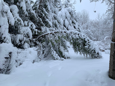
Damaged trees after 16 inches of wet, heavy snow
fell on St. Albans, Vermont in early April. 
One of the biggest April snowstorms on record blanketed the entire state. Biggest snow totals included 24 inches in Moretown in Killington, 21 inches in Underhill and Eden, and 20 inches at Brookfield and Stowe.

Burlington had 10 inches of snow on April 4, its third snowiest April day on record.

The snow was wet and heavy, causing widespread tree damage and power outages. 

VERMONT ECLIPSE GOOD  LUCK

Northern Vermont was in the direct path of the Big Solar Eclipse Of 2024.  It was widely expected that few of  us would see it, as on average we'd have an 80 percent of overcast skies that time of year. 

Instead, the Green Mountain State was blessed with fair skies. There was a broken layer of very thin, high clouds, but that augmented the experience by adding some odd sunset style colors to the sky during the big event. 

We had a second episode of celestial good luck when one of the biggest, brightest most extensive northern lights display graced much of the northern hemisphere as far south as Cuba on the night of May 10.

Though skies had been forecast to be mostly cloudy, most of the night ended up mostly clear in Vermont, allowing for great viewing of the rare event. 

JUNE 18-20 HEAT, STORMS

 Brief but intense heat wave, accompanied by severe thunderstorms in some areas. North Springfield had daily highs during the period of 98, 99 and 101. Union Village Dam in southeastern Vermont had 100 degree highs on two consecutive days. 

Flash flooding in South Burlington, Vermont following
intense storms on June 23. Some of the storms 
prompted tornado warnings, but none were known
to have touched down in Vermont. 

Burlington reached 96 degrees on June 19.  The low temperature that day in Burlington was 80 degrees, tying the record for the warmest overnight low of any day in more than 120 years of records.  

The heat was accompanied by strong storms in some parts of Vermont. After reaching 93 degrees on June 20, Burlington had about an inch of rain within 15 minutes with a storm wind gust of 48 mph.

 Trees came down in Burlington and Stowe, as a precursor to even bigger storms a few days later.

JUNE 23 TORNADO ALERTS AND FLASH FLOOD

A stalled warm front just to the north and an incoming cold front, combined with very humid air set the stage for a severe weather outbreak on June 23.  Forecasters had called for a risk of tornadoes, and in fact a handful of tornado warnings were issued in Vermont as radar showed notable rotation.

Wall clouds and possible funnels were reported, especially near Monkton, but no tornadoes are known to have touched down. There was some tree and power line damage from winds, but that damage appears to have been caused by straight-line winds. 

However, the supercell thunderstorms contained intense downpours, and the two strongest followed roughly the same path across north-central Vermont. The result was flash flooding, the worst of which hit around Stowe and areas around the Worcester Range. Washington County was subsequent declared a federal disaster area due to the flash flood damage.

This flash flood was just a foretaste of what was to come. 

JULY 10 FLOOD DISASTER

Another stalled warm front, and the remnants of Hurricane Beryl caused a new extreme flash flood disaster on the exact anniversary of a similar calamity that hit exactly a year earlier. 

A tractor fell into the ravine created by this road
washout near Hinesburg,  Vermont on July 10.
Unlike the 2023 flash flood, which hit most of Vermont, the July 10, 2024 was mostly focused on northern and central Vermont.  Rainfall totals were as high as nearly seven inches in Hinesburg.

Two deaths were reported in the storm, one in Lyndonville and the other the Peacham. 

This disaster re-flooded homes and businesses damaged in the flood the previous year. Hundreds of roads and bridges suffered significant damage, and as of the end of this year, not all the repairs had been completed yet.  

Some of the more dramatic incidents during this disaster included an apartment building that was mostly swept away in Plainfield. The building's occupants evacuated shortly before the the structure collapsed. 

To nobody's surprise, large swaths of Vermont were declared disaster areas.

The disaster was preceded and followed by oppressive hot, humid weather, which slowed post-disaster cleanup. Lebanon, New Hampshire had a record 12 consecutive days in the 90s from July 6-7. It was Burlington's third hottest July on record. 

EXTRME NEK FLASH FLOOD JULY 30.

Early morning thunderstorms on July 30 dumped an incredible amount of rain in just a few hours in large parts of the Northeast Kingdom. St. Johnsbury received eight inches of rain in just four hours, which is the amount of rain that normally falls there in the summer over the course of two months. 

The resulting flash flood washed away houses in Lyndonville and other towns, but miraculously no deaths were reported. 

But there were close misses. One woman was rescued by neighbors after her house fell into a raging river with her inside it. Two elderly women, one age 98, and their dog, were pulled through their bedroom window by neighbors after their home floated onto a road and thankfully got stuck there instead of washing away and completely disintegrating. 

The storm was highly localized. The eastern end of the town of Danville had 7.4 inches of rain. Another location in the western part of the same town just six miles away received just under an inch of rain. 

A weak upper level low pressure system drifted northwestward into New England and stalled for a time over the Northeast Kingdom, causing the extreme downpours. 

DEBBY REMNANTS CAUSE WIND DAMAGE 
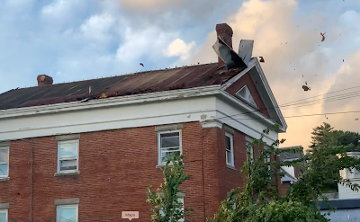
High winds associated with former Hurricane Debby blew
the roof off this building in St. Albans Bay, Vermont. 
The remnants of Hurricane Debby swept over Vermont on August 9, causing a surprisingly strong wind storm that evening. Burlington gusted to 62 mph.  

In Alburgh, a large falling tree crushed a house, trapping a resident inside who was later rescued. The roof blew off a house in St. Albans Bay. 

Numerous roads across Vermont, especially the Champlain Valley, were blocked by fallen trees and power lines. At one point, 49,000 Vermont homes and businesses were without power. 

LATE OCTOBER/EARLY NOVEMBER HEAT

Summer seemingly did not want to quit in the last ten days of October and the opening week of November..

Burlington tied or broke four record highs from October 21 to 31, including a reading of 77 degrees on Halloween. That was the warmest for so late in the season.  Plattsburgh soared to an unbelievable 83 degrees on October 31. Woodstock reached 80 degrees.

The late autumn heat had a final resurgence on November 6 as temperatures climbed to 75 at Union Village Dam, Woodstock and Bennington

FLASH AUTUMN DROUGHT, FIRES

On October 8, no areas of Vermont were in drought. Just eight weeks later, 70 percent of the Green Mountain State was deemed to be enduring drought conditions. 

The drought created a slew of unusual autumn forest and brush fires across the Northeast, including here in Vermont. The Green Mountain State had its worst fire year since at least 2016, thanks to autumn brush fires. One of the fires burned through 70 acres near Barnard. 

HOT YEAR ENDS ON HOT NOTE 

2024 will be the world's hottest year, and the hottest year on record here in Vermont. The year came to a fitting end with a record heat wave on December 29-30.  The temperature reached 61 in Burlington on December 29 and 60 on December 30, both record highs for the date. 

 

Wednesday, May 1, 2024

April Vermont Summary: Another Warm Month; Precipitation Pretty Average

Though April was a rather warm month, a big snowstorm
on April 4-5 didn't inspire much hope for spring. 
 The figures are in for April and, despite a big snowstorm toward the beginning on the month, we had another warm one.   

The Warmth

Most weather stations in Vermont averaged around a degree warmer than normal, give or take. But this is a "new" climate change normal, which takes into account the mean of the past 30 years.  Those years are warmer than what was typical of the 20th century, so the figures are a big skewed.

Let's take Burlington for example. The average temperature for April, 2024 was 46.9 degrees, or 1.3 degrees warmer than this "new" normal. But of the past 133 Aprils in Burlington, I could only find 17 Aprils that were as warm or warmer than this one.

Five of the Aprils that were warmer than 2024's version have happened since 2008.  

Also note that under this "new" normal, only one of the past eight months has been cooler than average. El Nino, which tends to warm us up, no doubt contributed to the warmth over the past year. Still, this isn't your grandfather's climate here in Vermont. 

Precipitation

Rainfall in Vermont was a little below average in the east of the Green Mountains and perhaps in some sections of central Vermont. Much of western Vermont was a little one the wet side, but not by much. 

For instance, Burlington clocked in with 3.21 inches of rain, which is just 0.14 inches above normal. There's been a mini-trend toward wet Aprils in recent years. Six of the past eight of them in Burlington were on the wet side. 

But spring did arrive amid consistently mild 
temperatures most of the month. A hard freeze on
April 25-26 didn't cause much damage. 

It seems like it's been a wet year so far, and it has. However, it's not that wet. Precipitation in Burlington through April 30 is 10.92 inches, or 1.71 inches above normal for this spot on the calendar. 

The only extreme weather in Vermont during April, 2024 was the big snowstorm on April 4-5.  Burlington collected 10 inches of snow in that episode, which means the month tied for the tenth snowiest April on record. 

Most of central and northern Vermont had at least a foot of snow in that storm, with several spots closing in on two feet. That's very impressive for an April snowstorm. The storm left 33,000 Vermont homes and businesses without power.

Almost equally as impressive is how fast the snow melted away. Snow depth at my house in St. Albans, Vermont went from 14 inches on the morning of April 5 to pretty much nothing by the time the total eclipse of the sun arrived on the afternoon of April 8.

A little more snow announced the start of a spell of hard freezes o April 24, but pretty much nobody saw any accumulations. Most gardens managed to survive the subsequent two nights with temperatures well down into the 20s and even upper teens.

The Big Event

Ah yes, the eclipse.  Certainly the big event of April, 2024 and a huge event in our lifetimes.

Climatologically, we had an 80 percent chance of overcast skies at the time of the eclipse. Literally for years before the eclipse I was pessimistic about how cloudy the skies would be. 

During the total eclipse of the sun on April 8, shown here
in St. Albans, high thin clouds added some color to
the skies near the horizon, as if it were a sunset. 

 In the months leading up to the eclipse, I kept saying the weather on eclipse day would feature dense fog with freezing drizzle.

The forecast on the morning of April 8 was a nail biter, as clouds began to encroach in the hours before the big event. 

In turned out the clouds only enhanced the experience. The clouds didn't cover the whole sky, and they were quite thin and wispy.  They formed a neat halo around the sun as the moon's shadow began to take bites out of the sun's disc.

When the total eclipse hit, the high clouds added some beautiful colors to the horizon as northern Vermont plunged into darkness. You could still clearly see the edges of the sun peeking from behind the moon during that incredible afternoon. We got totally lucky, pardon the pun, with the weather on the afternoon of April 8. 

Looking Ahead

As I say every month, it's hard to tease out what the upcoming months weather will be like. Long range forecasts through most of the first half of May suggest temperatures and rainfall might be close to normal. But as always, there will be some surprises in that department. 

Usually, May brings us our first taste of true summer weather. You know, 80s with noticeable humidity. 

That kind of weather knocked on our doorstep early this week, but got cut off at the pass so that most of New England stayed cool. 

I don't see any signs of such summer weather in any of the forecasts for the foreseeable future. Enjoy the temperate weather while it lasts. Long range forecasts from the National Weather Service suggest we'll have a hot summer.

We shall see! 

Monday, April 15, 2024

Bonkers Eclipse/Climate Change Claim Has Eyes Rolling And Fuels False Climate Skepticism

 Everybody, including me, was all gaga on April 8 for the "Great American Eclipse."

No, my dear Sunny Hostin of "The View," the April 8
eclipse had nothing to do with climate change. 
The event dominated the news, hell the entire media. It was a spectacle, so no harm in enjoying the fun and making it a media event. Those cable networks have got to pay the bills somehow, right?  

Until things go off the rails. So it was on "The View" during the midst or eclipse day. 

Co-host Sunny Hostin at first seemed sane, joking about the wacko conspiracy theorists who told us the eclipse would bring on the Rapture. Spoiler: It didn't. Apparently, it's been postponed until April 23, so stay tuned. Of course, it was originally supposed to arrive on April 23, 2018.  

I guess God has had a lot of scheduling conflicts.

Anyway, back to "The View"

Hostin noted the earthquake that hit New Jersey the Friday before, and said she just learned cicadas about to emerge, which apparently freaks her out a little bit. (Cicadas on 17 and 13-year cycles are scheduled to appear this year, scientists have known this since, like, forever). 

The Hostin dropped this gem: "Let's say, all those things coming together maybe lead one to believe that either climate change exists, or something is really going on."

Ooookay!

For the record, the eclipse, the earthquake and the cicadas have absolutely nothing to do with climate change. But you knew that already, if you have half a brain.  

Sad that another co-host, Joy Behar had to remind Hostin that earthquakes happen underground so climate change doesn't influence them. And eclipses are celestial events, in no way influenced by Earth's climate. 

Of course, our friend Sunny set off a lot of commentary, mostly about the sad state of political and social discourse in our fine nation. Since I'm a cranky old man, I'll pile on. 

Everything is about frightening people or mocking them. 

"Politics unfortunately is a lot about fear," said Cenk Uygur on his "Young Turks" show after he and co-host Ana Kasparian cringed at Hostin's remarks. People will use anything to gin up fear, from migrants to drag queens reading books to children. 

I don't know what Hostin's motivation was but geez.

You see that fear mongering all the time, and it gets taken to ridiculous levels by all sorts of people. It's why the likes of Marjorie Taylor Greene was telling us to repent because the earthquake and eclipse were signs from God.  I doubt she believes that crap, but she's hoping the people who she surely considers "the rubes" will fall for it and fearfully gravitate toward Donald Trump. Or something. 

I also think Greene might be smarter in some ways than we think.  Some of the stupid things she says are probably attempts to connect with those "rubes"she likely  has contempt for.

Plus, Greene might have know in advance she'd get mocked for that stupid social media post about eclipses and repenting.  She had to know that would keep her in the news - she's an attention whore after all - and she had to know the mocking she'd receive would help unify people of a certain ilk behind her. 

Politics is also all about mocking. Dumb statements like Hostin's are fodder for the types that try to deny something much bigger. Greene is only too eager to help with her silliness.

It's all about pecking at the credibility of people who actually know a thing or two about climate change.  The talking points among the right wing are that Hostin said a dumb thing about climate change, so anybody who says anything about the dangers of climate change is also dumb.  

It's a way to get people to stop trusting people like mentally balanced scientists and instead embracing demagogues. 

This method probably works better than you'd think.   Which is why authoritarianism is on the march around the world, including here in the United States. Find enough ways to make people fearful, and that's what you get 

This is Authoritarianism 101, and you'd better pay attention. Before people like Hostin and Greene end up in charge of us all.  

Tuesday, April 9, 2024

Eclipse Over, And Now Spring Sneaks In, And Another Big Storm Looms

 Phew, what a day Monday,  huh?

Spring is back and so are the gardens. The snow from 
last week has melted (you can still see a small
pile of snow to the right where it slid off the roof)
Warm weather and rain will make spring
advance further, but end of week flood risk?
The traffic jams from people departing Vermont after the eclipse have cleared up and we can catch our breath.  

While doing that, we realize spring has really snuck while we were distracted by the spectacle. Plus, another pretty big storm is on the way. Spoiler: This next system definitely won't be a snowstorm. 

For most of us now in the valleys, that big snow from last Thursday is almost just a memory. Here at my house in St. Albans, Vermont the 14 inches of snow that was on the ground last Friday morning is as of this morning reduced to just some patches that will disappear today. 

Suddenly, looking around the yard, there's crocuses blooming everywhere and many clumps of daffodils have flower buds. I think I'll have blooms within days. 

WARM, WET WEEK

The weather this week will encourage those flowers and green grass.

Before the eclipse chilled us down briefly Monday afternoon, we ended up having the warmest day so far this spring after all. Burlington reached 65 degrees, about eight degrees warmer than forecast. 

Today is going to be another warm one, but will also be the last dry day of the week.  We should see quite a bit of sun, with temperatures in most valleys reaching the low 60s again.  A very nice day. 

Clouds come in tonight as the first of two storm systems begin to affect us. The first one is not very big. It's the remnants of that powerful storm that caused those wicked, damaging winds in Colorado last weekend. 

The storm is now a shadow of its former self, having limped across the Minnesota border into Ontario, Canada. It will swing its dying cold front our way late tonight and tomorrow.

The results will be a showery day.  Hey, April flowers bring those May flowers, right?. Or mid to late April flowers, whatever.  Despite the recent snows, it's still a decidedly earlier than normal spring in Vermont, and this week is keeping up the seasons's fast pace. It'll still be fairly mild tomorrow despite the clouds, reaching the 50s.

The warmth today and the light rain tomorrow will keep the snow in the higher elevations melting, so rivers will stay swift and high through today through the rest of the week. We won't have to deal with any flooding through Thursday morning. And then.....

STRONG STORM

The tail end of that dying cold front coming into Vermont tomorrow is way, way down in Texas. That's why it was cloudy in much of the Lone Star State for their eclipse experience. 

What will turn out to be a big storm is forming at that tail end in Texas. It's already caused some severe weather in Texas Monday evening. This developing storm also looks like it will cause a pretty nasty severe weather, tornado and flood outbreak in the South over the the next couple of days.  

A strong storm system is forecast to be affecting
us in Vermont for the second Thursday/Friday in
a row. This next one will be rain, not snow.

Tornadoes, some strong and gorilla hail are in the forecast today for eastern Texas and Louisiana. An even more serious tornado and flood threat seems possible tomorrow in the Gulf Coast states as the storm matures.

As you can tell already, this storm will have lots of moisture and energy to work with. It's forecast to strengthen even further as it plows northward to the eastern Great Lakes Thursday night or very early Friday.

We'll be on the warm side of this storm. You'll notice it turning rather humid for the season here in Vermont Thursday and Thursday night. 

The storm's surge of moisture will keep the rain going for most of the day and night, with only brief breaks. Lows Thursday night could stay up in the 50s, which is quite mild for this time of year. 

If the forecast holds, you'll wake up to a rather strangely warm and humid Friday morning. Depending on the timing of the storm's cold front, we could even end up with some thunderstorms Friday. 

In any event, this storm will produce a fair amount of rain, possibly one or two inches. Locally more if there's thunderstorms. The ground is quite wet from all that snow that just melted, and there's more snow in the mountains to go.

The result is a Vermont flood risk by Thursday night and Friday. 

At this point it certainly doesn't look like it'll be anything catastrophic. We don't need that! But minor flooding is possible. We'll have details as we get closer to the event. 

It looks like this storm will carry quite a bit of wind, too. I doubt it will be nearly as bad as the damaging gusts during the early stages of last week's winter storm. But there still could be a few power outages.

Finer details to come as the storm gets closer later in the week.

The warmth and humidity will also push spring's progress along even faster. 

It also looks like we'll have a brief spell of raw, chilly, showery weather next Saturday and possibly Sunday.  

Monday, April 8, 2024

Eclipse Thrills Vermonters As Skies Cooperate For The Spectacle

 That. Was. Awesome.   

The view from my St. Albans, Vermont house during today's
total eclipse of the sum. The light in the distance is far
to our northwest, just outside the path of totality. 

Throngs of people watched gobsmacked as the total eclipse of the sun passed over northern Vermont. My husband and I were two of those gobsmacked people. 

Video of the experience is at the bottom of this post.   

Judging from news reports, large parts of the eclipse path had fewer clouds than many expected, which is definitely nice. The more people who could participate the better, as far as I'm concerned. 

As my husband and I settled into our  chairs on the back deck, our silly looking eclipse glasses on, we quickly discovered -  much to our delight - that the high clouds that had moved in did not mess with the spectacle at all. 

 Through the eclipse glasses, one could clearly see the moon eating up the sun. At totality, the edges of the sun could clearly be seen the darkness peeking out through the edges of the moon's shadow. 

The broken wisps of thin clouds actually seemed to enhance the show.  Before and during most of the time the sun slowly disappeared, the high clouds created a ring around the sun. That's typical when there's a veil of cirrus overhead. . As the sun slowly slipped behind the moon, the ring seemed to expand, and the orange color in the ring became dominant.

The sunlight slowly faded into a sort of sick orange yellow. Daffodil plants poking out of the ground turned a strange sort of unnatural dark green.   The blue sky to the northeast was a deeper, darker blue than I've ever seen in the sky. 

As the light dimmed here in St. Albans, Vermont, birds made their evening calls. Two hawks circled overhead for some reason. A few crows, part of a large murder of them that roost nightly up on the hill behind our house, seemed confused and flew low and slowly and cautiously just above the shed. 

Mosquitoes also came out. 

We live on a southwest facing hill in St. Albans, Vermont, so the view was perfect. Just before totality, a band of blue skies to the southwest suddenly turned black, making it look as if a storm was approaching. 

At the moment we plunged into darkness we could hear a cheer go up in Taylor Park, a little over a mile away, from the throng that had gathered there. Streetlights blinked on.  I could see somebody's flashlight  at a neighbor's house. 

During totality we could see the zone outside the total eclipse far to the west. The high clouds there took on sunset colors. 

Four minutes before totality in St. Albans, Vermont,
the ring around the sun created by the high clouds
became more noticeable, and seemed to expand. 

It seemed like a frozen moment during totality. Everything grew quiet after that initial cheer from the park. There were no cars on the road. 

 The woods, the yard everything was silent. Even Jackson the Weather Dog, who was constantly seeking our attention as the light faded, grew quiet and lay down quietly by our feet in the sudden darkness.  

Just before totality ended, the sky that had turned black to the southwest turned blue again, and that blue sky, flecked with those high clouds, raced northeastward toward us. 

In the moment the sun emerged, there was just a tiny, but brilliant bright spot - the famous diamond ring effect.  (I think a cloud partly obscured that feature as we went into totality. 

As the light returned, I heard a couple robins make that happy chirp they usually make at dawn. The slight breeze that went calm during the eclipse returned. 

The temperature outside the house dropped from 59 degrees a few minutes before the moon's shadow started to cross the sun at around 2:15 to 47 degrees just after the sun re-emerged. That's a 12 degree drop. I think I was right. The humidity today was very low, and that allowed the temperature to fluctuate a lotl

By 5:15 p.m. the temperature was back up to 58 degrees. 

I so hope everyone in the path of the eclipse had as wonderful an experience as my husband and I did.  It was a once and a life time experience, and I'm so lucky I spent it alone with the person I love the most 

And of course our unimpressed Jackson the Weather Dog. 

Video:  What it looked like from my house in St. Albans, Vermont. Click on this link to view, or if you see the image below, click on that. 


Typical Vermont: The Clouds Roll In Just In Time For Today's Eclipse Moment, But Still A Spectacle.

 Welcome to eclipse day in Vermont! 

This is a cloud forecast map for eclipse time
this afternoon from NOAA's Storm Prediction Center.
Red areas are where forecasters expect high, thin
clouds, with potential to still have a decent
view of the eclipse. Green is mid-level clouds
which wouldn't be great. Blue is low clouds
which is a worst case scenario for eclipse watching. 
And along the rest of the path from Mexico, and from Texas to Maine and on into southeastern Canada. 

Here in Vermont, if only we could hold on to the skies that greeted us at dawn. There wasn't a single cloud out there. As the sun rose, the sky was as blue as possible. 

ECLIPSE CLOUDS

No good weather goes unpunished in Vermont, as you know, so the clouds will roll in today right before the eclipse starts. 

I'm still not saying the clouds will completely ruin the spectacle.  Not even close. It will still be so, so worth stepping outside to check it out. 

It could have been many, many times worse.  Could you imagine what a cold, wet mess and disappointment this whole eclipse thing in Vermont would have been had it hit during our huge spring snowstorm last Thursday?

But if only the clouds would come in like three hours later than currently scheduled. Alas, that is not to be. Except maybe in the Northeast Kingdom, which might hold on to the clear skies. In general, the view will get worse the farther west you go.  

Western Vermont should be at least be so-so.  The Adirondacks and the rest of northern New York will probably have the worst viewing in the region. Northern New Hampshire and Maine look to be spectacularly clear. 

Thank goodness they will be higher, somewhat thinner clouds.  A lower overcast would be much worse.  Places like Texas, Arkansas, Pennsylvania and western New York along the path of totality will struggle with those lower, thicker clouds during the event. 

It is fun to watch the sun slowly get eaten up by the moon getting in the way. That part of your eclipse task today might be problematic, but not impossible, as you'll sort of see the sun through the high clouds.  In the Northeast Kingdom, you could be in fine shape, as the clouds might not make it there until the sun is in the process of re-emerging from behind the moon. 

As far as the spectacle of it going dark, with odd light and shadows in the sky and landscape, we're still golden here in Vermont.  I'm still expecting quite a show. 

The forecast for this hasn't changed much since last evening. It's still looking like low clouds, which would really mess things up, will stay to our west, in western  New York. We'll have high clouds, so most of the time during the eclipse hour, the sun should at least weakly shine through. That is until the moon gets in the way, of course. 

GREAT VISIBILITY 

Here in Vermont, we will have absolutely no low clouds, fog, precipitation, haze or wildfire smoke to obscure the landscape. The humidity in the air will be quite low today, so that helps put everything in sharp relief.  

This is the view from where I will take in the eclipse
today. Skies were brilliant blue when I took this
photo at 7:15 a.m. today.  High clouds will
interfere with the eclipse view at least somewhat
by the time it rolls around this afternoon. 

The view of the mountains, lake, clouds, forest, fields, town or city wherever you are in the path of totality today will be as good as it possibly can get. 

I'd suggest parking yourself in a spot that has wide ranging views, where you can see mountains and hills and fields for a large distance. If you're on shore of Lake Champlain, or on a hill, that will probably be your best ticket.

Just remember to set up shop in a public place that's off the road and easy to access.  Don't go onto private property unless you have explicit permission from the landowner. 

And please, please, stay on the paved roads. The dirt roads are a mess from all the snow that melted yesterday. On paved roads, I'd be super careful if you're tempted to pull over onto the shoulder. It's a safety thing as you'd partially block traffic. And the sides of the roads are soft and muddy, too, so that can get you stuck.

Many places still have snow on the ground, and that snow will be rapidly melting and creating lots more mud today. 

TEMPERATURES

For outdoor comfort, you really can't get better than this for early April in Vermont. It was chilly and frosty this morning, but the sun will really warm up the air. 

Remember earlier how I said the humidity is really low today?  Dry air really reacts to the sun. The temperature can change much more rapidly than if it were damp or humid out there. Which means the   eclipse weather looks like it will be really interesting. 

In the valleys, the temperature this morning will rocket upwards through the 30s, 40s and 50s, maybe touching 60 degrees by 2 p.m.

The eclipse will hit right when we normally have peak heating for the day.  The eclipse will begin at around 2:15 and the amount of sunshine coming in will decrease.  With totality, it will get colder.  The rule of thumb is the temperature usually goes down by about five degrees during an eclipse.

I wonder -  since the air is so dry - whether the temperature will drop more than that five degrees. And I wonder how much the temperature will recover once the eclipse is over, since it will be late afternoon by then. 

In any event, bring a jacket, even if the sunshine feels really warm in the early afternoon. 

GOING HOME

For those heading home to wherever they came from after the eclipse, there should be no travel trouble, other than thick traffic. No rain, snow, sleet or fog anywhere near us. 

A good suggestion is to wait until tomorrow to leave Vermont so you don't have to deal with so much traffic this evening. That's a great plan in terms of weather. No inclement weather is in the cards for the region until Wednesday, when some rain showers will creep in. 


Sunday, April 7, 2024

Sunday Evening Vermont Eclipse Forecast: Trending Cloudier

St. Albans Bay. Vermont, around 3:30 pm. today, just 24 hours
before the eclipse. Would have been nice if it happened
today instead of tomorrow, when high clouds will
very likely make the view of the event somewhat fuzzy.
 Today would have been a great day for an eclipse, huh? 

Morning clouds quickly scoured out to reveal a blue bird day. It was a fine spring day close to Lake Champlain, where the snow had disappeared, and a gorgeous late winter day where the snow remained. 

Of course, this being Vermont, you can never have the weather you want, when you want. 

Forecasts keep trending cloudier for the hours around the eclipse on Monday.  By cloudier, I definitely don't mean to say the eclipse will be a no-show.

You will still see a spectacle, but it won't be a crystal clear view like you would have gotten today. Monday will start off cloud-free, but you'll see more and more of those high clouds as the late morning and afternoon progress. 

The clouds Monday afternoon still look to be high and thin, so most of us in Vermont should still sort of see the sun disappear behind the moon. The darkness that takes over will still be really cool. Those high clouds will also probably make some interesting colors and features in the sky.  

It's VERY important to note the thin clouds will not protect your eyes at all. You MUST wear those special eclipse glasses if you're looking up at the sun and following the progress of the eclipse. You can take the glasses off only during the total eclipse, when the sun is completely hidden. 

Horizontal visibility will remain excellent at eclipse time.   No fog, no haze, no wildfire smoke. So you'll see how the eclipse affects distant mountains, lakes and clouds as it progresses. During the total eclipse, you'll see a little light in the distance, in places where the eclipse already passed, or is yet to hit.  

Bottom line: The increasingly cloudy forecast is by no means a complete disappointment. Not even close. 

A low overcast with fog would have been exponentially worse than the expected conditions Monday afternoon. Had we gotten that low overcast and mist,  a dark dreary day would have just gotten much darker for a little while. Yawn. 

So we're still doing well.

The National Weather Service in South Burlington noted that they had to adjust forecast high temperatures downward under and near the path of the eclipse.   Highs in the valleys without the eclipse tomorrow would probably have been in the 60 to 65 degree range.

But the timing of the eclipse - more or less around the time of peak heating - means meteorologists had to trim back expected highs to between 55 and 60.  Tomorrow will probably not be the warmest day so far this spring because of the eclipse.   

I'm sure we'll get over that "disappointment." Temperatures will also probably fall by at least five or six degrees during the eclipse, then partially recover afterwards. 

Hopefully the cloud forecast won't get much worse. I don't think it will. The high clouds will be caused by a dying warm front approaching from the southwest. An active or sharpening warm front would have thrown even more clouds our way. 

So all in all, we're still doing pretty well with this thing in Vermont. 


Vermont Eclipse Forecast: High Clouds, But Still A Great Show

High, thin clouds are expected to appear in the skies over
much of Vermont by the time the eclipse arrives Monday,
but the clouds will be thin enough so that we
should still enjoy a great show. 
 We have another instance coming up in which Vermont is wonderful, but not perfect.

That would be the eclipse.   

Tomorrow is the big day, so the forecasts are almost locked in. There could still be some changes, but meteorologists seem fairly confident about what's going to happen Monday 

HIGH CLOUDS 

The way the forecast for Monday looks now, a bluebird clear blue morning will be invaded by high, thin clouds by the time the eclipse rolls around in the afternoon. 

The great news is this will be no means be a thick overcast.  To an extent, you'll be able to see through the clouds and take in a lot of what's going on.  We're still in for a great show. 

You'll most likely still see the moon takes bites out of the sun as if it's eating a vanilla wafer, then cover the sun entirely. (You will be watching all this with your special eclipse glasses on, of course). The changing, fading light as the eclipse draws close will still be stunning. 

Maybe the clouds will enhance the experience. It will be interesting to see how the thin clouds look during the eclipse and the moment just before and after. There might be some interesting colors or shadows or effects because of those clouds. 

The high clouds, of course are making things not perfect. Especially for photographers and people who want an unobstructed view of it all. The eclipse will result in fantastic photographs, of course. But a crystal clear sight is probably not in the cards, for those who wanted pristine shots of the edges of the sun peeking from behind the moon. 

The thinnest, most scattered clouds along the eclipse route in Vermont will be in the Northeast Kingdom. 

Two or three days ago, the high clouds were initially forecast to only make it as far east as around Buffalo, New York. But each computer model run had the band of high clouds moving faster. So now, unless the computer models reverse themselves, we'll see the cirrus clouds overhead in the Green Mountain State. 

This is so much better than climatology would have it, though. This is a terribly cloudy time of year in Vermont. It's usually stormy You might remember the news stories a few weeks ago saying we had an 80 percent chance of overcast during the eclipse. 

Notice how most of us didn't see the sun this past Wednesday through Saturday. This coming week, Wednesday through at least Saturday, also looks like it will be overcast and dismal. 

The clouds this time of year are often thick and low. Can you imagine how disappointing the eclipse would have been had it hit during the big snowstorm Thursday, or amid the damp overcast of Friday?

Fingers crossed that the high clouds won't thicken up, but it appears we might be beating the odds. Despite the thin clouds, Vermont is catching a big break, timed well for the eclipse.

Temperatures will be comfortable for viewers, too.  We'll get well into the 50s just prior to the eclipse, though temperatures of course will drop noticeably during the event as the sun disappears.

NO HIKING!

Although we'll have pretty good viewing weather for the eclipse, there are certain things that are a really, really bad idea during the eclipse.  

For instance, if you know anybody who thinks it would be fun to hike to a mountain summit to view the eclipse, strongly tell them to think again. You're not supposed to use hiking trails this time of year anyway because it's mud season and you'll damage the trails. 

Even though the weather forecast looks good, we'll also have the worst possible weather Monday to hit the hiking trails. We just had a lot of snow and it will be melting rapidly Monday. The cold, running water and deep mud on the trails will be awful. There will still be a ton of snow in the highest elevations. (There's still six or seven feet of it atop Mount Mansfield). 

There's tons of ice to slip and fall on, too.

If you get stuck in the mountains, cell service will be spotty at best if you need to call for help. Cell service will be especially strained due to the heavy use expected.

Rescue crews will be stretched thin, too. If you get into trouble up in the mountains, you might not get help until well into the night. By then, temperatures will be in the 20s up there.

BOATING A BAD IDEA

Although winds will be light and waves pretty minimal, it's still a bad idea to take a boat or kayak or anything like that out onto Lake Champlain or other bodies of water for the eclipse. Water temperatures are still in the 30s in most areas. If you fall in, you won't last long. 

If you want a lake in your eclipse view, pick a spot on the shore with a nice west and south facing view.  Burlington's Waterfront and St. Albans Bay Town Park are great spots for eclipse lake views, but expect crowds and traffic. Note there will be some street closures in Burlington and other communities. 

STICK TO THE PAVEMENT

With all the melting snow and thawing frost and heavy precipitation we had all winter, back roads and dirt roads will be an absolute mess. I know some of you might want a spectacular, rural view of the eclipse. Most dirt roads will be mud bogs, though. It'll be really easy to get stuck. And really hard to obtain help getting pulled out. Definitely best to stay on the paved roads. 

Don't believe the GPS in your car. It often lies and can send you to a remote dirt road, often not maintained well.  Thursday's snow has long since been removed from paved roads and they will all be in great shape Monday, aside from the occasional pot hole and frost heave.

PICK YOUR SPOT

You'll want to plan ahead for this one. 

Today might be a good day to scout out a place where you'd like to view the eclipse.  Maybe go out between 2 and 4 p.m. this afternoon to judge spots where the eclipse will look good to you.  Unobstructed west and south views are best. 

Remember, traffic will be thick Monday, so allow plenty of time to get to your viewing spot. It'll be a bummer to be stuck on the roads when the eclipse hits, so be where you want to be ahead of time. Make sure you have a tank full of gas. And snacks and beverages. You might be stuck in traffic after it all ends. 

DON'T SWEAT IT

This is a once in a lifetime opportunity, so stay positive. Don't road rage in the traffic. Don't elbow people away to get a view. Don't tromp across private property. There's plenty of public areas to watch the spectacle. Don't be a Karen. There will be no eclipse manager to entertain your bullcrap.

Just enjoy the experience and live in the moment during the eclipse. 

It will be quite a moment. 

Saturday, April 6, 2024

The Eclipse Will Make Its Own Weather In Vermont And Elsewhere

 They tell me it's sensory overload when a total eclipse of the sun arrives, like it will on Monday.

Monday's eclipse path through Vermont. Expect big
changes in the weather and nature during the 
event, no matter what sky conditions are like at the start.
It's looking like Vermont will have a partly obscured view of the eclipse. High thin clouds will be increasing at the time of the event. We'll still be able to see it. The spectacle will just be filtered by the high clouds somewhat. 

It's a better scenario than the low, thick clouds we had with the storm Thursday and Friday. 

With at least some sunshine still in the forecast, you'll also notice how the eclipse will make its own weather. 

Temperatures

Forecast highs Monday afternoon are in the low to mid 50s.  I'm not sure whether meteorologists have factored the eclipse into that prediction. But I strongly suspect afternoon highs Monday will be a little cooler than they would have been without the eclipse.

The eclipse hits Vermont right around 3:30 in the afternoon.  Usually at that hour, we're approaching the high temperature for the day. But with dimming, then disappearing sunlight, the journey to a high temperatures will be interrupted. 

The chill during the eclipse will be noticeable for sure. As the Washington Post explains, a dry environment will get about 8 to 14 degrees cooler during the eclipse while readings will only drop by 5 to 10 degrees.

The air is forecast to be quite dry over Vermont during the eclipse, so there could be quite a cool down.  A wild card is for places that might still have a snow cover.  Light winds are are also in the forecast for Vermont eclipse time. 

 I wonder if places that still have a snow cover might see the bottom drop out of the temperature. It could be akin to those clear, cold winter evenings when the temperature crashes big time when the sun sets.  It'll be a fun experiment to see.

For fun you ought to bring a thermometer out. Leave it in the shade, as that will measure the ambient air. Note the temperature as the eclipse starts, and see how it changes as things gradually go dark, then light again. 

The temperature might actually reach its minimum a short time after the eclipse is over.  It takes time for the sun to start heating the atmosphere again. 

Wind

Like I mentioned earlier, we're not expecting much in the way of breezes on eclipse day. But this time of year, updrafts created by the sun mix the air, which does create some wind even if there's no storm nearby to generate anything strong. 

You'll probably notice some light breezes before the eclipse starts. Chances are, they'll diminish during the eclipse. That's because the sun won't be there at the peak to generate those updrafts.

Wind direction might change, too.  I'm curious to see what happens at my house in St. Albans. During the day, winds more often than not come out the west. Often at night, the breezes shift to more easterly as cool air drains off the Green Mountains into the Champlain Valley. 

Will this wind shift happen during Monday's eclipse?  Inquiring minds like mine want to find out. 

Showers and Clouds

Eclipses can help squelch showers and thunderstorms, too. That won't be a factor in Vermont, as instability showers are not in the forecast for Monday. 

It might be fascinating to watch Texas. Severe thunderstorms are in the forecast Monday for part of the eclipse path down there. Severe storms usually on the sun heating the lower atmosphere. That encourages the updrafts that help towering thunderstorm clouds grow.

That's why, in the summer, thunderstorms usually hit in the late afternoon and evening. That's when the clouds have taken the most advantage of the sun's heat. Those thunderstorms usually diminish after sunset. 

As the sun disappears in the eclipse, will wannabe thunderstorm clouds shrivel like they do during a typical sunset? And will they re-form after the eclipse is over? Chances are they will, as other factors in the atmosphere will encourage the Texas storms. 

Nature And Pets

Animals will surely be confused by this event. 

This time of year, robins around my house seem to break into happy song as dawn breaks and issue alarm calls when the sun is setting. 

Will I hear those alarm calls when the eclipse starts? Will the happy songs start once it's over?  Pay attention if you can to what happens with nature and animals around you during this event. 

As people get louder, nature gets quieter during an eclipse. 

Also, it might be interesting to see how your pets and other domesticated animals behave.  Will they act like they do at sunset? Or get confused and agitated?

Your dog will be fine, by the way.  Unless you take them into a crowd where they might get nervous or get themselves into trouble.

I'm lucky enough to live right in the middle of the path of totality. I know my dog will be fine. Jackson will be happy as long as he gets to participate with us. He'll be out on the deck with my husband and me enjoying the spectacle. 

There's no need to put eclipse glasses on your pets. Unlike humans, they're smart enough to never look at the sun, and they won't start doing so during the eclipse. 

People

This isn't weather related, but as you can imagine, total eclipses generate big feelings. Of course, during an eclipse we know what's going on, we know it's not dangerous (unless you're dumb enough to look directly at the sun without special glasses) and with the exception of certain eccentric politicians, an eclipse is not any kind of omen to worry about. 

Still, even the most calm, rational people get overwhelmed by eclipses. Embrace the emotions. Your heart might race, you might be brought to tears, or be lost in the thrill of it, or you might have other strong emotions or none of the above. 

Just be you and embrace the spectacle.  

Sunday, March 31, 2024

Vermont Weather Week Ahead: A Big Winter Storm? In April?

 This should we an interesting weather week for the nation as a whole and here in Vermont. 

This is just one of many depictions of how a huge
storm would affect us in Vermont later this
week. This map shows an enormous
nor'easter centered just off Cape Cod. We
could get a lot of snow and/or rain out of this.
For the U.S., it's another everything but the kitchen sink deal. And maybe the kitchen sink, too.  

The storm has already set off heavy snow in some of the mountains of the West, and even a few severe thunderstorms for parts of California.

The developing storm is threatening to set off more wildfires in New Mexico, western Texas, parts of Colorado and western Oklahoma as the system sends dry, warm winds through the region.

A large severe weather outbreak will start today to an extent in Missouri and Illinois. Then the threat grows larger Monday and Tuesday through a much more expansive area in the Midwest and Southeast.

Flooding is also a threat in parts of the south and east. Some areas will get heavy snow out of this, which is where Vermont and other parts of the Northeast come in. 

VERMONT STORM

The storm in question looks like it will be pretty large, powerful and slow moving, so it'll have a chance to give quite a bit of weather to the Northeast. 

Some areas, especially the higher elevations could get a ton of new snow out of this, but the devil of course is always in the details. 

The easy part will be to go through the calm before the storm, so we'll do that first

Today

Not bad for an early Easter! Clouds from a weak overnight disturbance were clearing out this morning and we should have a largely sunny, seasonable day. Expect highs in the 40s, with a few warmer valleys touching 50 degrees

Monday

An initial disturbance, the opening salvo of this big storm, is the piece producing the potential severe weather in Missouri today. It'll pass by to our south tomorrow, sending some clouds our way. It'll be cloudiest south with even a chance of a light shower. There should be at least some sun north. Another seasonable day with 40s to around 50, warmest north.

Tuesday

Here it comes. Starting here, the forecast is subject to HUGE changes. A storm this big and complex is sure to provide quite a few surprises. 

It does seem as if this storm will be bigger and more powerful than your average early April system. We don't know yet who gets the most rain, the most snow, and precisely how long it will last.

We'll give the broad brush here, and I note future posts in this here blog thingy will highlight changes  to the forecast I lay out there. This initial crack at the forecast is just to give you a general idea of what will happen.  

My perennial gardens in St. Albans, Vermont showing
signs of springtime life this Easter Sunday morning,
but these plants could well be buried in 
snow by midweek. 

In the end, I think virtually everyone in Vermont will see some snow. Some of us will only get a little. Some of us could really get clobbered,

Anyway, clouds thicken and lower Tuesday and rain will break out. The storm will end up somewhere near Lake Erie overnight Tuesday. At that point, the early read on this is valleys in Vermont will be getting rain, while it will already be snowing in the mountains. 

Then it gets even more interesting.....

Wednesday

The main storm center near Lake Erie will begin to fade out as a new storm gets going on the Mid-Atlantic coast and moves northward, becoming a strong nor'easter centered near southeastern New England by Wednesday night. 

This arrangement feeds plenty of moisture inland through New England and also allows temperatures to cool well away from the coast. That's us.

This would allow at least a mix of rain and snow in the valleys and probably all snow up high.  Depending on the path of the storm, I already see a potential for over a foot in some high elevations of Vermont. If that happens, I don't know where yet. It depends on whether the storm is a little inland or a little off the coast. 

Inland would give most of Vermont a lot of snow. Offshore would favor mostly southern parts of the state. 

Thursday

The storm seems like it might want to pretty much stall somewhere near eastern New England or just offshore Thursday. If that happens, the storm for Vermont would turn into one of those wrap-around storms. 

That could bring a lot of snow to the western slopes and summits of the Greens, but not much additional snow to southeastern Vermont. We'll see how it plays out. 

Friday-Weekend

The storm as it stands now would slowly drift eastward and weaken somewhat, so snow and maybe valley rains would slowly diminish. Timing of this is a big question mark. Will the precipitation end fairly quickly, or linger through the weekend?

Eclipse Day Monday

The storm should be out of our hair by then, which is great news. But it's still way too soon if it will actually be clear out so we can actually see this once in a lifetime event. 

Long range forecasts - at least at the ,moment - do not have any large scale storms near Vermont at the time the eclipse rolls around. But it only takes a weak weather disturbance to make our skies overcast. It's way too soon as of this Easter morning to know if anything will cloud our skies on eclipse day. 

Keep praying to the weather gods for a clear April 8! 


Friday, March 29, 2024

A First Heads Up: Some Sort Of Nasty Storm To Affect Vermont, Many Others Next Week

This is just one depiction of how an anticipated large
storm would look on weather maps next 
Wednesday morning. There are still TONS of 
scenarios with this future storm and things 
could end up much different than this map shows. 
 Meteorologists are already raising the alarm at least to some extent of a strong storm that will affect large swaths of the United States. 

The biggest concern is the risk of tornadoes and severe weather from the southern and central Plains, Midwest and Southeast.

It's too early to say exactly how the storm will evolve, so we don't quite know the extent and precise locations of the severe weather. But it could be widespread.

Before that happens, the storm is already creating a flood and wind threat in California over the weekend, and promises a snowstorm from the Sierra Nevada range and in parts of the Rockies. 

The storm's strong winds are prompting a renewed fire risk in and near the already hard hit Texas panhandle. 

We in Vermont won't have to worry about tornadoes with this thing, of course. But depending on the track of what will be a complex storm, we could see a lot of rain or even a lot of snow in a storm that at the moment looks like it will linger around us for at least three days. 

It'll be a fairly cold storm for this time of year, which raises that possibility of snow.  I'll emphasize right now that we don't yet know whether snow will just be an issue for the mountain tops, or whether it might hit mid-elevation towns or even valleys. 

We also don't know whether it would produce enough rain to set off any flooding. All we know is broad-brush stuff.  I guess this is just a heads up in case you were counting on fair weather during the middle of next week.

You ain't going to get it.

We'll know quite a bit more about how this storm will evolve by around Sunday. 

ECLIPSE EFFECTS?

Oddly a best case scenario would be if the storm slows down or stalls near New England or just off the coast for a few days.  Sure, that would keep us under an overcast, with gusty, cold winds and some rain and snow into the start of next weekend. You know, nearly a full week of crappy weather. 

But the timing would be such that it would move out just in time to clear skies by Monday, April 8, eclipse day.

That scenario at this point is just wishcasting on my part. Wishcasting, for the uninitiated, is forecasting weather that you want, and not necessarily the weather you're going to get.  

The reality is as of today nobody can give you an eclipse day forecast that would be any more accurate that the flip of a coin. We gotta wait.

NEXT UP

Before we get to next week's storm and the eclipse a week and a half or so from now, we have this weekend looming.

And the weather will be.....OK.

The storm system that soaked eastern New England yesterday is consolidating and blowing up in the Canadian Maritimes.

This will cause some stiff northwest winds later today through Saturday. The strongest winds might come tonight with gusts to 40 mph or so. Gusts will reach 30 to 35 mph today and Saturday.

That's not windy enough to cause any real problems. It'll just be a couple of bad days to rake leaves or wear hats outdoors, that's all.  Save your Easter bonnet for the actual holiday on Sunday when winds should be a little lighter. 

Often a weather setup like this would also make us unusually cold.  There might be some snow showers Saturday night and early Sunday morning, but they won't be a big deal. We'll have a mix of sun and clouds in general today through Sunday. 

The storm up in Canada isn't grabbing much cold air, so temperatures will be close to normal - 40s for most of us, with maybe a spot 50 in the warmest valleys, with lows in the 20s to low 30s.   

Wednesday, March 27, 2024

Eclipse Day Vermont Weather Still Unknown, But Possible Trend Emerging

The path of the eclipse over Vermont on April 8.
Pray hard for clear skies especially between
3:25 and 3:31 p.m. that day. 
April 8 Total Eclipse of the Sun eclipse day in Vermont is fast approaching, as it's only about a week and a half away or so.  

Some of the long range forecasts are now covering that day with supposed hints of what kind of weather will come that day.  Which gets people asking, will we actually see the sky on Eclipse Day, or will everything be hidden by clouds? 

I wouldn't get too excited about those April 8 weather forecasts just yet.   

Weather predictions more than, say, five days out are notoriously unreliable. You might start to pick up trends in the weather pattern 10 or 11 days out, but that doesn't tell you exactly what the weather will be on April 8.

As of today, then, my official Vermont forecast for April 8 is:

"Cloudy, unless it's partly cloudy or clear. Chance of rain, snow, sleet, freezing rain, drizzle, freezing drizzle, sleet, hail, fog, showers, thunderstorms or none or some or all of the above. If the wind blows, it will come out of a direction. Or directions. Highs in the upper 20s to low 80s."

So yeah, not terribly helpful.  It just demonstrates we'll have to wait for better updates much closer to the event. It'll be awhile yet before we see a reliable April 8 forecast. 

FORECAST TRENDS

I did say I'm seeing trends in the long range forecast, take them with a Peterbilt sized grain of salt, but here goes, just for fun.

Most - but not all - of the  computer models have a dip in the jet stream somewhere near the Northeast, which implied unsettled weather and a high risk of clouds. 

What we don't know is whether said clouds will be overhead, or obscure where the sun is in the sky between 3:25 and 3:31 p.m April 8. That's when the total eclipse will be occurring. 

The computer models - to nobody's surprise - have not yet come up with a location of the dip in the jet stream. It could be overhead, or maybe off the coast, or over the Great Lakes. 

This is a random weather map I found on the Internet,
but this would be a best case scenario for 
Eclipse Day, April 8 in Vermont. 

We certainly don't know where any particular weather fronts will be at 3:30 p.m. on April 8. 

 It could be bad timing, with rain and showers going on at the time of the eclipse. Or we could be between weather fronts with mostly clear skies greeting us. 

The best case scenario that we should pray for is that a cold front comes through sometimes on April 7, followed by crisp, dry  high pressure from southern Canada. 

That high should either be overhead, or just a short distance to the north or west of Vermont at eclipse time.  If  that happens, it probably won't be particularly warm, but who cares? All we want is clear skies. Such a scenario would definitely keep clouds to a minimum.

High pressure just to our east would be fine, too, but that scenario gives us the risk of some high, thin clouds. You'd still see the eclipse, but maybe not through perfectly clear skies. 

There are several worst case scenarios. Probably the most depressing would be a nor'easter in or very near New England. Or a strong warm front approaching from our south, which would give us a thick overcast and possibly heavy precipitation. 

The odds are still stacked in favor of clouds. But we knew that already.  On average, there's a 70 percent chance of cloudy or mostly cloudy skies on any April 8 in Vermont.  

Cloudy Vermont seems to always miss out on the best celestial events, as clear skies seem to come only when nothing exciting is going on in the skies. Keep hoping the Weather Gods bless the Green Mountain State just this once.