 |
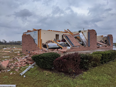
| Brick house destroyed by a tornado Wednesday in Alabama. Photo by Roger Bean |
Those tornadoes and severe storms materialized as forecast, but fortunately, most of the tornadoes seemed to go over sparsely populated rural areas.
It does so far feel like there were slightly fewer tornadoes than some of the expectations, which of course is great.
The result was a fair amount of damage, but so far at least, no fatalities have been reported. Which is actually great news, as a high risk tornado day usually leads to deaths. So far, two injuries have been reported.
Still, social media is showing lots and lots of homes and businesses damaged or destroyed in the tornadoes, so there really is significant destruction.
The hype was justified and I think people did a great job as meteorologists did an equally great job with tornado warnings so people were able to get into their safe spaces.
So far, there are 24 confirmed tornadoes from yesterday, but that number will go up as National Weather Service meteorologists examine damage paths. Additionally, more tornadoes are certainly a good possibility in the Carolinas today.
There certainly was a super-abundance of supercell thunderstorms capable of producing tornadoes in Mississippi and Alabama yesterday. Laurel, Mississippi endured four separate tornado warnings on Wednesday. A warning means a tornado is imminent or occurring. Four separate rotating supercell thunderstorms rolled over Laurel Wednesday. Two of them produced actual tornadoes, but they touched down away from the center of town.
There's evidence of some strong tornadoes from yesterday, too. One brick home was leveled to its foundation, most of the structure and its contents blown far away from where they were before the twister.
The storm system responsible for creating the tornadoes has moved out of Mississippi last night and will be out of Alabama later this morning.
While the threat of tornadoes in the Carolinas today with this storm is not quite as high as it was yesterday further west, it seems inevitable that there will be a few twisters, so it's not done yet.
After today, it doesn't look like there will be any storms that will produce a lot of tornadoes for at least the next week or so.
UP HERE IN NEW ENGLAND
While the South was dealing with tornadoes yesterday we up here in Vermont and the rest of New England enjoyed a gorgeous early spring day.
The parent storm that produced the tornadoes is bringing badly needed rain to the Mid-Atlantic States and as far north as southern New England. In central and southern New England, that rain will switch to snow tonight, mostly just amounting to one to three inches, with a few spot totals a bit more than that.
Up here in Vermont, a cold front was producing a little spotty light rain early this morning. This rain will continue for at least part of the day, but start to end north to south as the cold front sinks south. That will shunt the bulk of that storm system to our south.
South of Route 4, however, that storm will clip that area with additional light rain into this evening, ending as a period of snow. Up to a quarter inch of rain is coming to to southern Vermont.
After that, we get a quick shot of wintry air, the kind we've been getting all month between the periods of spring weather. It'll drop into the single numbers and teens by tomorrow morning. Friday's high temperatures will be at or below freezing, and then we get another early morning Saturday in the single numbers and teens
Then it will warm up, and stay warm for the weekend and most of next week. It'll get well into the 40s Saturday, and daily highs will be in the 50s Sunday through Wednesday.
Since the air mass will be so dry, especially Saturday through Tuesday, nighttime lows will get below freezing, which will keep the maple sugaring going nicely.
This dry air is a problem, though. As I've previously mentioned, it's dry, this month is super dry and the very light rain this morning won't make much of a difference.
With most of the snow melted in the valleys and more snow disappearing in the coming days, last year's weeds, brush and such is drying out. Brush fires are definitely a risk starting as soon as Sunday and continuing into next week.
Luckily, it doesn't look like it will be particularly windy during the upcoming dry weather.

No comments:
Post a Comment