Showing posts with label rare. Show all posts

Saturday, September 13, 2025

Odd Saturday Moment: Rare, Long-Lasting Tornado In Remote Southeast Utah

Navajo Nations Police Department today 
post this photo of a large tornado in 
(checks notes) remote extreme 
southeast Utah. 
Tornado alley in a remote corner of Utah?

An often large tornado spent at least an hour intermittently on the ground around Montezuma Creek in extreme southeast Utah. 

That's very close to the Four Corners, where the borders of Utah, Colorado, Arizona and New Mexico meet. 

The tornado and rotating supercell thunderstorm was still at it around 2 p.m. local time ( 4 p.m. Eastern). It appeared to be crossing the state line and heading into extreme southwest Colorado

The Navajo Nation  Police Department said so far, three homes had been damaged but there were no injuries. 

Police were warning people to say off the roads and to see shelter. The Utah Highway Patrol and San Juan County Sheriff's were en route to the area to help, 

Tornadoes are fairly rare in Utah, as the state averages about two or three per year. However, this part of Utah almost never sees tornadoes. Especially ones as large as this one, and those that last a long time like this twister has. 

San Juan County, where today's tornado hit, also had one back on July 12, said Matthew Cappucci of MyRadar Weather Radar. 

 The area where the tornado hit was only under a marginal risk of severe thunderstorms, a low level alert in which only isolated instances of severe storms were forecast. Tornadoes were not predicted. 

Severe thunderstorms have been expected further south in New Mexico.

An upper level low centered near the storms apparently created enough spin in the atmosphere to support supercells and the tornado.  

The tornado and severe weather hit on what has been an otherwise relatively uneventful weather day in the United States. 

Wednesday, May 28, 2025

ANOTHER Out Of Season Nor'easter About To Strike Vermont/New England. On Saturday, Of Course!

Forecast weather map for Saturday shows 
another rare May nor'easter over New England
the second one this month. Only two 
percent of all nor'easters hit in May, at least usually
Historically, only about two percent of all nor'easters strike New England in May.  Nor'easters are creatures of the winter.  

However, we're about to be hit by the second nor'easter this month. Go figure.

This one will come through Saturday, which of course will by far make Saturday in Vermont the wettest, gloomiest day of this week. It will also be the tenth Saturday in a row with rain.  It's a Vermont tradition!

BEFORE WE GET THERE

Today will be the last truly nice day for awhile, but most of the upcoming days, with the exception of Saturday, won't be a total loss.

It got up to 82 degrees in Burlington yesterday. Summer warmth, but the humidity was rock-bottom low, so it felt pleasant. 

We'll do it again today, with highs at similar levels. Sunshine will tend to fade behind high clouds this afternoon, but it will still be a wonderful day to get outdoors.

Tomorrow, not so much. It should be cooler under a lot of clouds. Showers will roam around Vermont, especially in the afternoon. They won't be heavy, only depositing maybe a tenth to at most a quarter inch of rain.

With the clouds, it'll be noticeably cooler, rising up to only the 65 to 72 degree range.

Friday looks better. At least there will be some sun.  There is a risk of showers, but they should be light and won't last all day, Temperatures should pop back up into the 70s for many of us

SATURDAY NOR'EASTER

Then we get into Saturday. Our nor'easter. If current forecasts hold, it'll pretty much rain all day. It could come down hard at times. It very likely won't be enough to cause flooding, but it will keep our ground super saturated. If there's any flooding, it would be very widely scattered and quite minor. Definitely no big flash floods and damage like we had on Saturday, May 17 with those severe thunderstorms.

We won't even hear thunder with this nor'easter

If this were winter, the storm would take a perfect track to give us a huge snowstorm, But it's the very end of May, so rain it is!  Unlike last week's nor'easter, it won't even be cold enough on mountain summits for snow.

Still, it will be cold for this time of year for us valley dwellers, with highs only near 60.   

This nor'easter will also be "better" than the last one for another reason. It won't linger around obnoxiously for days like last week's storm did. It'll zip on through, and be pretty much out of our hair by later Saturday night. 

BEYOND SATURDAY.

The nor'easter will be somewhere around central Quebec Sunday, whipping chilly north winds and showers down on us during the day. So it will be quite a chilly first day of June, with highs only in the upper 50s and low 60s.  Those showers should be light, but perhaps frequent, though it won't rain all day. 

The storm will be further north Monday, but still close enough to keep it chilly for June and give us the risk of some scattered light showers.

But after that, the nor'easter will be a memory. Forecasts of course are iffy in the long term, so we can't get into specifics. But it does look like we're in for a dramatic warm up starting Tuesday and continuing on for the rest of the week. 

Sunday, May 11, 2025

Vermont Enjoying Its First Dry Day In Ages Today, To Much Wet Out There Anyway

After a gloomy few days, evening sun Saturday lit
up this flowery branch in St. Albans, Vermont. Look
close and you can see a spider web in the upper
right.  After an incredibly soggy start to May,
Vermont is about to be treated to a stretch of
dry, sunny weather. 
 It was such a pleasure this morning going outside amid bright sunshine, and a fresh dry breeze this morning in St. Albans, Vermont.  

Today will be the first rainless day since April 30.  Since March 19, there have only been ten days that have been precipitation-free, so today really is a treat. 

At least we can say that the drought we had last fall that lingered to some extent into the winter is over. 

In the first ten days of May, southern Vermont in particular has had more rain than we usually see during the entire month.

For instance, Rutland has had 4.05 inches of rain since May 1. The entire month of May there should have 3.63 inches. Woodstock has had 4.66 inches of rain so far in May, an inch more than what should come down there in all of May. 

We're actually fortunate to be getting a break in the rain. Things are so soggy that one more good rain storm might have triggered flooding worse than the minor stuff we saw Saturday. 

As it was, some of the minor flooding in Vermont was actually a little worse than forecast.  The Otter Creek at Center Rutland, Vermont reached 10 feet yesterday, which put it on the border between minor and moderate flooding. The crest was two feet higher than forecast and flooded some low lying roads in the area.

A section of road in Pomfret, Vermont is closed this weekend due to a mudslide. 

Further north, the Winooski River at Essex Junction stopped just a few inches short of flood stage. 

RAIN SHUTS OFF

Vermont is not going to see any rain of note until Wednesday or Thursday at the earliest.  Even then, it will be in the form of just scattered showers and thunderstorms. It won't be until Friday when we see a shot at any substantial, widespread rain in the Green Mountain State. 

Today, Mother's Day, will be the last genuinely cool spring day we'll see for awhile.  Don't get me wrong, the weather today is delightful. But it is brisk for the season out there.  Highs should only get into the 50s, with some low 60s south. The fresh north breeze should continue all day, keeping things feeling cool. 

But set yourself up outdoors out of the wind and in a sunny corner and it will feel nice. 

As I have been advertising for days, we have a week of at least sort of summer coming up. Every day from Monday through Saturday will get at least into the 70s, and I think we'll see some low 80s thrown in there from time to time later in the week. 

Tonight - as you can imagine - will be chilly, and I wouldn't be surprised to hear of a patch or two of frost away from Lake Champlain. Nothing widespread, though. 

After that, we'll have mild nights to go along with the warm days. With all the moisture in the ground now and the balmy temperatures, Vermont's forests will continue greening up fast, and your garden plants will be growing like crazy.

Of course, all the wet means the black flies are going to be awful for the rest of the month, too. And the mosquitoes aren't far behind.  

At least the strong May sunshine will make things less squishy underfoot as we get through this week.  I guess we finally get to enjoy spring. 

Tuesday, June 11, 2024

Hurricane Season Beginning, As Fate Of Landmark Hurricane-Trashed Louisiana Skyscraper Is Sealed

The Capital One Tower in Lake Charles, Louisiana will
be demolished later this year after sitting abandoned
and seriously damaged for four years after Hurricane Laura.
At around 1 a.m. August 27, 2020,  Hurricane Laura smashed into the coastline of of southwestern Louisiana as a powerful Cat 4 hurricane with winds of 150 mph. 

It was the strongest hurricane to strike that section of coastline since records began in 1851.

As you can imagine, coastal towns and cities like Cameron, Sulfur, and Lake Charles in Laura's eyewall, where the winds were strongest suffered catastrophic damage. 

One of the iconic images after the hurricane was the Capital One Tower, the tallest building in Lake Charles. A majority of its green reflective glass windows were blown out. Most of the offices inside were badly damaged or destroyed.

The building oddly has just sat there, wrecked and untouched ever since the hurricane blew threw nearly four years ago. Now, something that seems like a bit of a waste, the Capital One Tower is going to be torn down.

According to local news reports:

"Following a long battle between the owner, Hertz Investment Group and its insurance company, and many attempts to find a developer to restore the tower, Mayor Nic Hunter announced that the "eyesore" will likely be torn down late this summer.

'Ultimately, private industry was not able to save this building," Hunter said" 

Although floods, hurricanes and tornadoes routinely destroy buildings, it's rare, maybe unprecedented for entire skyscraper to completely fall victim to a storm.

This building was completed in 1982 and went through a bunch of name changes before becoming the Capital One Tower not long before Hurricane Laura. 

The 22-story building was completed in 1982.  After the hurricane, there was a long insurance process. A bit of repair work was started, but then it was announced the building was up for sale. Nothing came through.

Mayor Hunter said through the building was iconic, it kind of started to outlive its usefulness for downtown Lake Charles even before Hurricane Laura. He'd like to see the area redeveloped in a way that brings fresh energy to the city. 

A large parking garage on the site will remain. A boatload of communications equipment atop the skyscraper that's still servicing the Lake Charles area will need to be moved before demolition.

 The closest other example I've seen to a skyscraper being torn down from storm damage was The Tower, a 35-story building in downtown Fort Worth, Texas.

Fort Worth was hit by a powerful tornado in March, 2000.  Most of the Tower's windows were blown out, and the interior suffered extensive damage. Water damage from ruptured sprinklers made it worse, and black mold developed. 

The Tower was still structurally sound, but the damage was so great that developers decided to implode it. But costs and dangers to that idea became prohibitive. 

A developer ended up buying the Fort Worth building and converted it into luxury condominiums. 

A 20-story Tulsa, Oklahoma high rise was heavily damaged in a 2017 tornado and sat vacant for several years. Like the Fort Worth building, it was sold and redeveloped into luxury apartments. Residents started moving into the building this year.   

Recently a severe storm blew out hundreds of windows in Houston skyscrapers, but those buildings are expected to be repaired and reopened if they haven't already.    

Saturday, May 11, 2024

Northern Lights Delights Millions Of People, Including Southerners, Vermonters

 Wow! What a show!

I was able to catch this image over St. Albans, Vermont
with an old iPhone5.
Much of Planet Earth was treated to a spectacular show of aurora last night, as the most intense geomagnetic storm from the sun in decades caused a massive display in the skies. If you went outside in Vermont last evening as I did, you surely saw a treat. 

The aurora is normally a creature of the far north. But Friday night, denizens of such Arctic outposts as Tybee Island, Georgia, San Antonio, Texas, Orlando, Florida and Nassau, The Bahamas found themselves enjoying the nighttime display. 

Take a look at your social media. It's FULL of photos this morning of the aurora.  If you really want some great Vermont images, check out photographers Adam Silverman, Stephen Mease and Brian Drourr

There are surely other Vermont photographers that I'm inadvertently skipping that also have amazing images.

Here in Vermont, it was the second extreme and breathtaking event in the skies within about a month, and on both occasions the weather cooperated. That's something rare in this cloudy state.

Back on April 8, northern Vermont was in the path of a total solar eclipse. High clouds that moved in just prior to the eclipse did nothing to block the spectacle, but did add some color and texture to what was already a breathtaking event.   

Old iPhone5 capture of the show last night over 
St. Albans, Vermont. 

Last night, skies partially cleared in Vermont, especially in the north, just before sunset. Like during the eclipse, the remaining clouds added texture to the curtains of green and red dancing in the sky. 

The aurora was so far south that it seemed to be originating right overhead. For a time here in St Albans, there was a dark circle directly overhead with streamers and sheets of green and red light emanating from it in every direction. 

Incredibly, the aurora covered the whole sky from northern to southern horizon.  That's only the second time in my long life I've seen anything like that. (The first time was during an outdoor birthday party my sister threw for me on September 7, 2002. Nice gift!)

Last night, the color changed constantly and so did the quality of the show. Sometimes it was just a general green or red glow in the sky. Other times, brilliant streaks lit up the night. 

At one point a shooting star zoomed through the spectacle, adding just that much more to the show. At another point, it got spooky. Most of the sky glowed a blood red, which reflected on the landscape surrounding me, making it seem like everything was red.

At one point last night, the sky over St. Albans turned
a spooky blood red. 
Since the aurora wasn't limited to a narrow path like the eclipse was, we had no stampede to Vermont to witness the show. Still, popular viewing spots got busy. 

 The Route 2 causeway between Milton and South Hero over Lake Champlain was reportedly jammed with hundreds of people, as that location offers a spectacular, clear view to the north. And in the case of what happened last  night, to the south, too.

The strength of the geomagnetic storm that caused all this could have created disruptions, such as power failures, internet outages and long lasting GPS short circuits. So far, though, I've seen no reports of any major issues. 

The only casualty I could find was our Jackson the Weather Dog here in St. Albans. He was a bit traumatized and confused because Jeff and I turned off all the exterior lights on our house and stood in the driveway, staring at the sky. 

The geomagnetic storm is continuing, so much of the planet might see another aurora tonight. It probably won't be as widespread as last night. 

Here in Vermont, we'd have a shot of seeing something somewhat less spectacular than last night, but still worth staying up for. However, the forecast is cloudier than it was last night. 

This has been quite a year for Green Mountain State skywatchers. Next up is not space weather, but regular weather. 

We're heading into thunderstorm season, which to me creates the most beautiful and interesting clouds possible. No thunderstorm outbreaks are in the immediate forecast, though it will be showery off and on today through at least Wednesday. 



Thursday, August 17, 2023

Southern California Has A Chance Of Getting First Tropical Storm Since 1939

One forecast for the path of Hurricane Hilary. If it arrives as an 
intact tropical storm by the time it reaches California,
it'll be the first time since 1939 that's happened. 
It never rains in Southern California, goes that old song from way back in 1972.

The song is actually partly true. It almost never rains in southern California, at least in the summer. If it does rain during the summer, it's scattered and brief and doesn't amount to anything. 

Or not. 

The coming days could well be an exception to that no rain rule.  A tropical storm, or at the very least its remnants, appear poised to blast much of California, including, or even especially southern California in the coming days. 

The culprit is Hurricane Hilary, which was rapidly gaining steam today well off the central Mexican west coast. It has top winds of 105 mph and is expected to strengthen rapidly. 

Most hurricanes that form near the west coast of Mexico or Central America usually either hit the southern or central west coast of that nation and quickly die, or the bash into Baja California and wind down quickly there. Or even more often, they head northwest and fall apart in the chilly Pacific Ocean waters southwest of California.

A few of these Central American or Mexican-born storms launch long journeys westward into the central Pacific Ocean roughly toward Hawaii, as the recent "Dora the Explorer" hurricane did this month. 

This isn't the case with Hilary. Steering currents are bringing it northward toward the long Baja California peninsula. If Hurricane Hilary makes landfall into Baja California, it'll fall apart, but still give the southwestern United States heavy rain and flooding over the weekend or early next week.

If Hilary stays just off the west coast of Baja, that's a different story.  The water is cold off of Baja and southern California. Hurricanes hate cold water, so they weaken when they encounter such conditions. 

However, Hilary will be a strong hurricane on approach.  So it'll take awhile for it to weaken as it comes toward California. Plus the cold water off the coast isn't nearly as chilly as it usually is. That's  thanks in large part to the current El Nino, with an assist from climate change. So that would slow the weakening process too. 

If Hilary is still an intact tropical storm by the time it lands in California - an iffy but still real possibility, it'll be the first time since 1939 that a tropical storm has hit California. (There have been other instances in which former hurricanes and tropical storms have unleashed flooding and locally damaging winds hit California, but this is after they transitioned to non-tropical storms).

The September, 1939 tropical storm dumped 5.62 inches of rain on Los Angeles and more than 11 inches on Mount Wilson, California.  Winds gusted to 65 mph in parts of southern California.  

Storm surges devastated Long Beach and other coastal communities.  A total of 45 people died in that storm. 

A hurricane or strong tropical storm is also believed to have struck southern California in 1858.

The 1939 hurricane hit under similar conditions to today. A strong El Nino was in progress. An intense heat wave scorched southern California in the days leading up to that storm. A strong heat wave is now hitting parts of that region.

Whether or not Hilary maintains itself as a tropical storm by the time it reaches California, heavy rain and flash flooding now seem almost inevitable.  At least scattered areas of flash flooding, but probably more, are in the forecast for much of California starting Saturday and continuing through Sunday and into early next week. 

Remember that song I mentioned at the top, how it never rains in Southern California?  I think a lyric from that song is about to come true: "But girl, don't they warn ya: It pours, man it pours."

Wednesday, May 17, 2023

Rare Asperitas Clouds Announce Frigid Vermont Cold Front, Freeze Warnings Coming For Tonight

Relatively rare Undulatus Asperitas clouds over 
St. Albans, Vermont Tuesday. These preceded a 
cold front that will give us a nasty spring
freeze tonight. 
 Our big cold front that came through yesterday did manage to give us weather nerds a treat. 

Rather rare Undulatus Asperitas clouds appeared overhead, just ahead of the cold front. 

This is a "new" cloud in that they've only gotten their own meteorological classification in 2015, when the World Meteorological Organization agreed to classify this previously poorly documented cloud.

Us weather geeks get pretty wound up when we see these clouds because they're pretty rare, and nobody agrees on how they form, unlike most other cloud types. 

You need unstable air to create these clouds, but the air is often unstable. In most cases, those clouds don't form. For some reason on Tuesday, they appeared.

As the British Met Office tells us, many scientists think they are associated with thunderstorms. However, the  Asperitas clouds   have been spotted often enough when no thunderstorms were nearby.  Yesterday in Vermont  was an example. No thunderstorms were nearby when they appeared. 

The clouds are often associated with rain, and a few light showers came through not long after they appeared. Video of these clouds from Tuesday is at the bottom of this post. 

THE COLD FRONT

That cold front meant business yesterday, Temperatures in some parts of Vermont crashed by 20 degrees in an hour. Ahead of the front, temperatures were near 70. A little behind it, readings were in the mid and upper 40s. 

Temperatures continued to drift down overnight and by this morning, some people were near freezing. I noticed a bit of ice on my truck in St. Albans, Vermont early today. 

It will not warm up much today, with highs in the 45 to 52 degree range with gusty north winds. 

There's still a wildfire hazard today. The cold front deposited very little rain, and some places didn't get any at all. An overcast over northern Vermont early this morning should break up later. In the meantime, I wouldn't be at all surprised if a few places are seeing a snow flurry or two this morning. But that won't amount to anything. Thank goodness for that. We don't want a snowstorm. However, rain would be nice, and it's not in the cards. 

Very dry air and those gusty winds will ensure the underbrush out there remains pretty parched. Any fires that start could spread really fast, so be aware and be careful with any flames. 

The Vermont Department of Forest, Parks and Recreation rates today's fire danger as very high, which is a pretty rare designation covering the entire state. 

THE FREEZE

If anything, forecasts for tonight's subfreezing temperatures have gotten a little worse. Above freezing temperatures will probably be limited to the immediate shores of Lake Champlain. By the time you read this, the National Weather Service in South Burlington will have issued a freeze warning for the entire state except the Northeast Kingdom.

The NEK is not in the warning because the growing season is not considered to have started yet out there. 

If you haven't done so already, bring your sensitive plants inside. I do worry that in some colder areas that already have leafed out trees, those leaves will get damaged. That would leave things looking pretty ugly into June, as we'll have to wait until blackened and wilted leaves are replaced by new ones,

This won't be a widespread problem, but I wouldn't be surprised to see a few spots have this issue.

Temperatures also now look marginal for fruit crops in the Champlain Valley.  As I said yesterday, blooms on apple trees can hang in there if the temperature stays above 29 degrees. Other fruit crops can survive temperatures down to about 30. It will be close in some areas. 

Thankfully, it will rapidly warm up during the day Thursday, with temperatures bumping up into the 60s. 

We can hope for some rain this weekend, but unfortunately, it doesn't look like much.  There's another chance of frost early next week, but that still looks less widespread or as intense as tonight's freeze.

VIDEO:

Here's a video I shot of the asperitas clouds over St. Albans, Vermont on Tuesday. Part of the video even features a guided tour of the clouds courtesy of a hawk.  End of the video shows cold wind gusts that dropped the temperature from about 70 to 50 in a little over an hour. If you don't see an image below, click on this link to view the video. Otherwise, click on image below to watch: 


Sunday, July 3, 2022

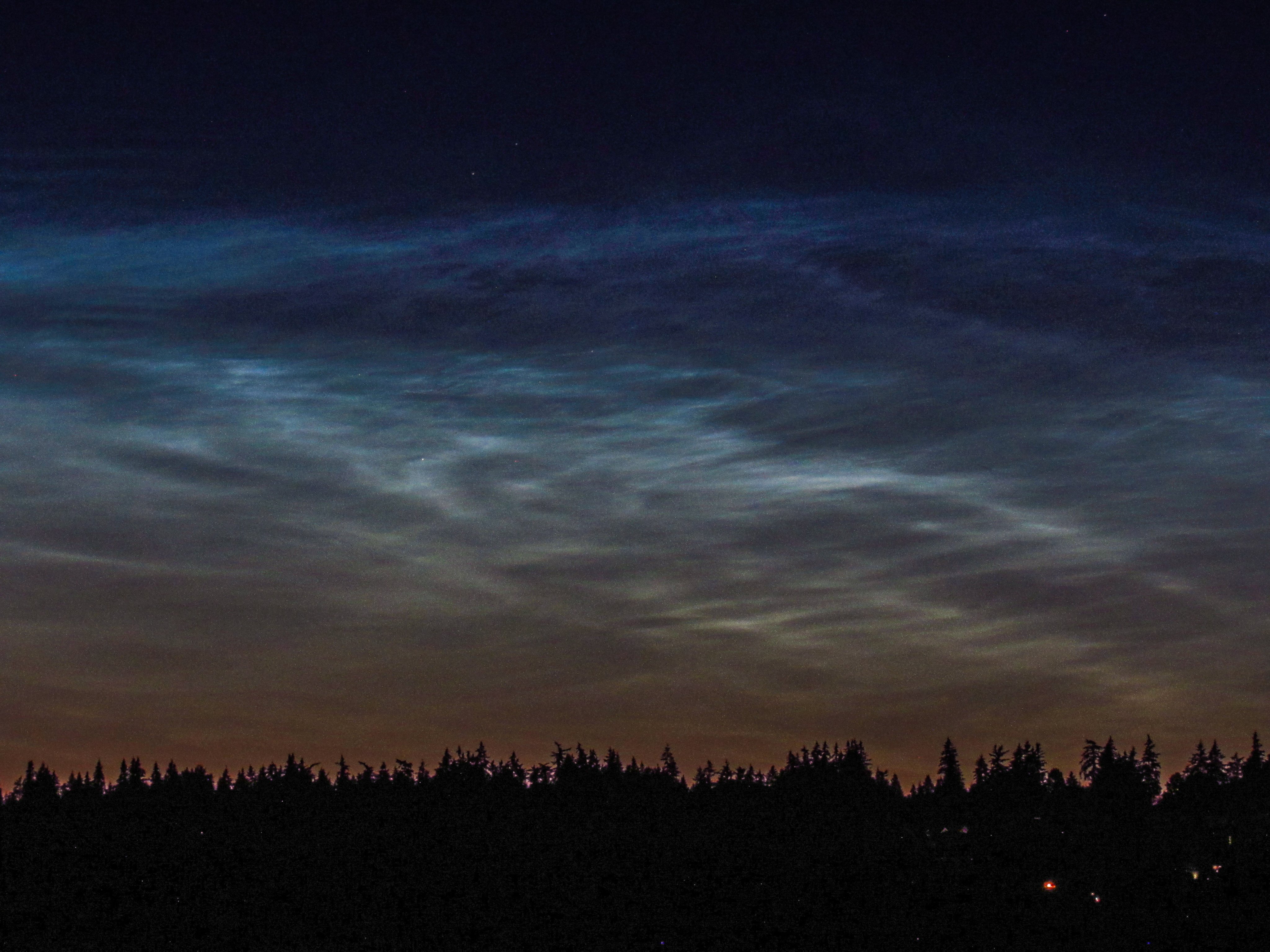
Be On The Lookout For Rare Noctilucent Clouds.

Meteorologists at the National Weather Service office
in Seattle, Washington took this photo of beautiful,
eerie and rare noctilucent clouds last week
 If skies are clear enough for the next few nights, take a look toward the north after dark. 

There's been an outbreak of rare noctilucent clouds, an eerie, beautiful blue glowing wispy cloud that is as high in the atmosphere as you can get. 

They're most likely to be seen near the poles in the summer. In early summer, they're sometimes visible in places like northwestern England, Canada, Alaska, that sort of thing.  Sometimes people in the northern United States get to see them. This year, they've been the most pronounced in decades.

Here's how the Washington Post explains these clouds:

"Noctilucent clouds, also known as polar mesopheric clouds, appear during the summertime in each hemisphere at about 50 miles high in the layer of the atmosphere knows as the mesosphere. They form when water vapor congregates around specks of meteor dust floating in the mesosphere and freezes, forming ice crystals."

They're usually visible not long after sunset and before sunrise. The clouds are so high up they are illuminated by the sun that has, at ground level slipped below the horizon. It looks like it might be clear enough tonight to go out and take a look toward the north,  just in case these clouds appear.

The Washington Post said there's a clear reason why this has been such a good year for noctilucent clouds. The mesosphere is an incredibly cold, dry place. There's little moisture up there to work with. But for some reason, at least by the standards of the mesosphere, it's wet up there. 

Another shot of the noctilucent clouds over Washington
State last week taken by NWS personnel.

Nobody is sure why. Perhaps it's rocket launches. There were 16 launches in June. It could have been the It could have been the huge Hunga Tonga volcano eruption back on January 15, which put a remarkable amount of stuff high in the atmosphere. The eruption could have dragged some moisture from the Earth's surface way up to the mesosphere.  It's so high up that I doubt climate change has anything to do with the increase in these clouds. 

Sky watchers are certainly excited about these clouds now.  Last week, the National Weather Service office in Seattle, Washington urgently tweeted that anyone who was awake at that late hour should head outdoors to see what they regarded as the best display of noctilucent clouds in decades. 

They had the photos to prove it, too. Other spectacular sightings of these clouds have been reported this past week over places like British Columbia, Denmark and Great Britain.

This won't last long.  As the days slowly start to get shorter, the chances of seeing these beautiful clouds begins to diminish. 

Saturday, July 3, 2021

Two Tornadoes Struck Washington DC Thursday Evening

Screen shot of the U.S. Capitol as a tornado passed nearby
Thursday evening.
 I'm really hoping nobody was on the famed Mall in Washington DC Thursday around 9 p.m.

A rare tornado swept in from nearby Arlington, Virginia to near 16th Street and Constitution Avenue NW, and into the Mall, according to the National Weather Service office in Baltimore/Washington.

Damage was pretty extensive in Arlington, where a man was hospitalized after the tornado tossed a tree onto his house, collapsing the porch. Trees and power lines were downed a greenhouse was trashed and a shed was leveled. Many homes had relatively minor damage, including shingles and clapboards ripped from roofs and walls.  

The tornado continued into Washington DC, and onto the Mall. It passed less than a mile from the U.S. Capitol, White House and Lincoln Memorial. In fact the end point of tornado damage was on the south end of the Ellipse, which is basically next to the White House.

The tornado uprooted and broke numerous trees in the Mall. Fencing erected for this weekend's Fourth of July celebrations were toppled and move and mangled, so that will have to be hurriedly fixed today. 

For comparison, same web cam as above when the weather
is clear, without a tornado
This EF-1 tornado had maximum winds of 90 mph and carved a path that was 4.4 miles long and up to 125 yards wide. 

By no means huge, this tornado was still larger and longer-lasting than many reported across the United States annually.  

Tornado warnings went up ahead of the storm and it seems most people took shelter. There was just that one injury in Arlington. Still, there was disconcerting video on social media of people in the Lincoln Memorial as the tornado passed close by.  

A second, weaker, more brief tornado touched down for a short time a mile northeast of the Capitol. It had top winds of 80 mph and traveled just three quarters of a mile before lifting.

According to the Washington Post, tornadoes are relatively rare in DC, but do happen. There have been three tornadoes in the district since 1950, the most recent in 2017.  That one caused some damage around the Tidal Basin, right near where Thursday's tornado touched down. 


Monday, January 18, 2021

Off The Rails. Wildfires Still Loom In California During "Wet" Season

Wildfire burns in southern California last week. This
is normally a wetter time of year in this state, and
winter wildfires used to be rare. Not anymore. 
 It's happening again.  

Once again in the normally wet California month of January, they're worried about wildfires again. 

The winter rains have largely failed to materialize so far.

This week, an actual storm is forming near California.  Too bad it's in a weird place south and east of California - in Mexico and eventually into Arizona and Mexico.

The storm, and high pressure north of it, will create lots of wind early this week in California. Which means the threat of more fires. Which is really weird or January.

The hills could easily come alive with blazes in and around Los Angeles as the winds ramp up today and tomorrow. Even more remarkably, there's a fire danger all the way up into places just east of San Francisco and near Sacramento.

This part of central California is normally pretty sodden this time of year.  Not this year. San Francisco has only had a half inch of rain so far this month. At this point in January, they should be closing on 2.5 inches for the month. Sacramento, California has only scraped together a quarter inch of rain so far this month, against a normal of two inches by now. 

So, we could see the probably unprecedented spectacle of a wildfire in or near California wine country in January.  Though not as likely as fires in southern California, it's possible. Red flag warnings for fire risk are already in effect for parts of  central California. 

Winter wildfires are becoming a thing in California after being exceedingly rare, historically.  Climate change seems to be contributing to historic droughts and winter heat.  Another bout of record heat hit parts of southern California over the weekend.

Even without the fires, the wind is likely to cause some damage in California. 

Tonight and tomorrow, winds could gust as high as 90 mph in the mountains east of Los Angeles and as high as 65 mph near the coast. That'll be enough to toss down trees and power lines, an even cause structural damage.

Further north, the Sierra Nevada range and surrounding areas are in for a big blow as well.  The wind is expected to stir up three to six foot waves on Lake Tahoe, which would damage shoreline property. 

Toward the end of the week, a little rain might finally fall across most of California, but amounts look pretty unimpressive.  One glimmer of hope is the forecast of some above normal rainfall there at the very end of the month.

I'm sure everyone out there is hoping for that! 

Tuesday, November 24, 2020

Somalia Hurricane; Cape Cod Tornado Alerts: Two Weird Storms

Satellite view of Tropical Cyclone Gati striking
Somalia on Sunday. 
Hurricanes don't hit Somalia.  Tornadoes don't threaten Cape Cod in November. Until now, apparently. 

This past week, Somalia, in Africa, got hit by a compact, but powerful hurricane. 

As NPR reports:

"Tropical Cyclone Gati made landfall in Somalia on Sunday with sustained winds of around 105 mph. It's the first recorded instance of a hurricane - strength system hitting the country. At one point before landfall, Gati's winds were measured at 115 mph." 

This is the strongest tropical system on record in the norther Indian Ocean, and furthest south in the Indian Ocean. Tropical systems sometimes hit further north in Yemen and Oman, but not Somalia. 

Tropical Cyclone Gati also holds the record for the fastest intensification rate for any hurricane type storm in the northern Indian Ocean, with winds ramping up from 40 mph to 115 mph in just 12 hours. 

I have to say this seems consistent with climate change.  Warmer ocean water is fuel for tropical systems.  As larger areas of ocean water become warm enough to sustain hurricanes, chances are new places can be hit, and places that do normally see hurricanes are at risk for stronger ones. 

NPR reports:

"'With climate change were seeing warmer ocean temperatures and a more moist atmosphere that's leading to a greater chance of rapid intensification for tropical cyclones like Gati, meteorologist and climate journalist Eric Holthaus told NPR. 'Gati's strength is part of that broader global pattern of stronger storms.'"

As Gati was developing, it was small in area and came across an area of very light upper level winds, which allowed it to strengthen over warmer than normal Indian Ocean waters. "

 Tropical Cyclone Gati hit the northeastern corner of Somalia, a desert area that normally gets just four inches of rain per year.  Gati was expected to dump twice that in just two days. 

At least eight deaths were reported with Gati.  Widespread flooding hit much of Somalia, and wind damage was severe near where Gati made landfall.  

CAPE COD TORNADO WARNINGS

Tornado warnings went up for Martha's Vineyard and Cape Cod in Massachusetts Monday as a rotating thunderstorm swept through the area.  The scary weather was part of a storm system that was just starti to rapidly develop.

This storm brought widespread downpours and thunderstorms to New Jersey, the New York City area and southern New England as it organized. (Vermont got light rain and snow out of this). 

Possible funnel cloud over Cape Cod Monday during a 
tornado warning. Photo by Bart Jarek

Sometimes, the initial formation of what eventually becomes a strong storm can set off severe weather and even tornadoes. That type of thing, however, rarely happens this time of year in New England. 

It was the first time on record that the National Weather Service office in Boston saw fit to issue tornado warnings in November. 

I'm not sure if any tornado touched down in Massachusetts. There was briefly vague signs of a debris in the air near Yarmouth, but it's very unclear if that was produced by a tornado or just gusty winds.  Most of the rotation on radar was rather broad, and not tightly wound in small areas.  That broader rotation could well mean no tornado could get its act together and touch down.

People did report seeing a funnel cloud, and minor wind damage was reported on the Cape. 

I imagine the National Weather Service in Boston might investigate the area today.  

The storms did bring 1.5 to 2.5 inches of much needed rain to good sized chunks of southern New England. The rapidly deepening storm departed, bringing gusty winds and heavy rains to the Canadian Maritimes. 


Sunday, August 16, 2020

California Fire Tornado and Vermont Funnel Cloud Is So 2020

This year is as twisted a time in history as possible, so of course it makes sense that on a single day we had at least one fire tornado in California and a rare funnel cloud in Vermont's Northeast Kingdom. 

We'll get into the California tornado first, then the Vermont funnel.  

Rare fire tornado in California
on Saturday

And things kept going this morning, with a rare lightning barrage in San Francisco. We're using that word "rare" in this post a LOT! It's 2020 after all.  

FIRE TORNADO 

The western United States is enduring a record heat wave and a drought. The inevitable result of that is wildfires.  It's so dry and winds are so erratic that we're getting extreme fire behavior out there

Large wildfires sometimes create something called pyrocumulonimbus clouds.   (Say that five times fast!) The heat generated by the wildfires create strong updrafts which create tall, sometimes violent smoky thunderstorms. 

Such was the case in northeastern California on Saturday. 

As Washington Post Meteorologist Matthew Cappucci engagingly explains, that strong pyrocumulonimbus cloud was in an area of wind shear - the wind was changing direction with height. That created a spin. Plus, the atmosphere was primed for updrafts even without the fire.

The updrafts and the changing wind direction with height helped the pyrocumulonimbus cloud to rotate. At times, parts of the rotation tightened and you had tornadoes.

This was a true tornado, not a fire whirl in which the flames get caught in a tight rotation just near the ground. This tornado lowered from the smoky cloud.  It touched down in a fairly remote area, so the actual tornado didn't cause a lot of damage. The wildfire did, of course. 

Fire tornadoes have  happened before, but they are not observed often at all.  If you want a notable example other than yesterday's an area near Redding, California had a massive fire tornado in 2018.

Yesterday's fire tornado in northeastern California is the first known in the United States to prompt a National Weather Service office to issue a tornado warning. 

VERMONT FUNNEL

While all this was going on, Vermont's Northeast Kingdom had it's own twisty excitement.  In this case, it wasn't particularly dangerous, but not something you see in Green Mountain State,  that's for sure.

Like in the fire tornado above, wind shear played a large role in creating the Northeast Kingdom funnel cloud.  Winds were coming from the east at elevations below 10,000 feet, and from the west at elevations above 10,000 feet or so. 

The air flow also tended to converge in the area where the funnel formed, which encouraged its development.

Funnel cloud near Newport, Vermont Saturday. Photo
by Bob Minnie 

There was enough instability in the air to create some showers and thunderstorms, as a pocket of cold air aloft helped clouds billow upward into storms. 

 That chilly air aloft and the spin created what is known as a "cold air funnel" that caused that stir around Newport and Lake Willoughby Saturday evening. 

There were no tornado or severe storm warnings as the parent storm that spawned the funnel wasn't severe. Plus, cold air funnels don't usually make it all the way to the ground.  On some occasions they do and can cause damage, but in this case, the funnel stayed aloft. 

SAN FRANCISCO'S TURN

Cool, stable air created by the chilly waters of the Pacific Ocean tend to help squelch thunderstorms around the San Francisco Bay Area, so they don't see many summer lightning storms. 

But the extreme heat in California, and I think warmer than normal Pacific Ocean water temperatures, helped create a lightning barrage early this morning in the Bay Area.  

Here's that word again: Rare.  

Storms that created funnel clouds over 
Vermont's Northeast Kingdom weakened
as they moved westward, causing this 
fiery sunset in St. Albans, Vermont

Rare severe thunderstorm warnings were issued for much of the central coast of California this morning because of gusty winds associated with the storms.  

The storms didn't contain much rain, so the lightning was particularly dangerous because it could set off more wildfires. The strong, gusty winds associated with the storms didn't help. 

This was just happening as I wrote this, so I'm unsure yet if these storms sparked any wildfires.

Like I said, if you wanted a bizarre year, 2020 is it, for sure!