Showing posts with label aurora. Show all posts

Tuesday, January 20, 2026

Sort Of Cold Today In Vermont As We Await Severe Weekend Arctic Blast

"Planet Claire" style skies over West Rutland, Vermont
during last evening's northern lights display. Photo by Brent
Barnett via Meteorologist Jess Langlois/Facebook

 
 It really wasn't quite as cold this morning as I thought it might be here in Vermont, which is great news, considering what's coming.  

I hope you didn't miss it, but skies partly cleared last evening, so a lot of us got to see the northern lights. 

Viewing from the naked eye, it looked like the northern half of the sky over St. Albans had a pink haze. It almost made me think we were on the B-52s' Planet Claire.  "Planet Claire has pink air....."

Most of us started the day in the teens, which was actually a smidge above normal. Those readings won't go anywhere today. We'll stay right there in the teens. 

Tonight will get down into the single numbers above zero for the most part. The cold hollows might sneak a degree or two below zero. Banana belt towns might hold closer to 10 degree for so.  No biggie.

We've got one more brief warm up coming in before the bottom drops out of everything. The upcoming "warm" spell won't really feel that way since winds will be gusty most of that time. Wind chills ruin everything. 

Tomorrow will get into the 20s on increasing south winds. Tomorrow night will hold in the 20s as those south winds get stronger. The Champlain Valley could see gusts to 40 mph or so.  Nothing earth shattering, you'll hear the roar in the trees

The balmy day will be Thursday when many of us will hit the low 30s ahead of that Arctic cold front blasting out of Canada.

We won't get much snow out of what will essentially be a series of cold fronts. Some of us, especially in the northern Green Mountains, can expect some scattered snow showers tomorrow.  We'll have even more snow showers Thursday, and a couple towns might see the snow come down pretty hard, but really briefly. 

Between now and Thursday night, most of us will get less than an inch of snow. The Green Mountains could score a couple of inches.

COLD WAVE

I'm sort of burying the headline hy waiting until now in this post to talk about the Arctic cold that's coming. But it's still three days away, and it's easier for me to do things chronologically. Sue me. 

We will however, go from the above mentioned Planet Claire to bone chilling former Planet Pluto.

Well, OK, the average temperature on Pluto is minus 387 degrees Fahrenheit, says NASA.  I know we won't get that cold. But this weather wimp will whine that it will feel like 387 below. 

At this point, the cold wave looks like it will be a long slog, with the worst of it coming from Friday night to Monday night. 

The chilliest daytime during this whole escapade will probably be on Saturday. Many towns, especially in northern Vermont will probably stay at or below zero.

If Burlington's high temperature does not make it above zero Saturday, it will be the first time that's happened in four years.  If it stays under zero, that will make it the first time since January, 2018 they've stayed below zero all day. 

The expected low temperatures Saturday night should be mostly in the teens below zero. That'll likely make it the coldest night since February 4, 2023.

A slow warm up should start early next week, but temperatures will stay below normal.  

We'll have more on the cold snap as it draws nearer.

Wednesday, November 12, 2025

Huge Northern Lights Display Delights Much Of Nation; Vermont Gets Glimpses Between The Clouds

Photo of Northern Lights peeking
through the clouds over 
Shelburne, Vermont posted to
Facebook by Amanda Delude
A big display of northern lights lit up the skies across much of the U.S. last night as a big geomagnetic storm targeted Earth. 

Tonight might bring another big display. 

The northern lights were seen as far south as Florida, where residents must have felt like they were transported to the Arctic, where northern lights are very common. 

Florida was also experiencing record cold temperatures early this week, too. 

Social media was filled with color images of the sky over locations from Minnesota to Colorado to Texas to Alabama. 

Here in Vermont, our usual overcast skies prevented much of a northern lights view in many areas  But the aurora was so spectacular you could sort of see it through the clouds. The overcast north of my St. Albans, house definitely had a green cast. 

Near Lake Champlain and in parts of southern Vermont, there were breaks in the clouds that offered glimpses of the show.  Facebook had some great photos out of Weathersfield and Royalton, for example. 

Photographer Adam Silverman, probably the most enthusiastic and best northern lights photographer in Vermont, captured some great images from Malletts Bay, along Lake Champlain in Colchester. 

There were only a few breaks in the clouds, but that was enough. He captured some spectacular shots, like the one he posted on Facebook, that you can see in this link. 

Silverman, ever the fan of nature and skies, wrote: "The sky absolutely burned and glowed with amazing aurora colors, clearly visible to the naked eye. Even the clouds let through enough light to take on surreal hues as they zipped overhead in the stiff, cold breeze."

If you missed any of it last night, people across the northern hemisphere, even at points well south, have another shot at a spectacular show tonight. 

Vermont State Police posted this photo of the northern
lights to Facebook from their Westminster, Vermont barracks. 

 Reports NBC:

"...forecasters at the Space Weather Prediction Center have said the geomagnetic storm could intensity as the 'final and most energetic CME' meaning coronal mass ejection, is yet to arrive and could reach Earth on Wednesday afternoon.

A CME is an eruption of massive clouds of protons, electrons, and magnetic fields from the Sun's outer atmosphere at very high speeds."

Here in Vermont, unfortunately, it's another very cloudy forecast for tonight. The National Weather Service in Burlington predicts about a 96 percent cloud cover for most of the night, which is about as overcast as you can get. The cloud cover declines to 88 percent after midnight, which is still pretty bleak.

Unlike last night, when we had a break in the snowfall, it will very likely be snowing at least lightly overnight across most of northern Vermont.  

Note that the valleys of southern Vermont might have a few more breaks in the clouds than in the north.   

Tuesday, December 31, 2024

Vermont's Biggest Weather Events, 2024: There Were A Lot Of Them

 Once again, 2024 brought Vermont an eventful, often destructive and painful weather year.    
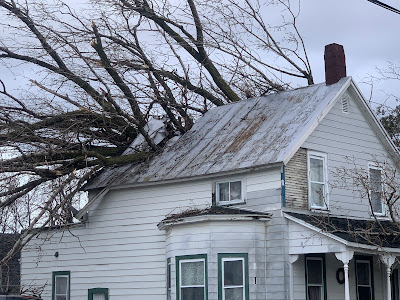
High winds on January 10 toppled a large tree, which
crashed through this St. Albans, Vermont home. 
It will be among the warmest years on record again, much like several previous recent years.  More on that in a post coming along right around New Year's Day.  

The weather extremes of 2024 were all over the place, from wind to floods to drought to heat to cold. Though not that much cold.  The weather often turned destructive, sometimes tragic. 

Weather in Vermont has never been boring. But nowadays, probably because we're in the age of climate change, things are getting even further out of whack. 

Lots of extremes happened in 2024, so let's get into it:  

TWIN WINDS, JANUARY 10 AND 13

Two intense wind storms swept the Northeast including Vermont in mid-January. 

The first of the two hit on January 10. 

Winds gusted to 69 mph at the National Weather Service office in South Burlington, their fourth highest wind gust on record.  Power was cut to 29,000 homes and businesses.

St. Albans was particularly hard hit, with at least three home virtually destroyed by falling trees, with several other houses suffering some damage. 

Along the New Hampshire and Maine coasts, the storm and wind generated a huge and in some case record storm surges which caused massive damage. A new storm a couple day later made everything there even worse 

That second storm hit on January 13, especially along the western slopes of the Green Mountains, where winds topped 80 mph in some spots. The wind blew the roof off a house in Richmond, and fallen trees again blocked numerous roads. Power outages in Vermont again reached a peak of about 29,000 customers. 

FEBRUARY

Another warm winter month. Record warmth on February 9-10  and 27-28 contributed to an average February temperature of 30.2, the third warmest on record. The high temperature of 65 degrees on February 28 would have been the hottest on record in Burlington if not for recent, even bigger February hot spells in 2017 and 2018.

BIG APRIL 3-5 SNOWSTORM
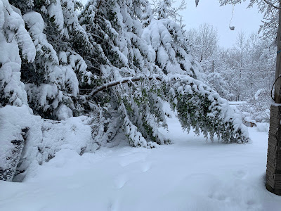
Damaged trees after 16 inches of wet, heavy snow
fell on St. Albans, Vermont in early April. 
One of the biggest April snowstorms on record blanketed the entire state. Biggest snow totals included 24 inches in Moretown in Killington, 21 inches in Underhill and Eden, and 20 inches at Brookfield and Stowe.

Burlington had 10 inches of snow on April 4, its third snowiest April day on record.

The snow was wet and heavy, causing widespread tree damage and power outages. 

VERMONT ECLIPSE GOOD  LUCK

Northern Vermont was in the direct path of the Big Solar Eclipse Of 2024.  It was widely expected that few of  us would see it, as on average we'd have an 80 percent of overcast skies that time of year. 

Instead, the Green Mountain State was blessed with fair skies. There was a broken layer of very thin, high clouds, but that augmented the experience by adding some odd sunset style colors to the sky during the big event. 

We had a second episode of celestial good luck when one of the biggest, brightest most extensive northern lights display graced much of the northern hemisphere as far south as Cuba on the night of May 10.

Though skies had been forecast to be mostly cloudy, most of the night ended up mostly clear in Vermont, allowing for great viewing of the rare event. 

JUNE 18-20 HEAT, STORMS

 Brief but intense heat wave, accompanied by severe thunderstorms in some areas. North Springfield had daily highs during the period of 98, 99 and 101. Union Village Dam in southeastern Vermont had 100 degree highs on two consecutive days. 

Flash flooding in South Burlington, Vermont following
intense storms on June 23. Some of the storms 
prompted tornado warnings, but none were known
to have touched down in Vermont. 

Burlington reached 96 degrees on June 19.  The low temperature that day in Burlington was 80 degrees, tying the record for the warmest overnight low of any day in more than 120 years of records.  

The heat was accompanied by strong storms in some parts of Vermont. After reaching 93 degrees on June 20, Burlington had about an inch of rain within 15 minutes with a storm wind gust of 48 mph.

 Trees came down in Burlington and Stowe, as a precursor to even bigger storms a few days later.

JUNE 23 TORNADO ALERTS AND FLASH FLOOD

A stalled warm front just to the north and an incoming cold front, combined with very humid air set the stage for a severe weather outbreak on June 23.  Forecasters had called for a risk of tornadoes, and in fact a handful of tornado warnings were issued in Vermont as radar showed notable rotation.

Wall clouds and possible funnels were reported, especially near Monkton, but no tornadoes are known to have touched down. There was some tree and power line damage from winds, but that damage appears to have been caused by straight-line winds. 

However, the supercell thunderstorms contained intense downpours, and the two strongest followed roughly the same path across north-central Vermont. The result was flash flooding, the worst of which hit around Stowe and areas around the Worcester Range. Washington County was subsequent declared a federal disaster area due to the flash flood damage.

This flash flood was just a foretaste of what was to come. 

JULY 10 FLOOD DISASTER

Another stalled warm front, and the remnants of Hurricane Beryl caused a new extreme flash flood disaster on the exact anniversary of a similar calamity that hit exactly a year earlier. 

A tractor fell into the ravine created by this road
washout near Hinesburg,  Vermont on July 10.
Unlike the 2023 flash flood, which hit most of Vermont, the July 10, 2024 was mostly focused on northern and central Vermont.  Rainfall totals were as high as nearly seven inches in Hinesburg.

Two deaths were reported in the storm, one in Lyndonville and the other the Peacham. 

This disaster re-flooded homes and businesses damaged in the flood the previous year. Hundreds of roads and bridges suffered significant damage, and as of the end of this year, not all the repairs had been completed yet.  

Some of the more dramatic incidents during this disaster included an apartment building that was mostly swept away in Plainfield. The building's occupants evacuated shortly before the the structure collapsed. 

To nobody's surprise, large swaths of Vermont were declared disaster areas.

The disaster was preceded and followed by oppressive hot, humid weather, which slowed post-disaster cleanup. Lebanon, New Hampshire had a record 12 consecutive days in the 90s from July 6-7. It was Burlington's third hottest July on record. 

EXTRME NEK FLASH FLOOD JULY 30.

Early morning thunderstorms on July 30 dumped an incredible amount of rain in just a few hours in large parts of the Northeast Kingdom. St. Johnsbury received eight inches of rain in just four hours, which is the amount of rain that normally falls there in the summer over the course of two months. 

The resulting flash flood washed away houses in Lyndonville and other towns, but miraculously no deaths were reported. 

But there were close misses. One woman was rescued by neighbors after her house fell into a raging river with her inside it. Two elderly women, one age 98, and their dog, were pulled through their bedroom window by neighbors after their home floated onto a road and thankfully got stuck there instead of washing away and completely disintegrating. 

The storm was highly localized. The eastern end of the town of Danville had 7.4 inches of rain. Another location in the western part of the same town just six miles away received just under an inch of rain. 

A weak upper level low pressure system drifted northwestward into New England and stalled for a time over the Northeast Kingdom, causing the extreme downpours. 

DEBBY REMNANTS CAUSE WIND DAMAGE 
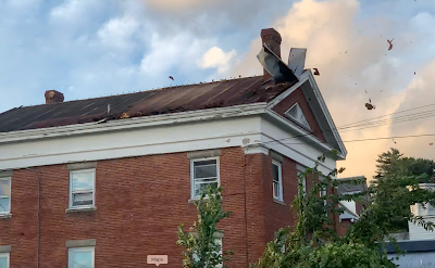
High winds associated with former Hurricane Debby blew
the roof off this building in St. Albans Bay, Vermont. 
The remnants of Hurricane Debby swept over Vermont on August 9, causing a surprisingly strong wind storm that evening. Burlington gusted to 62 mph.  

In Alburgh, a large falling tree crushed a house, trapping a resident inside who was later rescued. The roof blew off a house in St. Albans Bay. 

Numerous roads across Vermont, especially the Champlain Valley, were blocked by fallen trees and power lines. At one point, 49,000 Vermont homes and businesses were without power. 

LATE OCTOBER/EARLY NOVEMBER HEAT

Summer seemingly did not want to quit in the last ten days of October and the opening week of November..

Burlington tied or broke four record highs from October 21 to 31, including a reading of 77 degrees on Halloween. That was the warmest for so late in the season.  Plattsburgh soared to an unbelievable 83 degrees on October 31. Woodstock reached 80 degrees.

The late autumn heat had a final resurgence on November 6 as temperatures climbed to 75 at Union Village Dam, Woodstock and Bennington

FLASH AUTUMN DROUGHT, FIRES

On October 8, no areas of Vermont were in drought. Just eight weeks later, 70 percent of the Green Mountain State was deemed to be enduring drought conditions. 

The drought created a slew of unusual autumn forest and brush fires across the Northeast, including here in Vermont. The Green Mountain State had its worst fire year since at least 2016, thanks to autumn brush fires. One of the fires burned through 70 acres near Barnard. 

HOT YEAR ENDS ON HOT NOTE 

2024 will be the world's hottest year, and the hottest year on record here in Vermont. The year came to a fitting end with a record heat wave on December 29-30.  The temperature reached 61 in Burlington on December 29 and 60 on December 30, both record highs for the date. 

 

Friday, October 11, 2024

Chilly, Unsettled Weather To Continue In Vermont For At Least A Week

Photo taken near the summit of Killington Mountain
Thursday morning. Yep, it's that time of year when
Vermont's mountains start to see snow. 
 As anticipated, reality has finally hit Vermont as much more average autumn weather has hit in a year that has so far been mostly oddly warm. 

Although we don't anticipate any weirdly cold weather, the chill will probably be the most sustained spell of such weather we've seen in many, many months.

It started in earnest yesterday, as Vermont's summits started the day with a fresh, light coat of snow, and many parts of the state stayed in the 40s all day.

Thursday's high temperature of 52 degrees in Burlington was the nippiest high temperature since April 25.

The cloudiness that contributed to those chilly Thursday temperatures lingered in most of Vermont all night, mostly robbing us of the chance to see a spectacular northern lights display that was viewed as far south as North Carolina and probably even below that. 

A few places in Vermont caught glimpses of the display within small breaks in the clouds, but that's about it. There were some good views in a couple spots in low elevations of southern Vermont as skies partly cleared there. 

Those of you who missed out on the northern lights and are still hankering for some nice photos should probably head toward the Green Mountains today.  As skies clear, the fall foliage will look especially lovely with snow capped mountains in the background. 

That snow up there will melt today as we get a quick squirt of mild air.  It'll probably get into the 60s in many valleys.  The leaf peeping tourists will be happy. Enjoy it, as it won't last. 

A long spell of chilly, often rainy, locally snowy and windy conditions are in store. That will probably pretty much end foliage season in the Northeast Kingdom and higher elevations. Warmer, lower elevations will probably manage to hang on to the colors. 

SATURDAY COLD FRONT

A strong but relatively dry cold front should come through early Saturday. Most of us should only get a tenth of an inch of rain or less. Some places, especially south, might get nothing. 

But the front will hold Saturday's temperatures in the 50s, and gusty northwest winds will make it feel colder, and blow some of the leaves off the trees. It'll get cold Saturday night. Many places in Vermont have still not gotten their first frost of the season, which is oddly late away from the Champlain Valley.

I think frost might well be fairly widespread Saturday night and early Sunday, especially away from the Champlain Valley, so you'll want to bring in your sensitive plants. And probably call it a season for your gardens. 

STRONG, COLD STORM

No rest for the weary after Saturday's cool weather.  A fairly vigorous, cold storm seems to be in the works later Sunday and Monday.  Now is about the time of year when storms tend to be larger, stronger, windier and more organized than they are in the summer and early autumn. So it's pretty much no surprise this is happening. 

This storm won't be a blockbuster, but it will be noticeable for sure. 

Clouds should increase Sunday and as it stands now, rain will break out later in the day.  Well will probably have a soaking rain Sunday night and at least a chunk of Monday. That could be mixed with sleet and snow in the high elevations, as it could get cold enough for that. 

Although this won't exactly be a winter storm, forecasters are still unsure how cold it will get, so I don't yet know the extent of any snow or sleet Sunday night and Monday. Stay tuned!

Next week, after the storm, we'll have a chilly, northwest flow. It'll be a familiar wintertime pattern actually, that we see very often in the colder half of the year 

Cold, wet northwest winds will wrap around storminess to our northeast in the Canadian Maritimes. That means we could have plenty of rain and snow showers around. Maybe, just maybe if things work out right, that could mean some real accumulating snows along the upper western slopes and summits of the Green Mountains. 

Then, once and if skies clear, we could get into some real frost and freezes toward the end of next week. 

This type of cold spell is actually pretty typical for mid-October, so this chill won't exactly re-write the history books. 

Also, these cool spells in October are very often followed by a nice spell of Indian Summer. There's actually some signs that kind of thing might happen starting in about maybe in a week or 8 or so days from now. 


Thursday, October 10, 2024

A Shot At Another Vermont Northern Lights Display Tonight - If It Clears Up

Another shot at northern lights over Vermont tonight?
They could well appear - if the clouds clear up. 
 It looks like Vermont - and much of the rest of the northern hemisphere - has another excellent shot of seeing the northern lights again tonight.  

The sun is very active and yet another geomagnetic storm erupted from the sun, which can cause the aurora. 

I know I indicated in a post last Saturday that these would happen that night, and nothing materialized. 

But Sunday night, Vermont was treated to a brief, big display before a cold front with showers and thunderstorms cut the view short.

But some people in northern New York were able to capture photos of the aurora with lightning flashing in the clouds to the west. Very impressive. 

Last weekend's timing with the northern lights shows that they're not always that predictable.

The big thing potentially blocking the view tonight is clouds. It's been an overcast day across most of the Green Mountain State, and the clouds will be slow to clear tonight. 

The best shot at clearing skies are in the valleys of southwest and southeast Vermont. Also, the later it gets tonight and early tomorrow, the better chances of it clearing up. 

Of course, this is a double-edged sword. If it clears up earlier than expected tonight, we have a greater opportunity for us to see the show. But the earlier it clears up, the greater the chances of it getting cold enough by dawn for a frost that would hurt your late season garden.

Frost advisories are up tonight and early tomorrow for Rutland, Windham and Bennington counties because clouds should break up earlier tonight in those parts of the state. 

Whether or not it's cloudy, the most likely time for the northern lights overnight would be sometime between 10 p.m. and 2 a.m.  

Monday, October 7, 2024

UPDATE: First Mention Of Snow Of The Season In Vermont Forecast

A classic "snowliage" photo I took in October, 2022 that
I've put out here a few times. It's inspiration for an
a potential good chance for you to take similar photos
Thursday. Light snow is in the forecast for the
Green Mountain summits overnight Wednesday. 
 Skies in parts of Vermont Sunday evening were pretty interesting. 

Some people reported catching glimpses of the northern lights before clouds moved in during the evening. 

Expected northern lights never really materialized Saturday night, so they tried to put on a brief show Sunday. So that was a treat!

The aurora Sunday was quickly pre-empted by lightning flashes to the west. Severe thunderstorms had broken out in western New York due to a pretty potent weather disturbance and cold front. 

Those storms weakened on approach to Vermont, but still produced some lightning toward western areas before petering out into just showers. 

Those storms last night heralded the long expected shift to cooler autumn weather. 

With that, we'll see those chilly temperatures, scattered showers and...... it does indeed look like we will see a bit of mountain snow Wednesday night and early Thursday. 

Snow on mountain summits is not the least bit unusual once we get into October. But this autumn has been so warm it's a bit of a shock to the system. 

A disturbance riding around the dip of the jet stream will bring those light showers and colder temperatures to the region. The National Weather Service in South Burlington has mentioned snow in the forecast for the first time this autumn. 

As the chillier air filters in Wednesday night, it will start snowing on the mountain peaks. There won't be much accumulation on the summits, maybe an inch, two if things really get out of hand. In northern Vermont, elevations as low as 1,500 feet above sea level might see a few wet snowflakes mix in with the rain drops early Thursday. 

So no, this won't exactly be an icy commuter nightmare Thursday morning. But it is a reminder to get your snow tires ready.  It's coming folks! 

Saturday, May 11, 2024

Northern Lights Delights Millions Of People, Including Southerners, Vermonters

 Wow! What a show!

I was able to catch this image over St. Albans, Vermont
with an old iPhone5.
Much of Planet Earth was treated to a spectacular show of aurora last night, as the most intense geomagnetic storm from the sun in decades caused a massive display in the skies. If you went outside in Vermont last evening as I did, you surely saw a treat. 

The aurora is normally a creature of the far north. But Friday night, denizens of such Arctic outposts as Tybee Island, Georgia, San Antonio, Texas, Orlando, Florida and Nassau, The Bahamas found themselves enjoying the nighttime display. 

Take a look at your social media. It's FULL of photos this morning of the aurora.  If you really want some great Vermont images, check out photographers Adam Silverman, Stephen Mease and Brian Drourr

There are surely other Vermont photographers that I'm inadvertently skipping that also have amazing images.

Here in Vermont, it was the second extreme and breathtaking event in the skies within about a month, and on both occasions the weather cooperated. That's something rare in this cloudy state.

Back on April 8, northern Vermont was in the path of a total solar eclipse. High clouds that moved in just prior to the eclipse did nothing to block the spectacle, but did add some color and texture to what was already a breathtaking event.   

Old iPhone5 capture of the show last night over 
St. Albans, Vermont. 

Last night, skies partially cleared in Vermont, especially in the north, just before sunset. Like during the eclipse, the remaining clouds added texture to the curtains of green and red dancing in the sky. 

The aurora was so far south that it seemed to be originating right overhead. For a time here in St Albans, there was a dark circle directly overhead with streamers and sheets of green and red light emanating from it in every direction. 

Incredibly, the aurora covered the whole sky from northern to southern horizon.  That's only the second time in my long life I've seen anything like that. (The first time was during an outdoor birthday party my sister threw for me on September 7, 2002. Nice gift!)

Last night, the color changed constantly and so did the quality of the show. Sometimes it was just a general green or red glow in the sky. Other times, brilliant streaks lit up the night. 

At one point a shooting star zoomed through the spectacle, adding just that much more to the show. At another point, it got spooky. Most of the sky glowed a blood red, which reflected on the landscape surrounding me, making it seem like everything was red.

At one point last night, the sky over St. Albans turned
a spooky blood red. 
Since the aurora wasn't limited to a narrow path like the eclipse was, we had no stampede to Vermont to witness the show. Still, popular viewing spots got busy. 

 The Route 2 causeway between Milton and South Hero over Lake Champlain was reportedly jammed with hundreds of people, as that location offers a spectacular, clear view to the north. And in the case of what happened last  night, to the south, too.

The strength of the geomagnetic storm that caused all this could have created disruptions, such as power failures, internet outages and long lasting GPS short circuits. So far, though, I've seen no reports of any major issues. 

The only casualty I could find was our Jackson the Weather Dog here in St. Albans. He was a bit traumatized and confused because Jeff and I turned off all the exterior lights on our house and stood in the driveway, staring at the sky. 

The geomagnetic storm is continuing, so much of the planet might see another aurora tonight. It probably won't be as widespread as last night. 

Here in Vermont, we'd have a shot of seeing something somewhat less spectacular than last night, but still worth staying up for. However, the forecast is cloudier than it was last night. 

This has been quite a year for Green Mountain State skywatchers. Next up is not space weather, but regular weather. 

We're heading into thunderstorm season, which to me creates the most beautiful and interesting clouds possible. No thunderstorm outbreaks are in the immediate forecast, though it will be showery off and on today through at least Wednesday. 


Friday, May 10, 2024

Great Chance Of Northern Lights Tonight, But Clouds In Vermont Might Hinder View

A fairly conservative aurora forecast from NOAA.
People north go the red line from southern Oregon to
Long Island could see them. Some forecasts have people
in places like Texas and Alabama seeing the aurora.
 One of the biggest solar storms in decades seems like it's about to unleash one of the best northern lights displays in recent years. 

A geomagnetic storm from the sun that erupted this week appears to be the strongest since 2005. That puts most of the northern hemisphere in line for a potentially spectacular aurora display overnight.

If the skies are clear at the right time overnight, people as far south as Alabama could see a peek of the aurora. States closer to the Canadian border might find skies largely lit up by flickering greens, reds and other colors. 

For us in Vermont, we are geographically located nicely to see this display. Unfortunately, we're not meteorologically in a perfect place.   

This is Vermont, after all. So of course it might be partly to mostly cloudy overnight into the wee hours of the morning. So a grand view of the aurora is iffy but definitely possible.  

We lucked out with mostly clear skies during this year's big event - the total eclipse of the sun back on April 8 -- but our luck won't hold for this event, it seems. 

It does seem every time there's northern lights, it's cloudy in Vermont. At least tonight most of us won't have a complete overcast. 

There is some hope. Skies might not be entirely cloudy.  Some dry air is bleeding south from Quebec, and that could  give us some hope. I notice early this evening from my perch in St. Albans, Vermont the sky is blue looking north toward Canada. 

The National Weather Service in South Burlington predicted this evening that skies over northern Vermont after dark will become at least partly clear. Cloud cover might only cover 30 percent of the sky near the Canadian border. Central and southern Vermont look like they'll be somewhat cloudier. 

Most of the nation is expecting clear skies overnight, so many people will see this event. Everybody except the Northeast, Great Lakes and parts of the Southwest should be clear. So at least we'll see a lot of cool photos from other places. 

You might see the northern lights anytime after dark tonight. The best chances of seeing a display are probably between midnight and 4 a.m. Saturday.   

In places in the northern hemisphere where it's already night, some spectacular photos are coming in. Social media is ablaze with wild aurora photos from places like Russia, Germany, Austria, Poland the the UK. 

Most of the photos are taken with a long exposure, so anything you might see probably won't be as wild as you see on social media. But it still could be gorgeous

The geomagnetic storm isn't all fun and games and beauty. This is a strong one after all, so it's messing with the Earth's magnetic field. It could cause power outages, internet failures, GPS wonkiness and radio interference. It could also disrupt the orbit of some satellites. 

Widespread problems aren't expected, though.

The geomagnetic storm will probably continue much of the weekend, which opens up the possibility of another display Saturday night. Here in Vermont, Saturday night is looking cloudier than tonight. 


Saturday, April 6, 2024

Far Fetched But Possible It Turns Out: Northern Lights Can Cut Your Winter Heating Bill

Geomagnetic storms, which cause northern lights, might
lower your fuel bill, believe it or not! 
 Since our brains might be still on celestial mode, given the wonderful eclipse we had this week, another event in the sky is making some science news.

Northern Lights.  None are in the immediate forecast, but hope springs eternal. 

In any event, this is a good excuse to lay out some new science that seems very strange, but quite possibly true:

The northern lights can lower your winter heating bill.

It's a convoluted, Rube Goldberg kind of process, but here goes, courtesy of an article in the Washington Post: 

The sun spews charged particles toward Earth, especially when there's a solar flare, basically an eruption on the sun. 

Those charged parcels bang into the extreme top of the atmosphere, where it excites molecules, which emit light. Those lights are the aurora borealis. 

Those particles eventually start falling toward Earth very slowly, and create molecules of nitric oxide and other chemicals. Once these fall into the stratosphere gradually over weeks and months. The stratosphere is where the ozone layer is, and those molecules can destroy ozone. 

If you destroy ozone in the stratosphere, it can cool that layer of the atmosphere. If scientists are correct, solar flares and the aurora can prevent something called a  "sudden stratospheric warming."

When that happens, it can disrupt the the polar vortex. The polar vortex, you might recall, is a swirling pool of intensely cold air in the atmosphere that lives in various places, usually in the Arctic during the winter.

If the polar vortex is tightly wound and near the North Pole, winter weather in places like the United States and Europe is usually relatively mild. 

If the polar vortex is disrupted buy a sudden stratospheric warming, it can stretch, weaken and move to weird areas. When that happens, it very often opens the door to Arctic blasts invading North America, Europe and/or Asia. 

Cold waves in the mid-latitudes increase electric and other utility bills. Which means if solar eruptions and the northern lights are more active than usual, it might keep money in your wallet.