
Showing posts with label tree damage. Show all posts

Saturday, March 29, 2025

Saturday Evening Vermont Winter Storm Update: Ominous Ice Storm Forecast For Parts Of Central, Southern Parts Of State

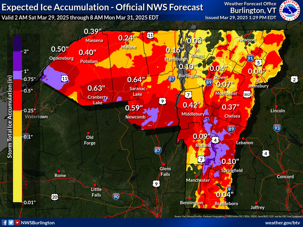
Ice accumulation forecast map from the National Weather
Service in South Burlington. This combines what's already'
happened plus what's going. Areas in dark red, and
especially lavender risk extensive tree and power line
damage between now and Sunday. 
The headline this Saturday evening is that I'm definitely worried about the additional freezing rain coming up tonight and early tomorrow for parts of central and southern Vermont. 

An ice storm warning is now up for most of central and southern Vermont through 8 p.m. Sunday. Expect very difficult travel - and much worse - likely pretty extensive tree and power line damage in some spots. 

There's much more to talk about regarding the ice, but let's set the table with how today went. 

Northern areas got the expected break. Once we got past 9 a.m. it was just light snow and flurries with no additional accumulation.  

The big winner in the accumulation sweepstakes was Fletcher, with 10 inches. Johnson and South Hero had 8.8 inches. Burlington managed to tie today's daily record with 1954 for most snow on March 29 with 7.0 inches. 

People near the Canadian border could actually see brighter skies just to the north late this afternoon.  That does not mean the storm is over by any stretch of the imagination, but it's a break.

Road conditions across the north that were atrocious this morning and pretty good late this afternoon.  They'll get worse again later, but we'll get to that. 

OMINOUS ICE STORM

In parts of central and southern Vermont a few places already have a quarter to nearly a half inch of ice clinging to trees and power lines.

Power outages haven't been too bad - yet.  All day, they've varied from near 100 homes and businesses without power to roughly 1,000.

I do think things will get much worse overnight.  

As of 5:30 p.m. some renewed rain and areas of freezing rain were beginning to move back into far southern Vermont. That will spread northward overnight. 

It's a complex temperature profile, so some places in the ice storm warning zone will only get a little freezing rain. Other spots will get a ton.  And it will be incredibly variable.  One area might be relatively OK, while a spot a couple miles up the road and a couple hundred feet higher or lower in elevation are absolutely slammed.

This is actually very typical of ice storms in mountainous places in Vermont. We saw this kind of thing in the Great Ice Storm of 1998. I remember in that storm driving  up the hill on Interstate 89 between Richmond and Williston. 

Halfway up the hill, it went from no ice on trees, to trees collapsing in a sharp line. Hardly no transition zone. 

Our current ice storm won't be nearly as bad as 1998, but definitely bad enough. 

ICE ACCUMULATION

Ice visible clinging to trees this afternoon in this traffic
cam grab from Hartford, Vermont. Much more ice is possible
tonight and that could cause some serious power
outages and tree damage.
In general, though, expected ice accumulations have gone up dramatically. The biggest worry zone is along and east of the Green Mountains in Rutland and Windsor counties. 

And extending south a little into corners of Windham and Bennington counties and north into some pockets of Addison and Orange counties. 

Between the ice on the trees now and what will hit tonight, everything in some spots by Sunday morning will probably be weighed down by a half inch to as much as an inch of ice in the worst hit areas.

I feel sorry for anybody who has a sugarbush or prized trees in the worst hit areas. If the forecast comes true, the damage will be extensive. 

The power outages might  be hard to fix, too, since there will probably be so much damage. Charge your devices now, those of you living in the ice storm warning zone. 

The precipitation will hit northern Vermont again, too, later tonight and Sunday. It'll likely start off as snow and then go over the freezing rain. There won't be much additional snow, maybe an inch or so. 

Places along and east of the Green Mountains in the northern half of the state will see up to a quarter inch of ice, which would cause some scattered power outages, but nothing like we expect further south.

The Champlain Valley will see a glaze of ice by early Sunday, too, but I don't think it will be enough to cause problems, other than dangerous road conditions. 

As chilly temperatures slowly relax Sunday, any freezing rain will change to a cold rain. But in areas protected from any warming winds will hang on to more icing well into the afternoon. Luckily rainfall rates will decrease noticeably in the afternoon.

MONDAY

This still isn't the biggest deal of this storm, but we're still expecting a brief squirt of very warm, humid for the season air on Monday. Most of us will reach the 50s and 60s. Showers will continue, and as a cold front approaches in the afternoon, heavy showers and even a few thunderstorms look like they'll develop. 

Flooding from melting snow and ice and the warm temperatures and the rain still looks like it will be minor, but we'll have to keep watching this. If rain ends up being heavier than expected, the flood situation could worsen.

I'm not too worried about that now, but it is worth monitoring. 


Friday, April 5, 2024

Vermont Storm Pretty Much Over, But I'm Still Impressed For Several Reasons

National Weather Service map of total snowfall from
our big storm for around the region. I'm really impressed
by the areas that had at least a foot of now (dark 
orange in red) especially for an April storm. 
 As expected, today turned out to be a cloudy, raw day as morning wet snow showers changed over to cold light rain showers and sprinkles.  

At least in the valleys. 

Above 2000 feet in elevation, a little snow continued, but it wasn't amounting to a huge amount.

Final snowfall totals are in. I'm impressed by how many Vermont towns reported at least 20 inches. 

Even more impressive is it wasn't limited to just one section of the state.  That's pretty unusual (but definitely not unheard of) for any snowstorm including those that strike in midwinter. 

There were reports of that much snow in Rutland and Windsor counties, and also in the Northeast Kingdom and points in between.  Also impressive was how widespread an area at least a foot of snow fell, This includes many low elevations. Again, very unusual for an April storm, when big totals are usually limited to higher spots. 

So yes, this was a historic storm for April. 

IMPROVEMENTS

Another impressive feat is the pace at which repair crew are restoring power. At dawn, nearly 18,000 Vermont homes and businesses were without power. That number was down to about 5,200 by 4 p.m. 

Since no new snow accumulations worth mentioning are in the forecast for low elevations and very little new snow in the offing up high, the downward trend in outages will definitely continue. 

I noticed quite a bit of tree damage around St. Albans today from the heavy wet, snow.  It's not nearly as  bad as the destruction from the huge windstorm in January. But I did see snapped branches and trees.  At least two trees are damaged on my property, but most are unscathed. 

The big melt began today, despite temperatures holding
in the upper 30s. Here's my yard in St. Albans, 
Vermont at around 7:30 this morning.....


It does look like a lot of people will be doing yard clean up because of this storm once the snow melts. 

Despite today's chill - highs only made it into the mid and upper 30s - the snow melt was, well, impressively noticeable. There's that word again.  

The snow would have never melted nearly this fast back in January if we'd had the same amount of snow with the same temperatures.

It will take awhile to get rid of the deepest snow. But with warm ground and a high sun angle sending a bit of heat through the clouds, we'll lose the snow pretty quickly. It'll take a few to several days, but our regularly scheduled spring is close at hand. 

Tonight, the light rain showers will eventually change to wet snow showers in many valleys. Temperatures there will bottom out not far from 32 degreesand continue in the mountains.  With temperatures tonight near the freezing mark, not much snow.

The weather will continue to improve and warm up, but only very grudgingly at first. We'll still have a lot of clouds and light showers around Saturday. Highs will be a few degrees warmer than today, reaching the low 40s in many valleys. 

That's still chilly for April, but the melting process will accelerate just a bit. 

The sun will break out on Sunday, especially in the afternoon and evening as it gets even warmer - 45-52. That's a couple degrees on the chilly side for this time of year, but not bad.

I'll have more on Monday eclipse day weather in the coming days. But so far - knock on wood - so good. It still looks like there might be some high clouds around, but they should be thin enough to still view the spectacle.

......and the same view at 5:30 p.m. just 10 hours later.
MORE AFTER EFFECTS

The hordes of tourists to the Vermont eclipse zone will encounter plenty of slush, mud and melt water while they're here. They won't care, because as noted it's looking like the skies will be at least partly clear..

I just wonder how many GPS setups will put unsuspecting or clueless people on dirt roads. They're sodden and muddy now. With all this snow melting, it will only get worse. 

 I imagine a few people might experience the eclipse with their vehicles sunk into the mud.  

Word to the wise: Plan ahead when scoping out your eclipse viewing spots.  And seek out places to watch where you stay on paved roads to get to your destination.

No hiking, either: Hiking trails are super sensitive this time of year with the melting and the mud. You can really ruin some ecosystems tromping along hiking trails. 

Another risk from all this snow it the risk of eventual flooding. There's one to 2.5 inches of water in that new snow pack that appeared yesterday.  The melt will go on gradually enough at first, with no problems through Wednesday. 

The wild card is the end of the week. There's some sort of storm possibly brewing, and it could be a rather warm storm.

Current forecasts have temperatures in the low 60s and rain by Friday. 

That would really accelerate the snow melt and feed water into streams and rivers that will already be running kind of high. If rainfall with that storm is modest, then we're fine. If it's very heavy and comes in a short burst, we could be looking at flooding. 

It's way too early to tell how that storm will shape up.  At least it looks like it won't be another snowstorm.  

Saturday, January 13, 2024

Early Saturday Afternoon Update: Power Outages Rampant In Vermont With Today's Windstorm, New Areas Hit

A fallen tree blocks Cochran Road in Jonesville/Richmond
this morning. Jonesville and Bolton were apparently
among the hardest hit areas of Vermont with this
windstorm. Gust have since diminished. 
 As expected, this morning's windstorm caused a new round of big havoc across much of Vermont, downing tons of trees and powerlines. 

Power outages peaked at just under 29,000, which is impressive for sure and more than the number who lost electricity in Wednesday's storm.

The storm slammed some areas that were not so badly hit. Orange County, was hit hard, as were Addison, Chittenden and Rutland counties.

A whopping wind gust of 86 mph was reported by the WPTZ mobile weather unit near Middlebury.

In Rutland County, damaging winds extended well west of the Green Mountains, something that was hinted at in prior forecasts.

My sister Lynn reported strong winds and tree damage near her West Rutland home. Trees and wires were down even further west in Castleton. 

The area around Jonesville, Bolton and Jericho were hard hit by downslope winds. I was in Jonesville this morning and saw numerous trees down.  This was also an example of how localized these downslope winds can be.

Just three miles to the west of Jonesville in Richmond Village, winds were much lighter and I saw no damage there. 

High wind warnings should expire early this afternoon as winds have diminished. It looks like repair crews are taking advantage of the lighter winds, as the number out outages had declined to about 23,600 as of 12:30 p.m., says VTOutages.org 

Rain was falling across most of Vermont this afternoon, so it's not the most pleasant storm clean up in the world. Temperatures will slowly fall for the rest of the afternoon, so I think we'll see more and more instances of snow mixing in.

However, the precipitation will also be getting more showery, so any snow that does accumulate toward evening will be no big deal. And mostly limited to the mountains. 

By the way, snowfall during the storm last night was pretty unimpressive. I've seen a few reports of three or four inches in some mid and higher elevations, but that's about it.  

Sunday is going to be a gusty, cold, cloudy day with snow showers around, especially north. So it will be another unpleasant day for cleanup, I'm afraid.

I'll have storm updates if warranted later today. Stay safe out there, folks!  


Wednesday, April 27, 2022

Snow Makes A Return Visit To A Vermont Spring

Large fallen branches still litter a South Burlington lawn 
on Tuesday, a week after a wet spring snowstorm damaged
trees in much of Vermont. Tree trimming companies
are swamped with requests for help from storm damage
A little over a week after a wet snowstorm trashed lots of trees and power lines across much of Vermont, the Green Mountain State is facing more snow today through tomorrow. 

This time, thankfully, there will be much less snow for most places than what we had on April 19. Some places won't get any at all. 

But, we certainly have another interruption of spring to talk about, as cold north winds, clouds and low temperatures won't put you in the mood to dance with the daffodils for the next few days. The snow will mostly be in higher elevations, and the Northeast Kingdom.

The culprit is a storm in both the lower and upper levels of the atmosphere blossoming near Maine and New Brunswick. It's pulling cold, wet air around the back side of it. Atmospheric steering currents over the Atlantic are all gummed up at the moment, so that storm will sit and spin now to Saturday, keeping us chilly, mostly cloudy, and at times, snowy. 

Most of the snow we do receive comes this afternoon and tonight. Snowflakes will eventually make it down to many valley floors overnight, but if anything accumulates in the lowlands, it will just be a slushy coating on the grass.

At and above about 1,500 feet above sea level in northern Vermont, there's a good chance of seeing one to three inches of snow. Some of the highest elevations and a few spots in the Northeast Kingdom could see four or five inches, says the the National Weather Service in South Burlington. 

There might even be enough snow for an isolated power outage or two, but we won't see anything like the scale of last week. 

The Northeast Kingdom missed out on a lot of last week's snow, so I guess it's their turn. 

For all of us though, we'll endure some March like weather, especially today through Friday. That means highs only in the 40s, with a few upper 30s in the coldest places in the Northeast Kingdom. Overnight lows for the next few nights will be near or below freezing.

Since the storm will be stalled near New Brunswick, the further east you go now through Saturday the worse the weather will be.  Northern New York might actually be fairly sunny starting tomorrow.  Vermont's Champlain Valley will see some peeks of sun occasionally, but the Northeast Kingdom looks gloomy.

Things will start to improve Saturday  and especially Sunday, when that pesky storm finally gets a good shove out into the Atlantic Ocean. By Sunday afternoon, temperatures should be in the 50s to around 60, which isn't far from normal for this time of year.

Beyond that, the weather looks like it will be a typical spring pattern of changeable weather, with nothing too extreme in the offing.

Meanwhile, the fallout from last week's storm continues in Vermont. Tree companies are slammed with business with wait times to remove fallen and damaged trees extending into weeks.  One victim of fallen trees said the chain saw guys couldn't even look at their damage the day and day after the storm because there were prioritizing all the houses and cars damaged by the trees.

The McNeil Waste Wood yard in Burlington, where people can bring their clean wood, such as branches and broken trees, had an immense pile of storm damage as of Wednesday. The attendant there said it's been incredibly busy since the storm.