Saturday, August 19, 2023

Rare Rhode Island/Massachusetts Tornadoes Friday Morning

Screenshot from a Tesla video on I-295 in
Rhode Island shows the tornado crossing the highway. 
 While I was a post for this blog thingy early Friday morning and noticed quite a thunderstorm complex coming into Connecticut.  

At the time the forecast included a very low but not zero chance of tornadoes in New England, all the way into Vermont.  I wrote that I thought the Green Mountain State was pretty safe from a twister, but I wondered about far southern New England.

Well, I was right to wonder, as it turns out.  

A pretty concentrated area of tornadoes hit Rhode Island and southeastern Massachusetts a bit later Friday morning, causing quite a lot of damage, but no super serious injuries.

The most impressive tornado took an off and on path through Scituate, Johnston, and North Providence, Rhode Island. It was an EF-2 with top winds of 115 mph.  It was the strongest Rhode Island tornado since August of 1986,

Dramatically, the tornado crossed I-295 in Rhode Island, lifted a car several feet in the air, turned it around and then slammed it back down on the highway. The woman driving the car was taken to a hospital but her injuries were reported to be relatively minor. 

One house directly struck by the tornado lost most of its roof shingles, had windows blown in and the front door was dislodged from its frame. Hundreds of trees were uprooted or snapped off.

There were at least three other tornadoes in that general area, according to the National Weather Service office in the Boston area.

 An EF-1 with 80 to 90 mph winds caused damage in North Attleborough and Mansfield, Massachusetts. Another, higher end EF-1 with winds of up to 110 mph caused roof and tree damage in Weymouth, Massachusetts. A weaker, brief tornado, an EF-0 with winds of up to 90 mph, caused a little more damage in Stoughton, Massachusetts.

Meteorologists will be investigating other damage in Scotland, Connecticut to determine whether yet another tornado touched down there. 

So, four, possibly five tornadoes in southern New England. Like I said the other day, it's almost as if we have another tornado alley in that region.  

Here in Vermont, the weather Friday stayed well-behaved.  I saw no reports of any severe weather.  Although one or two instances of flash flooding had been considered possible, I have no reports of any high water or washouts. 

Today might not be the nicest Saturday ever, with clouds and plenty of light showers around, especially north. It'll be a cool one, too, as temperatures will barely make it to the low 70s in the warmer spots and many places will stay in the 60s. 

Autumn is coming!

Friday, August 18, 2023

Latest Canadian Wildfire Nightmare: Yellowknife NWT Evacuated, British Columbian City Endangered

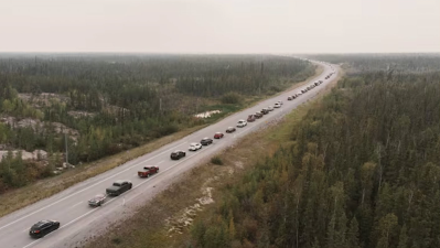
A long line of vehicles on Highway 3 leading out of 
Yellowknife, Northwest Territories, Canada. The 
entire city of 20,000 was evacuated due to an
advancing wildfire. Photo by Pat Kane/Reuters.
 Canada's year of wildfire devastation just keeps going on, as major new fire crises are hitting the nation's northwest corner and also its westernmost province.  

The last of the 20,000 or so residents of Yellowknife, Northwest Territories were on their way out of town Friday as a huge wildfire bore down on that city. 

Yellowknife is known for its frigid winter climate, but the story now, like most of Canada has experienced at one time or another this year is fire.

As the massive fire bore down on Yellowknife, and local authorities this week decided the best course of action was to get everyone out by Saturday, when the wildfire is expected to arrive. 

As you can imagine, abruptly evacuating a city of 20,000 is pretty chaotic.  Plus, it's a major hub for all the little villages up in that corner of Canada.  It looks surprisingly large for the population in photos, complete with a busy downtown and high rises. A huge region does its commerce in Yellowknife. So the evacuation is incredibly disruptive  to say the least, even if ultimately, no homes there are destroyed by the fire. 

A majority of Yellowknife residents have been able to drive out of the city despite the nearby fires and areas of dense smoke. The traffic was stop and go, however, as motorist made their way through smoke, and carefully had to pick their way through areas already burned over. 

People without easy access to cars, and the elderly or those with health problems and some families were scrambling to get flights out of Yellowknife.

Flights out of Yellowknife got bogged down by smoke and other weather conditions and not everybody who wanted to leave on planes Thursday could.  So people who waited for hours at the airport were told to go home and come back Friday morning. About 21 flights with room for about 2,000 people were scheduled to depart Yellowknife on Friday. 

Weather conditions are ominous for Yellowknife. A passing storm system might produce a couple of scattered rain showers today and tonight, but those won't be nearly heavy enough to disrupt the fires.

Strong winds behind the storm gusting to 30 mph from the northwest and west, would drive the fire toward Yellowknife. 

Officials were trying to save the city by bulldozing fire breaks around neighborhoods and turning on as many sprinklers as they could.

The whole situation is reminding people of the massive fire that destroyed large sections of Fort McMurray, in northern Alberta back in 2016.

To add to the chaos, after you evacuate people, where do you put them? The larger cities of Edmonton and Calgary, Alberta are doing their best to accommodate as many fire refugees as they can. 

They might have to find room for more. 

Another large fire is threatening a much larger city than Yellowknife. Kelowna, British Columbia with a population of over 130,000 is also under siege from an immense wildfire. So far, there's no need to evacuate that entire city, but at least 2,400 people have been evacuated.  Already an unknown number of homes have been destroyed. 

A wildfire looms above houses near Kelowna, British
Columbia this week. Phot by Ben Nelms/CBC.

Evacuations were also underway around Lytton, British Columbia. If the name of that tiny town rings a bell, it's because in June, 2021, the community record Canada's hottest ever temperature - 121 degrees. The next day, a wildfire destroyed most of Lytton. 

Fires have been burning much of the summer in British Columbia. The blazes got more intense this week as record heat enveloped much of the province. 

This has easily been the worst year on record for Canadian wildfires. As the Washington Post reports:  

"More than 1,000 active fires were raging across Canada on Friday as a combination of record-challenging heat, climate change and long term drought has exacerbated the wildfire season. This year's fires have burned twice as much land in the country as any previous season - an area equivalent to Alabama."

I can't get through this post without mentioning climate change.  Sure, summers are variable and entire huge nations like Canada can have dry and warm years as well as chilly, wet ones. 

But the dry, warm year of 2023 has been made worse by climate change. What might have been routine warm spells and scattered wildfires decades ago have evolved now into record heat and huge conflagrations. 

At this point, the only thing that will firmly put an end to Canada's wildfire hell is winter. 


One More Round Of Storm/Flood Threats In Vermont Before "Fair Weather" Takes Hold

As we approach the end of summer, forests begin to 
look tired. And you see splashes of fall color
from trees that aren't particularly healthy. 
 We've entered into what I call the tired phase of a Vermont summer. 

It still gets humid, but most of the time, anyway, we stop seeing the kind of heat waves we get earlier in the summer. Those towering clouds that produce thunderstorms often don't seem as enthusiastic as the big billowing updrafts of July and August. 

Forests and gardens look like they've had enough too.  A few sugar maples that aren't in good shape are already starting to show fall colors. The green on some of the hillsides looks a little faded. Look closely, and some of the leaves look a little crinkled and gray around the edges.

Chances are, your garden looks weary, too. Those perky ever so neat rows of new plants in May and June are now look like an unmade bed after a night of, ahem, activity. You've already scoured through them harvesting, and you probably have partly given up on weeding. It shows. It's near the end of summer after all.

Perennial beds are a mess, too. They're still pretty, but they also feature spent day lilies, gnarly hollyhocks, the fades mess of long-wilted spring flowers and those weeds. 

Of course, Vermont's summer of 2023 is kind of one to forget. We know all about the repeated storm and flood threats, a few of which didn't cause problems, but most did. 

True to form as this tired summer drags on, we have another threat today. Not a big one by this year's standards, but one to watch anyway. Then we get into the next phase of our waning summer, "fair weather." More on that in a bit. 

TODAY

Part of the problem is that the ground remains amazingly wet. For the most part, the last wet day we had, Wednesday, shouldn't have been that big a deal.   Generally a half inch to an inch fell, with some spot amounts at or a little above 1.5 inches. 

That normally would not cause much of a reaction at all. But its so wet that even that paltry amount, spread over an entire day, got brooks and streams running fast. Eventually, even the main stem rivers were running high. Not flooding, but high. I noticed surf was really up on the Winooski River Thursday morning. 

Some light showers Thursday evening ahead of
this morning's drenchers triggered this rainbow
over St. Albans, Vermont. 

 A band of rain, some of it heavy, was plodding eastward through Vermont this morning. 

Since it's been so wet, there could be just enough of a downpour in one or two spots to create some local flash flooding issues. If that happens, it won't be widespread at all, and won't last long. Still, it's best to keep an eye out. 

Even though this morning's storms mostly aren't severe, there's enough spin in the atmosphere that there's still a very low, but not zero chance that some storms could spin up a brief tornado, generally south of Route 2.

However, as I looked at radar images the morning, the strongest storms were down in Connecticut, heading toward Rhode Island and southeastern Massachusetts. I think there's a bit of a better risk of high winds or a quick spin up down that way. 

More scattered showers and storms will fire up this afternoon. We'll also have to watch those in case there's one or two instances of damaging winds or high water. However, the risk of all that is low.  Be weather aware, but this falls well short of panic mode. 

WEEKEND

Saturday will be the first in what will amount to several fall preview days. The storm system causing today's weather will be to our north. We'll have cool northwest breezes, plenty of clouds, especially over the mountains, and scattered light showers.

Those showers should be most persistent in the mountains and close to the Canadian border. They might last into the night. 

Sunday still looks nice, with clearing skies leading to at least a partly sunny comfortably warm afternoon. 

"FAIR WEATHER"

The weather pattern across the United States is amplified. That means that, at least for this time of year, there's lots of big dips and bulges in the path of the jet stream overhead.

A big dip in the jet stream is steering Hurricane Hilary toward California, as I mentioned Thursday. 

Meanwhile, there's a big northward bulge over the middle of the nation That's  heat ridge, and I expect a fair number of record highs over the next week or so over much of the Plains and Midwest.

On the front side of that ridge, the air will be blasting southeastward toward another dip in the jet stream off the New England coast.

 This will create very traditional "fair weather" in Vermont.  That's the kind of hybrid summer/autumn weather you often get in the Green Mountain State in the final days of August in early September. It's the time of year when county and state fairs are making the rounds. 

Afternoons are warm enough, usually in the 70s, so it still feels like summer as you stroll down the fair Midway.  But as the sun sets, you'll need a jacket or sweater to ward off the evening chill during the Grandstand Show. 

As the climate has changed, "fair weather" in Vermont has seemed to shift into mid-September, when most of the fairs are actually over. But this year appears to be a throwback into tradition.  So it's a little nostalgic really.  

And since "fair weather" features no extremes, that will be a nice break from the kind of summer we've had, too. 

Thursday, August 17, 2023

Southern California Has A Chance Of Getting First Tropical Storm Since 1939

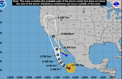
One forecast for the path of Hurricane Hilary. If it arrives as an 
intact tropical storm by the time it reaches California,
it'll be the first time since 1939 that's happened. 
It never rains in Southern California, goes that old song from way back in 1972.

The song is actually partly true. It almost never rains in southern California, at least in the summer. If it does rain during the summer, it's scattered and brief and doesn't amount to anything. 

Or not. 

The coming days could well be an exception to that no rain rule.  A tropical storm, or at the very least its remnants, appear poised to blast much of California, including, or even especially southern California in the coming days. 

The culprit is Hurricane Hilary, which was rapidly gaining steam today well off the central Mexican west coast. It has top winds of 105 mph and is expected to strengthen rapidly. 

Most hurricanes that form near the west coast of Mexico or Central America usually either hit the southern or central west coast of that nation and quickly die, or the bash into Baja California and wind down quickly there. Or even more often, they head northwest and fall apart in the chilly Pacific Ocean waters southwest of California.

A few of these Central American or Mexican-born storms launch long journeys westward into the central Pacific Ocean roughly toward Hawaii, as the recent "Dora the Explorer" hurricane did this month. 

This isn't the case with Hilary. Steering currents are bringing it northward toward the long Baja California peninsula. If Hurricane Hilary makes landfall into Baja California, it'll fall apart, but still give the southwestern United States heavy rain and flooding over the weekend or early next week.

If Hilary stays just off the west coast of Baja, that's a different story.  The water is cold off of Baja and southern California. Hurricanes hate cold water, so they weaken when they encounter such conditions. 

However, Hilary will be a strong hurricane on approach.  So it'll take awhile for it to weaken as it comes toward California. Plus the cold water off the coast isn't nearly as chilly as it usually is. That's  thanks in large part to the current El Nino, with an assist from climate change. So that would slow the weakening process too. 

If Hilary is still an intact tropical storm by the time it lands in California - an iffy but still real possibility, it'll be the first time since 1939 that a tropical storm has hit California. (There have been other instances in which former hurricanes and tropical storms have unleashed flooding and locally damaging winds hit California, but this is after they transitioned to non-tropical storms).

The September, 1939 tropical storm dumped 5.62 inches of rain on Los Angeles and more than 11 inches on Mount Wilson, California.  Winds gusted to 65 mph in parts of southern California.  

Storm surges devastated Long Beach and other coastal communities.  A total of 45 people died in that storm. 

A hurricane or strong tropical storm is also believed to have struck southern California in 1858.

The 1939 hurricane hit under similar conditions to today. A strong El Nino was in progress. An intense heat wave scorched southern California in the days leading up to that storm. A strong heat wave is now hitting parts of that region.

Whether or not Hilary maintains itself as a tropical storm by the time it reaches California, heavy rain and flash flooding now seem almost inevitable.  At least scattered areas of flash flooding, but probably more, are in the forecast for much of California starting Saturday and continuing through Sunday and into early next week. 

Remember that song I mentioned at the top, how it never rains in Southern California?  I think a lyric from that song is about to come true: "But girl, don't they warn ya: It pours, man it pours."

Wednesday, August 16, 2023

As If Deadly Wildfire Not Enough; Maui Faces Land Grabbers, Conspiracy Theorists

Aerial view of a neighborhood destroyed by the
deadly wildfire in Lahaina, Maui, Hawaii. Land 
speculators are already contacting victims in
attempts to buy land at cut rate prices 
as an "investment opportunity."
While good people reach out to help the people of Maui begin to recover from the wildfire that killed at least 106 victims, there's always a few bad apples who try, through personal greed or delusions, to make matters worse.   

On top of everything else, Maui is facing people trying to make a quick buck, some by running real estate scams, others by seeking clicks on social media through dubious conspiracy theories.

REAL ESTATE "OPPORTUNITY"

When most people look at the Maui calamity, they see a tragic disaster.  A few soul-less people apparently see it as an exciting investment opportunity. 

As ABC News reports:

"Local officials say outsiders are attempting to take advantage of the tragedy by attempting to purchase damaged home sites from locals who have lost everything. 

Officials expressed concern that residents are being approached about selling residential sites 'by people posing as real estate agents who may have ill intent.'"

Hawaii has the highest housing costs in America, which makes it incredibly difficult for middle income people to buy homes in the best of times. Now, the housing crisis on Maui has gotten exponentially worse. 

Which means if a real estate investor can get their hands on any land in Hawaii, they'll make a killing. 

Even so-called "legitimate" real estate moguls are literally swooping down on the wreckage in Maui like vultures, trying to make a quick buck.

According to the Independent:

"While thousands of people living on the islands are trying to recover and find shelter, investors see an opportunity. In a video posted to Instagrams member of the nonprofit organization Kako'o Haleakala claimed land investors were already calling Lahaina residents who lost their homes, offering to buy their land." 

The Independent noted in was unclear which investors or realtors the Instagram post referred to. 

USA Today has reported on the same issue.  They report:

"Mark Stefl, 67, said he, too, has been approached by developers, and the offer felt like being kicked while he was down."   

This isn't a new phenomenon. After Hurricane Katrina in 2005, real estate "investors" swooped into New Orleans to snap up damaged property at bargain basement prices, The same thing happened after western wildfires.

While it is certainly perfectly legal for property owners to sell their land as they choose, these real estate vultures seek to catch people when they are vulnerable in the immediate aftermath of a disaster. This would be at a time that these property owners would understandably find it difficult to make rational decisions.

The real estate vultures know this, and would end up "negotiating" a purchase that leaves the seller with much less money than if they sold under normal circumstances. To be blunt, it's a total ripoff. 

Against this backdrop, Hawaii Gov. Josh Green said he's is consulting with the state's attorney general to see if they can place a moratorium on any sale of properties that were damaged or destroyed.

CONSPIRACY WHACKOS

Every time a wildfire or something like this happens, the idiots come out of the woodwork to explain this is all a government plot to do...... I'm not sure. 

In the Maui case, people are posting old photos of events that sort of, kinda look like laser beams setting off explosive fires. 

Contrary to what conspiracy theorists would
have you believe, this is not a energy
weapon starting Maui on fire. It's a refinery
flare creating a light pillar in frigid 
winter air back in 2018.

The most popular conspiracy theory is related to the real estate stuff I cited above.  The whack jobs say the real estate moguls and the "elite" in cooperation with the government, set these fires to allow the rich to conduct a land grab.

As you can see by what I wrote above, it doesn't look like real estate "investors" need expensive government equipment to try and make land grabs. All they  have to do is call or email victims in their attempts. 

The Associated Press offers us some examples of how people use real photos from unrelated events to "prove" their conspiracy.

One photo shows a distant fire with a beam reaching into the sky over it. The wackos say that's another example of the government for some reason launching fiery attacks using weaponized weather modification tactics on Maui. 

The photo is real, the context is not.  The photo actually shows a controlled burn at an Ohio refinery back in 2018. The beam of light is caused by ice crystals in the air creating the beam above the fire, which occurred in the middle of winter. 

Another image supposedly showing another example of the "government weapon" in Hawaii is just a photo of a Chilean electrical transformer exploding during high winds several years ago.  Yet another photo is just an image taken from SpaceX's Instagram account of a 2018 launch of a SpaceX Falcon 9 rocket in California, notes the Associated Press.  

Of course, my words here will do absolutely zero to discourage the conspiracy theories. I only write about it to say buyer beware. And OK, to mock the conspiracists a little bit.  

Dora The Explorer: Recent Hurricane Had Incredible Journey

A recent hurricane was dubbed
"Dora The Explorer" for its
long trek through two
oceans. 
Hurricane Dora popped up in the news in a tragic way.

It, and a high pressure system far to its north, helped created the strong winds on Maui that led to those those horrible wildfires. The death toll is now a horrible 106 people, and could easily rise further. 

Far less importantly, but pretty interesting nonetheless is the incredibly long journey Dora and its earlier ingredients as a tropical disturbance took.  The storm had such a long journey that it was inevitable dubbed Dora the Explorer.   

Hurricane experts first noticed what would become Dora on July 17, just off the west coast of Africa.  It moved westward across the Atlantic, briefly almost becoming a tropical storm or at least tropical depression on July 22 before reaching the Central American coast around July 28.  

Upper level winds over the Atlantic Ocean prevented wannabe Dora from becoming a tropical storm. And, being over the Atlantic, had it become a tropical storm, it would have been named Emily.

Anyway, wannabe Dora crossed over the mountains of Central America and landed over the Pacific Ocean on July 29.  Conditions were far more conducive for development over the Pacific, so by August 1, Dora became a hurricane and began its long trek westward across the Pacific Ocean. 

Dora was a beast over the open Pacific Ocean, lasting at least four days as a Category 4 hurricane with winds up to 150 mph near its eye. 

Last Friday, Dora became only the second hurricane on record to survive a trip across the eastern, central and now western Pacific basin, as the Washington Post noted. 

The only other hurricane known to accomplish this feat was Hurricane John in 1994.  Most hurricanes sputter out in the central Pacific Ocean because the water is cooler there, the air is often drier, and wind shear that's common in that area usually tears hurricanes apart. 

One possible reason why Dora was so persistent was its construction.  Most hurricanes look like spirals.  Dora was known as an annular hurricane. That means on satellite photos it looked more like a doughnut than a spiral.

Annular hurricanes like Dora can fend off dry air intrusions and upper level winds that would otherwise rip a hurricane apart. 

On Friday, Dora crossed the International Date Line at 180 degrees longitude. That put it in the western Pacific basin. Since it was now on the Asian side of the Pacific, it forced a rename: It was now Typhoon Dora, not Hurricane Dora. 

Last we checked, Typhoon Dora was finally weakening into a tropical storm somewhere in the western Pacific Ocean. 

Tuesday, August 15, 2023

Remarkably (After This Summer's Disasters) Vermont Once Again In Bullet Dodging Mode

Finally, a Vermont weather trend with no flooding, no
major storm damage, just things like this nice
sunset over St. Albans, Vermont Monday 
A quick update for Vermont today, because there's an odd reason to celebrate. 

Yes, I know it's rainy and dreary in parts of the state this morning. Yes, I know it's been raining all summer.  

For a change, though, we seem to have fallen into a dodge the bullet mode.  For instance, a severe storm outbreak in the Northeast Saturday mostly missed us, with just a handful of reports of storm damage in Vermont. 

Today is another close miss. The storm bringing the rain to southern Vermont created flash flood problems through the Middle Atlantic States Monday.

 By far the most distressing part of all this was a flash flood in Washington DC that collapsed a wall at a dog daycare center. Several dogs perished, which makes me feel horrible. 

Up here in Vermont, today's rainfall in southern Vermont won't be nearly enough to cause flooding. Northern Vermont is getting little or no rain. Sunshine might even break out in that part of the state this afternoon. 

The next storm, on Thursday at this point also looks to be a non-starter. There is a chance it could produce enough rain to create some local problems here and there, but that's really uncertain at this point. We're following trends on that one in case we get surprised again. 

We're also missing out on heat waves. The South has been baking for weeks, the Pacific Northwest is having a record heat wave currently. Dangerous, possibly record breaking heat is forecast for a large swath of the Midwest this weekend and early next week.

Meanwhile, here in Vermont, the hottest it's gotten all month so far in Burlington is a mild 83 degrees.  No hot spells are in the forecast for at least the next week. We've dodged the heat bullet, too!