
 |
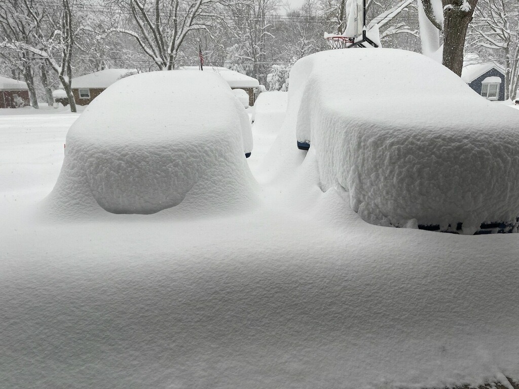
| Larry Dubill, @LarryDubill on Twitter, photographed these cars in Hamburg, NY, and this is before the snow really got super deep. |
The world's biggest fan of thundersnow, Jim Cantore, the intrepid long time reporter for The Weather Channel, has parked himself in Hamburg, New York to report on the storm. Video shows him gleefully wading into waist deep snow.
Overnight and early this morning, there were lightning strikes around Hamburg, too, so I'm sure he was elated.
The fact there was is lightning is a sure sign that these lake effect snow bands are super intense.
So far, the heaviest snow has been mostly just south of Buffalo. The intense snow band has shifted north from time to time into the heart of the city
As of this morning, the total snowfall in Buffalo, at least officially measured at the airport, is a somewhat manageable 12.5 inches. But the band of intense snow is starting to creep north again, and should engulf Buffalo for much of the rest of the day.
The sweet spot is probably where Cantore is, just south of Buffalo where the several feet of snow forecast is still in play.
I'm having trouble keeping up with the snow total for places like Hamburg. It changes every minute. As of 10 a.m. Hamburg had received 33.9 inches of snow. Twenty-one of those inches came in just six hours.
Needless to say, the New York State Thruway is closed south of Buffalo.
Oh, and by the way, they had the wisdom to move Sunday's Buffalo Bills vs Cleveland Browns game out of Buffalo and moved it to Detroit. Smart move.
These snow bands are pretty narrow, too. Drive several miles north or south of Hamburg (good luck with that!) and you basically get a routine light snowfall.
 |
| Satellite photo shows intense lake effect snowband coming ashore on Lake Erie south of Buffalo this morning, and another intense one off of Lake Ontario punching into northern New York. Click on the image to make it bigger and easier to see. |
A similar snow band is coming off of Lake Ontario with feet of snow accumulating near Watertown, New York as expected.
The lake effect snow machine is so strong that some of it is making all the way to Vermont. One piece of a streamer from Lake Ontario broke off and dumped a quick inch of snow on northern parts of the Green Mountain State early this morning.
Another push of this snow band was dumping a few inches of snow on the central Adirondacks at mid morning. It also caused light snow to break out again in norther Vermont. Visibility was very briefly down to maybe a mile in St. Albans, Vermont at 10:15 a.m., so these are more than just flurries.
Winds will bend a little more southwesterly today, taking the snow more into Buffalo, as noted, and near or even north of Watertown, New York. That would temporarily mostly nend the lake effect light flurries in Vermont
This is the midway point of this storm. I will not at all be surprised to see these forecasted six foot snow totals in a few spots.
No comments:
Post a Comment