The sun and warmth are about to ramp up into record territory here in Vermont in the coming days.
The next few days will feature highs in the 60s to near 70, with the warmest day on Saturday. The high temperatures on Saturday actually have a shot at tying or breaking the all time record for hottest November day.
Typically in a Vermont November, it's cloudy, chilly and damp, with cold breezes, and even colder rain or snow showers. Highs this time of year should be within a couple degrees either side of 50.
This is far from typical November weather.
There's already been record warmth in the Midwest, and that air is headed our way. In North Dakota, often a frigid place by November, it was 77 degrees in Bismarck yesterday. Minneapolis reached 76 degrees on Wednesday, besting the previous record high of 72. Mobridge, South Dakota hit 80 degrees, making it the hottest November day on record there.
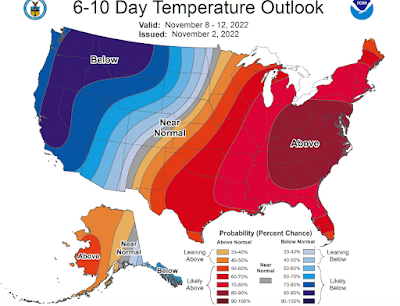
The pattern that's setting up is bringing winter to the western United States and summer to the East. At least for a few days. In between, severe weather and tornadoes, more typical of spring that autumn, are forecast to rake parts of Texas and Oklahoma today.
Between now and Sunday, the epicenter of the warmth, relative to average anyway, is setting up in New England. That's why the record high temperatures are in the forecast.
The all-time highest temperature for November in Burlington is 75 degrees, set in 1948 and 1950. The forecast high in Burlington Saturday is 73 degrees, which would break the record high for the date of 72 degrees.
I've noticed that since late October, many of these balmy, sunny days have been coming in a little warmer than forecast. Given that trend, it's possible we could break the month's record. One thing that could prevent that all time record is strengthening southwest winds on Saturday that could bring just a touch of cooler air off of Lake Champlain.
Saturday night, you'll want to leave some windows open and you might almost be tempted to reach for the air conditioner. Overnight "lows" in the Champlain Valley will be in the low 60s, which is normal for July. Other areas of Vermont will stay in the toasty 50s.
A weakening cold front will arrive Sunday with some showers, but it will stay mild through Monday. Another front will bring a brief shot of chilly air to us next Tuesday and Wednesday, and we might even see a day or two of very slightly below normal temperatures.
But it will stay sunny through that brief cool period, contributing to this very oddly bright November.
The weather pattern looks to say warm and dry overall into the middle of the month.
Before you get too smug, we all know this oddly warm, sunny November weather will eventually be taken away seemingly in an instant. There's several examples of November weather whiplash, in which record early November warmth is followed by record wintry cold.
For instance, on November 6, 1938, the temperature in Burlington reached 74 degrees, which at the time was the all time hottest November reading. By November 26 of that year, the temperature dropped to minus 3, which remains the coldest November reading on record in Burlington.
In 1996, it was 74 degrees on November 8, but down to 10 above just six days later. In 1989, it was 73 degrees on the 16th, the warmest for so late in the season. This was followed by a temperature of 6 above just a week later, and we ended up with the coldest December on record that year.
You get the idea.
We won't necessarily go from one extreme to the next in this go-around of early November warmth, but do enjoy it. You won't see weather like this again, probably at least until April.


No comments:
Post a Comment