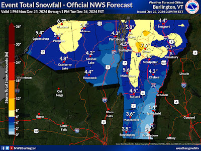
Our little pre-Christmas Vermont snowfall prediction keeps getting less and less little.
winter storm warning. Expected snow totals in the warning area have been bumped up a little to a predicted total of six to eight inches, with locally higher amounts.In the winter storm area, snow overnight could come down at a rate of an inch an hour at times, so it looks like a pretty good blast of snow.
The remaining winter weather advisories that had been in effect in Vermont from along and north of Route 2 and Route 302 are still on. But those advisories have been expanded southward.
Addison, Orange and Bennington counties are now in the winter weather advisory, as is the Green Mountain spine in central Vermont.
It's not just the winter storm warning zone where predicted totals are up. It's really everybody in and around Vermont. All areas of the Green Mountain State should receive - give or take - roughly an inch to an inch and a half more snow than we saw in the forecasts first thing this morning.
It looks like it'll get kind of windy overnight in the Champlain Valley, so things could get particularly tough overnight there, with blowing and drifting snow cutting visibility even more.
The National Weather Service in South Burlington says how much snow actually accumulates will depend somewhat on wind in the atmosphere. If the winds blow the falling snowflakes to smithereens, then accumulation won't be quite as deep, but a little denser than it otherwise would be. If the flakes stay nice and whole, accumulations might be slightly higher, but it would be a fluffier snow cover.
Given the snow on the ground and the stuff we're about to get, it's safe to say all of Vermont now has a 100 percent chance of a white Christmas
The timing of this has been pushed up a little, too. You probably ought to try to get all your driving around and errands done by around 6 p.m. this evening, as the snow should get into New York and western Vermont by 8 p.m. or earlier. Eastern Vermont will probably wait until after 8 p.m.. Southern Vermont, which will get less snow than the north, is probably safe from accumulations until after 10 p.m.
The heaviest snow looks like it will hit between roughly midnight tonight and 6 a.m. Tuesday The roads should be not great early in the day.
It still looks like the snow will be done by midmorning tomorrow. So if you're driving on Christmas Eve, it's probably best to wait until noon to take off. By then, most of the roads should be in good shape.
It'll stay pretty chilly for the next few days, but not as bad as it was this morning. Christmas through Friday, expect highs in the 20s and lows in the 5 to 12 above range, with the cold hollows being colder, and the upper elevations being warmer above an expected temperature inversion.


No comments:
Post a Comment