Showing posts with label Oklahoma. Show all posts

Saturday, March 14, 2026

Storm Chasers Injured In Crash; Other Chases More Dangerous Than Tornadoes.

An overturned KFOR storm chase vehicle last week
in Oklahoma after being hit by another storm
chaser that blew through a stop sign
You'd think the biggest danger to all those storm chasers hunting tornadoes in the spring and early summer are the twisters themselves. 

It turns out the greater danger is other chasers.

We're getting into storm chasing season, where hordes of people take to the open roads of the Plains, Midwest and South to study, photograph and video tornadoes for fun and profit.

And sometimes science, but mostly for fun and profit. The peak of tornado and twister chasing season is April, May and June. 

The fatigue of driving long distances to find tornadoes, and the act of staring at the storm instead of the road makes chasing tornadoes scarier than the actually twister.

We've already had an example of this. Last week when two storm chasers for KFOR, now as the 4Warn Storm Team were injured when an amateur storm chaser reported blew through a stop sign and hit the KFOR vehicle. 

The KFOR chasers, Connor Tune and Blaze Edwards were treated at a local hospital and released later that night.  .

The driver of the car allegedly ran the stop sign was also injured and held at a hospital overnight for observations but had been expected to be released from a hospital the next dah. 

The two 4Warn Storm Team chasers are experienced, having chased storms since 2009.

Some storm chasers have died in traffic accidents. In 2022, four storm chasers died in vehicle crashes within two weeks.

"Nature isn't the only threat. Storm chasers spend long hours on the road traveling from state to state like long-haul truckers, inviting fatigue. When they catch up to the storms, they can often keep their eyes on the skies instead of the road, sometimes with deadly consequences," CBS reported at the time of the 2022 deaths.

In 2017 three people died in Texas when two vehicles containing storm chasers collided, Two died in one vehicle a third died in the other vehicle. The three had been chasing a tornado at the time. 

If anything, storm chasers are now more distracted as the drive toward storms. Unlike a decade or two ago, chasers now have computer screens in their vehicles they consult for up date weather information. If you get a tired guy looking at the sky and his computer screen, there's not much bandwidth left in his brain to pay attention to the road.

Most people advise two people in each storm chase vehicle. One to monitor the radar screen and the clouds outside, the other to concentrate on driving. 

Another thing I've long been worried about is storm chase traffic jams. Storm chasing has really taken off in popularity. The ability to forecast particularly impressive or photogenic tornadoes and storms has also increased. 

That has resulted in sometimes hundreds of chasers convening on one narrow road. That's fine if the tornado continues going on its projected path. But what if it suddenly switches gears and heads toward all those people on the road.

If it were just a couple of cars, the chasers could just scoot back into their vehicle and race away. But dozens of vehicles create a traffic jam that would slow things down so much that the tornado would hit the collection of scrambling storm chasers. The results could be very deadly. 


Saturday, March 7, 2026

At Least Eight Dead In Tornado Outbreak, More Severe Weather Due

Enormous tornado seen shredding a 
neighborhood on Friday across still
partly frozen Union Lake in 
Michigan Friday. 
Tornado season in the United States is off to an early and tragic start. 

So far, at least eight deaths have been reported in tornadoes over the past two days that struck from Texas to Michigan.

As mentioned in an earlier post, a woman and her daughter died in tornado in Oklahoma on Thursday night. 

On Friday, powerful tornadoes unexpectedly struck southern Michigan, killing four people. It was the deadliest day for tornadoes in Michigan since 1980.

Social media has been full of images of a huge tornado chewing up houses in Union City, where three people died. Another tornado hit Three Rivers, where it shredded commercial buildings and houses.  .

Videos are at the bottom of this post.  

Although the forecast indicated there was a small possibility of a  brief, weak tornado in southern Michigan, nobody expected anything like this. This will likely be the earliest on record that twisters of that strength have been seen in Michigan.

Normally, Michigan gets about 13 tornadoes a year, and on average gets just one per year in March.  The only comparable March tornado I can think of off hand was an EF-3 in Dexter, Michigan on March 15, 2012, which destroyed about a dozen homes. 

The Washington Post explains it well:

"The afternoon tornado was particularly striking because it passed over several frozen lakes, including Union Lake. And it did so in an area that may not have been expecting it - the National Weather Service forecast Michigan to have a marginal (1 out of 5) severe weather risk. Only weak, low-end tornadoes were considered plausible, and the main focus of potentially damaging tornadoes on Friday was on the Plains and mid-Mississippi Valley."

Those area were indeed hit later on Friday.  More on that coming up. 

 One persistent supercell thunderstorm swept across southern Michigan, but it's unclear whether that storm produced one tornado with a long path or several tornadoes in succession. The storm formed near a warm front working its way northward. As WaPo noted, meteorologists advise that we should never trust warm fronts in the spring. They often bring unpleasant surprises. 

The first spot that suffered extensive damage was Three Rivers, Michigan, population 7,900.  Video shows the twister crashing into Menard's which issort of the Midwest version of Home Depot or Lowe's 

With shoppers and employees inside, the roof flew off, one end of the store collapsed and much of the front entrance was torn away, Cars were thrown around the parking lot, Amazingly, nobody at Menard's, or anywhere else in town for that matter were seriously injured. 

A still from a video showing a tornado tearing the roof
off of a Menard's in Three Rivers, Michigan, 

One lucky person was the guy unwisely videoing the tornado chaos outside the window of the retail store he was in Despite a giant flock of debris crashing into the store, the window the man was up against did not break. 

Judging from photos of the damage, this tornado might have been an EF-3

As the supercell continued on northeastward, the tornado either continued on northeastward or lifted temporarily before reaching Union City. The tornado that hit this town appeared to be much bigger and likely more powerful than whatever hit Three Rivers

Video showed the tornado roaring through a neighborhood on the north edge of mostly frozen Union Lake. This is where those three people died. A fourth person died elsewhere in southern Michigan, presumably from the tornado.   The broad, wedged shaped tornado could be seen flinging houses and trees into the air.

OKLAHOMA AGAIN

The action shifted back to Oklahoma and surrounding areas toward evening, the part of the nation that was forecast to be at risk for strong tornadoes  

It was the second day in a row tornadoes took the lives of Oklahomans. I mentioned the mother and daughter who died Thursday night in that twister northwest of Oklahoma City. 

Friday night's storms focused in eastern Oklahoma, especially near Tulsa. Two people died when a large tornado mowed through the tiny city of Beggs, south of Tulsa. That tornado wrecked homes and badly damaged a school .

Another tornado caused damage on the north side of Tulsa. 

It's not unheard of to have a tornado outbreak this early in the season, but it's on the rare side, especially considering now widespread the tornadoes and the threat of twisters is with this one. 

So far, we've seen 31 reports of tornadoes since Friday.

It's possible more tornadoes could touch down today somewhere in a band from northeast Texas to western New York. The most likely place for tornadoes are western Pennsylvania and eastern Ohio, where a tornado watch is in effect this afternoon. 

Another outbreak of severe weather and possible tornadoes seems like this coming Tuesday and Wednesday in the Plains and Midwest. 

VIDEOS

The Union City, Michigan tornado, as seen from across Union Lake. Click on this link to view or if you see the image below, click on that:

A guy in Three Rivers video'd the tornado as it approached the business he was in. He's damn lucky the window didn't shatter when the wave of debris and high winds hits. Click on this link to view, or if you see the image below, click on that. 


Tuesday, February 24, 2026

Wild Weather Videos: Wildfires In Plains, Incredible Sierra Nevada Snows

A huge wildfire in Oklahoma earlier this month. It was
one of many extreme weather events so far this month. 
Before this week's big blizzard hit the Northeast, other dramatic weather hit the U.S. raged. We had Plains wildfires, and incredible snows in the Sierra Nevadas. 

Everybody has cameras these days, so we have video of all these goings on. We have some examples here. I'll have Blizzard of '26 videos in a separate post. 

Here's a video of a wildfire blowing into Woodword, Oklahoma on February 17. It gets pretty dramatic with fires whirls toward the end. As always click on this link to view, or if you see the image below, click on that


To say it snowed in California's Sierra Nevada mountains last week is definitely an understatement. To give us an idea of how it looks, Live Storms Media provided us with the scenery in Soda Springs, California. Looks like a good three feet of snow fell there within the first day and a half of the storm, as you can see in the video. I believe they eventually had about eight feet of snow. 

Click on this link to view, or if you see the image below, click on that. 


I have no idea why anyone would drive their Prius over California's infamous Donner Pass in a blizzard ,but here we are. Next video is people struggling in their vehicles amid heavy snow, shortly before authorities finally had the sense to shut down the heavily traveled highway. Click on this link to view, or if you see the image below, click on that. 


It isn't just the United States. Dramatic video shows an avalanche hitting a train in the Swiss Alps.  Nobody was injured in this one, and rescue services got everybody off the train within two hours. An avalanche his another train in Switzerland, derailing it and injuring five people. 

Here's the video of the train getting hit, along with some updates on other avalanches in the region. Click on this link to view, or if you see the image below, click on that. 


 Next, a cool aerial view of the ice in Pennsylvania's. Susquehanna River beginning to break up and jam in thawing weather recently. Rivers in the state had been heavily iced over by intense early February cold. The thawing lately has contributed to ice jams. Click on this link to view, or as usual if you see the image below click there. 


Tuesday, January 6, 2026

The Year In Lightning, 2025: Florida Unseated As Nation's Lightning Capital

A lightning bolt in Ferrisburgh, Vermont in August, 2023.
AEM, an environmental consulting company, has some
interesting lightning data from 2025. 
The lightning capital of the nation is usually Florida. All summer, thunderstorms bubble up in the humid Florida air, so it seems like lighting is always zapping across the skies in the Sunshine State. Storms during other times of the year add to Florida's total. 

But in 2025, Florida lost its status - at least temporary - as the king of lightning storms.  

According to AEM, an environmental consulting firm, Oklahoma beat out Florida as the state with the highest concentration of lightning. The Sooner State had 73 flashes per square mile in 2025. The most lightning-dense county in America was Kay County, Oklahoma, with 123.4 lighting strikes per square mile.

Kay County is on the border with Kansas, about midway between Oklahoma City and Wichita, Kansas. About 43,700 people live in the county and go to enjoy 2025's lightning displays. 

Oklahoma's next door neighbor to the south, Texas, also had quite a lightning year. The state had 1.3 million more lightning flashes than normal. 

Across the United States in 2025 there were 88.4 million lightning flashes, which is 9.8 percent more  than in 2024. 

Most of those flashes had multiple pulses, in other words, flickers of charge. You'll often see a lightning bolt dim and brighten in split second intervals. Those are pulses. If you count all the pulses of lightning in the U.S. in 2025, you end up with 429.9 million pulses. 

The day with the most lightning strikes was June 15, with 929,016 of them across the nation. 

Lightning peaked on days that featured disasters costing a billion dollars or more. 

June 15 is a good example. That date as the start of a four-day outbreak of severe weather in the north-central and Northeast part of the U.S. The storm consisting of more than 60 tornado report sand 1,400 confirmed damage reports, caused seven deaths and $28 billion in damage, according to Climate Central.

The United States has a TON of thunderstorms each year. But the nearly 430 million flashes is a small percentage of the worldwide total, which is about 1.4 billion annually, according to NASA.

The lightning information AEM released this week was a teaser. Their full report is due on January 12 The report will have state by state information, so I might do a followup on Vermont and New England when the information becomes available.

The full report will have information in which states and counties had the least amount of lightning, which counties besides Kay County had the most lightning, and how lightning affected airports and tourist attractions around the nation  

Sunday, July 13, 2025

The Flood And Heat Train Rolls On In Nation And Here In Vermont

The sky over South Burlington, Vermont looked
pretty unstable this morning, hinting at how
the lingering warmth and humidity will trigger
additional rounds of scattered storms today. 
Northern New York today looks most at risk
for local flash floods. 
Across the U.S. the flooding keeps striking, So does the humidity and heat in the East

 Let's get run through today's headlines and then go into details. 

FLOOD: Many areas under the gun this weekend. Texas, Oklahoma, New Mexico, Pennsylvania and New York are most under the gun today. 

HERE IN VERMONT:  The heat and humidity continue. Watching for our own risk of some local flash flooding and strong storms today and tomorrow

BIG RECORD TIED: Vermont ties record for the most consecutive weekends with rain


So let's get into the details

NATIONAL FLOODING CONTINUES TOLL

Saturday, it was Oklahoma, among other places, especially in and around Oklahoma City. It brought us the familiar scenes of blinding rain, stranded cars in deep water and water rescues.

Meanwhile, central Texas, including the Hill Country, is seriously under the gun again today. Flash flood warnings are in effect for a broad area of the state, and in parts of the area where more than 100 people died in flooding last weekend. 

Some places have gotten more than six inches of rain, and it's still pouring. Still, the amounts that are coming down aren't quite as extreme as last weekend. Plus, Texans are on high alert, given what has already happened. 

For the rest of today, renewed flash flooding is likely in New Mexico, scene of some horrible floods and debris flows around Ruidoso last week that killed three and severely damaged or destroyed at least 59 homes 

Slow moving or repeated thunderstorms in a wide band from central Virginia to the Adirondacks of New York are expected to create areas of dangerous flash flooding later today, It's impossible to know exactly where in this band the worst of it will be. Just depends on where thunderstorms set up

 VERMONT: MORE HEAT, CONTINUED LOCAL FLOOD RISK

Vermont is on the eastern edge of that risk zone for flash flooding today. 

As of early this afternoon we're starting to watch  eastern New York, including the Adirondacks for the higher risk of locally severe storms and pockets of flash flooding.  That risk in the Adirondacks should start to fire up by mid-afternoon. 

Here in Vermont, some loud thunderstorms erupted this morning in the far northwest corner of Vermont. That might have created a "pre-soak" environment for other storms later today. 

The morning storms also demonstrated how easy it is to fire up storms in such a humid environment. That humidity ensures storms could fire up anywhere during the day.  Between now and late afternoon, they should be pretty random in Vermont, maybe firing up over the mountains and hills, and then slowly moving off into the valleys.

Those slow moving thunderstorms could cause isolated pockets of flash flooding, but the risk is quite low.  The storms drifting in from that heavier, more dangerous activity in New York could trigger some flash flood risk this evening north of Route 2 and west of the Green Mountains. That might be especially true up by Alburgh, Swanton and Highgate, places like that, which got drenched early today. 

Whether or not you get a storm, today will be uncomfortable everywhere. It might be a couple degrees cooler than yesterday, because of the extra clouds around. There's also a breeze in the Champlain Valley, which is helping a little.

Burlington got above 90 degrees again Saturday, for the seventh time this summer so far. I'm guessing Burlington will fall short of 90 degrees today. But who knows? With a long enough period of sun, it could make it to that level again. But even if it doesn't, dew points between 65 and 70 degrees will ensure we're sweating - whether to the oldies or not. 

 MONDAY

The warmth and humidity grind on, as that weather front slowly stumbles across Vermont. It will be another day of showers and thunderstorms 

The risk tomorrow will come if several storms move one after another over the same area as the move parallel to that weak front. That puts us in another what is for now a low level marginal risk of flash flooding.

We'll need to watch trends, though. If updated forecasts call for more storms than forecast, or the storms move more slowly than we expect, that could boost the flash flood risk a bit.

We'll have updates tomorrow morning, of course!  

This hot weather will keep rolling on with seemingly no end in sight.  There is an end in sight, though.

Tuesday and Wednesday look really hot, with a couple more days with 90 degree temperatures. At least as far as I can tell today, it looks like the risk of storms goes down both days, but doesn't completely go away. 

Another, more juicy cold front should approach Thursday. We'll have to watch that day in case more heavy rain wants to break out. After that, early hints suggest - FINALLY - cooler and less humid air arriving maybe on Friday.   

 RAINY WEEKEND RECORD

Some of those northwest Vermont showers and thunderstorms brushed past the National Weather Service office in South Burlington this morning. Enough to drop 0.09 inches of rain, ensuring this weekend is now the 30th consecutive with at least some precipitation. 

This ties the record for most consecutive "wet" weekends, first set between September 1, 1934 and March 23, 1935

 It's obviously too soon to know whether we'll break the record next weekend. Early guesses call for a cooler, much less humid spell next weekend, which might minimize the chances of showers.  But we've seen the forecast change radically in the past. There's no reason it can't happen again. 

Monday, June 9, 2025

Aspiring Meteorologist Seeks Good Trouble/Revenge As I Would Put It, Against 2013 Oklahoma Tornado Calamity

An injured Aria Vargyas, then age 8, right side of photo,
being carried out of the tornado-destroyed Briarwood
Elementary School in Moore, Oklahoma on May 20,
2013. The tragedy killed her two sisters, and 
powered her fascination with meteorology so she
can work to prevent deaths in similar storms.
She's now 20 years old and a meteorology student 
at Texas A&M. Photo by AP 
 On May 20, 2013, a powerful EF-5 tornado swept across Moore, Oklahoma. It was one of the worst tornado disasters in recent American history, 

It killed 24 people, injured 212, destroyed 1,150 homes and caused $2 billion in damage. 

Among those injured was Aria Vargyas, then eight, when Briarwood Elementary School, where she was a student, was hit by the twister and collapsed around her.  

Her sisters, Karrina, 4, and Sydnee, 7 months died in their house near the school as the tornado blew the home apart and scattered it to the winds. 

There's even an iconic photo out there of a rescue worker carrying an injured Vargyras out of collapsed remains of the school 

As Texas A&M University of Arts and Sciences and CBS reports, Aria Vargyras, now 20, is in a way seeking revenge against the tornado. 

She is now a meteorology major at Texas A&M, wishing to build a career studying tornadoes and how to predict, understand and ultimately find ways to dissipate storms that produce these deadly tornadoes.

If you insist on a Hollywood connection, her story echoes the plot of the two famous "Twister" movies.

In the first one, the protagonist is a woman who as a child lost her father in a tornado. The character is now a researcher and tornado chaser who is trying to figure out the mechanisms of tornadoes to better understand them and mitigate them.

In the second Twister movie, the protagonist is a woman who, earlier in life lost friends in a tornado chase that went awry and is now studying ways to dissipate and stop tornadoes in their tracks. 

Hollywood isn't reality, of course, but Vargyas has an incredibly compelling story.

A locket around Aria's neck holds a photo of the three sisters. She still has the letters she wrote to them after the storm as she tried to cope with the pain. '"I hate that you're never coming back....And I hate that I have to realize that," she wrote, 

 As Texas A&M explains.

"In dealing with the loss of her sisters as she grew up Vargyas found herself increasingly obsessed with meteorology and the mechanisms behind storm formation. She eventually made it her goal to pursue an education that would enable her to become a meteorologist and work toward preventing weather disaster and their devastating impact on other families and communities.

'My passion for meteorology fully stems from my sisters,' Vargyas said. 'I am doing this for them. I want to do research to help find a way to dissipate storms, but it was because of my sisters that I wanted to do that. I wanted to make sure no one went through what I went through at such a young age.'"

Vargyas just completed her freshman year at Texas A&M. "It's fascinating to delve deeper into the dynamics of weather systems....Understanding the intricacies of atmospheric processes is crucial to my quest to improve prediction and response. Ultimately, I do want to storm chase, looking at the radar, taking pictures and mapping."

Her passion for meteorology and writing, has helped with the grief of losing her two sisters, Texas A&M reports. 

"I started writing, journaling and trying to write my feelings down, and that's what gets me through the rough patches.... Somewhere along the road, it got easier. I didn't cry as much when I talked about them...When I would think of them, it would be a good memory instead of a sad one." 

Right now, we live in a time when a significant portion of the population denigrates science and scientists. We have people in positions of power who do that. The discoveries and truths scientists learn about and tell us don't always match the world view that some politicians want. Or more accurate, a world view that would make them more money than the truth. 

Most scientists don't have as dramatic a story like Vargyas has. But they also don't go into their respective fields to somehow screw over would-be billionaires. Or foist a "climate change hoax" on the population to control them.  Or something. 

Sure, there are bad apple scientists out there, just like there is in every profession. A small minority of scientists cheat, or find ways to make lots of money instead of, you know, actual science.

But honestly, those fools are few and far between. 

As I wrote some of this past Friday afternoon, meteorologists were watching storms in southern Vermont like hawks. The storms risked bringing  life-threatening flash floods, and those scientists were ready to warn the public and save lives  as soon as the first sign of trouble loomed.

It's just what they do.  

We clearly need scientists like Vargyas and so many of the others out there. Too bad not enough people recognize this. Until it's too late.  

Tuesday, March 25, 2025

Two Weird Tornados Hit The Same Spot In Mississippi Within 41 Minutes. One Of Many Odd Tornado Stories

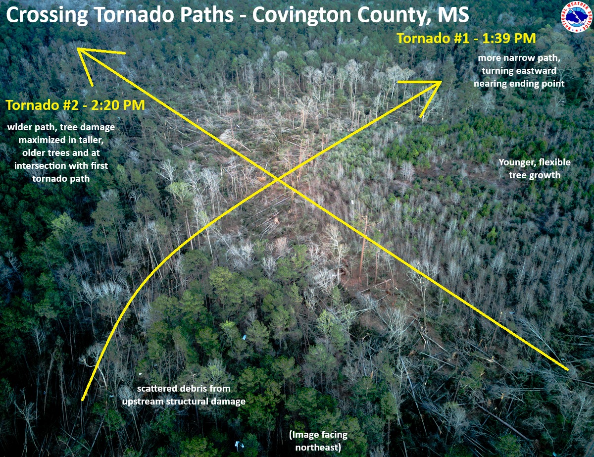
Aerial photo and schematic from the Jackson, Mississippi
National Weather Service office showing how two
tornadoes crossed paths within 41 minutes of
each other earlier this month. 
When there's a large tornado outbreak in the United States, you're almost guaranteed to hear odd stories about the behavior of at least some of those twisters. 

So it was with the swarm of tornadoes that hit on March 14-15.  So far, there have been at least 114 confirmed tornadoes with this outbreak, easily the biggest so far this year. 

Of course, we have at least one weird story about this outbreak. As the Washington Post reports:

"In western Covington County, home too 18,059 people, a pair of tornadoes left a crosscrossing path of damage southwest of the town of Collins, the county seat, in an area just north of Spring Hill School Road.

"......the first one, a dying EF4 that had begun in northern Louisiana, hit the zone around 1:39 p.m. central time. By that point, it had covered more than 67 miles and been on the ground for 1 hour and 22 minutes. 

Then, at 2:30 p.m, and EF2 tornado hit the same spot."

That had to be a pretty terrifying afternoon in Covington County. 

 The explanation, according to WaPo:

"Sometimes the most favorable conditions for tornado formation and maintenance exist in a small zone. When the storms pass through that sweet spot, they can spawn significant long-track tornadoes in rapid succession."

It is weird for two tornadoes to go in two different directions within the same hour, but it can happen.

My guess - and it really is just a guess - is the first one, ahead of a cold front, was associated with a supercell, which typical run southwest to northeast ahead of such a weather system.

The second one hit when the cold front was closer, and the inflow from the front might have helped the second twister to move southeast to northwest, toward the front. 

Luckily, the two tornadoes intersected in a forested area. Though both caused damage, at least nobody's house got hit twice.

OTHER TORNADO ODDITIES 

There have been other examples of large tornadoes crossing paths on the same day, or coming close to it.  This is most common in very large or super outbreaks of tornadoes.

During the famous April 3, 1974 super outbreak of tornadoes, two intense tornadoes passed in close succession  southeast of Flintville, a town in southern Tennessee.

On April 12, 2020, a deadly EF-4 passed just south of Bassfield, Mississippi, followed by an EF-3 that afternoon just north of town. 

There are certain unlucky communities that have been repeated hit by horrible tornadoes. Tanner Crossroads, Alabama was hit by two EF-5 tornadoes on the same day  in that big 1974 tornado outbreak. 

Then in the next big tornado on April 27, 2011, another EF-5 tornado crashed through Tanner Crossroads. It's the only U.S. town known to have been hit by three EF-5 tornadoes. 

EF5's are the worst possible tornado, with winds of over 200 mph.  This type of tornado sweeps houses away completely and pulverizes them. Unless you are in a tornado shelter or a very protected basement, you would not survive such a twister. 

There's also the unlucky city of Moore, Oklahoma, which has been hit by more than 20 tornadoes since 1961. Two of them were EF-5s and two others were EF-4s, the second strongest category of twister.

We have plenty of other examples of supremely unlucky towns in Tornado Alley

UNLUCKY PEOPLE

In Paragould, Arkansas, two tornadoes within less than a year of each other had crisscrossing paths that wrecked the same small group of houses in the Club View Estates neighborhood

One of the homes, belonging to the Drope family, was damaged last May 26 in a tornado.  They weren't able to move back in until a few months later. Then, on March 15, yet another tornado struck the same house, pretty much destroying it. .

This was actually the third time this family endured a tornado. A decade ago, they lived about ten miles up the road from where the remains of their current house is now.  That former home when they lived there was also damaged by a tornado. 

Just this past weekend, Rolling Fork, Mississippi was hit by a tornado. This one could have been worse. It caused some damage, but didn't hit the middle of town, and its winds were "only" about 100 mph.  Bad, but not as bad as it could have been

But Rolling Fork residents are spooked by tornadoes, especially if they hit on March 23, like this one did. It was the second anniversary of and EF-4 that struck the town, killing 17 people and leveling most of the community. 

By the way, the 2023 tornado might have been an EF-5, the worst kind, depending on how you measured it. I had a post on March 24 explaining some quirks in measuring these monster twisters. 

Single tornadoes, or groups of tornadoes in one town can be particularly terrifying. In May, 2007, an EF-5 tornado destroyed Greensburg, Kansas. Then its path performed a loop, crossing its own path and repeating the damage just north of where it had just demolished Greensburg. 

UNLUCKY YEARS

Then there are unlucky years, in which strong tornadoes hit big population centers repeatedly instead of mostly staying in rural areas. The year 1953 comes to mind. It was the only year known to have seen five F5 tornadoes until 1974, when seven such tornadoes hit in just the one Super Outbreak.

Not the Midwest, but a Midwest-
style EF-4 tornado pictured here
struck Worcester, Massachusetts
of all places in 1953, killing 94
and injuring 1,300
The year 1953 featured massive tornadoes hitting larger cities. On May 11, 1953, a huge twister hit downtown Waco, Texas, killing 114 people and injuring 597.

Barely a month later, on June 8, 1953, a F5 tornado hit the Flint, Michigan and surrounding towns killing 116 people and injuring 897. 

The next day, the same weather system move into New England, spawning an F4 tornado in Worcester, Massachusetts and nearby towns, ending the lives of 94 people and injuring 1,300,

More recently, we had the year 2011, which brought the super outbreak of tornadoes on April 26-28 that spun off 360 tornadoes from Texas to New York. The outbreak focused the worst of its wrath on Mississippi and Alabama, which were raked by numerous intense tornadoes. This outbreak killed 321 people. 

Then, less than a month later, an EF-5 tornado struck Joplin, Missouri on May 22. That massive storm killed 161 and destroyed much of the city. 

In total, between those two tornado outbreaks and others, 553 people lost their lives in twister during 2011.     

LATEST ODDITY

Tomorrow, a severe storm outbreak with large hail and even potential tornadoes is forecast in (check notes) an area of the Pacific Northwest encompassing Portland, Oregon and Seattle, Washington, among other cities.

Such an outbreak of severe weather is extremely rare in the part of the nation, but there you go. 

The same storm system threatens to cause a new tornado outbreak in the Midwest, Gulf Coast and Southeast Sunday and Monday. 

Saturday, March 15, 2025

Massive Storm Has Caused Huge Wildfire, Wind And Tornado Damage Already; Could Get Even Worse Today

A home burns in Stillwater, Oklahoma Friday amid 
wildfires that roared through the region. Photo by
Nick Oxford via Facebook. 
After much of the nation endured a day and night of weather chaos Friday, we have more of the same on tap today.  

All thanks to one of the most massive March U.S. storms in memory. 

It started with intense winds, dust storms and wildfires. CBS reports three deaths in Texas involving motorist blinded by dust storms on highways. 

Many highways, including parts of Interstate 35 and 40 were closed in Oklahoma due to crashes, high winds and dust storms.  

At least 50 weather stations in Oklahoma reported winds gusting to  more than 58 mph.  Some gusted past 70 mph.  Amarillo had a peak gust of 83 mph. 

These weren't thunderstorm winds, they were just the power of the parent, intense storm. 

WILDFIRES

The wildfires, sadly, were California style. In other words, tragically destructive. 

No fewer than 150 wildfires were reported in Oklahoma.  One large complex of fires near Stillwater, Oklahoma forced evacuations of numerous homes, some hotels and a Walmart.  At least some homes burned around Stillwater, but we're still waiting on assessment of how bad this one is. "Multiple structures have been impacted," reports News9.com. 

The Stillwater News Press reported multiple homes destroyed in one southwest Stillwater neighborhood.

The fires  were burning houses and other structures elsewhere in Oklahoma, too. About 50 structures burned down around Guthrie, Oklahoma. 

Parts of the Oklahoma City suburb of Norman were briefly evacuated due to another fire on Friday. A wildfire within Oklahoma City limits destroyed two homes

In Texas, another wildfire grew to encompass 12.5 square miles.

TORNADOES

 Severe thunderstorms developed near the Mississippi River late Friday afternoon and the sped east, spinning off tornadoes and severe wind gusts that left a trail of damage. 

Tornado damage in Rolla, Missouri last night. Photo
by Joshua Rogers via Facebook.
We've already had 25 reports of tornadoes and 315 instances of thunderstorm-related wind damage as of early this morning.  

That wind damage doesn't include destruction from the intense winds and dust storms in the Plains yesterday that were nowhere near any thunderstorms. 

Reports are still sketchy and spotty as to how bad the damage was and whether there were any casualties from the overnight tornadoes.

They hit in darkness, so we'll be better able to tell how bad things got after dawn. 

We know there was a lot of tornado damage in towns like Rolla, and Villa Ridge Missouri and Cave City, Arkansas and Elliott, Mississippi. Photos on social media showed a large tornado lit up by lightning late last night near Belzoni, Mississippi. A traffic camera near Campbell Station, Arkansas spotted two simultaneous tornadoes nearby. 

TODAY

The tornado situation is actually going to worsen today.

As the day started, tornado watches were already in effect from southwest Ohio down to Mississippi and Alabama.

In the South, this early round of severe weather is just a foretaste of what's to come. 

Alabama and Mississippi are in a  rare high risk zone for tornadoes this afternoon and evening. That's the first time in four years this tornado-prone region has been designated a high risk for twisters.

Forecasters fear the region will be hit be a series of violent, long-lasting tornadoes. This looks like it could get off to an oddly early start today and last all day.  Already, NOAA's Storm Prediction Center is contemplating issuing a new tornado watch for much of Louisiana and northwest Mississippi as this new, dangerous round of intense storms begins to develop

The risk of this happening is almost as high as well in parts of Georgia, Tennessee and eastern Louisiana. 

On top of everything else a large area in Tennessee and surrounding states are under the gun today for widespread, life-threatening flash floods.  Some areas could see six inches or more of rain, with rainfall rates of up to two inches per hour. 

VERMONT EFFECTS

Here in Vermont, the main risk from this storm continues to be flooding. At least minor flooding looks inevitable. The most likely time frame for this would be from late Sunday afternoon through most of Monday.

We'll prime the pump as it were today with warm temperatures in the 60s in many areas of Vermont. That will get rivers starting to rise, but the main show won't happen until later Sunday. 

By Sunday evening, the remaining snow will have been melting fast amid oddly warm, humid air. A band of showers and possible thunderstorms should come through Sunday night, adding another half inch to an inch of rain to all that snowmelt runoff.

We're starting to get the first flood forecast outlooks for specific rivers in Vermont. Though subject to change, these forecasts call for minor to at times moderate flooding. For instance, the forecasts have the Mad River at Moretown at the cusp of moderate flood stage Sunday night. Forecasts also have the Missisquoi River at North Troy approaching moderate flood state Sunday night. 

Even though the thawing today and Saturday could weaken ice in spots, the risk of more ice jam flooding is definitely there on some rivers. I'm especially watching the WInooski, Lamoille and especially the Missisquoi for that possibility. 

STORM IN PERSPECTIVE

Given the breadth of this almost nationwide storm, the destruction that's already occurred and the inevitable severe damage we'll see today, this will be yet another mega storm that costs more than $1 billion in damage.

Large, multifaceted storms are pretty common this time of year, but this storm is an especially extreme case. It's hitting an even wider area than most early spring storms, and its effects are even more intense than the usual March storms that bluster through the Midwest and East. 

I can't specifically blame climate change for this storm's intensity because I don't yet have enough information about the dynamics of this system. However, it's consistent with climate change in that storms tend to be more intense, windier and in many cases wetter than they would otherwise be had the world not been warming. 

This storm has already taken lives, and I'm afraid it will take quite a few more before it's over. Meanwhile, with foolish cutbacks in staffing and services from NOAA, the National Weather Service and FEMA, there might well be some unnecessary deaths with this storm, and almost certainly some unnecessary suffering. 


Monday, November 4, 2024

Oklahoma Continues To Have An Extremely Rough Autumn. Today Will Be Third Day In Row With Tornadoes

Huge board pierced this car in this weekend's 
Oklahoma tornadoes. Twisters can fling things quite a
ways, as was the case here. Notice the lack of 
damage in the background, this board was ejected
some distance from the tornado.
Saturday night and early Sunday, Oklahoma endured a series of intensely destructive tornadoes.

Sunday and Sunday night, a new round of tornado warnings blared across the state amid clusters of severe thunderstorms and flooding downpours. 
'
An even more widespread outbreak of tornadoes and severe weather seems likely today in Oklahoma, northern Texas and western Arkansas. 

The tornadoes early Sunday focused on the southeastern part of the Oklahoma City metro area, hitting Newcastle, Moore, Valley Brook and Hurrah.  You might recognize a couple of those towns as seemingly always being hit by tornadoes, so I guess it happened again. 

This time, eleven people were taken to hospitals with tornado-related injuries. Dozens of homes were damaged or destroyed.  Other storms produced damaging straight line winds and flash flooding. 

Sunday afternoon, tornado warnings blared around Oklahoma City again, as severe thunderstorms and additional flash flooding. More than four inches of rain poured down on Oklahoma City Saturday night and Sunday. 

Today, if anything looks potentially worse.  The area under the gun for severe weather is more widespread than it has been for the past two. The atmospheric at least as of this morning look favorable for a variety of hazards including tornadoes, a couple of which might be quite strong, intense straight line winds, large hail and flash flooding.

In anticipation of the bad weather, dozens of Oklahoma schools and some colleges have canceled classes today. Oklahoma Municipal Court has also canceled sessions today. 

Already, this morning and early afternoon, there's been a couple of tornado warnings in Oklahoma, and that's ahead of the main show expected this afternoon and evening. 

Tornado and severe thunderstorm outbreaks are usually creatures of the spring and summer. Strong storm systems combined with strong daytime heating from the sun combine to create those big storms in the spring.

However, there's sometimes a smaller second season in the fall.  The sun's heating is pretty lame this time of year. But storm systems are stronger this time of year than in the summer. That strength  can overcome the weak daytime heating to produce dangerously stormy weather. 

What makes this situation unusual is that the rough weather has been sitting over or near Oklahoma for three days, if you count today. 

Usually, autumn storms that produce severe storms and tornadoes are in and out quickly. You get a  round of damaging storms on one day, and the next that storm system is hundreds of miles to the east. 

This storm will finally move on tonight and weaken as it moves east, greatly diminishing the severe storm and tornado threat 

This time is different. 

Less than 24 hours after tornadoes in Oklahoma metro area, mid-afternoon severe t-storm warnings: 


Sunday, November 3, 2024

Late Season Burst Of Tropical Storms; Southern Plains Battered By Tornadoes, Rain Steadfastly Avoids Northeast

That disorganized swirl of clouds between Cuba and
South America in this morning's satellite view
could eventually become Tropical Storm Rafael.
 UPDATE 5 PM SUNDAY:

Late this afternoon, the National Hurricane Center designated that disturbance in the western Caribbean as "Potential Tropical Cyclone #18".

The reason is, this thing has gotten a noticeable circulation since this morning, bringing it closer to tropical storm status.

It wasn't quite there yet, so the NHC is still calling it potential.

By morning, I'm pretty sure it will be officially Tropical Storm Rafael.

Forecasts are pretty bullish on this thing.  It's expected to become a hurricane.

It should be a strong tropical storm by the time it brushes past Jamaica Tuesday, and a hurricane Wednesday when the Cayman Islands and western Cuba deal with it.

From there, it's expected to move north or northwestward into the Gulf of Mexico where it faces a very uncertain future.

PREVIOUS DISCUSSION 

The strange, busy 2024 Atlantic hurricane season is giving one last hurrah, with two systems now roaming out there. 

Meanwhile, the southern Plains keep getting battered by storms and the Northeast still seems to have a steadfast anti-rain shield.

TROPICS

Subtropical Storm Patty formed west of the Azores a couple days ago, and then moved eastward into those islands yesterday and overnight. 

It's subtropical, not Tropical Storm  Patty because it has the characteristics of both a tropical and non-tropical system.

  It's got a warm core like a tropical storm but it's formed within a larger storm system with a colder center, which is what you normally see with a non-tropical storm.

Patty's winds peaked at 65 mph yesterday and it's now weakening.  It's forecast to become a remnant low that'll hit northern Portugal and northwestern Spain toward Tuesday.  It won't cause too many problems there. Which is good, since Spain is reeling from that epic flood in the Valencia region on the opposite end of the nation. 

Patty is the ninth named tropical or tropical type storm to form in the Atlantic since September 24. That ties with 1950 as the most such storms to form in the Atlantic after that date in September. 

But wait, there's more! 

The real trouble is brewing in the northwestern Caribbean Sea. That area has been monitored for more than a week for signs of a tropical storm. The area of disturbed weather is finally getting its act together and is likely to become Tropical Storm Rafael within the next couple of days. 

If a tropical storm forms in November, this is the place they usually start.  The water temperature down there is still super warm, and it's too far south for autumn cold fronts to disrupt attempts at development. 

Early indications are Wannabe Rafael will try to move north and threaten Jamaica, Hispaniola or Cuba. It could even reach hurricane strength. 

Once Wannabe Rafael gets past Cuba, all bets are off. The early thinking is it will end up in the Gulf of Mexico, but will it eventually hit the United States and if so, where?

We don't know. Also. Wannabe Rafael could hit a hostile environment in the Gulf of Mexico. The gulf is far enough north to see those autumn cold fronts this time of year. A front like that would bring dry air and strong upper level winds, which would tend to rip a tropical storm or hurricane apart.

Then again, it's still possible for a hurricane to make landfall in the United States in November. It happened with Hurricane Kate back in 1985 and Nicole back in 2022, both of which hit Florida. So we'll see. 

Even if it's a weak system Florida does not need another hurricane or tropical storm this year after the damage and heartache Debby, Helene and Milton caused. 

Believe it or not, some forecast models depict another tropical storm or hurricane in the Caribbean around November 19-ish. However, those long range models very often create phantom forecast hurricanes that more often than not never form, so that that November 19 idea with a tremendously large grain of salt. 

SOUTHERN PLAINS

Storm chaser Nick Smith documented this severe
overnight tornado damage in Harrah, Oklahoma,
just east of Oklahoma City. 
The overall weather pattern is stuck, so storms keep hitting the southern Plains and that state of affairs seems like it will continue for awhile. A handful of tornadoes were reported in Oklahoma and Texas yesterday. 

Tornadoes around Oklahoma City damaged several homes and caused at least six injuries, television station KOCO reports. 

More severe weather and possible tornadoes are expected in the same region later today and especially tomorrow. 

Torrential storms caused flooding in what had been drought-stricken parts of Oklahoma overnight. More flooding is possible today and tomorrow. 

That rain is not heading east, so the drought-stricken Northeast will continue with its long stretch of parched ground and wildfires.  

Sunday, May 26, 2024

As Sadly Expected, More Tornado Tragedies Saturday; 15 Dead So Far, More Tornadoes Now Spinning In Midwest


The Denton, Texas Fire Department released this
photo of tornado damage in their city. Major
damage and some deaths were reported from 
overnight tornadoes in Texas, Oklahoma and Arkansas
UPDATE, 6:30 PM

Since this morning, the death toll from last night's tornado swarm rose to 15, making this easily the worst tornado outbreak in a very busy and tragic season.

Even worse, the developing tornado situation in the mid-Mississippi has gotten worse, as NOAA' Storm Prediction Center upgraded the storm risk this afternoon to moderate, the second highest level. 

Several strong to intense tornadoes are likely this evening in that region, says the Storm Prediction Center. 

Already, as of 6:30 p.m. several tornado warnings were in effect in Missouri.  Numerous severe thunderstorm warnings were also up for a zone from Arkansas to Ohio and western Pennsylvania.

A "particularly dangerous tornado watch is in effect for big chunks of Missouri, Illinois, Arkansas, Kentucky and Tennessee. A "particularly dangerous" watch means forecasters are confident there will be strong tornadoes, and perhaps many of them. 

PREVIOUS DISCUSSION

Tornadoes again swept the southern and central Plains yesterday afternoon and night, unleashing more damage, deaths and destruction in a remarkably busy and heartbreaking tornado season.  

At least 24 tornadoes were reported Saturday and more are expected today. 

CNN was reporting five deaths from tornadoes in Texas overnight. 

At first, it began to look like the worst of the expected Saturday outbreak wouldn't come to pass. Only a few fitful tornadoes were reported during the day in the southern Plains. Then, after dark, supercells really exploded, unleashing the barrage of tornadoes.

Tornadoes are much more dangerous after dark as you can't really see them coming, and people are not as likely to be paying attention to warnings. 

Likely the worst incident came Saturday night when a  tornado smashed through a travel center housing a gas station and a few restaurants off a busy highway in Valley View, Texas, television station WFAA reported.

About 80 people were in there at the time, some of whom stopped there for shelter when they heard tornado warnings in their cars. Most of the people inside were injured, authorities said, but none of the injuries are life-threatening.

However, elsewhere around Valley View, at least two people, and possibly more died when the twister roared through neighborhoods, WFAA reported. The dark of night and power outages hindered search and rescue, and officials said they feared what they would see when dawn broke. 

Valley View is along Interstate 35 about 60 miles north of Dallas. Heavy damage was also reported in nearby Celina, Texas, probably from the same tornado. 

An intense supercell spun off a series of destructive tornadoes overnight and early this morning over 220 miles or so from Claremore, Oklahoma to Briarcliff, Arkansas. 

Details were still sketchy this morning, but at least two deaths were reported near Claremore, which suffered heavy damage. Possible tornadoes hit an outdoor wedding in Capron, Oklahoma and a KOA campground near Claremore. Initial reports indicate injures are minor at the campground 

Widespread damage is also reported in Rogers, Arkansas. 

I'm sure more sad details will emerge as we go through the morning

TODAY

Tornado warnings were still flying as dawn broke in northeastern Arkansas and southeastern Missouri. 

A whole large area through the mid-Mississippi and Ohio valleys are under the gun for tornadoes, damaging straight line winds and large hail pretty much all day.

After tomorrow, the national tornado threat should wane, but not entirely go away, for at least a few days.  

For those here in Vermont wondering how that storm will affect us, we only need to deal with showers and non-severe thunderstorms Monday afternoon and night. 


Tuesday, May 7, 2024

Parts Of Oklahama Reeling From Tornadoes, Storms, Action Moves East Today

Early reports suggest that much - but not all - of Oklahoma escaped the wrath of expected powerful tornadoes yesterday and last night, but some towns there were devastated.  

Awful scene from tornado ravaged Barnsdall, Oklahoma
last night. Photo from Aaron Rigsby, @AaronRigsbyOSC

Details are just emerging, but it sounds like two communities in particular - Barnsdall and Bartlesville in northeast Oklahoma took terrible hits from one nighttime tornado.

The smaller of the town towns, Barnsdall, population about 1,000 appeared to suffer catastrophic damage, with leveled houses and debris scattered everywhere.

 Radar images at the time of the tornado showed debris from Barnsdall lifted up to 30,000 feet into the air. 

At least one person was reported dead in Barnsdall, and numerous people were injured, CNN is reporting. The tornado took a path very similar to another twister that hit the town about a month ago. 

The tornado moved on to the larger city of Bartlesville, population around 38,000. Details are still sketchy early this morning but there appears to be a lot of damage there, too. Video shows frightened people taking cover as the tornado slams into a Hampton Inn. It looks like the people staying there escaped injury, but the roof is gone and hallways were littered with debris.

In all, we so far have 17 reports of tornadoes yesterday and last night, mostly in Oklahoma. The state overall fared better than expected, as some forecasters feared more widespread damage. The Oklahoma City metro area was largely spared, though thunderstorm gusts to at least 64 mph were reported there. 

MORE THREATS

Like in most tornado outbreaks, Day 1 is just the start. We have at least two more days, possibly three this week to go before the threat of severe weather diminishes at least temporarily. 

Today, it's Indiana and Ohio's turn. For some reason Ohio has been the most frequent target of tornadoes so far this year. That's despite the fact their tornado season usually peaks in May and June. 

A couple of the tornadoes could be strong in Indiana and Ohio today, so it's definitely eye to the skies. 

On Wednesday, the threat area is even broader. The main area of concern extend from northeast Texas through the mid-Mississippi Valley on through Kentucky and, yes, southern Ohio again. 

A marginal risk of severe storms extends northeastward Wednesday all the way to southern Vermont. Here in Vermont, no tornadoes are expected, but there could be a couple isolated reports of damaging wind or hail, roughly along and south of Route 4. Definitely iffy for us, and nothing nearly as widespread as in the Midwest. 

Northern Vermont will definitely see showers and maybe a rumble of thunder, but nothing severe. 

On Thursday, the severe storm and  tornado threat shifts south, with a band of severe storms and possible tornadoes extending from Texas, through the Gulf Coast states, then up the Eastern Seaboard as far north as Washington DC. 

Monday, May 6, 2024

Update: Kansas, Oklahoma REALLY Under The Gun For Tornadoes Today

Dangerous day in the central Plains today. The moderate
risk zone later got an upgrade to high risk as 
forecasters fear there might be intense, long
tracked tornadoes in this region later today. 
UPDATE: 

After I wrote the narrative below, NOAA's Storm Prediction Center issued a high risk zone - the highest severe storm and risk category - for parts of central and north central Oklahoma and south central Kansas. 

Cities under the high risk are Oklahoma City, Norman, Moore, and Norman, Oklahoma.

Moore already has an ugly history with tornadoes, having suffered two EF-5 twisters, the most intense and dangerous kind, since 1999. Moore has also had other, less intense tornadoes in that time frame.

Norman is the headquarters for Storm Prediction Center, which manages severe weather and tornado dangers. The local National Weather Service office that covers a broad swath of central Oklahoma is also located in Norman. 

PREVIOUS DISCUSSION

As I highlighted on Saturday, the threat of tornadoes in the middle of the nation ramps up today. It's worth an update because tornado experts are definitely more nervous than usual. 

THE FORECAST

The chances of particularly intense, long lasting and highly destructive tornadoes is if anything higher than it was back on April 26 and 28 when more than 200 tornadoes caused intense destruction in Iowa, Nebraska, Oklahoma and Kansas. Five people died in that outbreak. 

It's unknown whether there will be that many tornadoes this time, though the risk of quite a few tornadoes lasts from this afternoon through Thursday in parts of the Plains, Midwest, Southeast and East Coast.  

Updated map showing high risk tornado and severe
storm area today in Oklahoma and Kansas.

 For now, NOAA's Storm Prediction Center has all of central Oklahoma and southern Kansas in a moderate risk of severe storms and tornadoes today. That's the second highest alert level on a five point scale, but meteorologists point out it's sort of at the top end of  a moderate risk. 

"Multiple intense, long-track tornadoes are expected, especially in parts of southern Kansas into Oklahoma," the Storm Prediction Center, or SPC said in its early Monday morning forecast assessment. 

 The SPC toyed with the idea of upgrading the moderate risk designation to high risk, the most intense alert level. However, as of early this morning the meteorologists at the center still had some questions as to how many intense tornadoes will develop today. 

(EDITORS NOTE: As the update above says, the SPC has decided to go with a high risk alert for tornadoes today in parts of the region, given the favorable environment for strong, long-lasting tornadoes.)

Those meteorologists left the door open to declare a high risk day with updates later this morning. 

High risk severe storm and tornado designations are rare, usually happening on average just once a year. Some  years have none, and others have a handful. The last time the Storm Prediction Center issued a high risk alert was on March 31, 2023. 

That resulting outbreak last year resulted in 136 tornadoes with 23 deaths. 

For today's outbreak, I guess the best hope is that any strong tornadoes that do form avoid large towns and cities, and stay in open country instead.

Metropolitan areas most at risk this afternoon and night are Oklahoma City, Tulsa, and Lawton, Oklahoma and Wichita, Kansas.  The risk of tornadoes extends well south, north and east of these cities.

ADDED RISKS

Here's a couple more reasons to be worried about this likely tornado outbreak. 

The threat continues well into the night, after dark. Nighttime tornadoes are in general more dangerous than those that hit during the day. Although you should take shelter immediately when hearing a tornado warning, people tend to seek visual confirmation that a twister is coming. 

You don't see approaching tornadoes nearly as well at night, so some people might try to take shelter too late, when the tornado is upon them. Also, people might be sleeping or otherwise unable to hear warnings. 

Since this promises to be a particularly big outbreak, hordes of storm chasers are now converging on Oklahoma and Kansas. While most (but not all!) experienced storm chasers are pretty safe, many amateurs don't know what they're doing and can get in real trouble. 

They don't get out of the way in time, or they drive recklessly to get near a tornado, or clots of chasers clog roads, blocking escape routes for others. 

STORM FATIGUE

This has been a particularly busy tornado season. According to preliminary figures, the nation has already seen 586 tornadoes this year as of this morning. At least 300 of them hit in April.

The national death toll for tornadoes so far in 2024 is relatively low considering how many twisters we've seen. So far 13 people have lost their lives in tornadoes this year. 

We can only hope that our relative good luck on that score continues. An excellent warning system has kept the deaths low compared to past storms. But there's no guarantee that will continue. 

I'm sure people in the Plains and Midwest are sick of tornado warnings, too, as there have been so many. 

It'll continue past today. 

Tuesday, the tornado risk zone shifts to places in and near the Ohio Valley. Wednesday, a huge area centered on the middle Mississippi Valley is under the gun, then it's the middle and southern Atlantic coast and Texas that deals with the rough weather on Thursday.

Up here in Vermont it'll be showery off an on Wednesday through Sunday, with nice dry breaks in between. We will escape the severe weather. At this point the worst we can expect is a possible rumble of thunder and a brief downpour or two later in the week. All good.  


Thursday, May 2, 2024

Gross! Oklahoma Municipal Public Tornado Shelter Was A Dangerous Cesspool.

Residents of Sulfur, Oklahoma in a
municipal storm shelter in foul water
and broken chairs as a tornado
roared through the city. Incident
shows public storm shelters should
be maintained, inspected to ensure
public safety in storm emergencies. 
 One of the worst hit towns in last weekend's tornado outbreak was Sulfur, Oklahoma, where the downtown was largely destroyed, as were numerous homes. 

Not everybody has a storm shelter at their house, so many - but not all - towns and cities in Tornado Alley have public storm shelters where anybody can go to seek protection from dangerous tornadoes. 

However, Sulfur was a case study in what happens when a city doesn't maintain a storm shelter. 

People who arrived at Sulfur's storm shelter had to go down a steep flight of stairs (normal) only to find three inches of foul water on the floor and unsafe, broken chairs.  

Because repeated waves of tornado-warned storms passed over or near Sulfur Saturday night, people who sought shelter in this awful place had to stay there for three hours. For the elderly and disabled, standing for so long is an impossible order. 

One group of people - including one in a wheelchair - arrived at the storm shelter only to realize they couldn't get down there as the tornado bore down. At the last second, the group was able to get into a hotel just as the tornado began ripping downtown Sulfur apart. 

Laura Carter, a private caregiver, was in that group, told 2 News Oklahoma: "There's three inches of water that they are standing in for hours....Most of the people that are down there are in sandals or barefoot, and the chairs that are down there are rusted and falling through. They're falling through, they don't even have a place to sit for hours, as a tornado is ripping through our town."

Carter continued: "I ran into a city worker the other day who was actually down there helping us, and I asked, I was like, 'has the shelter always been flooded like this?' He said, 'Yes ma'am, our boss told us last year to go down there and pump all the water out and just leave the rusted chairs down there. I highly doubt we'll ever have to use them.'"

Famous last words, indeed. 

For any weather emergency, if there's a low cost way to protect the public, there should be one, even if the chances of actually having to use it in any given year are low. In Oklahoma's case, not everybody has access or can afford their own tornado shelter, so these municipal ones can save lives.

The television station says towns surrounding Sulfur have workable municipal storm shelters. 

As for Sulfur, the city has since condemned the terrible storm shelter as unsafe. Local residents and activists plan to lobby for a new, better one for the next time. 

I just hate to think what would have happened to someone who, grossed out by this storm shelter, left to seek another one, but ended up getting run over by the tornado in the process. 

 I hope Sulfur never gets hit by another tornado like this. But I also hope they build a safe, clean public storm shelter,  just in case.