Wind chills from a strong Arctic high pressure system were down in the single numbers and teens this morning. Actual temperatures this morning were near 20 and will barely budge despite the first sunny weather we've seen November 29.
By tomorrow morning, temperatures in much of Vermont will be down within a few degrees either side of zero.
The winter cold and the sun are big clues as to what will happen with that highly advertised nor'easter that's about to strike much of the Mid-Atlantic and northeast.
The frigid air is a sign that Arctic high in Quebec is strong, helping to shunt the storm south of us. The sun is a sign that this cold air is dry. That means any moisture from the storm that tries to work its way north will probably evaporate en route, robbing the Green Mountain State of any real snowfall.
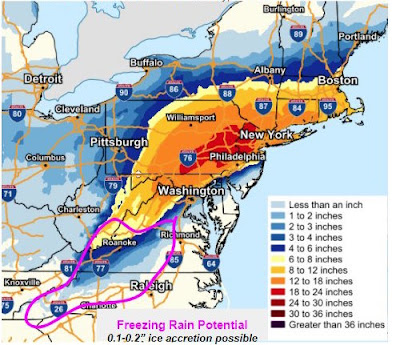
Oh, sure far southern Vermont still looks as if it's close enough to perhaps get a few inches of snow out of this. It's possible that area could still get a nice big dump. Some computer models have moved the heavy snow northwestward into the southern Green Mountains, but others keep the snow there pretty light. Time will tell.
Current forecasts have flurries reaching as far north as the Canadian border. Other models stop the flakes at about Rutland. The storm's cloud shield will overspread the entire state on Wednesday, dimming or blocking out the sun and ensure it stays really cold for a few days.
For now at least, Vermont will probably mostly be a bystander to this event. At least forecasting this storm is relatively easy for us.
I feel no envy for any meteorologists near Philadelphia, New Jersey, the New York metro area and Long Island.
Right along the coast, it seems like enough warm air would intrude to cause mix precipitation or even a period of cold rain.
 |
| Covid era outdoor dining in New York City in the coming days? Alas, the city has stopped outdoor dining to make way for the snow plows. |
There will be a distance of maybe just a dozen miles between an icky wet mess of slush and ice and deep powdery snow. Where that sets up is anybody's guess.
If any given meteorologist is off by just five miles in their predictions of where the snow and mix line sets up, their forecast will end up being totally wrong.
It's really impossible to forecast that accurately, so some people in this highly populated area are going to be surprised one way or another.
All those millions of people from Roanoke, Virginia to Boston, Massachusetts can expect a very disruptive storm. Needless to say, travel is not recommended in these areas tomorrow and Thursday.
In New York City, where more than six inches of snow is currently forecast, the hurting dining industry is receiving a double whammy. The state has reimposed a ban on indoor dining due to a spike in Covid. Brave restauranteurs have continued outdoor dining despite the chill. But now that's banned for now to make room for the snow plows.
There is still time for a shift in the storm's forecast strength and path, so adjustments are going to happen.
Back here in Vermont, our spell of midwinter cold will ease by the weekend, as we get back up into the 30s in the daytime.


No comments:
Post a Comment