 |
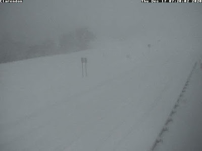
| Web cam on Route 7 in Clarendon, Vermont, just south of Rutland, shows pretty much white out conditions amid a nearly stationary snow band at around 7:45 a.m. today. |
Same can generally be said for other forecasts in the Northeast, though some of the snow amounts were way off the charts, much more than even the impressive forecasts indicated.
A good chunk of southern Vermont is closing in on two feet of snow, so this storm really over performed there, too.
There are reports of more than three FEET of snow in southwestern New York near Binghamton and into parts of Pennsylvania. Litchfield, Pennsylvania reported 40 inches of new snow. A spot just southwest of Binghamton got 41 inches.
Some of the snowfall rates were amazing. Reports from Pennsylvania and New York told of five inches of snow per hour, with 15 inches piling up in just three hours.
The culprit was a well-advertised band of especially heavy snow that pivoted through Pennsylvania, parts of New York and on into southern and central New England. That was the forecast, anyway.
 |
| Incredibly deep snow this morning near Binghamton, NY Photo via Twitter @lisapr1113 |
There was a question of whether and how deep into southern Vermont that snow band would get. It did lift through southern Vermont reaching a spot just south of Route 4 before dawn this morning. It looks like it won't get any further north than that.
This band of heavy snow stalled out in southern Vermont this morning, but still produced some impressive snow. Early reports indicated 21 inches in Reading, Vermont and 18.8 inches in Windsor.
Do note it was still snowing pretty heavily in these places, so we'll get more impressive totals as the morning goes on.
The forecast for the northern extent of the snow was spot on. The meteorologists figured the snow would reach up to Route 2, but not too far beyond that. You can see how the snow diminishes as you work north.
So far, Castleton, west of Rutland, had eight inches. There's two to four inches in Addison County. Photos on social media early this morning showed an inch or two around Burlington.
As the morning goes on, the snow will pivot east and eventually end. Needless to say, travel is NOT recommended in southern Vermont this morning with that heavy band. Roads are tricky through most of Vermont except the far northwest corner.

No comments:
Post a Comment