 |
| Springtime in December. Honeysuckle vine leafing out in my St. Albans, Vermont garden yesterday amid record warmth. |
Temperatures, at least for awhile, were at mid-May levels. Convective showers and even thunderstorms, the kind you'd expect later in the spring and not December, roamed about.
And we had dramatic views of clouds, sharp sun and rainbows. It was a terrific - and comfortable - day to be outdoors, watching the skies.
Burlington reached a record high for the date of 66 degrees, besting the old record set in 1934by two degrees.
Montpelier managed to break its record high for the date before dawn. There, it was 60 degrees, beating the only record set in 1991 .
St. Johnsbury clocked in with a record high of 65 degrees, beating the old record set in 1934 by two degrees.
While this record warmth bathed Vermont, not too far to the west - in western New York, it snowed all day. Go figure.
 |
| A first for my property in St. Albans, Vermont. A flower buds in my garden amid record warmth |
You do sometimes get a lightning strike or two in an intense snow squall or strong nor'easter passing by, but even that rarely happens this time of year.
What we got Tuesday was almost summertime thunderstorms. Small hail was reported around Montpelier.
I noticed several flashes of lightning from my viewpoint in St. Albans, Vermont, as a late afternoon thunderstorm rumbled northward through the northern Adirondacks of New York.
The parent storm system that caused this pulled subtropical air from the Gulf of Mexico and Atlantic waters off Florida all the way north to New England, which caused the unusual warmth.
Storms that aren't hurricanes have cold cores. As the storm edged closer to us, the air aloft cooled first. The contrast between the very warm surface air the the chilly air higher up created a lot of instability, which helped fire the odd showers and thunderstorms.
 |
| Spring-like convection fires up southwest of St. Albans, Vermont Tuesday amid record warmth on December 1 |
Still, temperatures were in the mid-30s, which is kind of mild for early morning this time of year.
Snow showers will pick up steam this afternoon, but might mix with rain in the lower valleys. We actually might end up with a dusting to two inches of snow out of this, at least in some areas.
It will stay relatively mild, but nothing like Tuesday, into Saturday.
Then, as they say, the weather could get "interesting."
"Interesting," as the National Weather Service office in South Burlington put it in their Tuesday afternoon forecast discussion, usually perks up my ears.
It seems another fairly decent storm - though not as strong as the one that affected the East Monday - will head north along the Eastern Seaboard.
 |
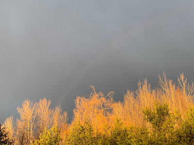
| A faint rainbow, dark storm clouds and a shaft of bright sun lights up the trees on an odd weather day, yesterday, December 1, in St. Albans, Vermony |
Temperatures will be marginal, too. Which means if we do get this storm, valleys could see more cold rain snow.
All this would happen Saturday night and Sunday, so stay tuned. We'll have some clarity on this possible situation I hope by Friday.
I've been hinting that winter would finally arrive, at least for now, and it does look like that. It looks like next week will feature seasonably cold weather with chances of snow here and there
Seasonable means highs in the upper 20s to mid 30s and lows in the teens and low 20s this time of year. If you didn't bask in those periods of warm spring sunshine on Tuesday, you missed your chance.

No comments:
Post a Comment