
 |
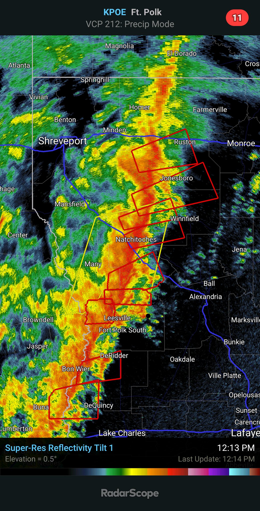
| Squall line in Louisiana yesterday. All the little red squares you can see in there are tornado warnings |
More on the wildfires in a bit, but the even bigger weather news was the severe weather, which played out pretty much as expected on Wednesday. ..
Most of the violent weather was along a violent squall line that spend the day traveling from Texas through Alabama.
It always seems people like me foist a "new" weather term on the public, and we have another one for you.
During Wednesday's outbreak of severe weather in the South, one of the predominate hazards was something called QLCS tornadoes.
It sounds like some weird weather secret code but the abbreviation stands for Quasi-Linear Convective System.
Most of the photogenic big funnel tornadoes you see on the news and in storm videos are borne from supercell thunderstorms. Supercells are rotating thunderstorms that don't have a physical connection to other thunderstorms that might be in the area. They are big, independent suckers.
QLCS tornadoes form along a line of connected thunderstorms. The line of storms are usually oriented north to south and the whole line tends to move eastward.
These lines of storms often have kinks in them, where a piece might try to outrun other storms, or another storm might try to lag behind others.
When the atmosphere is such that winds change speed and direction with height, tornadoes can form around these kinks or bends in the line of thunderstorms.
These so called QLCS tornadoes are usually, but not always weaker than the biggies that come from supercells. The QLCS tornadoes often spin up very quickly then die out fast, too, which makes it hard for meteorologists to send out timely warnings.
Yesterday, there were so many potential spinups that at least 120 tornado warnings were issued. Not all of the rotation in the air that prompted the warnings actually resulted in tornadoes, but it's clear a fair share touched down.
That's especially true in Springdale, Arkansas, around Jackson, Mississippi and southwest of Birmingham, Alabama, where there were reports of quite a bit of damage.
We have a preliminary count of about 30 tornadoes from this squall line. However, National Weather Service meteorologists will need to go out over the next few days and tease out whether damage in any particular spot was caused by a tornado or straight line winds.
For instance, if all the trees in a particular area fell in the same direction, that was probably straight line winds. If the trees fell in different directions, that would likely indicate tornado damage.
WILDFIRES
This has already been a bad wildfire year for the United States as a whole. On Wednesday, a new area was hit.
At least 35 buildings, mostly homes and vacation cabins were destroyed in a wildfire that roared through rugged terrain around Pigeon Forge, Kentucky.
Strong winds and dry vegetation helped spread the fire quickly. Lighter winds and rain today should help.
Another fire in Gatlinburg, Tennessee prompted evacuations, but firefighters stopped the flames before they reached any homes. Gatlinburg was hard hit in 2016......
VERMONT
As advertised, all this rough weather is pretty much avoiding us. A little mixed precipitation raced through overnight, but didn't amount to anything.
A quick surge of warm air today will probably bring temperatures above 60 degrees in parts of Vermont today, especially west of the Green Mountains.
Severe storms are possible along the East Coast today.
NOAA's Storm Prediction Center does have a marginal risk of severe storms all the way to the Canadian border in New York State, and as far east as the state's border with Vermont. h Marginal risk means there's a chance of a brief, isolated episode of damaging winds here or there.
In Vermont, it's possible we'll hear a rumble or two of thunder, and it could get a little gusty under the line of showers and storms as they come through the state tonight, but there shouldn't be any widespread trouble.
Cool and showery weather will return tomorrow, and kind of average weather for early April will continue Sunday through Wednesday at least.
No comments:
Post a Comment