
 |
| Overall National Weather snowfall prediction map hasn't changed much since last night. Heaviest snow to be in northern Green Mountains/Northeast Kingdom. Lighter amounts in parts of Champlain Valley. |
It was still above freezing with patchy rain in the rest of Vermont at dawn, but that quickly changed. i I noticed Burlington reported moderate rain at 6 a.m., but flipped to snow shortly after that.
Places where it's raining or just cloudy in Vermont early this morning will flip to snow as the morning wears on.
Although picky details on the storm are still shifting a little, the overall forecast is nearly the same as it was last evening. We'll get a quick, heavy thump of snow, which will start wet and heavy this morning and then turn more powdery through the afternoon as temperatures plunge.
It's still looking like the heaviest snow for most of us will come down from mid-morning to early afternoon northwest, and lasting well into the afternoon east.
Winds will pick up as temperatures drop, so this afternoon is going to be especially awful on the roads. I'd stay home. The wet snow will compact into ice by tires, making it difficult for plows to remove. Then we'll have lots of snow and blowing snow covering all that ice up, making things even more slick. Visibility will plummet in the snow and blowing snow.
In some parts of northern Vermont, the National Weather Service in South Burlington says near blizzard conditions could briefly develop when the heavy snow and high winds overlap for a time today. There's no blizzard warning in effect because the nastiness of the weather probably won't last long enough to make it an official blizzard. Plus the spots that receive those awful conditions will be fairly limited.
We still have to worry about power outages, especially where temperatures stay near the freezing point longest. That's probably in southern and eastern Vermont.
The strong winds expected later today will certainly make the potential for those power failures go up. It could end being a long night for Vermont's electric utilities and their repair crews.
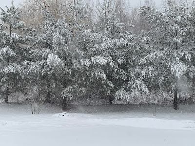 |
| 1.6 inches of wet snow in St. Albans, Vermont as of 8 a.m. Saturday starting to weigh down these pine trees. |
Even in northern Vermont, there could be isolated gusts to 60 mph on the east slopes of the Green Mountains tonight, which could cause issues. Most of us will see gusts at least to 40 mph.
The National Weather Service is sticking with a general 6 to 10 inches of new snow for most of us. Places right along Lake Champlain and areas near Brattleboro will likely get a little less than that.
The snow will taper off west to east later this afternoon for most of us, but keep going well into the night along the western slopes of the Green Mountains. The storm will have largely departed by evening, but those strong northwests winds riding up and over the Greens will keep dumping snow on those western slopes.
Some of the northern Green Mountains will end up with a foot or more of snow due due to what many are calling the "bonus" snow at the end of the storm.
With temperatures bottoming out near 10 degrees by dawn Sunday and wind chills below zero, the snow cleanup at the start of the day won't feel all that happy.
The forecast for one more wintry day on Sunday is staying solid. It'll be windy most of the day, but you'll notice those gusts diminishing during the afternoon. Highs will be in the 20s. That's quite cold for this time of year, but nowhere near any records. (The lowest high temperature on record in Burlington for Sunday is 16 degrees, and we'll easily blow past that).
Spring is still on schedule to return Monday, reluctantly at first, then more enthusiastically as the week goes by.
Monday afternoon will get into the low 40s to start melting the snow. Tuesday, a week cold front might keep readings down into the 37 to 42 degree range for highs, but then Wednesday pops well into the 40s, with maybe some 50s Thursday and Friday if the weather gods are nice.
MARCH STORM HISTORY
There's something about early to especially mid-March that brings out the big winter storms in Vermont. The one today isn't on the historic level, like other past ones this time of year, but it is still packing a punch. I'll have a post later this weekend on some of the doozies of Marches past, and why they seem to happen.
THE STORM ELSEWHERE
Vermont is obviously not the only place dealing with this storm.
Snow fell all the way down to the northern Gulf Coast states last night. Huntsville, Alabama had a high temperature of 69 degrees yesterday before the cold front arrived and managed to receive a dusting of snow by evening.
The winter storm warnings with this thing this morning go all the way from northern Georgia to the northern tip of Maine. A full-blown blizzard is forecast for the Blue Ridge Mountains of Virginia this morning and early afternoon.
Rain changed to snow in Washington DC just shortly after the same happened in Burlington this morning and they're expecting high winds, two inches of snow and temperatures dropping to 20 degrees tonight.
Luckily, the famed Washington DC cherry blossoms won't suffer much harm because most of the buds aren't that far along yet. A few early varieties could get nipped, but not many of them.
Other places won't be so lucky with the southern late season chill. A hard freeze will damage peach and other crops in places like Alabama, Georgia, northern Florida and South Carolina tonight.
Before the frost hits, severe thunderstorms todayahead of the cold front will rake the immediate Southeast coast from Florida to Virginia.
No comments:
Post a Comment