 |
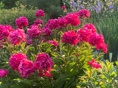
| A gorgeous Saturday evening among the peonies and irises in St. Albans, Vermont. |
If forecasts are correct, it could end up being blessedly wet.
Rainfall totals Monday through next Saturday could exceed 1.5 inches in much of the state. That is, if nothing goes wrong with the forecast.
Droughts and near-droughts sort of have a habit of being self-sustaining, so in the back of my head, I worry that the expected rain might not pan out.
That's not really a scientific statement, more of a gut feeling, if you will.
Before we get into that, I want to give a shout out to the perfect June weather in northwestern Vermont last evening.
After a day that started out dark and drizzly, then became unsettled with sun, clouds and scattered showers, the late afternoon and evening ended up being quintessentially superb June.
The sun was out, the temperatures were perfect. Bees buzzed among the gorgeous peonies and irises and it was just such a pleasure to be out in the gardens. Saturday evening answered the question I often ask in January when it's ten below: "Why the hell do I live here?"
Last evening is why.
LOOKING AHEAD
Today's going to be pretty nice, too. We'll see a fair amount of sun and comfortably warm temperatures. It could hit 80 in the very warmest spots. There could be a bit of haze in the sky from the ever-present wildfire smoke, but any smoke will be high aloft and pretty thin. Especially compared to last week.
That's not to say today will have no blemishes. There's a low risk of an isolated pop up shower or two. Already, as of 8:30 this morning, a little batch of showers was zipping through the Adirondacks, and could bring some brief light rain to central Vermont later this morning.
Monday:
Forecasters are backing off on the speed of the next oncoming batch of storminess, which, like the thing last week, is destined to stall pretty much overhead during the rest off the week.
Fun fact: Last week's stalled system was cold, and produced snow atop Mount Washington, New Hampshire for seven days in a row. The total snowfall up there was 8.4 inches, making it the snowiest June on record at New England's highest peak.
In any event, since the next thing is slower, we might eke out a decent day on Monday. Clouds will probably increase, but we could make it into the low 80s before the sun gets blotted out of the sky by the clouds - not smoke - toward the end of the day.
Tuesday:
Monday night and Tuesday morning offers our best chance of a soaker. The storm's initial weather front is at least at the moment forecast to be pretty wet. If this pans out, Vermont could see a widespread half inch to an inch of rain between midnight Monday night and early afternoon Tuesday. This would be cool beans to say the least, as the rain from last week's system was just kind of meh.
Some sun might break out, especially west of the Green Mountains Tuesday afternoon, but there will be some lingering showers.
Wednesday-Friday
The storm, in the form of an upper level pool of cool air will then stall nearby. It'll be a rehash of last week. Except it will be slightly warmer and hopefully slightly wetter than last week.
It looks like showers and a few thunderstorms will blossom each day, peaking in the afternoon and evening. From this vantage point, the showers look like they might be pretty numerous, especially on Wednesday and Friday, but we'll see.
Rainfall Tuesday night through Friday has the potential to add another half inch or more of rain to the week's total. Though it will be variable. Some places will get cheated out of many of the showers, while other places get bullseyed repeatedly. I can't say who will be the winners and losers, it will just be the luck of the draw.
If there's thunderstorms, they're unlikely to be severe, though there might end up being isolated instances of hail or gusty winds.
Although it will be a bit warmer than last week, it will still be cool for the season, with daily highs between 65 and 72. It should be well up into the 70s, to locally near 80 this time of year.

No comments:
Post a Comment