Showing posts with label snow cover. Show all posts

Wednesday, January 28, 2026

Long Lasting Cold Entrenched Here In Vermont: Nor'easter Threatens Eastern U.S.

A clear, cold, snow covered morning around my place
in St. Albans, Vermont today. Expect the cold weather
to last a long, long time. 
The cold weather continues, and so does either cursing at, or embracing the relatively deep cover of snow we have out there. 

We're stuck with the cold for quite awhile yet. In fact, toward the end of the week, the chill here in Vermont will deepen further. 

Prospects for more snow in Vermont are pretty low. We'll have the risk of snow showers and flurries from time to time this week, but accumulations should be an inch or less statewide between now and Saturday. 

Everybody's talking about a nor'easter coming up this weekend.  I'm now almost 100 percent sure that nor'easter will happen.  I'm not entirely sure on its exact path or strength yet but it really looks like we in Vermont will just be bystanders as the storm roars on by to our east.  

COLD WEATHER 

First, we'll get into the frosty mid-winter weather that has settled in. The temperature fell below 20 degrees last Friday afternoon in Burlington. 

The temperature in Burlington is not forecast to rise to 20 degrees again until maybe next Monday, which is Groundhog Day. If this forecast holds, it will be the most consecutive days Burlington has remained below 20 degrees since January, 2005, when Burlington spend 12 consecutive days under 20.

At least our current cold wave isn't as intense as the one in 2005. Back then, Burlington ended up with eight days where overnight lows were in the minus teens.   

This go around, if it does get to the minus teens in Burlington, it'll probably be only one night, either Friday or Saturday. Even that is iffy, as forecasts so far have the Champlain Valley in the single digits below zero.  However, people away from the banana belt Champlain Valley have a good shot at seeing readings in the teens below zero again later this week.  

A reinforcing shot of Arctic air will be responsible for the even colder air late this week.  Many of its will not even get past 10 above for highs Friday afternoon.

This core of this renewed shot of horribly cold air will pass by just to our west and head due south to about Tennessee, give or take, by Saturday.  That blob of frigid air will probably bring record cold air to the Southeast. More importantly, the frigid air - basically a broken off piece of the famed polar vortex - is a key ingredient that will create that nor'reaster

It'll be a so-called bomb cyclone, one that intensifies super fast.  Many meteorologists think this storm  might explode into existence near the North Carolina coast.  As it looks now, it could easily create a rare blizzard on North Carolina's Outer Banks and other spots in eastern North Carolina and Virginia Saturday night. 

If forecasts for the nor'easter turn out to be accurate, the nor'easter could blast Cape Cod and the islands Sunday before moving on to hammer Nova Scotia. 

The storm we had the other day passed far to our south, yet many Vermont towns saw a foot to a foot and a half of snow. That storm was fairly weak. but it had a lot of moisture to work with. The air flow with it enabled that moisture to go as far north as Montreal, dumping plenty of snow along the way. 

Big nor'easters like the one coming tend to hold their rain and snow closer to the storm's center.  That means if the projected track of this nor'easter verifies, the snow will miss Vermont.  

The only way we'd get snow is if future forecasts unexpectedly take the storm much further to the north and west than we're looking at now.  We probably have to wait until during the day Thursday to have a  really great handle on the exact path this nor'easter will take. 

People in eastern New England are holding their breath for this one. They got tremendous amounts of snow Sunday and Monday, so it'll be difficult to deal with another big dump. In cities like Providence, some streets as of Tuesday hadn't been plowed yet

Providence had just under 15 inches of snow in this week's storm.  Boston had 23.2 inches, its eighth largest snowstorm on record. 

There's so much snow in coastal Marblehead, Massachusetts that they're dumping some of the plowed snow into the harbor. That's usually a no-no, but the town selectboard declared an emergency so it could be done in this extreme instance.  

So, there's a lot riding on the nor'easter. A path close to the New England coast would absolutely bury eastern parts of the region even if Vermont escapes unscathed. 

We'll keep you posted. 

Tuesday, December 16, 2025

Satellite Photo Today Shows Snow Covering Most Of Northeast

Snow covers most of the Northeast now, as today
visible satellite photo shows. Click on the photo
to make it bigger and easier to see. Unfortunately
for White Christmas lovers, a lot of the snow
cover will be wiped out before the holiday. 
 Skies cleared across almost all of the Northeast today, revealing just how extensive the snow cover is.

A storm that missed Vermont on Sunday laid down a stripe of snow from Delaware to Maine. The Northeast now has a more extensive snow cover this early in the season that it's had in a long time. 

If you click on the satellite photo in this post to make it bigger and easier to see, the snow cover extended all the way down the coast to southern Delaware. 

Sunday's storm hugged the coast, so you can see that north-central Virginia and a little piece of south-central Pennsylvania missed out on the snow. 

Further west, you can see that West Virginia is snowy white, mostly from small weather systems that moved in from the west late last week, and the remnants of lake effect snows from the Great Lakes running up against West Virginia's mountains. 

It's still early in the season so you can see that lakes aren't frozen yet. Lake Winnipesaukee in New Hampshire looks wide open. Same thing for Lake Champlain, as you can just see poking out of some cloud cover late this morning near the spot where Vermont, New York and Quebec converge.

For those of you dreaming of a White Christmas, that's a really iffy proposition for most of the Northeast except for northern New England and a lot of areas near the Great Lakes. 

A warmer weather pattern is taking shape, which will melt the snow. Aside from the wet and windy storm late this week I talked about in this morning's post, northern New England should remain mostly cold enough to get a little more snow before the Big Day  

Tuesday, March 11, 2025

Weird Vermont Temperature Contrasts A Hallmark Of Early Vermont Spring

Traffic camera image from Route 7 in Bennington Monday
shows no snow on the ground, part of the reason why
temperatures were able to rise to 56 degrees there. 
 Whether or not you had a true springlike day in Vermont Monday really depending on where you were. 

Down in places like Bennington and Brattleboro and Springfield, temperatures under sunny skies reached the mid-50s so spring was definitely in the air. 

Up by the Canadian border, not so much. Highs barely struggle into the mid 30s in some towns, and the few inches of snow that fell Sunday night didn't entirely melt. 

In between the two extremes, the north and the south, Vermont had a pleasantly enough mild March day, but it wasn't hard core spring. 

These kinds of weird temperature extremes in the Green Mountain State happen frequently in the late winter and early spring. You're going to see a little more of that today, too.

MONDAY WEIRDNESS

Part of the reason there were such temperature contrasts in Vermont came up in a post I filed last week.  . This time of year, frigid air - lingering winter - often stays firmly in place over the vast frozen forests and lakes of central and northern Quebec. 

If winds are light northerly, a thin layer of that cold air can bleed southward into far northern Vermont, so places like Highgate and Alburgh and St. Albans and Newport can occasionally get that frigid Quebecois feeling in early spring. 

That's what happened Monday. Newport only managed a high of 36 degrees Monday. 

Meanwhile, daytime temperatures, especially on sunny March afternoons, depend greatly on what's on the ground. 

Still a good amount of snow on the ground around
my house in St. Albans, Vermont Monday, part of the
reason why high temperatures never got out of
the low 40s during the afternoon.

Bare ground absorbs the sun's heat, and thus warms the air in the lowest couple thousand feet of the atmosphere. Those places would be noticeably balmier than places that are snow-covered.

There's pretty much no snow left on the ground around Bennington. So, the sun was able to heat things up nicely, which is a big part of the reason why high temperatures there on Monday was 56 degrees.  . 

Southeastern Vermont, around Brattleboro and Springfield, does still have some snow on the ground, but that snow is thin with plenty of bare spots  A northwest wind Monday also helped the air warm up. 

When the air flows down the slopes of mountains, in this case the southern Green Mountains, it compresses. Compressing air tends to warm up. Which meant the valleys of southeast Vermont also enjoyed some mid-50s  in the afternoon

Central Vermont was in a sort of unaffected middle. There's still plenty of snow on the ground in most of the area between Route 4 and Route 2. So the sun's heat reflected off the white snow cover. Which means it couldn't get quite as warm as it would have with bare ground. Also, some of the sun's energy went into trying to melt some of the snow rather than heat the atmosphere. 

However, that cold air from Quebec wasn't able to bleed southward all that much, so none of that Canadian chill could make it as far south as Route 2.  

The end result was a happy medium with highs well into the 40s. Montpelier had a high temperature of 46 degrees Monday. It probably resulted in a decent sap run in the sugar bushes, so we can't complain about that. 

TODAY

Strong south to southwest winds will briefly bring temperatures well up into the 50s to near 60 statewide.

An exception to the warmth will be right along the shores of Lake Champlain. Those southwest winds will pick up the chill from the icy waters of the lake and blow it ashore Places like Burlington's Waterfront Park will be stuck in the 40s at best for most of the day. Meanwhile, communities a few miles inland from Lake Champlain will be flirting with 60 degrees this afternoon.  

These lake breezes will often keep the immediate shore of Lake Champlain cooler than other areas well into early summer at least. 

Large scale storm systems are still strong this time of year too, so those bring sharp changes in temperature. 

A cold front will turn our balmy Tuesday of near 60 degree weather to a subfreezing shiver fest for Wednesday afternoon. Then, we're still expecting that massive storm in the Midwest to pump us right back up into the 60s again this weekend.

Those are the typical wild temperature gyrations we expect out of a March and April in Vermont.   As always, expect a wild ride and some surprises as we move through the first part of spring. 

Wednesday, March 13, 2024

Vermont Spring Weather Bursts Forth Again, At Least For Now

Deep blue skies and fresh white snow cover in
Bakersfield, Vermont Tuesday on a spectacularly
bright and gorgeous March day. 
 Wasn't Tuesday's weather absolutely spectacular?   

The sky was the deepest blue imaginable. In places that received a lot of snow earlier this week the white gleamed in the bright, high angle sunshine of March.  

Near Lake Champlain, the lack of snow cover really helped the day warm up.

Everywhere, the combination of the subfreezing weather Sunday and Monday and the warm sunshine of Tuesday had sugar makers super busy, which is a good sign.  

I noticed a couple of interesting things going on yesterday. Satellite photos showed thick snow cover in most of Vermont. The immediate Champlain Valley, places right along the Connecticut River and in some low lands in southwestern Vermont the ground was free of snow.

The satellite picture exactly matched the National Weather Service map of actual snow totals.  Only a couple inches fell in low spots, which quickly melted. Up to a foot and a half fell along the west slopes of the Greens.

Satellite photo with clear skies Tuesday shows 
snow cover in the Adirondacks, most of 
Vermont outside the warmer valleys and
in western New Hampshire. 
The snow cover, or lack of it had a noticeable effect on daytime temperatures Tuesday.

 In areas with no snow, the bare ground absorbed the bright sun's heat and temperatures soared into the low 50s. 

In other areas, the fresh snow cover bounced the sun's heat back out to space to some extent, so temperatures there held mostly around 40 degrees. 

It just demonstrate to show that if you have an early spring with little snow on the ground, chances are you also have a rather warm early spring. Which is what we've had so far. 

That state of affairs should continue into the weekend, even in areas that have a snow cover. Which will be waning anyway.

Outlook

We had another freeze last night, so that should again help those out there sugaring. However, many of us will once again stay above freezing from now until at least Sunday night.  

Those long stretches of warm nights we have had have all winter and early spring have interfered with sugaring and the winter sports industry. Plus has created our never ending mud season, which essentially started in January. 

High temperatures will reach to within a few degrees either side of 50 degrees today and tomorrow, which is definitely on the mild side for mid-March. Even this weekend, highs will "only" be in the mid and upper 40s, which is still a bit on the balmy side for the period around St. Patrick's Day. 

National Weather Service map of snow totals from
the storm we just had matches the satellite photo 
above. Where little snow fell, the ground is
already bare. Where it was heavy, the ground gleams
white with snow, at least for now. 
Tuesday would have been a great day for a solar eclipse, but alas, we'll have to pray for similar weather on April 8, when the actual eclipse gets here.

The blue skies of Tuesday are gone, in favor of a mix of clouds and sun. More rain is in the forecast, so that will worsen our long slog through mud season.

In Burlington, it's not even quite mid month and we've already had very close to what is normal precipitation for the entire month. The upcoming rains won't be especially heavy.

With snow melt and the lighter rains rivers and streams will probably get high or stay that way, but we won't have enough rain to create huge flood problems.. Just more mud.

The best chances of rain are Thursday night and Friday, and again probably on Sunday.  We'll probably see a couple days of pretty chilly weather starting Monday, as it looks now. 

Laughable Computer Model

The following will almost certainly not happen, but it's an illustration of how I am sometimes entertained by long range forecasts. It's especially a cautionary tale as to why you should't believe weather forecasts beyond, say, five days out. 

The American computer model depicts a mega-storm affecting the Northeast, including Vermont around March 26. But the model's evolution of the proposed storm makes absolutely no sense.  It also has the storm going by far to the south of Vermont, but still somehow flinging three or four  inches of rain our way. 

By Wednesday the 27th, it has the storm something like 400 or 500 miles of the New England coast and still giving Vermont heavy precipitation.  Yeah, right.

I suppose there might be some sort of storminess toward the end of March, and these long range forecasts are sort OK for giving a hint at future weather patterns. But the specifics? Hah!  That American computer model was drinking way too much vodka when it came up with the storm forecast for March 26-27.

It ain't going to happen. 


Thursday, January 18, 2024

After Vermont Storms, Chances Of Renewed Flooding Not Worrisome. At Least For Now

Flooding in Winooski, Vermont on December 19, 2023,
The National Weather Service in South Burlington releases
bi-weekly flood outlooks in the winter and early spring. Today's
updated outlook offer not much to worry about. 
 Those bi-weekly flood outlooks the National Weather Service office in South Burlington puts out every other Thursday take on an added importance after all the extreme weather we'v'e had.  

I think a lot of us Vermonters are still feeling pretty raw after the epic floods last summer and the renewed, destructive floods in December. 

The latest flood outlook came out today and continues to show near normal flood potential for the next two weeks. That really means that we won't have any flooding, unless an unusually heavy rain storm wanders through. 

These bi-weekly flood outlooks take into consideration snowpack, soil moisture, water levels and weather forecasts. 

Opposing factors - some that enhance flood potential, others that diminish the chances - are competing against each other. 

We've had a wicked stormy weather pattern for weeks, months, really. So the ground is saturated, and stream flows are running a little high. 

But it's also been warm. That means there's not much river ice that could eventually cause ice jams.  Mountain snow cover and the amount of water in that snow is below normal.  Which reduces the chances that a lot of melting snow would add to runoff if we had a big rain storm. 

It's going to be cold the next few days, which means river ice will increase. But not all that much, because the cold weather doesn't look like it will last long. The deepest cold should just run from today through Sunday before an another warmup starts. 

We've also started a rather dry weather pattern yesterday, but forecasters think it will start to get a little wetter next week. Light snows are hitting some northern areas today, and more very light snow might fall Saturday. But that will add very little to the snow cover and potential runoff in the mountains. 

However, that warmer weather pattern expected to begin next week will be fairly active once again.  That means frequent chances of precipitation. The good news is at this point at least, I don't see signs of any kind of mega-storm sweeping through Vermont. So that will be a welcome break. 

There is, however, an elevated chance of flooding in southeastern New England, mostly because they have been even wetter than Vermont has over the past couple of weeks. 

There's also a somewhat higher than average chance of flooding out by Buffalo, New York and surrounding areas. They've been getting buried in lake effect snow this week. When it warms up, rain and thawing could produce flooding out there.  

Tuesday, January 9, 2024

First Of Vermont Spring Flood Outlooks Issued; This Early In Season, Really Too Early To Tell

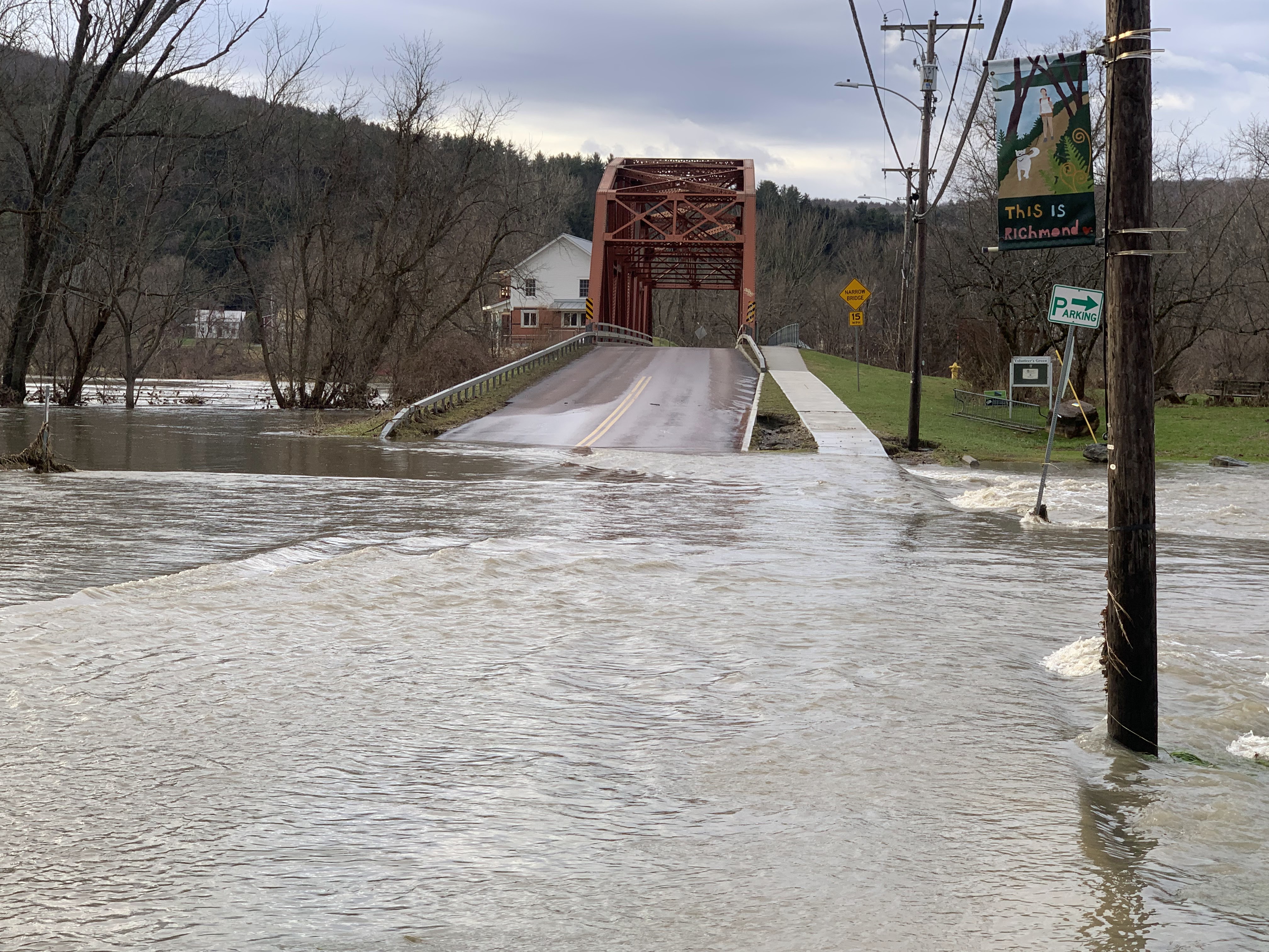
Flooding in Richmond, Vermont, December 19, 2023,
Heavy rain and warm temperatures in December made
groundwater sopping wet, but got rid of most of
Vermont's mountain snow cover. As things stand now
that leaves this spring's flood potential as "normal"
But a LOT can happen to change that one way
or another by March and April 
 Every year, starting in early January, the National Weather Service office in South Burlington, and other NWS offices, start to issue spring flood outlooks. 

Yeah, it's a little early to worry about spring floods, but I guess these early outlooks give us a baseline to start following trends.  

A lot can happen between now and spring to affect our chances of yet another unwelcome inundation around Vermont when it warms up in a few months. But it's OK to keep tabs.

For the record, the outlook issued last Thursday for spring flooding works out to normal, all things considered. As you are probably well aware, December in Vermont was sopping wet, so groundwater is definitely above average.

However, snow cover was far below average when the flood forecast was issued last week, so there's not a lot of moisture built up in the mountains to unleash as floodwater when temperatures rise in March and April.

That's one of the big wild cards, though. We know snow cover will increase this month from the paltry levels we saw last week.  Snow cover has already gone up in the past week, and might tonight. But it's still well below normal.   However, if the rest of the winter proves snowy, which is actually possible, that would change the outlook. 

Longer range forecasts indicate that starting about next Sunday, a new somewhat colder, and maybe (or maybe not!) somewhat drier weather pattern will take hold. I don't know if that will last all winter, or just be a brief blip, or something in between.  If it does hold for the rest of the winter, chances are snow cover will finally build up in the mountains. 

Which is one of the many reasons forecasting spring flooding is difficult to say the least in early January. 

Ice jams are a big hazard with spring floods in Vermont. River ice can get pretty thick during colder winters,  If a thaw breaks up that ice, those big chunks of ice can get stuck at barriers like bridges, creating a dam that results in a nasty upstream flood.

After the flooding and extraordinary warmth of December, there's almost no ice on Vermont rivers. So there's obviously no immediate threat of ice jams.

River ice will form as we get through January, but we don't know how thick it will get. Depends upon how cold it gets. The thicker the river ice, the greater the chances of ice jams that hold in place. Thinner ice breaks up into more small, slushy chunks that doesn't jam up so easily. 

In the immediate future, over the next week or so,  it's generally expected to be warmer and wetter than normal in Vermont.  As mentioned this morning, there is some threat of flooding with our storm tonight and tomorrow, but mostly in far southern Vermont. 

It's too soon to say whether the large storm expected Saturday will be warm and wet enough to create a flood threat. After that, as mentioned,  a cooler, somewhat drier trend is expected to take over. 

Another interesting wildcard is the Lake Champlain water level. It's much above normal for this time of year - only about half a foot below record highs for January. It has started to recede a bit from its late December peak though.  

The lake level will probably take another bump upward after the storm tonight and tomorrow, and another one expected on Saturday. After that, the lake will probably slowly recede during the rest of January and February,  unless it stays oddly warm and rainy.   ss it's especially warm and rainy. 

Still, if lake levels are still above normal in the spring, and there's a lot of snow that somehow accumulates in the mountains by then, we could have some real problems along the shores of Lake Champlain.  Especially if it's also a rainy spring. 

At this point, I'd say the risk is still low, but you never know.