Monday, November 9, 2020

More Record Vermont Warmth, Hot Year, And Eta Trouble

Another record warm, sunny November day is dawning in
the Northeast, so we've put our palm tree back out on
our weather deck in St. Albans, Vermont 
 More record highs are falling around Vermont and elsewhere as a strong November heat wave continues.  

Among the record highs were 70 degrees in Montpelier, 69 degrees in St. Johnsbury and 72 degrees in Springfield

No fewer than 46 record highs were reported in the eastern United States Sunday. More records are sure to fall today and tomorrow.

Burlington, Vermont fell short of a record high Sunday. It "only" got to 72 degrees, just shy of the record 74 degrees set in 1996.

Today, Burlington has a better shot at a record high.  The record high for today is 68 degrees and the forecast high is 70. 

This is quite a contrast to last year, when winter hit early and hard.  Exactly one year before Burlington had that 72 degrees, the high temperature on November 8, 2019 was just 30 degrees. And there was 2.6 of snow that day.  

We ain't getting any snow for a few days at least, folks. 

We've had a lot of warm weather this year in Vermont, no doubt.  We could easily have one of our top 10 warmest years on record. 

I added up all the temperature records so far this year, then assumed temperatures in November and December would come out just exactly at average.  That would make this year the fourth warmest on record in Burlington, with a mean temperature of 48.5 degrees.

The warmest year on record was 2012, with a mean temperature of 49.2 degrees.

We could even move up in my projected rankings.  It's really beginning to look like this November will come out warmer than normal.  But of course who knows what December will bring.

I'm beginning to sound like Steve Kornacki at the NBC Big Board on election week, so I"ll stop with this for now. 

TROPICAL STORM ETA UPDATE

We had yet another landfalling tropical storm in the United States last night as Tropical Storm Eta moved over the Florida Keys. 

It was the 12th tropical storm or hurricane to strike the United States this year. The previous record for most tropical storms to hit the U.S. was nine, back in 1916.

Storm surge flooding and high winds hit the Keys, but it seems the worst effects of Eta so far are in South Florida, especially in and around Miami and Fort Lauderdale. 

Feeder bands of torrential rains keep swirling into South Florida and were continuing to do so early Monday morning.  Many roads and streets there are under water and impassable.

Tropical Storm Eta might strengthen into a hurricane for a time in the eastern Gulf of Mexico over the next day or two.  It looks like it's going to meander aimlessly out there much of this week, then maybe head back toward northern Florida.  That forecast is still on the uncertain side, though. 


Sunday, November 8, 2020

Tropical Storm Eta And This And That

Forecast tracks for Eta have in meandering around the
eastern Gulf of Mexico and harassing Florida for the 
rest of the week.
Tropical Storm Eta, - I've been calling it Zombie Eta after it came back to life near Honduras this past week - was making landfall in Cuba this morning with top winds of 65 mph or so. 

It's still expected to dump a LOT of rain on South Florida as it drifts over the Florida Keys by early Monday morning. So, yep! The United States gets to experience yet another tropical storm at the tail end of this busy hurricane season. 

Eta might actually achieve hurricane status with sustained winds of 74 mph or more.  The Florida Keys can expect winds at least gusting to hurricane force and some dangerous storm surge flooding in these low lying islands.

For good reason South Florida is under a tropical storm warning and hurricane watch for tonight and early Monday. 

From there, Eta is forecast to drift pretty aimlessly in the eastern Gulf of Mexico for the rest of the week, creating a continued threat for the western coast of the Florida peninsula.  On the bright side, there's hope that Eta will gradually weaken out there in the Gulf, done in perhaps by strong upper level winds and dry air getting sucked into the system.

Of course, there's no guarantee Eta will weaken  like that.  Some forecast models keep it as a hurricane in the eastern Gulf of Mexico this week. 

As we well know,  tropical storms are often unpredictable, and the way this year has gone, anything can happen, right?

BLUE SKY HISTORY

I think everybody knows by now that history was made Saturday as Joe Biden was declared, at least by all the major media outlets, as the victor in this year's presidential election.

This prompted an outpouring of happy partying in numerous cities across the United States 

I was struck by the blue skies and warm temperatures that coincided with this  Two of the most historic days in my memory were like this.

People remember the dark day of 9/11 also hit on a gloriously blue sky day.  People still remember that sky.  Things were similar Saturday, but this time it was totally joyous. Though of course I do have to acknowledge the disappointment among Trump fans. 

However, history will most likely focus on the beyond-happy outbursts in many cities in the United States under those clear blue skies. Including here in Vermont. 

 RECORD HIGHS IN REGION

As expected, temperatures in and near Vermont are getting into record territory. In Montpelier, it reached 71 degrees Saturday, breaking the old record high for the date if 69 degrees, set during a similar long lasting November heat wave in 1975.

Plattsburgh, New York soared to 75 degrees, besting the old record of 71 degrees in 1948.

Forecasts continue to indicate more record highs will be set around here today, tomorrow and Tuesday.  

Saturday, November 7, 2020

Vermont November Warm Spell To Be Among Strongest, Longest On Record

Warm winds blowing over the Adirondacks this week
helped create these sculpted clouds over South Burlington,
Vermont. Warm, dry weather is forecast to 
continue through Tuesday. 
 Last evening here in St. Albans, Vermont, armed with a head lamp due to the early sunsets this time of year, I went out into my property to do more autumn clean up.  

At 7 p.m., I'm out there in a t-shirt, and even with that on and no jacket, I worked up quite a sweat.  It was so warm and balmy we would have loved to have dinner out on the deck had we not already put away the outdoor furniture for the winter.

Pretty remarkable. And I'm loving it. 

This is very pleasant, to say the least, and it's going to go on for awhile yet.  

I checked back on past records from Burlington, Vermont, and this will be among the warmest and longest stretches of November Indian Summer in the books. 

We probably won't reach the all time high for the month of November, which was 75 degrees, last set in 1950. But it could come close and some daily high temperature records might be threatened between now and next Wednesday. 

For comparisons sake, here are the daily high temperatures in Burlington for the warmest November stretches I could find:

November 4-8, 1938: 62, 72, 66, 74, 70.

November 4-10 1948: 60, 68, 75, 58, 56, 58, 74

November 2-10, 1975: 62, 66, 64, 58, 59, 68, 71, 64, 64.

Now, let's compare that to the actual so far, and forecast highs in Burlington for:

November 5-11, 2020: 67, 69, 70, 68, 70, 70, 66

So yeah, this will easily be a top 5 most intense November "heat wave."

You don't need to prematurely more the loss of the upcoming winter. It can and indeed has gotten pretty cold after the past November warm spells.  In 1938, it was below zero by the 25th and 26th. The winter that followed the 1975 November warmth was quite cold and snowy. 

I can't tell what will happen after the end of the month.  At this point, it looks like it will turn somewhat cooler starting next Thursday, but there are few signs of very cold, wintry weather later in the month. Long range forecasts call for generally warmer than normal temperatures around here through around November 20.

This warm spell is also accompanied by a lack of rain, which is bad because there's a lingering drought and dry conditions in Vermont. We could have used a wet November.  It does appear things will get somewhat wetter starting the middle of next week, but it remains to be seen how much rain we actually get. 

At least it's not as bad as the Midwest. They've also had a record warm temperatures and very dry conditions so far this month.  Wildfires actually broke out yesterday in Minnesota and South Dakota, which is very odd in November for that part of the nation 

It is expected to rain and turn cooler out there over the next couple of days.


Friday, November 6, 2020

Forecasters Were Right About Zombie Eta

Once-Hurricane Eta is expected to be reborn and 
possibly become a tropical storm threat in South
Florida and perhaps the Gulf Coast states.
Hurricane Eta, as we well know, unleashed some terrible flooding on Nicaragua and Honduras this week.

The storm has killed at least 57 people in Central America, and to me it looks like unfortunately, that toll is certain to rise.  

The only "good" news is this won't be as bad as Hurricane Mitch in 1998, which is believed to have killed 11,000 people in the same region. 

There's more evidence today that Eta is not done yet. 

The center of Eta's remains poked back out into the western Caribbean Sea just off the coast of Honduras overnight.  

Thunderstorms are once again firing around the center of what is now a tropical depression.  A reborn Tropical Storm Eta now seems inevitable. Zombie Eta is about to arrive.

Eta will never again reach the intensity it had as a monster Category 4 hurricane when it hit Nicaragua a few days ago.  There's too many complicating factors, like wind shear aloft, interaction with land, and a broad circulation in Eta that will take time to get its act together. 

But Eta will be over very warm water, so it will intensify into a pretty strong tropical storm. There's even an outside chance it could become a hurricane again.  Intensity forecasts are tricky with tropical systems, and this one is no exception 

Once again in this busy Atlantic tropical storm season, the United States looks like it's in play.  Eta will head northeastward and hit Cuba toward Sunday.

From there, things might get a little weird.  A storm in the upper atmosphere in the western Gulf of Mexico seems like it wants to pull Eta north toward the southern tip of Florida, then westward into the central Gulf of Mexico. From there, who knows?

November tropical storms do have some trouble surviving north of the Caribbean, due to stronger upper level winds this time of year. But they do happen. It's still hurricane season. 

At this point, Eta looks like it will never again be a powerful wind maker.  But it certainly has a shot of unleashing some nasty floods on southern Florida, which has already had a very soggy autumn.  Stay tuned! 

Thursday, November 5, 2020

After Wintry Blast, Much Of Nation Gets Break

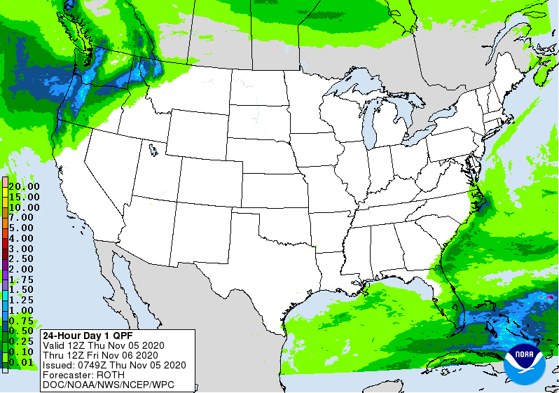
National rain forecast for today.  It's quite unusual to 
see almost all of the continental United States rain and
snow free this time of year. 
 That incredible cold wave that brought unprecedented early season low temperatures to parts of the Rockies and Plains in late October has had quite a reversal as November starts. 

Record high temperatures have hit, or are about to hit, from the Rockies to the Northeast.  

One of the biggest temperature recoveries has to be in Laramie, Wyoming.  It got down to an incredible 26 below zero there on October 27.  That was the coldest temperature on record there for both October and November. 

Just six days later, on November 2, Laramie tied a record high for the date with 66 degrees. The first seven days of November in Laramie will all be in the 60s. Normal temperatures there for this time of year are highs in the upper 40s and lows in the lower 20s).  

The northern Plains States have embraced some pretty intense warmth for November after that terrible late October winter spell. In South Dakota, where temperatures were in the single numbers in late October, readings reached record highs of near 80 degrees on Wednesday. 

Here in Vermont, the temperature swings aren't as dramatic, but we're still now firmly in a warm spell after the early week winter blast. This warmth will only intensify by the weekend, and a few spots could reach 70 degrees. That's near record territory.  That kind of warmth is very odd, but not unprecedented for mid-November.

Yesterday in Burlington, after starting out at 30 degrees, we reached 56 degrees under clear skies.  This morning, it's interesting to see what south winds can do to temperatures.  In Burlington, Vermont, where a steady south wind was blowing, it was a balmy 53 degrees at 6 a.m. this morning. That's warmer than the the normal high temperature for the date.

But east of the Green Mountains, where winds are calm and skies are clear, it cooled right down overnight.  It was just 27 degrees in Morrisville at 6 a.m.  Temperatures will even out in the low to mid 60s this afternoon.

November is usually a stormy and cloudy month for the United States but we're also getting an odd break from that right now.  The only rain in the forecast anywhere in the United States is in the Pacific Northwest and in southern Florida.  

This being November, the nation won't stay free of rain and
snow for long. This is the precipitation forecast map
for the next seven days. 

There is also very little cloudiness for this time of year in the continental United States.

This being November, the storm situation will quickly change. A revived former Hurricane Eta might affect Florida as a tropical storm this weekend. 

Also, a strong storm is forecast to affect the Pacific Northwest and northern Rockies by the weekend. The stormy weather will then head east across the nation.

Some rain is expected to spread through most of California within the next seven days. That's the first wet weather most of the state will have had since last spring.  

They're getting into the autumn and winter rainy season.  With all the wildfires this year in California, I'm sure everybody there will be grateful for the wet weather. 

Here in Vermont, we don't expect any precipitation until Tuesday at the earliest. That's a remarkably long stretch of dry weather for November.  There's usually some rain or snow pretty much every other day at least around here this time of year. 

So enjoy this long stretch of mild, possibly record warm weather now through Tuesday. It will be the last time you experience such a nice stretch of weather in the Green Mountain State until next spring. 

Wednesday, November 4, 2020

Hurricane Eta: Zombie Version In U.S.? Meanwhile More On Incoming Vermont Warmth

Evacuations in Nicaragua due to Hurricane Eta. Photo
via BBC
Hurricane Eta lurked just offshore around Nicaragua for much of the early part of Tuesday, smashing the nation with destructive winds and torrential rains causing intense rains. 

Eta then moved inland and its winds are rapidly diminishing as Central American mountains destroy the now former hurricane's circulation.  

But those torrential rains are continuing, and I definitely fear for what people are going through in Nicaragua and Honduras with the flooding. 

It will take awhile - perhaps days -  for the news of exactly what is happening in the disaster zone, but what we find out will surely be grim. There is no doubt epic flash flooding and mudslides going on.  The destructive winds that hit the coast of Nicaragua will almost be an afterthought compared to this. 

So, we'll keep an eye on this. 

Plus, we have to keep an eye on the actual storm.   Usually, when a hurricane plows into Central America, it dies a quick death in the mountains and that's that.   Every once in a while, some remains of such a storm emerge into the Pacific Ocean to create a new tropical storm or hurricane. 

Or, somewhat more rarely and occasionally, the pitiful remains of a Central American hurricane somehow get kicked back out to the western Caribbean Sea or southern Gulf of Mexico to create more mischief. 

That appears to be what will likely happen with former Hurricane Eta.  As the National Hurricane Center forecasts, the low level circulation of Eta should be destroyed within a day or two.  But its upper level spin is forecast to come back out into the far western Caribbean Sea around Friday.

This will create what I might call a zombie version of Eta.  The NHC thinks it will redevelop into a tropical storm and become a possible threat to Cuba and Florida.

Nobody thinks Zombie Eta will become an extreme  Category 4 hurricane as it was when it tortured Nicaragua this week.  

But this is 2020, so if anything can go wrong, it will.  Which makes me say "go figure" with the forecast for Zombie Eta. I imagine if a revived Eta affects Florida early next week, its primary threat would be heavy rains.  

South Florida had a sopping wet October, so they're especially flood prone right now.  If Eta arrives, that could trigger some serious flooding.  That's not an official forecast, at least not yet, but it's something to keep an eye on.

VERMONT WARMTH

As promised for days now, we're about to enter an odd (for November) warm spell.  Odd mostly because of how long it's expected to last. 

You'll notice the increasing warmth today, but it won't really hit until tomorrow.  If you have a little snow on the ground, it will be gone by sunset today.  If you have a lot of snow on the ground - I'm talking to you western slopes of the Green Mountains boys and girls - it might take a couple or few days, but it will go.

Today, high temperatures will be in the 40s to near 50 in the warm spots, especially south and west of Interstate 89.  Then we get a spell starting tomorrow and lasting through at least Tuesday in which afternoon highs in Vermont reach the 60s in many areas. (Friday might be briefly a little cooler, but not by much). 

Another oddity will be the lack of precipitation.  It's possible a couple of weak, stalled out fronts north of us could spread a few sprinkles our way. But don't expect anything major until at least Tuesday.

Also, there will be at least some sunshine almost every day through Tuesday.  It probably won't be crystal clear most of the time. However, such a long stretch of days with at least a chance of seeing some some in November is rare.  This is normally the gloomiest month of the year. 

There's still a chance some record highs might fall.  There was a smattering of record highs in the Midwest and northern Plains yesterday, and that state of affairs looks like it wants to spread this way by the weekend. 

For those of you who prefer winter, relax.  It's only November. You have plenty of time coming up to enjoy the snow.

Tuesday, November 3, 2020

Vote Today In Good Weather; Vermont Snow; Horrible Hurricane Eta

You can't use weather as an excuse not to vote.
Weather across the nation is very quiet today. If you
haven't already voted, go out and do it! 
 It's voting day in America. If you haven't voted yet, get your butt out there and do it! We always say it's important, and it is. Especially this year, though. 

I don't want to hear any weather excuses for not voting either.  Yes, here in Vermont, we have some of the "worst" weather in the United States right now. 

That's not saying much. Sure it snowed last night (more on that in a bit), and it's chilly out there, but the roads have pretty much cleared out and you're a wimp if you can't bear to get out and do your civic duty just because it's slightly nippy.

Nationwide, you can't ask for better voting weather.  The extremes of last week are gone, and the weather for most of the United States today is gloriously boring. 

There are no big storms.  Temperatures in most places are moderate. The only weather I'm seeing anywhere is rainy conditions in the Pacific Northwest.  Yeah, breaking news. Rain in Seattle. They can deal with it. 

An air quality advisory is still up in central California and strong winds are possible in northern Montana. That's it.  Extremely quiet weather for November in the United States.

Go. Vote. Now. 

VERMONT SNOW

It's a bit of a winter wonderland out side my St. Albans, Vermont house this morning. We had a blizzardish spell last night, and now the ground is covered by two inches of snow.  Nothing extreme for early November, really, but it's a reminder that winter is on its way. 

Two inches of snow on my deck in St. Albans, Vermont this
morning.  Up to a foot of new snow was reported in 
the Green Mountains. 

As expected, there were some impressive snow totals near the western slopes of the Green Mountains.  

A solid foot of snow accumulated at a 1,200 foot elevation near Moretown. At an elevation of 1,550 feet a spot near Smuggler's Notch was buried in 11 inches of new powder.  Stowe had 10 inches. Morrisville reported eight inches. East Enosburg clocked in at 7.5 inches. Hyde Park had seven inches. Calais and Woodbury reported six inches. 

It's basically over, aside from a few lingering snow showers.  A strong November Indian Summer is still on its way, so we'll have several days of warm, dry weather Thursday through the weekend. (Tomorrow will be a transition day: A cold start with a mild, thawing afternoon).  By the weekend, we can expect near record highs in the 60s to near 70. 

Winter hasn't fully grasped us yet.

HORRIBLE HURRICANE ETA

Now we have some terrible weather news: 

Extremely powerful Hurricane Eta was about to make landfall in Nicaragua as of this mid-morning writing.  Eta blew up explosively Monday to become a borderline Category 4/5 storm.  As of mid-morning, Hurricane Eta had top sustained winds of 145 mph. 

This means it's the most powerful hurricane of the 2020 season.  One remarkable thing is how late in the season this is happening.  Late season tropical storms tend to be somewhat weaker and short-lived than those at the peak of the season.  

It turns out Hurricane Eta is the third strongest November hurricane on record for the Atlantic basin. 

Hurricane Eta is also moving very slowly. Which means that on top of the devastating winds and catastrophic storm surges, the flash flooding from two to three feet of rain in mountainous Nicaragua and Honduras are going to be extreme and highly deadly. 

There will be a lot of bad news coming out of Nicaragua and Honduras over the next few days.