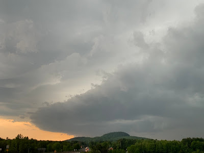
As expected, a few strong thunderstorms, and a couple severe ones afflicted parts of Vermont Tuesday.
 |
| Great structure on a strong, but not severe storm approaching Georgia, Vermont Tuesday evening. |
One storm was still probably marginally severe after knocking down trees in Washington County, New York, just over the Rutland and Bennington county Vermont borders. It tracked across south central Vermont and eventually caused more tree damage in southwestern New Hampshire.
But the true big storm was the supercell-like thing that popped up abruptly near the northern tip of Lake Champlain and trekked east, just south of the International border through Highgate and into Enosburg and probably beyond.
This one was intense. Route 207 was blocked for a time by fallen trees and branches. Social media showed West Enosburg Road in West Enosburg blocked by downed trees, power poles and power lines. Intense hail covered the ground around Enosburg. Some of the hailstones were the size of a quarter, so that had to hurt.
As expected, the storms settled down after sunset, which leads us to another interesting Vermont weather day, at least in a few spots
TODAY
This will be the hottest day of this warm spell. Most - but definitely not all of us - will be storm free. But hot and humid. Expect readings well into the 80s with a few banana belt towns maybe touching 90.
Even though temperatures should fall just barely short of record highs, we're hot used to this type of weather so early in the season.
 |
| Another view of the storm in Georgia, Vermont Tuesday. |
As a sort of besides side note, the record high of 93 degrees in Burlington today, set in 1977, was a dry heat, not the humid sort of stuff we have today. That day in 1977 had also been the hottest May temperature on record until May 27, 2020, when it got to 95.
Anyway, today will be hot. Take it easy.
There's no major weather disturbances to set off any storms today, so we'll rely on local effects. Updrafts near the mountains will probably cause a few popups.
The wild card is near Lake Champlain.
The cool waters set off lake breezes, which punch batches of relatively cool air just inland, right near the shore. These lake breezes act like mini cold fronts bopping into the hot, humid air. This contrast initiates updrafts which can turn into thunderstorms pretty quickly.
The lake breezes would probably be sharper than they would be later in the season. The overall air mass is something we'd normally expect in July. So the contrast is greater, which makes things all the more dynamic.
Hot humid air often just needs some sort of spark to trigger strong storms. The lake breezes just might be the spark. So boaters and beach goers should be on the look out for rapidly forming storms this afternoon which could cause strong, gusty winds, dangerous lightning and torrential downpours.
TONIGHT/TOMORROW
Almost always when a hot, humid spell gets ready to end, it comes in the form of a cold front. More often than not, there's a disturbance ahead of the cold front, naturally called a pre-frontal trough that is often the focus of thunderstorms.
If that pre-frontal trough comes through during peak heating in the afternoon or evening, you get severe storms. Those are less likely at night. Luckily, our first big pre-frontal trough comes through tonight. That just means a smattering of showers and storms on a muggy overnight that we're expecting.
The actual cold front comes through tomorrow. As it looks now we'll see it too early in the day for the front to take advantage of the sun's heat to fire up another round of strong storms. If there's any severe storms Thursday, they're most likely in eastern New England, where the cold front will arrive later.
As the day goes on, especially in the late afternoon and evening, you'll really notice a change in the air. Refreshing breezes will really drop the humidity, and our first round of oppressive summer air of the season will be over.

No comments:
Post a Comment