 |
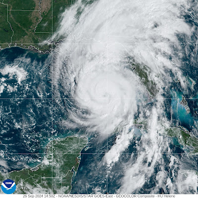
| Satellite view of Hurricane Helene shortly before noon today |
Highest sustained winds have steadily increased from 90 mph at 4 a.m to 105 mph as of 11 a.m. We know Hurricane Helene will keep strengthening until landfall, but by how much?
The signs remain ominous. Satellite photos of the storm late this morning show it looking more symmetrical and circular than it did earlier today.
Increasingly intense thunderstorms are getting better at wrapping fully around Helene's eye. The storm is about to move over the most favorable spot for strengthening on its path to the coast.
At this point, it doesn't matter a whole lot whether Hurricane Helene is a Category 3 (sustained winds of 111 to 129 mph) or a Category 4 (winds at 130 to 156 mph) at landfall.
STORM SURGE
It's such a large storm that its biggest weapon through landfall is storm surge. This hurricane is covering a bigger area in the Gulf of Mexico than almost any storm there in history. That'll enable it to grab a lot of ocean water and push it onshore.
That's why forecasters and are so worried that the storm surge in and near Florida's Big Bend area.
Storm surges were already starting to affect the western coast of Florida by late morning. Worsening storm surges have been reported in Key West and Sarasota and near Tampa. Ocean water was also beginning to rise in the expected landfall zone as of late morning.
Gov. Ron DeSantis this morning issued a last ditch plea for those who have not evacuated from the expected worst storm surge zone northwest Florida to do so now if not sooner, so to speak. There was still a short window of opportunity to flee ahead of what keeps being described as an "unsurvivable" storm surge.
DeSantis and others advised people not to flee north to Georgia, which will have its own problems with destructive winds and severe flooding. Probably the best bet would be to head west toward Mississippi and Alabama, where the effects of the storm shouldn't be nearly as severe.
WIND
So far tropical storm force winds have already started raking western Florida. Some outer rain bands have produced gusts to at least 50 mph. This is just a tiny foretaste of what's to come.
As we mentioned yesterday, Helene's size and fast forward pace will ensure high winds cover an enormous amount of real estate.
Near where Helene comes ashore, many homes and businesses will have their roofs blown off. Exterior walls could collapse under the weight of the wind, too.
The winds dozens and hundreds of miles inland might not be catastrophic as what will happen along the coast. But the giant and highly populated parts of the Southeast will see widespread tree and power line damage. Plus a lot of houses and other buildings will suffer serious damage from trees falling on them.
Winds in the rather forested Atlanta metro region and Asheville, North Carolina could gust to 65 mph. Gusts will probably reach hurricane force in the higher elevations often southern Appalachians
Wind advisories are in effect for places as far inland from the Gulf of Mexico as southern Indiana, where gusts could reach 55 mph on Friday.
Power repair crews from across the nation are staging in and near the storm zone, ready to start getting the lights back on after the storm. But the process in many areas could take weeks.
EXTREME FLOODING
Destructive inland flooding almost always happens after a hurricane makes landfall. But the flooding in this case looks like it will be much, much worse than usual.
The downpours that started in the southern Appalachians yesterday due to a "predecessor rain event" has already caused one in 100 year type flooding in western North Carolina, the mountains of South Carolina and eastern Tennessee.
Asheville, North Carolina has already had more than seven inches of rain since Wednesday morning, and that total could easily double by the time the storm is done.
Some areas in the southern Appalachians have already received up to ten inches of rain, and another incredible 15 to 20 inches could fall in some spots.
NOAA's Weather Prediction Center has defined a high risk zone for severe flooding covering an area larger than I've ever seen before. It comprises a broad band from northwest Florida, through the length of central Georgia including Atlanta, and covering western North Carolina.
These high risk designations are relatively rare to begin with. A high risk is declared on only about four percent of the days in a year. But high risk days comprise a third of all annual flood deaths and perhaps 80 percent of all flood related damage.
On top of all the flooding, numerous landslides are also likely in the southern Appalachians.
RIPPLE EFFECTS
The effects of Helene are already being felt far and wide. The number of canceled flights as of midmorning was around 1,000 and growing.
Tampa International St. Pete-Clearwater International and Tallahassee International airports are all shut down today. More might be added to the list.
Funding for the Federal Emergency Management Agency is depleted because the nation has had so many weather and climate disasters this year. This storm will be extraordinarily expensive, and cover a much wider area than most calamities.
Recovery will be slow to say the least. To the point that it will probably have a slight but real drag on the U.S. economy.

No comments:
Post a Comment