Sunny days are of course common in Vermont in the summer.
 |
| Rose Mallow blooms beneath a blue sky Wednesday evening The whole day featured wall to wall sunshine in Vermont and we're going to do it again today. |
In the heat of say, July, there's almost always enough moisture, enough updrafts to create those scattered clouds, even on days when the humidity is low.
We had on Wednesday another sign that summer is waning fast in Vermont. It was the fact that, after the morning fog burned off in spots, the sky was blue and for most of us, completely cloudless.
If we're going to have a sign of autumn, it might as well take the form of a gorgeous day, right?
In the spring and the first half of autumn, you get these high pressure systems with dry air throughout pretty much all the layers of the atmosphere. The sinking air associated with these strong high pressure systems tend to squelch any clouds.
We awoke to crystal clear skies again this morning. Most if not all of today will be a rerun of Wednesday's great weather: Bluebird skies warm after a comfortable early morning and low, low humidity.
This type of weather is pretty frequent in many Vermont Septembers, so it won't hurt to hope this trend continues.
We do have at least an interruption in this spectacular weather coming up. Unfortunately, it's hitting on the weekend.
A deep trough of low pressure is about to carve itself a spot over the Great Lakes, and swing a cold front through here sometime on Saturday. It looks like it create a period of rain on that day.
It'll be another of many signs of autumn. The rain will almost certainly not come in the form of lines of thunderstorms like you get in mid-summer. Instead, it will be a period of perhaps soaking rain, not showery stuff.
Following the cold front - and again this is a classic autumn pattern - the core of the cold upper level low will pass overhead Sunday and Monday. That'll cause mostly cloudy skies, light showers and cool temperatures.
 |
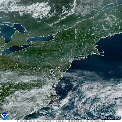
| Satellite view from Wednesday afternoon shows cloudless skies over Vermont, along with most of the rest of the Northeast. Just a few wisps of wildfire smoke visible, but not much of it. |
The National Weather Service in South Burlington says there could even be a wet snowflake or two during this on the highest peaks of Adirondacks and possibly northern Green Mountains.
This wouldn't amount to anything if it happens, and a couple wet snowflakes on mountain summits isn't weird for this time of year, but it's a sign of the season.
By the way, the date in which the record was set for the earliest snowflakes and for measurable autumn snow atop Mount Mansfield have passed.
The earliest snow flurry on record up there was on August 30, 1976. The earliest measurable snow was the 0.3 inches that fell on top of the mountain on September 2, 1967.
If you're a glutton for punishment and want early snows down in the Champlain Valley, don't hold your breath. The records for early snows in Burlington, according to the National Weather Service are as follows:
Earliest trace was on September 23, 1950, and the earliest measurable was the 0.1 inches on September 30, 1992.
For those of you who prefer the bright sunny weather we're having this week, signs are sort of pointing toward another spell of gorgeous weather once we get into the middle of next week. Fingers crossed!

No comments:
Post a Comment