Thursday, February 20, 2025

World Surprisingly Had Its Hottest January On Record This Year

Red hot world again. January was the warmest on record for
the Earth as a whole, with very few places on the
chilly side and many at record heat. 
Scientists got a surprise from the latest snapshot of global temperatures. It turns out January was unexpectedly the warmest on record for the world as a whole. 

Sure, the continental United States was chilly, as I reported in an earlier post on Monday,  but that was very much the exception

The National Centers for Environmental Information, or NCEI states: 

"The new January global record is particularly notable for having occurred during a La Nina episode, the cold phase El Nino Southern Oscillation (ENSO). Global temperatures tend to be cooler during periods of La Nina in comparison to periods with an El Nino present."

Not this time. 

 The three previous world record warm Januaries all occurred during the opposite El Nino, which tends to boost global temperatures. 

As always the NCEI data was sound, as other scientific organizations agreed with the assessment. The European Copernicus Climate Change Service, and Berkeley Earth both measured the Earth as having its hottest January on record. 

Almost the whole world was warm, with the hottest places relative to average in the Arctic, Alaska, northwestern and northeastern Canada, most of central and eastern Europe, southern South America and western Australia. 

The few cold spots were quite a bit chillier than you'd expect. Those rather small cold places were the as-mentioned central and southeastern United States, a good chunk of Greenland, far eastern Russia and a weird, very small area of southern Africa. 

NCEI still says there's only a 7 percent chance that 2025 will be the hottest year on record. 

The warm trend has been happening for long time, but is now accelerating. If you are under the age of 49, you've never seen a global January that was cooler than the 20th century average. 

WHY IS THIS HAPPENING?

 It's true that this warm January occurred during an El Nino, but it is a weak one, so it might not be having as much an effect on the world's temperature as a stronger one would. 

But I wonder if that fully explains why January was so warm. Snow cover was well below normal in the northern hemisphere. Snow reflect heat back to space, so if there's less snow, the Earth has an opportunity to warm up a little more than it otherwise would. 

But that still might not explain everything. 

One compelling explanation is clouds. Or more precisely, a lack thereof. 

Cloud cover on Earth was below normal in January, and in fact, clouds have been lacking for the past two years. Those two years have shown an alarming acceleration in the how fast the world is warming up. 

High, thin clouds tend to have an overall warming effect on the world. Low stratus or billowy cumulus clouds tend to cool us off a bit. It's those low clouds that have been lacking, explains the Washington Post. 

From above, these low clouds are shimmering white, which reflects the sun's heat back up into space much like that snow cover does. 

The next question is why there are fewer clouds. WaPo explains:

"Researchers are still unsure exactly what accounts for this decrease. Some believe the it could be due to less air pollution: When particulates are in the air, it can make it easier for water droplets to stick to them and form clouds.

Another possibility (Helge) Goesling said, is a feedback loop from warming temperatures. Clouds require moisture to form and moist stratocumulus clouds sit just underneath a dry layer of air about one mile high. If temperatures warm, hot air from below can disturb that dry layer, mixing with it and making it harder for wet clouds to form."

Goessling is a climate physicist at the Alfred Wegener Institute in Germany and is the author of one of the studies that looked at why the Earth was reflecting less heat back to space.  

Feedback loops are dangerous because they feed off each other.  If the cloud theories are correct, fewer low clouds will accelerate global heating. That accelerating heat destroys even more low clouds, which begets even more heat and so on and so on. 

Despite the temporarily chill we've been feeling here in Vermont this year, the unexpected global heat in January, plus these new studies, suggest we have more record-shattering heat in our not so distant future. 

Not just here in Vermont but throughout the entire world. 

Think it's been hot in recent years? You ain't seen nothin' yet. 


Think It's Snowy In Vermont? Let's Take A Quick Trip To Montreal

Montreal is a mess after two storms within four days
dumped 30 inches of snow on the city. Snow removal
has been slow because of the volume of the snowfall
and people are getting frustrated.
 We spent a lot of time over the past several days talking about all the snow here in Vermont, but if you really want snow, we should talk about Montreal. 

And other large sections of Quebec and Ontario. 

Two storms between Thursday and Sunday dumped nearly 30 inches of snow on Montreal. 

It was the largest amount of snow on record for such a short period of time.  The city had 40 percent of its normal annual snowfall within five days. 

Montrea[ had full blizzard conditions, which are common further north in Quebec but rare in southern parts of the province. Winds around Montreal Sunday and Monday gusted from 35 to as high as 55 mph, whipping the snow into tremendous drifts. 

Sunday's storm was slightly larger than Thursdays, depositing about 16 inches of snow on Montreal and 21 inches in Mirabel. 

Sunday's storm was the fourth largest snowfall on record in Montreal. Thursday's storm was tenth largest.  (Montreal's biggest snowstorm dropped 18 inches of snow on the city on December 27, 2012.

At least one death was reported due to the storm.  A 57-year old ma was found dead inside a snow-covered car with its engine running, Global News reports.

 It's likely the snow blocked the car's exhaust, backing deadly carbon monoxide back into the car where the man was sitting.

In Chateauguay, Quebec, just south of Montreal, a 13-year old girl was in critical condition after she was found unresponsive beneath a collapsed snowbank.  A snow tunnel must have collapsed. 

Montreal has a reputation as being at least somewhat  efficient at snow removal, but this threw the city for a loop. Schools were canceled Monday and the city told anyone who was able to work from home to do so. 

Quiet weather starting Tuesday has allowed Montreal to get the cleanup going in earnest, but officials said it could take to early next week to get all the sidewalks plowed. On Tuesday, only six percent of rte snow had been cleared from Montreal streets. So yeah, this will take awhile.

As of midweek, city streets were still treacherous. Snowbanks made street parking virtually impossible.  Adding to the chaos, pedestrians were walking in the streets because sidewalks were still blocked by snow. 

If you're contemplating a quick trip up to Montreal, I'd wait more than a week before doing it. 

The huge volume of snow is making it hard to get rid of it all. Montreal has these big snow blowers that filled one large 45-foot truck every minute to be hauled to a snow dump. The city either dumps snow into sewer chutes, where it mixes with warmer wastewater, melts, and is then treated by the city's wastewater system. Or it's deposited at dumps, including an old quarry, where the snow gradually melts in the summer. 

 Far away from Montreal, and well northeast of Quebec City, an avalanche swept across a highway and trapping cars. However, everyone escape unscathed. 

Toronto was also reeling from the dual snowstorms.  Main roads there are clear, but like Montreal, Toronto has to load snow on trucks and haul it away, which is taking forever given the 21 inches of snow that fell on Toronto in the dual storms. 

The slow pace of snow clearing in Toronto is frustration residents, much like in Montreal. 

It's unclear if the weather had anything to do with the plane crash in Toronto Monday in which a plane with 80 people on board crashed and flipped over when trying to land.  Twenty-one people were hurt, but miraculously no deaths were reported. 

The plane landed amid blowing snow and strong winds, but pilots are trained to take off and land in such conditions, so it could well have been a mechanical problem. 

Much like here in Vermont, the snow machine as shut off for now in most of southern Quebec and Ontario. Only very light snows are expected in Toronto and Montreal over the next week. In both cities, high temperatures next Monday through Wednesday could rise to levels slightly above freezing. 

Videos:

 Scenes from the Montreal blizzard. Click on this link to view or if you see the image below, click on that. 


News report shows how chaotic things looked in Montreal. Again, click on the link or if you see image below click on that:


Judging from this video, it looks like Ottawa, Canada is very efficient at removing near 30 inches of snow from city streets. Click on this link to view or if you see image below, click on that. 

 
A walk through a Montreal neighborhood Wednesday morning shows how chaotic things still are in the city. Click on this link or if you see the image below click on that. 


Wednesday, February 19, 2025

The Dark Side Of All This Vermont White Snow

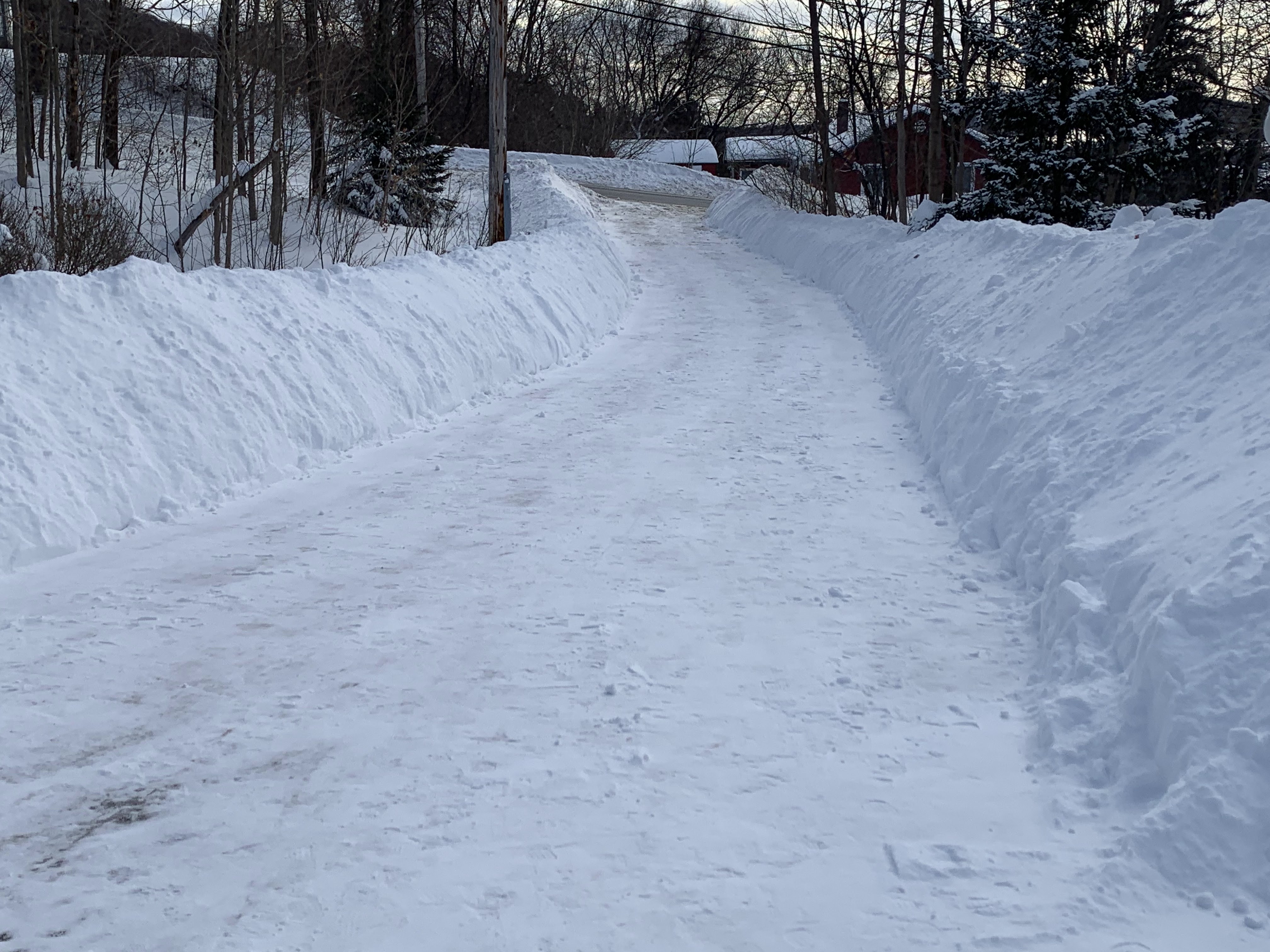
No signs of thawing yet as of today along my St. Albans,
Vermont driveway. I've decided to rename the path
Snow Canyon Drive for obvious reasons. 
 It's pretty out there in Vermont today, that deep snow glistening in today's' bright, cold February sunshine.  

The winter sports industry - skiing riding, cross country, snowshoe, snowmobiling, ice climbing, ice fishing and anything else winter - is thriving this President's Week. 

The spring melt will wipe away the last vestiges of last autumn's drought. 

Plus, it's a rare, old fashioned winter. The kind we don't often see nowadays in this age of climate change. It's a bit of a throwback to the 1970s, when the snow was always super deep and the air was always frigid.

True, this year isn't nearly as extreme as some of those in the 1970s but you get the idea. 

However, being a glass half empty kind of guy, I do have to point out the dark side of this blinding outdoor winter whiteness out there. 

This stuff can cause trouble. 

ROOF TROUBLE

It's been years since snow has gotten this deep, and some weaker structures might be in trouble with all this snow loading. 

A barn in Williamstown, Vermont collapsed under the weight of the snow Monday evening, killing at least six cows.  It was the first major structure collapse I've heard of in Vermont this year, but who knows? There might be others coming. 

In my drives around northwest Vermont, I'm noticing a lot of ice dams on roofs for the first time in a few years. That will surely lead to water leaks and interior water damage to who knows how many houses. I'm lucky at my house. Ever since we installed a standing seam roof in 2017, the snow slides off and we don't get ice dams.

However, the snow that slides off puts a LOT of weight on our back deck and that entails another rigorous shoveling job to keep the deck standing.  

It's been much worse this winter in parts of western and central New York, where the lake effect snow squalls have really been working overtime since late November, really. 

Just yesterday, the roof a a wire factory in Williamstown, New York, which is within the Lake Ontario snow belt collapsed under the weight of snow and ice.  Workers heard cracking noises in the ceiling early Tuesday and evacuated, so nobody got hurt. 

A short distance down the road from the wire factory, a church roof collapsed.

Elsewhere in New York, a business collapsed under the snow near Rome, New York. A Walmart Super Store in Central Square New York temporarily closed over concerns regarding snow on the roof. They hope to reopen once the snow is removed. 

SALT SHORTAGE

Expect Vermont roads to be even worse than usual during and after any remaining snowfalls and mixed precipitation episodes we see before spring sets in.

Vermont is among a number of states facing a road salt shortage. 

The town of Lyndon is almost completely out of salt. St. Johnsbury is reserving what little salt they have and only treating roads once storms have ended, reports WPTZ.

No word yet on how that will affect the Vermont highway department and other towns. But I bet they're conserving salt. 

CLEARING SNOW

If you have a fire hydrant near your house, head out and clear away a big patch of snow away from the hydrant if you have not done so already. Shovel a path from the road to the hydrant, and push the snow at least three feet away from the hydrant in every direction, 

Go around your house to see if there are vents or other equipment that are blocked by snow or nearly blocked. Vents especially can back up dangerous carbon monoxide into a house if the snow if blocking them. 

Got a mailbox out front? This is hard because of all the rock solid stuff plowed from the road, but try to clear an indentation so the mail vehicle can reach your mailbox without getting stuck.  Try to make it so they can move forward without getting stuck after dropping off your mail. 

Do you heat your house with heating oil?  Or propane?  Getting low on fuel and need a delivery? Make sure you've cleared a path so that the delivery person can make it to the intake easily to fill your fuel tank. 

My brother in law is a former fuel delivery driver and he has nightmare stories of trying to drag the hose through snow a few feet deep to reach the intake. Do them a favor. 

SPRING FLOOD?

Believe it or not, as of last Thursday, most of Vermont was considered "abnormally dry" and a small portion of southern Vermont was still regarded as in drought. 

I think that' mostly because it has pretty much just snowed and sleeted in recent weeks. Moisture from all snow is yet to make it into the ground and our rivers and streams.

This weekly drought monitor will be updated tomorrow, so it will be interesting to see if there are any changes. The National Weather Service in South Burlington will also update their biweekly late winter/early spring outlook tomorrow. 

Since January, those updates have rated the risk of flooding below normal, mostly because no big thaws are in the offing. That's still true. But in January, snow and the water equivalent in the snow was below normal. Now I expect the snow depth and water equivalent to be at or above normal. We shall see.

So, as I mentioned earlier in this post, this snow is good news.

Unless it isn't. 

If the snow melts very fast toward spring and is accompanied by heavy rain, we'd end up with some pretty nasty flooding. That's especially true since river ice is thicker than it's been in a few years. A sudden thaw could break up the ice and create ice jams. Which cause flooding. 

The best scenario would be if we have a perfect maple sugaring March and April. That means warm, mostly dry days and hard overnight freezes. Preferably daily. 

 That would cause a gradual snow melt. The moisture would just soak into the ground and we'd start our growing season with plenty of water sitting there to keep our gardens and crops happy.  

Winter Storm Battering Flood Ravaged Kentucky As Nation's Intense Winter Weather Continues.

 Kentucky just can't catch a break.

Flooding with snow on the ground in
Kentucky on Sunday. A winter storm
is dumping several inches of
additional snow on the flood-
ravaged state this morning. 
The death toll from this past weekend's flooding in the state has risen to 14. An additional three people died from the flooding in adjacent West Virginia. 

The flooding hit all of Kentucky, from near the Mississippi River in the west to the Appalachians in the east.

The flooding prompted something like 1,000 water rescues, and at least 300 roads were shut down by the high water.  

The flash flooding from the weekend is over, but some rivers haven't crested quite yet. Moderate and sometimes major flooding was still going on along at least three Kentucky rivers as of early Tuesday morning. 

Now, a winter storm is about to hit Kentucky, with two to six inches of snow falling on the flood zones tonight and Wednesday. Temperatures are expected to fall into the single numbers Wednesday and Thursday nights

This weather misery comes as Kentucky has endured other outsized disasters in recent years. 

In December, 2021, a swarm of tornadoes in Kentucky killed more than 80 people and left trails of destruction behind. 

An enormous Kentucky flash flood in July 2022, left 45 people dead and left widespread destruction. 

Now this.  

It's hard enough to start digging out from a flood in warm weather. Imagine trying to do it while temperatures are well below zero and there's a few inches of snow on the ground. The mud freezes into a hard concrete, so you can't shovel it away. Wet items that need to be removed from wrecked buildings are frozen together. 

People trying to deal with all the wet, destroyed property are especially prone to hypothermia and frostbite. 

It's really a tough week in Kentucky,

The rough late season winter blast isn't just affecting Kentucky. Winter storm warnings extend to the Carolina and Virginia coastlines, where five to nine inches of snow is forecast.

Extreme cold warnings and advisories extend from Montana and North Dakota all the way down to the Gulf Coast.

Minot, North Dakota was enjoying a comparatively mild morning today as it got down to 23 below.  It was 33 below there Tuesday morning and 30 below Monday.  Those are actual temperatures, not wind chill. 

The frigid temperatures and snowstorms are forecast to at least temporarily relax over the next few days, giving some places, mostly areas west of the Mississippi River an early taste of spring next week.

VERMONT EFFECTS

For once, a storm is going to miss us completely. First time that's happened all month\

The winter storm that's been hitting from the Midwest to North Carolina and Virginia is going to eventually evolve into a pretty substantial nor'easter. But it will be far, far off the coast, passing about a couple hundred miles southeast of Cape Cod.

Instead, it'll stay very cold today and to extent tomorrow before a slow warming trend arrives. A weak disturbance could put down a dusting to two inches of snow Thursday, but nothing big for a change. 

We will still probably get into a brief warm-ish spell Sunday through to the middle of next week, where valleys should get above freezing daily, maybe even 40 degrees in the banana belt towns. 

But this does not herald spring.  The overall trend is for colder than average weather well into March, at least as it looks now. 

Tuesday, February 18, 2025

Vermont Snow Cover Likely Deepest In Years

House in St. Albans, Vermont slowly disappearing behind
big mounds of snow. A couple piles on the edge
of my driveway are now seven feet tall.
The weekend snowstorm brought the amount of snow on the ground in most of Vermont to the deepest level in years.  

Snow cover is now arguably the deepest it's been since either 2017 or 2019 in much of Vermont. Maybe even before that in a few spots. 

A large number of Vermont towns have at least two feet of snow on the ground. A few towns are at or above three feet. Greensboro reported 39 inches on the ground Monday morning. Westfield had a 38-inch snow cover while Sutton had a mere 34 inches.

In Burlington, the snow depth reached 19 inches on Monday. The last time Burlington had a deeper snow depth was on one day, March 15, 2017, the day after the big Pi Day Blizzard that year. The deepest snow cover on record in Burlington, by the way, is 33 inches. 

Up near the top of Mount Mansfield, there was an impressive 95 inches of snow on the ground, compared to the average for the date of 61 inches. Only four of the past 70 winters had more snow at the Mount Mansfield stake on February 17 than this year. 

Very little snow is in the forecast for the next several days so those deep totals will probably settle a few inches this week. On the other hand, temperatures are forecast to remain below freezing until probably Monday. And even then, it'll only get into the 30s. 

As irrefutable proof that I am indeed 100 percent bat
crap crazy, yes, I hand shoveled this snow canyon
that is my driveway in St. Albans, Vermont. 
The snow cover has been aided by a lack of thaws. It has only reached 40 degrees twice this year so far in Burlington. The last time it happened was on January 18. when it barely reached 40.  With only brief mini-thaws, the snow cover has been able to build and build. 

The snow is deep, but we're not breaking any records here in Vermont. 

Way back in 1829, according to David Ludlum's Vermont weather book, there was 60 inches of snow on the ground in Newfane. 

After a large February snowstorm in 1952, the mid-February snow depth reached 40 inches in Northfield and 48 inches in Somerset. 

The record snowy winter of 1970-71 led to some incredible snow depths by early March. Orange, Vermont 88 inches of snow on the ground on March 7, while Montpelier reached a depth of 70 inches. 

We have time this winter to build up a deeper snow cover if more storm comes along, but the season is now working against us.

As average temperatures warm as we head toward the month of March and spring, it's getting easier and easier for temperatures to rise above freezing. 

The normal  high temperature in Burlington on February 1 was 29 degrees. Today, February 18, the average is 32 degrees. By March 1, a normal day in Burlington would bring a high temperature of 36 degrees.

Your yard my be buried beneath two or more feet of snow right now, and your snow banks might be taller than you are.  Believe it or not, though, it won't be long before you see the grass on  your lawn again. 


Monday, February 17, 2025

As Expected Monday Was Very Windy Day, Scattered Outages, Frigid, Windy Tonight, Tuesday

A cold, windy day comes to an end in St. Albans,
Vermont today after I (mostly) finished digging
out of our big weekend snowstorm. My aching 
muscles can take a break, as not much more
snow is in the forecast over the next week. 
 Well, we made it through another windy, cold winter day in Vermont and now we're hunkering down for a  frigid winter night.  

THE WIND

As expected, winds howled from the west and northwest.  Highest gusts reported so far today include 66 mph in Jay, 61 mph in Lowell, 60 mph in Gifford Woods State Park in Rutland County, 54 mph in Springfield and 53 mph in Montpelier.  

I think there were stronger winds in parts of southern Vermont, since power outages today were mostly focused down there. 

I do see a report of a 58 mph gusts early today in Searsburg and 56 mph in West Dover, but I haven't seen any updates this afternoon from that part of the state. 

Power outages wavered up and down in Vermont today as gusts ripped down some power lines, then they were fixed, only to have other power lines blow down in the wind.  

So far today, the most outages at any given time was about 4,100 at around 2:30 p.m.  For most of the day, outages ranged from roughly 2,500 to 3,000.

I imagine there will be a few more outages as winds continue to crank into the evening. They'll gradually diminish overnight, but it will stay gusty all night and through tomorrow. That''ll keep things pretty damn cold. Worse than today.

THE COLD

In some parts of Vermont, the sun came out off and on as skies cleared a little sooner than forecast. That allowed temperatures to climb all the way up to the upper teens to low 20s. That's still way colder than normal for this time of year. 

Those winds made it seem a lot colder than that, though. 

Cold air is continuing to pour in, so it will get even more frigid.  The cold weather advisory for the northeast quarter of Vermont is in effect overnight as temperatures plunge to a little below zero and wind chills reach the 20s below. 

Elsewhere, it'll feel like teens below zero.

There's a decent but not certain chance that Tuesday might be the coldest day until next winter. Many places won't get out of the single digits, and those who do only make it the low teens. 

Wednesday won't be much better with another early morning sitting with temperatures within a few degrees either side of zero and highs only in the teens. 

If you want to look forward to something, a gradual warming trend still looks like it want to take hold toward the weekend. Some areas might even be a few degrees above freezing by next Monday! 

THE SNOW

Not much snow fell anywhere in Vermont Monday, which is good, as we kind of need a break. An inch, two or three inches of windblown snow did come down over the northern Green Mountains and Northeast Kingdom but that was just icing on the cake. 

One weird thing showed up on radar today. An intense lake effect snow band developed all the way over at Lake Huron. The snow band eventually crossed Lake Ontario where it took on more strength. 

The strong winds today kept that snow band going all the way to southwest Vermont and northwest Massachusetts, where occasional mostly light snow fell all day. 

Elsewhere, blowing snow was the big issue, as road conditions remained iffy in many areas due to all that snow blowing back into the roads in wind-exposed areas. 

Meanwhile, back country skiers and ice climbers who want to take advantage of all this new snow ought to be wary. Avalanches are possible in steep terrain of the Green Mountains and Adirondacks, says the National Weather Service in South Burlington.

(Hell, a couple of the huge snowbanks in my driveway that are taller than I am partly avalanched back onto my driveway so I get it). 

I'm making jokes, but avalanches, even in Vermont can be dangerous and/or fatal, so be careful

In New Hampshire, the National Weather Service office in Gray, Maine issued an avalanche warning for the Presidential Range, including Tuckerman and Huntington ravines. 

As far as more falling snow goes, flurries and mountain snow showers will make occasional visits to Vermont this week, but for a change, there's no big storms on the horizon. 


American Exceptionalism? Lower 48 Of U.S. Cold While Rest Of World Had A Hot January, 2025

Unlike most of the rest of the world, large
sections of the United States were cooler than
normal in January, 2025 (blue shading)
 Early data suggests the world had a record to near record hot January, 2025, but the United States, at least the Lower 48, didn't join the climate change hot party. 

I'll have another post with more details on global data very soon. But let's look at the United States first, courtesy of NOAA's National Centers for Environmental Information.

As almost all of the rest of the world basked in odd January warmth, it was a remarkably chilly January for the U.S. if you don't count Alaska and Hawaii. It was also incredibly dry. 

THE COLD

It was the 33rd coldest January out of the past 131 years in the Lower 48. It was the coldest January since 1988.

January bucked a trend toward warmer and warmer months thanks to climate change. Despite a warmer world, cold weather patterns can still develop, creating individual months that harken back to a colder time a few decades ago.

I hope you liked the chill of January, 2025, as this type of winter month will keep getting more and more rare. 

No state managed to have one of their top ten coldest Januaries, but nine states had one of their top 20 coldest Januaries. Few states were on the warm side. Only California, Oregon, Washington and Maine were a bit on the mild side. 

Meanwhile, Alaska has its 8th warmest January out of the past 101 years. 

THE DRY

It was sixth driest January on record across the U.S., too, as we really lacked the usual dynamic storms that regularly sweep across the nation in January, 

Seventeen states, including Vermont had one of top 10 driest Januaries this year. (Here in Vermont it was eight driest).  

Most of the U.S. was dry in January too. Anything
in beige or brown was dry on this map. Overall,
the Lower 48 had its sixth driest January on record. 

There were no states that were on the wet side, which is very unusual since in any given month, the nation is usually divided into wet areas and drier ones.  This time, everybody seems to have missed out on the precipitation. 

There were some relatively wet pockets in some states in the northwestern and central Plains, and in northern Florida, but they weren't enough to skew state averages to the wet side. 

About 42 percent of the nation was officially in drought in January, up about 4 percent from the end of 'December. 

This dryness was punctuated by the nation's first weather/climate related disaster of the year. Barely a week into the New Year, the extremely devastating California wildfires began,  At last check, the toll was 29 dead and 16,000 structures destroyed. 

Those fires have finally gone out as southern California has finally entered a somewhat wetter weather pattern. 

It seems does like there's a slight shift in February going on that should make the U.S, relatively warmer and wetter compared to average.  It won't be another January, but it still seems like it might turn out to be a slightly colder than average month for the Lower 48. 

The northern tier of the nation will probably still come out as cold in February, so the nation as a whole   will almost certainly not be among the warmer Februaries we've had. 

Unlike in January,  an active storm track from the the West Coast clear across to the Eastern Seaboard for much of this month will ensure a fairly wet February. Especially compared to January,