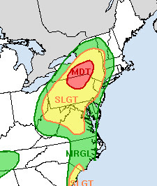
This storm will continue to cause flooding issues Do note southern Vermont is once again in the flood risk zone because of ex-Fred.
There were no fewer than 13 tornadoes in the Carolinas and Georgia spun up by Fred on Tuesday. Flash flooding struck the mountain near the North Carolina/Tennessee border.
Though details were still sketchy as of this Wednesday morning, there are reports of homes either swept away or damaged by extensive flooding in this area.
The center of what was Fred was over West Virginia early this morning, and flash flooding was rushing down the steep slopes of West Virginia's mountains this morning.
The remains of Fred will continue to bring tons of tropical moisture and dump it as torrential downpours today in Pennsylvania and southwestern and central New York. There's even the risk of a few more spin up tornadoes in Pennsylvania and Maryland today, we'll see.
Today, that Fred-related wet air will focus on Pennsylvania and New York today, where plenty of flash flooding is expected today on already sodden ground. Then move into southern and central New England tonight, which brings us to what's going to happen in Vermont
VERMONT IMPACTS
Humid air out ahead of Former Fred flooded into Vermont Tuesday causing lots of showers to break out, but none of them were particularly heavy.
A torrential rain band that caused flash flooding in western New York was continuing to feed into central Vermont this morning in a weaker fashion. There's no flooding there today, but rainfall has been heavier in that zone. I'm sure a few spots halfway between Route 4 and Route 2 picked up a half inch or more of rain. There's probably been an inch of rain in a few spots in western Addison County.
The showery state of affairs is continuing this morning, though the showers might temporarily wane somewhat by this afternoon. Then we start to deal with Ex-Fred.
Forecasting the evolution of former tropical storms that are well inland can be tricky, as a small shift in the expected path could make a big difference.
But at this point it looks like Ex-Fred will move through central New England late tonight and Thursday, possibly as far north as the southern borders of Vermont and New Hampshire.
This would spread heavier rain through the southern half of Vermont, and maybe up the Connecticut River Valley toward St. Johnsbury as well.
Current forecasts call for more than two inches of rain in southern Vermont. Perhaps much more if things line up correctly. That would set this part of Vermont up for the third flash flood of the summer. Bennington and Windham counties are already under flash flood watches, given the possibility of up to four inches of rain there.
Soils down there are still awfully wet, so it wouldn't take all that much precipitation to set off some flooding.
The amount of rain from Ex-Fred would diminish quite a bit as soon as you get north of Route 2. That's the current prog, anyway. Best guess is an inch or a little more of rain south of a Burlington to Newport line. The far northwest corner of Vermont would see a half inch or even less.
There's always the chance that the heavier rain could work itself further north, which would actually be OK. Far northern Vermont could still use more rain, though drought conditions have eased a little there.
This will already be the second time this year that a former tropical system affected Vermont. Former Hurricane Elsa dumped heavy rain on southeast Vermont in early July, causing some spotty flooding.
There is a low, but not-zero possibility another tropical system might affect Vermont in the near future. Tropical Storm Henri. It's buzzing around Bermuda and expected to become a hurricane. Forecasts have been calling for Henri to turn toward the northeast eventually and pass safely off the New England coast.
However, some forecasts build a ridge of high pressure over southeastern Canada, and that would steer Henri closer to the New England coast. That's still really iffy, so we'll just need to keep an eye on it.


No comments:
Post a Comment