 |
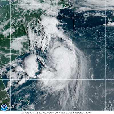
Tropical Storm Henri was starting to look a little more symmetrical off the coast of North Carolina this morning, setting the stage for a brief period of intensification into a hurricane today. |
Even if it's slow to turn into a hurricane, Henri still means big trouble for parts of southern New England and New York.
There will be impacts from Henri in Vermont - pretty much a flood risk - but there are still questions as to how bad and exactly where that flooding might be in the Green Mountain State.
By the way, there are some other hazards in Vermont to think about before Henri makes landfall. I"ll get to those after we get through our Henri walk through.
Forecasts continue to show Henri as an odd duck.
Tropical storms and hurricanes have throughout history hit New England in August so that's not weird. The expected northwestward bend in the track before landfall, taking Henri toward Long Island and Connecticut is weird.
Henri's expected very forward slow motion through New England and the Hudson Valley is unprecedented from what I can tell. That track is not set in stone, either. Henri could go a little west of that predicted path, or somewhat more likely, a little east of that path.
This weirdness could reduce the area battered by high winds, but worsen the inevitable flooding from the storm.
Long Island and Connecticut, and probably Block Island, Martha's Vineyard and Nantucket are in the most danger from storm surges and wind damage. I'm sure there will be massive power outages, tree damage and some structural damage there. Henri is expected to come ashore Sunday afternoon as either a Category 1 hurricane with winds of 75 mph, or a strong tropical storm with wind speeds just under that.
Storm surge flooding along Long Island beaches will be pretty intense with this. People on Long Island, in Connecticut, Rhode Island and nearby areas should be finish gathering supplies, food and water today to prepare themselves for long power outages. Note these outages will happen amid oppressive humidity next week, so that in itself will be a danger.
Tropical storms and hurricane winds almost always rapidly weaken after they come ashore, and Henri will be no exception in that regard. As Henri slowly makes its way north - current forecasts have it crawling to about Albany, New York early Monday morning - winds will die out.
By the time Henri starts to affect southern Vermont, there might be some gusty winds, maybe a few power outages and trees down, but there probably won't be horrible wind damage in Vermont.
Torrential rains tend to linger much longer with decaying tropical storms, and this will happen with Henri. This is where Henri's slow forward motion gets dangerous. The heavy rain will linger over Connecticut, southern New York, western Massachusetts and quite possibly southern Vermont and southern New Hampshire for a long time.
That could cause catastrophic flooding. At this point, that seems most likely in Long Island, Connecticut and New York's Hudson Valley and Catskills.
Far southern Vermont is on the edge of this torrential rain prediction. It's possible, with its western track, a bit of dry air can get pulled into the dying circulation of Henri from the east, slightly reducing rainfall. But don't count on that! I'm still definitely worried about flash flooding in southern Vermont.
That's in part because the forecasting models haven't settled on the focus for the heaviest rain. Some forecast the worst of it to be in the Catskills. Others target Connecticut, the Hudson Valley and Massachusetts. Others take the heaviest rain through Connecticut, central Massachusetts, New Hampshire and southern Vermont.
Anybody in the southern two thirds of New England should monitor flood forecasts through tomorrow night.
The worst of the rains there would come Sunday night and Monday morning.
The remains of Henri are still forecast to take a sharp right turn through central New England and on into the Gulf of Maine. If this goes as expected, that's great for most of central and northern Vermont. That means there wouldn't be enough rain to raise a flood threat.
The usual caveats apply: There WILL be shifts in the expected track, strength and orientation of Henri. That means forecasts for the heaviest rain, the strongest winds and the timing of the storm will shift, too.
That means keep a heads up with forecasts, especially those of you in southern Vermont who are at most risk of flooding with this.
Before we get hit with Henri, we have those other hazards that I mentioned to consider.
It's wicked humid out there, and with expected high temperatures into the upper 80s today, there's a heat advisory up for Vermont's Champlain Valley. The heat index will be in the mid-90s, so take it super easy out there.
Another thing to look out for are hit and miss showers and thunderstorms. They won't be severe, but a few could contain really torrential downpours. Since we're in bizarro world in the weather department, these storms won't come from the west as usual, but from the east or southeast.
So contrary to what we usually experience, if you see dark clouds to the west, you're probably OK, but if there's threatening skies to the east or southeast, take cover.


No comments:
Post a Comment