 |
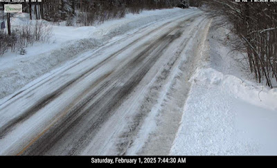
| Traffic camera picked up a winter wonderland with nice dawn colors after last night's snow along Route 7 in Shaftsbury, Vermont this morning. |
That tired cliche where if you don't like the weather in Vermont it will change in a minute seems to be especially true lately.
As of early this morning, snow totals from last night are hard to come by as reports haven't really come in yet. I do see 5.2 inches in Norwich, down in Windsor County and 4.5 inches in Landgrave, which is in far southern Vermont.
Roads were still slick in spots across central and southern Vermont early this morning, so take care on the highways.
It was nice to see southern Vermont get the snow for a change. For the past month, any snow we have gotten has been mostly focused on the central and northern Green Mountains.
 |
| Route 302 in Topsham was still pretty snow covered as of 7:30 this morning so take care on the roads in central and southern Vermont until things are cleaned up after last night's snow. |
Further north, here in St. Albans Friday's snow completely missed us, though we were getting a few flurries early today due to the frigid air blasting in from Quebec.
In the Champlain Valley, there's still enough ice-free water on the lake to help produce some lake affect snows in parts of Chittenden and Franklin counties this morning.
A few places could get one to three inches of fluff before that ends probably by noon or so.
BRIEFLY FRIGID, AGAIN
Temperatures that were in the 30s in many places Friday afternoon were in the low and mid teens just before dawn today. Those readings will either stay steady or slowly fall through the day, even as the sun comes out in many areas this afternoon.
That sets us up for what will for many of us be the coldest night of the winter so far. Which really isn't saying much since most of us have never been colder than the single numbers to teens below zero so far this season, which isn't all that wild. The record low in Burlington Sunday is 25 below, and we'll get nowhere near that.
Even so, tonight, clear skies, light winds, Arctic air and snow cover will ensure it gets plenty cold. The National Weather Service in South Burlington is going with an expected low of about 6 below in Burlington, to the low teens below in many areas, and low 20s below in the cold hollows of the Northeast Kingdom.
All that's no where near record cold, but it will feel plenty nippy.
SUNDAY/MONDAY
 |
| Only one to three inches of snow are expected in our next round Sunday night, with a brief that likely for many of us on Monday. |
By late afternoon, most of us will be in the 20s. Which means it will be a whopping 30 to 40 degrees warmer than it was at the start of the day.
A warm front passing through Sunday night will give us a burst of light snow, with most of us getting one to three inches. A little less than that perhaps in the Champlain Valley.
We'll have some "wrong way" temperatures overnight Sunday into early Monday as temperatures stay steady in the 20s or slowly rise toward the low 30s.
That brings us to Monday, and a brief thaw. Warmer valleys get into the low 40s with some light rain showers around. That'll be one peak in our roller coaster ride as those temperatures rocket downward again by Tuesday.
TUESDAY-FRIDAY
The Tuesday cold snap won't be as bad as tonight's but by Tuesday night, we should be back down in the single numbers above zero, with a few places in minus territory.
But fear not! The temperature goes right back up again. We can't have more than 12 hours of one type of weather before things switch again, right?
There's still a lot of questions about the next warm up and storm Wednesday to Thursday. But it has the potential to be bigger than these piddling little things we've had for the past month. Preliminary forecasts have it going by to our northwest.
That would be a snow to rain scenario with a thaw. If it gets really warm and rains a lot, we could have trouble with a bit of flooding, actually.
We have much more ice on rivers this winter than we did the previous two. That means ice jams are more likely this year during thaws. That'll be something to watch. If not next week then later in the winter or early spring.
I wouldn't worry too much yet. It might not rain much, or the storm track will shift and it might end up being a little colder than the forecasts right now are saying. Some forecasts depict a weaker storm passing to our south, which would give us light snow instead of a thawing rain.
Given our roller coaster weather pattern, that late week warmth probably won't last long. Chances are we'll be in the deep freeze again next Friday or Saturday.

No comments:
Post a Comment