Showing posts with label Ohio. Show all posts

Saturday, December 7, 2024

Great Lakes Snow Collapses Buildings, Will Forecast Rain Make It Worse?

Firefighters and other municipal workers removing snow
from an Erie County, Pennsylvania fire station that
threatened to collapse under the weight of five feet
of snow that fell in the past week. Rain in the 
forecast Monday will add weight to the snow, possibly
triggering new collapses.
The long lake effect snow siege near Lakes Erie and Ontario in parts of Ohio, Pennsylvania and New York are pretty much over as of this afternoon, but more trouble for that zone looms. 

The snow has got to melt at some point, and that process should start Monday. 

That's what's about to cause some new issues. 

So much snow has come down in those lake effect snow zones in Ohio, Pennsylvania and New York that buildings are starting to creak and crumble under the weight. 

Already, the roofs have been coming down. In Ashtabula, Ohio, there were six roof collapse in just a single day after some parts of the city had as much as five feet of snow. So far, no injuries have been reported.

Among the collapses in Ashtabula was a partial roof failure at a high school in the city. 

In Jefferson County, New York, two separate roof collapses destroyed a house and a barn. The barn collapse killed 20 cows. Jefferson County is the area around Watertown, New York. At least a couple businesses suffered roof failures in Erie County, Pennsylvania.  

The lake effect snow machine is shutting down for now as a new weather pattern takes hold. But that new pattern threatens to cause new headaches in these hard hit, snow-buried towns. 

Namely, forecast call for warmer temperatures and rain in the upcoming week. 

At first, the rain will be bad for the snow blasted snowmelt towns near the Great Lakes, as the rain will soak into the deep snow, making it even heavier. That threatens more roof collapses.

Those big piles of snow on the ground will also block storm drains that accept water from rain and melting snow. That means street and basement flooding could easily become an issue in the worst-hit towns. 

Erie, Pennsylvania officials are scrambling to push snow piles away from storm drains and are urging residents to do the same.

In Northeast Ohio, where up to five feet of snow from Lake Erie piled up, residents are being put on alert that if their basements are prone to getting wet, be prepared for a long week. Residents are being told to remove items they can from basements to prevent damage. Water and restoration companies are gearing for a busy few days. 

One saving grace: Early forecasts hint that the heaviest rain this coming week will hit east of the Great Lakes snow belt zones, mainly in New England. But up to an inch of rain could fall on northeast Ohio, northwest Pennsylvania and western New York by Wednesday night. 

Sunday, April 14, 2024

Weird Little Storm To Spoil Sunday Vermont Outdoor Plans, Severe Weather Pennsylvania

An odd little storm is expect to create a severe
weather outbreak today mostly in the yellow
and orange zone. The same storm will
spoil Vermont's sunny start to Sunday with
light rain and cooler temperatures this afternoon. 
Usually when there's severe weather outbreaks this time of year, a large scale storm will move through the middle of the nation.  

That type of storm draws big plumes of warm, humid air northward, setting the stage for wild thunderstorms and tornadoes somewhere in the Plains or even eastern United States.

We expect an outbreak of severe weather today in a smaller area due to just one weird little storm. It's a storm that will affect us in Vermont, but with dreary tame showers and nothing scary. 

It's a small cute little thing compared to a lot of storms. It was near Lake Huron this morning, and will zip through central New York and central New England today and tonight. 

Normally, we expect just scattered light showers out of something like this, but the little storm has a surprising amount of oomph to it. 

It was gorgeously sunny to start today here in Vermont, but clouds will rapidly fill in. It will be raining in most places by the first half of the afternoon. We won't get a lot of rain - a tenth to a quarter inch - but the promise is another sunny Sunday we saw this morning won't happen. 

We're just lucky this little storm is either going by just to Vermont's south or maybe nearly overhead if you're in far southern Vermont. We're just in for a chilly light rain, we'll survive that.

SEVERE WEATHER

South of the storm, an odd area of severe weather is in the cards today.  

A band from eastern Ohio, through Pennsylvania and maybe just into the southwestern Catskills of New York is in for a day of severe thunderstorms with powerful winds and maybe a few tornadoes. 

Cold air aloft, moisture pooling near the Earth's surface and a cold front with this little storm seem destined to power up a line of big thunderstorms. Straight line winds with a squall line seem like the biggest threat in Pennsylvania. But a few storms might get going ahead of the squall line, which could produce a tornado risk.

Kinks in the line of storms later today might be spots where tornadoes can spin up, too.

Ohio and western Pennsylvania seem to be ground zero for severe weather so far this spring. Which is odd, as March and April storm and tornado outbreaks are usually further south this time of year. 

Ohio has had 29 tornadoes so far this year. Their average for an entire year is 21 twisters. Most of Ohio's tornadoes hit on February 27, March 14 and April 2.   May and June are usually Ohio's big tornado season.

Western Pennsylvania has been hit by two big flood events in the past few weeks. Luckily, this latest storm should move too fast to renew the flooding there. 

NEW OUTBREAK

A more traditional larger springtime storm is set to power up in the Plains tomorrow and Tuesday, which will create more tornadoes and hail storms across much of the Plains and Midwest. 

That bigger storm will eventually affect us here in Vermont, but it will be falling apart on its way here. We can just expect fairly light showers late this week from that system. 

Thursday, April 11, 2024

Followup: Cleanup Begins After Southern Tornadoes, Floods, Ohio Under The Gun Today

Tornado damage in Slidell, Louisiana on Wednesday
As expected, the South was swamped by severe weather and flooding Wednesday, and more storm damage was spreading eastward and northward today. 

No extreme tornadoes are known to have touched down, but several twisters caused quite a bit of damage in some towns from Texas to Florida, shredding businesses and smashing homes along the way. 

Much of the worst damage was right along the Gulf Coast rather than further inland. Tornadoes usually hit somewhat further north.  Usually when Gulf Coast towns are trashed by storms, it's almost always a hurricane or tropical storm instead of tornadoes. 

Some examples: An EF-2 tornado packing winds up to 120 mph hit parts of Port Arthur, Texas before dawn Wednesday. At the same time, a flash flood emergency was in effect in the area due to torrential rains. Those came both from the thunderstorm that caused the twister and a series of storms that preceded it. 

The same situation hit Slidell, Louisiana, a city sandwiched between Lake Pontchartrain and the Gulf of Mexico a little northeast of New Orleans. Like Port Arthur, Slidell also simultaneously dealt with a tornado that trashed buildings in town and widespread flash flooding that invaded other homes and businesses.

Inspections of the damage are just starting so we don't yet have a determination of how many tornadoes touched down yesterday. 

New Orleans, caught between the two tornadic storms, escaped any twisters, but ended up being overwhelmed by flooding. More than four inches of rain fell there within three hours and a total for the day of 6.24 inches. 

FLORIDA

The storms continued on overnight, causing additional damage in the Florida panhandle.

The line of storms extended into the Gulf of Mexico since yesterday.    That line headed steadily eastward and has been making landfall on the central west coast of Florida this morning and early afternoon. There have already been reports of possible tornadoes and severe wind in western Florida. The threat continues all afternoon. 

OHIO AGAIN

For some reason Ohio and surrounding areas  has been repeatedly raked by tornadoes and severe storms since mid-March. 

They might do it again today.

Especially if some clearing can take place this afternoon to help destabilize the atmosphere, more supercells and possible tornadoes could strike eastern Ohio, western West Virginia and maybe southwestern Pennsylvania today. 

The tornado threat should ebb temporarily in the United States Friday through Sunday. A new storm will greatly revive the threat of severe storms and tornadoes starting next Monday in the center of the nation. 


Tuesday, April 2, 2024

Potentially Deadly Severe Weather/Tornado Outbreak Looms Today In Midwest, East

Areas in yellow, orange and especially red are at risk
for tornadoes today. Some tornadoes might be strong,
long lasting and have a fast forward motion. 
The same complex storm system that has us set up for a winter storm here in Vermont this week is causing plenty of even more dangerous weather in much of the nation.  

This will probably be another storm that causes more than $1 billion in damage. That's because it's hitting so many areas with such a wide variety of dangerous weather. 

Between the giant hailstones in populated areas, the tornadoes, the high winds in severe thunderstorms, the flooding, the power outages and tree damage expected in the interior Northeast and coastal flooding along the East Coast, this one will be expensive.

Already, no fewer than three tornadoes hit parts of the Midwest and Plains Monday, though certain other twisters will be confirmed as meteorologists examine the damage today. 

Perhaps worse, big hailstones hit a number of busy towns and cities in Texas, Oklahoma, Missouri and other states. One storm in Texas produced grapefruit sized hail. Many other communities saw hail the size of tennis balls or baseballs. 

Winds in some storms gusted as high as 88 mph 

Today, severe weather forecasters are especially worried about Ohio and Kentucky. Ohio has already been hit by destructive tornadoes this year, and it's early in the storm season.

The set up today looks potentially extra dangerous. 

An initial wave of severe storms swept through southern Illinois, Indiana and Kentucky early this morning, producing several tornado warnings and possible actual tornadoes.

Quite a bit of damage was reported with this initial band of storms, and more problems were cropping up before noon as this line swept into West Virginia.  

Famous photograph of a huge tornado in Xenia, Ohio
back in 1974.  Forecasters fear large tornadoes 
could once again hit Ohio today. 

Those storms will clear out by this afternoon, setting the stage for what could be even more powerful supercells this afternoon. 

NOAA's Storm Prediction Center says there's a risk of strong, long-lived tornadoes in Ohio and Kentucky this afternoon and evening.

It's usually time to worry when they start throwing words like that around. 

The numerous intense storms are also expected to have a fast forward motion, meaning they might not be a lot of time for residents to take cover if they are warned about an approaching tornado.

The area around the Ohio River Valley under that tornado threat today is no stranger to big tornado outbreaks during March and April.  The area around Indiana, Ohio and Kentucky suffered through massive, deadly tornado outbreaks during the Palm Sunday Outbreak of 1965, the famous "Super Outbreak" in 1974 and a big swarm of tornadoes in March, 2012,

Friday, March 15, 2024

Worst Tornado Outbreak So Far This Year In Midwest, South

Serious destruction in Indian Lake, Ohio. Photo from 
From Above Aerial LLC
Thursday and Thursday night's severe weather outbreak in the Midwest hit with unexpected fury, spinning off tornadoes that killed at least three  people and left dozens injured.  

The tornadoes on Thursday seemed to concentrate their fury on Indiana and Ohio, where several strong tornadoes were reported.

Logan County, Ohio was reportedly especially hard hit. 

Videos posted on social media showed intense looking tornadoes sweeping across the late winter landscape of Ohio. 

Another powerful tornado caused severe damage and perhaps dozens of injuries in the adjacent towns of Winchester and Selma, Indiana. 

Indiana and Ohio were not the only states hit. Suspected tornadoes also struck Arkansas and Texas. As of mid-afternoon, fifteen tornadoes had been confirmed. Officials with National Weather Service offices in damaged areas are still doing storm surveys to obtain a full count of the number of twisters. 

The tornado and tornado alerts extended a huge 1,000-mile distance from northern Texas to northern Ohio. And here's an oddity: The line of intense storms extended almost exactly along the path of the upcoming April 8 total solar eclipse. Except of course there was no dangerous weather along the eclipse path in New York, Vermont and beyond. 

Tornado activity as intense as Thursdays is rare for as far north as Ohio this early in the season.  

It's been that kind of early storm season so far. Wisconsin had its first February tornado on record.  Tornadoes in early March were reported as far north as Michigan and southwestern New York.  Ohio was also hit in late February as six tornadoes spread widespread damage in the middle of the state. 

Some tornadoes are possible in the South today, but the activity shouldn't be as intense and tragic as it was Thursday. 

After today and for the next week or so, tornado and severe weather should be fairly low key. However, long range forecasts seem to indicate a weather pattern more conducive toward tornadoes and hail toward the end of this month. 

That long range forecast is not cast in stone, but the U.S. is now in that dangerous season of tornadoes and giant hail. 

Tuesday, November 28, 2023

Snow Squalls/Snow Showers Cause Havoc In Parts Of The Northeast Today

The first snow flurries of the season in New York City
Tuesday afternoon, as seen from a plane on 
approach to Newark Airport. 
 I'm on a layover in Newark, and it's snowing out there. Just a bit. 

The first snow flurries of the season hit the New York City metro area today. They caused no trouble and delighted people in the region looking for snow. 

It's been a record 652 or more days since New York City has had more than an inch of snow. That's nearly two years. The previous longest stretch without an inch of snow there was 383 days in 1997-98.

Elsewhere, the snow showers and snow squalls turned out to be problematic. Even in Vermont. 

The National Weather Service office in South Burlington put out an alert this afternoon, saying snow showers and snow squalls could cause sudden problems on the roads. That risk will continue to through this evening's commute. 

On Route 4 in Killington, Vermont a bus and vehicle collided, killing the driver of the vehicle and injuring one of two people on the bus. It's unclear if weather had anything to do with the crash, but heavy snow showers were moving through Rutland County at the time, and a photo of the crash aftermath showed heavy snow falling. 

Other crashes have been reported in Vermont today due to slipper roads. 

Elsewhere in the Northeast, 20 vehicles got caught up in a pileup during snow squalls in Ohio. 

Lake effect snows have been cranking in western New York, with nearly two feet reported south of Buffalo. The Tug Hill Plateau east of Lake Ontario received similar amounts. 

The snow showers and snow squalls throughout the Northeast are expected to mostly taper off tonight. That includes here in Vermont. 

The next chance of any accumulating snow in Vermont will come along Friday, but at this point, that storm looks like it could be mostly rain, and probably not that big. 

Meanwhile, as I sit in Newark airport, the snow flurries have stopped for now. On to Edinburgh! 

Saturday, February 18, 2023

Ohio Toxic Derailment Worked With Weather To Worse Catastrophe

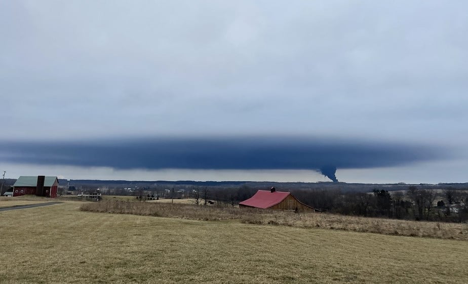
Photo is not a distant tornado in Ohio. It's the toxic plume
from the train derailment in East Palestine, Ohio mixing
with an overcast and then precipitating down in
a broad area during this environmental disaster. 
The huge environmental disaster from the train derailment in East Palestine, Ohio earlier this month was almost certainly created by human error. 

Weather conditions helped spread the mess. 

 We're lucky some of Ma Nature's extremes didn't make it even worse.  The weather during the disaster was pretty average, helping to contain the toxic mess to a relatively small area. 

Still, it's bad enough.  

The train derailed on February 3 in East Palestine, Ohio, very close to the Pennsylvania border.  The train cars were still burning on February 5 when emergency officials noticed a rapid temperature change in a derailed tanker car that contained vinyl chloride, a chemical used in the manufacture of PVC.

Vinyl chloride explodes violently when heated too much, so a catastrophic blast seemed imminent, according to Ohio officials. So they made a decision to do a controlled release of the chemical, which sent an immense black, toxic cloud of smoke and fumes skyward. 

What goes up must come down. We don't have good information on what kind of fallout came from that cloud.

We do know vinyl chloride is bad. Really bad.

 As the Washington Post reports: 

"'It is unclear how much of this volatile chemical escaped into the air or burned before entering surface waters and soil, but vinyl chloride is highly mobile in soils and water and can persist for years in groundwater,' said Cornell University soil and crop scientist Murray McBride, recommending that farmers test wells and surface soils in the months to come."

It seems pretty clear that there's a high risk to people right near the derailment site. What about people near the cloud released during the "controlled release?"

At the time of the "controlled release," around 3:30 p.m. February 5, winds in the area were from the west to southwest at 10 to 15 mph, according to weather data from nearby Youngstown, Ohio.

The day was overcast, and the release launched a plume of dense black smoke that rose up into the overcast, and spread out when it hit that cloud layer. Judging from photos, there might have been a temperature inversion that allowed the smoke and fumes to linger over the area, probably dropping fallout of some sort. 

I'm not sure how long this "controlled release" lasted, but in the following days, the winds kept changing directions. 

Breezes of 10 to 15 mph came from the northwest on February 6, for instance. On February 7, winds in the area were mostly from the south at 15 to 20 mph, but they shifted to the northwest later in the day.

This helped ensure whatever was in the air was dispersed in almost every conceivable direction.  

So far, the Environmental Protection Agency is saying that the area is relatively safe, though clearly more testing needs to be done. 

The air in and around East Palestine was reported to still have a chemical odor this week, but the EPA says you can smell the stuff and it would still be below unsafe levels. The following is my opinion, not from officials:

I'm not convinced its safe in and near East Palestine, or anyone who lives under or near that plume from the controlled release. 

People living in the area report dead fish in rivers. Chickens as far as 10 miles from the derailment site were found dead. 

 I have been asked by a couple people if there's any risk to us in Vermont from this Ohio environment disaster. The answer, thankfully is no. Even if the wind was blowing from the direction of the derailment, by the time the air got here, the plume would have been so completely dispersed that it would have no effect on us. 

This is the view above the cloud layer as a black plume
of smoke and toxins rise from the derailment disaster
site earlier this month in East Palestine, Ohio.

However, railroad tracks criss-cross Vermont and hazardous material is transported on these tracks. Unfortunately, there's every reason to believe another East Palestine could occur in Vermont. 

It doesn't help that train regulations are lax, and railroad employees are overworked, which can lead to errors. 

Much has been made of U.S. Transportation Secretary Pete Buttigieg's somewhat muted response to the East Palestine catastrophe. But - forgive me for injecting politics into this - more blame should go to the previous administration.

It's too soon to pin down the exact cause of the crash. However, the Obama administration in 2015 put new rules in places requiring  trains carrying flammable liquids to use electronically controlled pneumatic brakes. These would apply braking simultaneously across a train rather than railcar by railcar over a span of seconds. This rule would have taken effect this year.

But the Trump administration dropped those rules in 2017, saying they were too expensive for railroads.  

Since it feels like another train disaster is inevitable under current rules and practices, weather conditions will always be there to potential make these catastrophes worse. 

I don't think it's an "if" as to when we see another East Palestine. It's a "when."   

Tuesday, June 14, 2022

Another Derecho, This Time In Midwest, And Yellowstone Drowns

All those blue and black dots extending from Wisconsin
 to West Virginia represent storm damage reports from
an apparent derecho yesterday and last night. 
 Along the western, northern and eastern edges of big heat waves, you often see violent thunderstorms, the so called "Ring Of Fire" I talked about earlier this week. 

That is certainly the case with the current record heat wave gripping the middle and south of the nation. An apparent derecho formed yesterday afternoon, bringing winds gusts of up to 84 mph at Chicago's O'Hare Airport and a 98 mph gust to Fort Wayne, Indiana.

Meanwhile, out on the northwest edge of the heat, an unprecedented flood hit areas in and near Yellowstone National Park.

DERECHO

It's already been a bad year for derechos, which are defined as damaging and dangerous thunderstorm complexes that travel at least 240 miles, spreading destruction along the way. 

I don't think it's been officially declared yet, but it's apparent a derecho originated in southern Wisconsin Monday afternoon, then roared southeastward through the Chicago area, Indiana, Ohio and into West Virginia. 

NOAA's Storm Prediction Center logged 382 thunderstorm wind reports yesterday and last night, most of them in the Wisconsin to West Virginia swath. 

In Chicago, tornado sirens blared and echoed around downtown skyscrapers. No tornado is known so far to have touched down, but there was plenty of wind damage with those 84 mph gusts. Many cars and houses were damaged by falling trees. The roof of a three story apartment building peeled away. 

Travelers at O'Hare were ordered into below ground shelters or packed themselves into rest rooms, which double as tornado shelters. The air traffic control tower was evacuated, there was obviously a ground stop on all flights, so everything was and still is badly disrupted. Some planes had to be checked for hail damage before being allowed to fly. 

At least 44,000 people were without power. Some won't have their power back until after today. Record heat and humidity is forecast today in Chicago.

That 98 mph wind gust in Fort Wayne is the strongest ever recorded in that city. A SkyWest hangar near the airport was blown to pieces.  Extensive tree damage and widespread power outages continued on into Ohio and parts of West Virginia. All these areas are under the gun for record heat today. Many people will have to endure the heat without air conditioning. 

If last night's weather is confirmed as a derecho, it will already be the third destructive and deadly one to hit North America this year. On May 12, a derecho, accompanied by dust storms struck South Dakota and neighboring parts of Nebraska, Iowa and Minnesota, killing two people and causing widespread damage, including the South Dakota cities of Sioux Falls, Watertown and Brookings.

Another derecho in southern Ontario and Quebec hit the most populated section of Canada on May 21 causing at least ten deaths in towns near Toronto and Ottawa. 

Part of a house falls into a flooding river in Gardiner, Montana
Monday during unprecedented flooding in and near 
Yellowstone National Park. Photo by Steve Rupho via CNN

YELLOWSTONE FLOOD

On the northwest side of the heat wave, high temperatures rapidly melted mountain snows, and torrential thunderstorms swept through areas around Yellowstone.  The combination caused unprecedented flooding in rivers across northwestern Wyoming and parts of Montana.

Yellowstone National Park was completely shut down by the flooding. The torrents swept away bridges, collapsed roads, washed away or flooded cabins and homes and stranded an unknown number of tourists. 

Luckily, the rain there is tapering off and temperatures are cooling, but the damage is done.

VERMONT IMPACTS

The Green Mountain State continues to be one of the few areas in the nation with benign weather. We have gorgeous days today and tomorrow with sunshine, seasonably warm temperatures and low humidity.

Thursday looks a bit more humid, and we'll probably see some showers and thunderstorms later Thursday into Friday. But this still looks like it won't be anything extreme. Forecasts are also steady for an unusually cool weekend and early next week. 


Wednesday, February 16, 2022

Update: That Moronic Ohio Snow Plow Driver Has Been Fired

The snowplow driver, who, as seen here, was flinging
ice and heavy slush onto the opposite side of an Ohio
highway back on January 23, has been fired.
 It's always nice to get a little update and I have one here.

You might remember my post from late January in which a clueless Ohio snowplow driver on one late of a highway flung great quantities of ice and slush into the opposite lane, damaging at least 50 vehicles and injuring 12 people. 

He was suspended pending an investigation after that.  The update: To nobody's surprise, the idiot was fired.

The hapless driver, Timothy Rakay, 5,  received this letter, which read in part:

"Your employment is being terminated for an egregious Chargeable Accident on January 23, while engaging in grossly negligent behavior as to endanger life, property, public safety or otherwise cause the Commission to be liable for the damage."

I haven't found any response from Rakay in the news clips out of Cleveland.  The incident happened about halfway between Toledo and Cleveland after a four-inch snowstorm.   

Thursday, January 27, 2022

Nominee For World's Most Moronic Snow Plow Operator

Video still showing a clueless snow plow driver in Ohio 
blithely spraying chunks of ice and slush into 
the opposite lane of the Ohio Turnpike, damaging 50
cars and injuring 12 people. 
 I live on what is officially a Vermont State Highway, (Route 36) so trucks from the Vermont Agency of Transportation plow snow and spread salt on the road that runs in front of my house. 

I'm always impressed by how professionally and promptly clear the roads at all hours of the day. 

I'm also pretty sure highway crews in other states are just as good at their jobs.

But there's bad apples everywhere. Which takes us to the Ohio Turnpike in Erie County, Ohio. There, a clueless plow truck driver and moron decided to cause some havoc.

The stuff he was clearing from the westbound lanes of the Ohio Turnpike consisted of heavy slush and chunks of ice.  The driver could have arranged the plow to push the slush off the right side of the highway, or at least go slow enough so the ice wouldn't go all over the place if he wanted to clear it in the opposite direction.

Instead, the oblivious idiot went fast enough to propel the slush and ice over a median barrier and onto traffic in the eastbound lanes of the Turnpike. For two whole miles at least.  

He did this without seeming to notice he was wrecking car after car and causing a number of accidents. By the time Moron Plow Driver was done, at least 50 cars were damaged and 12 people had injuries. Luckily, none of the injuries were life threatening.

Which is a miracle. Video of the incident showed numerous tractor trailers on the highway, which could have lost control during the incident and flattened smaller cars.

News video, which includes a video of the slush and ice being dumped on the highway and smashing into cars and causing crashes, is at the bottom of this post. 

Needless to say, the motorist affected are wicked pissed. People were stranded without cars.  Owners of damaged cars were told to file a police repot and the the Ohio Turnpike and Infrastructure Commission would deal with insurance claims.

But other than that, everybody was on their own. One woman from Youngstown with a damage car was just dumped at a local McDonald's and told to figure out on her own how to get home. 

The Commission put the Moron Plow Driver on administrative leave pending an investigation. They also did some drug and alcohol checks on the guy.

The Ohio Turnpike and Infrastructure Commission statement, included in this news report, is a triumph of vacuous PR damage control attempts, but it's so florid that whoever wrote it was really desperate.

They smell the lawsuits coming.

I don't mean to disparage that whole commission, as I'm sure most of them are cool and know what they're doing. But yikes!

By the way, the vast majority of crashes involving snow plows are not the fault of the snow plow drivers.  Seems like other motorists can't seem to avoid smashing into what we would think are highly visible, big trucks with flashing lights. But what to I know?   

Despite my high confidence in Vermont snow plow drivers, I'm going to be more than a bit careful when I see the plow's wave of snow coming my way. 

Here's the news video that includes the images of the plow spray that snow and slush. The video report says 40 cars were damaged but that was later updated to 50 or so.   Either click on this hyperlink, or view below: