Showing posts with label Wisconsin. Show all posts

Monday, August 11, 2025

Milwaukee Latest Target In Summer Of Flash Floods

Car roofs barely visible in Milwaukee,
Wisconsin late Saturday night/early
Sunday morning as that region became
the latest victim of an epic summer'
of flash floods in the U.S. 
 Milwaukee, Wisconsin was the latest city over the weekend to drown in extreme rains in a summer that has brought a series of record-busting floods.    

More than a foot of rain was reported in some areas near Milwaukee Saturday night and early Sunday.   

One section of Milwaukee reported an incredible 14.49 inches of rain.  If confirmed by the National Weather Service, that would set a new 24 hour rainfall record for the entire state of Wisconsin. (The current record is 11.92 inches in Mellon, Wisconsin back in 1946.) 

The National Weather Service office at the airport roughly six miles south of downtown Milwaukee reported 6.69 inches.  Two inches of that fell within an hour. 

As in many flash floods of this type, the rainfall was highly localized. Mount Pleasant, just 30 miles south of Milwaukee, reported just over an inch of rain, with no trouble there. 

Since the heaviest rain targeted a large urban area, the trouble escalated almost immediately late Saturday night. Hundreds of basements suddenly flooded, dozens of streets and roads became instant rivers.  The Milwaukee River at Estabrook Park reached a record crest of 10.52 feet.

Residents described their cars suddenly submerged, and water cascading through trim, doorframes and vents, filling houses knee deep or worse. As you might imagine, the damage is severe, especially since so many homes and businesses took on water. 

 The storms forced the early closure of the Wisconsin State Fair Saturday night. Its final day on Sunday did not open because of the flooding, notes Wisconsin Public Radio.

The USA Triathlon canceled its Sprint National Championships and Paratriathlon National Championships Sunday due to flooding and damage to the courses.

The Milwaukee Mitchell International Airport temporarily shut down due to flooded runways, taxiways and an underpass tunnel.

Milwaukee and several surrounding communities were under states of emergency Sunday. The city's dispatch center received over 500 calls regarding flooded basements, inundated roads and stuck cars. 

Across Milwaukee, and in nearby suburbs like Wauwatosa,  people were rescued from homes by boat.

So far, no deaths or serious injuries have been reported from Milwaukee.

The Milwaukee flood was part of the same system that also caused 80 mph winds in Nebraska that led to at least one death. 

Separately, wild downpours this weekend dumped 11 inches of rain around Sanibel Island and St. James City, Florida over the weekend, causing serious flash flooding there. 

The Milwaukee storm was one of a serious of extreme flash floods that have hit various parts of the nation this summer. 

The most notable, of course, was the extreme floods that hit the Hill Country of Texas on the Fourth of July weekend, killing 136 people.

Other exceptional floods hit places like Ruidoso, New Mexico, parts of New Jersey, Illinois, Oklahoma and other states this summer. 

Flash flooding is a risk every summer, but some of these floods have gotten more extreme and more frequent. 

Climate change allows the atmosphere to hold more moisture than the cooler global air we had decades ago.  If the right storm comes along, that added atmospheric water unleashes itself in torrential downpours, causing floods much bigger than what would have been expected, say, a century ago.  

Monday, April 28, 2025

Severe Weather/Tornado Outbreak Upper Midwest Today, We In Vermont Could See Severe Storms Later Tuesday

Widespread severe storms and likely tornadoes are 
likely today, especially in red and orange areas 
on this map. 
The Upper Midwest if bracing for a rough day today of potentially strong tornadoes, giant hail and destructive winds as the weather set up is almost ideal for a severe weather outbreak in that neck of the woods. 

That severe weather is forecast to some extent migrate toward the Northeast, maybe affecting Vermont later tomorrow. More on that in a bit. First, today's Midwest threats.

TORNADO RISK DETAILS

Even before our storm really got going, things were looking ominous Sunday evening. Some supercells spit out a handful of large tornadoes in western and central Nebraska.

Some pretty strong storms were ongoing early this morning in eastern South Dakota and southwest Minnesota.

These are just a preview. The main show will get going this afternoon

The area under the biggest threat for dangerous weather today includes most of Wisconsin and Iowa, southern and central Minnesota and northwest Illinois.  

Major cities most likely to be under the gun are Minneapolis-St. Paul, Minnesota; Madison, Wisconsin; Des Moines, Iowa and Rockford, Illinois.

A somewhat lesser but real threat extends southwestward all the way down to Texas.  

We know we'll see severe storms and tornadoes in the Upper Midwest today, but we don't 100 percent know exactly how they'll evolve.

If supercells manage to form and maintain themselves ahead of the main line of storms later today, then we end up with the risk of strong, long-lasting tornadoes plowing through Iowa, southeastern Minnesota and Wisconsin. 

That scenario is a maybe/maybe not. But if these dangerous supercells erupt, they'll go from nothingburgers to extremely dangerous monsters in minutes. The National Weather Service office in the Minneapolis area is not mincing words in their forecast discussion:

"The takeaway from today's severe storm potential is to remain vigilant of the potential for storms to go up quickly. This may mean checking your phone more often or keeping an eye to the sky, but don't let your guard down in this environment."

 If, instead, the main line of storms exerts itself more, there might not necessarily be those supercells out ahead of the storm  This second scenario is still bad news, as there will be zones of destructive straight line winds and quite a few embedded tornadoes in this mess.

The most likely outcome  today is a combination of what I described above. The main question will be how many supercells form ahead of the main blast of storms. 

TUESDAY'S STORM ADVANCE

Tuesday's severe storm risk area is in yellow, with the
orange area at a somewhat higher risk. Note how the
yellow risk area extends into parts of Vermont, 
By Tuesday, the main threat from this dynamic storm heads east. The storm center itself will race up into central Quebec, but its powerful cold front will press east into the Great Lakes. 

Tuesday's threat area runs from southern Quebec and Ontario, then southwestward through northwest New England, the eastern Great Lakes, northern Ohio Valley then all the way down to central Texas. 

The greatest threat looks go from central Ohio, through northwest Pennsylvania and on into western and central New York.  

While there might be a couple tornadoes in this area, the main threat is damaging winds and large, destructive hail.

As noted, the severe threat extend into Quebec and northwest New England, so that puts Vermont in play. Details next:

VERMONT THREAT

This daffodil looks completely defeated and possibly 
dead after Sunday's snow in St. Albans, but....
Before we get into the severe storm threat, a final word or two on Sunday's snow.

A couple places got an impressive amount of snow. A high elevation spot in Greensboro reported .1 inches of snow. Brownington reported 3.5 inches.  

Here in St. Albans, it was striking how snowy and miserable it was in the early afternoon.

 By evening, it was a downright pleasant spring evening, with sunshine and relatively mild air. Go figure.

Today, by the way, will be gorgeous, with sunshine and temperatures in the 60s to near 70. Enjoy!

Now onto our next threat. 

But same daffodil three hours after above photo was taken
shows a nice recovery. This daffodil, and the rest of
them in the gardens, might have to endure some
severe thunderstorms Tuesday evening in northwest Vermont.
South winds ahead of that approaching cold front will throw a squirt of warm, somewhat humid air into Vermont. 

 Most of the day will actually be nice with highs reaching well into the 70s, with maybe an 80 degree reading or two in a couple of Vermont's more "tropical" towns. 

Dew points - a measure of how humid it will get - should reach the mid 50s to around 60. That's kinda humid for this time of year but not oppressive. 

Thunderstorms thrive on humid air, so the more muggy the air is, the more fuel for these storms. 

So the outlook for the thunderstorms in the humidity category is so-so.  

However, there will be strong winds aloft. Storms that do form can grab that high altitude air and shove it down to the surface, where we are. That's why there's the risk of severe storms.  A few of these could have wind gusts to 60 mph or even a little more. 

The heat from sunshine created instability, which is part of the reason why the thunderstorms are likely to be so strong over New York, since they'll hit there in the afternoon.

Timing is such that the storms look like they'll come in very late in the afternoon and evening. For instance, current forecasts have the best chance for thunderstorms in Burlington between 6 and 8 p.m. Tuesday,

By the time they reach Vermont, the storms will be beginning to diminish. At this point, it looks like a few storms still might have enough oomph to be severe generally in an area north and west of a line running from roughly Rutland to Montpelier to east of Newport. 

As the storms head toward southeastern Vermont later in the evening they'll diminish to nothing scary. 

Note that not everyone will get a severe storm. Northwest Vermont is in a level two of a five point risk scale, five being the hair-on-fire top scary alert. Our level two "slight risk" means scattered severe storms are possible, but they'll tend to be relatively short-lived and not terribly widespread.

So, just keep your eye to the sky Tuesday evening if you're in northwest Vermont and head inside if you receive a severe thunderstorm warning or see ominous skies to the west and north. 

The cold front might also produce some fairly strong winds after the thunderstorms go by.  These winds won't be associated with any thunderstorms, but they could cause very isolated power outages in a  few spots.

Unlike the cold front we saw this past weekend, it won't get nearly cold enough for snow.  Instead, Wednesday looks bright, refreshingly cool and breezy.  

Saturday, November 30, 2024

A Factory-Effect Snowstorm? Yeah, It Really Happened.

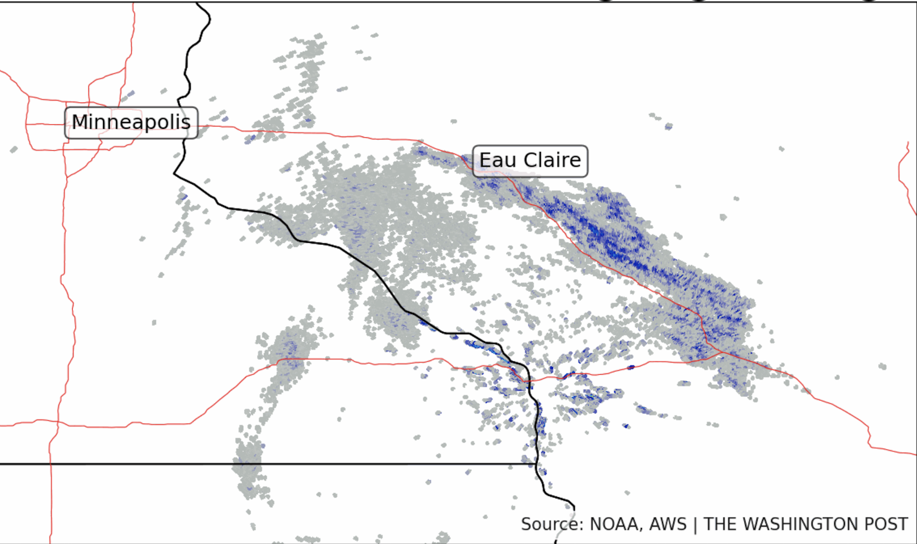
Radar imagery from Thanksgiving shows a 100-mile
long band of snow along Interstate 94 in Wisconsin
caused by, of all things,  factory.
Lake effect snowstorms are in the news this weekend. 

But here's an odd one: 

A factory-effect snowstorm shut down part of an Interstate highway in Wisconsin. That's right, a factory caused a snowstorm.

As the Washington Post describes it, a glass factory near Menomonie Wisconsin spewed steam and a few particles into the air on Thanksgiving, like it pretty much always does.

It was a dull Wisconsin morning, cold, damp, with a low overcast. Temperatures were in the 20s, and it was much colder than that a few thousand feet up.

The low stratus deck consisted of zillions of supercooled water droplets. 

Supercooled water droplets are at a temperature below freezing, but are still liquid. Those supercooled droplets will freeze if something hits them, like particles in the air or ice crystals.

The steam belching from the glass factory did the trick. As soon as the emissions hit that supercooled low overcast, the droplets froze and changed into snowflakes. Which fell out of the sky. In droves.

It was obviously only a very narrow band, as just one set of factory smokestacks can do so much. But the snow band pretty much paralleled Interstate 94 win Wisconsin for up to 100 miles. 

Hard to see due to thick snow falling, but traffic tie
ups on Interstate 94 in Wisconsin Thursday caused
by a weird factory-effect snowstorm. 

The variable visibility and slick pavement created by the snow caused some crashes which temporarily closed part of the Interstate.  There were reports of 16 crashes within five hours, including a six-car pileup. 

Snowfall amounts were fairly modest, as again, a factory isn't a lake and doesn't have the power to produce feet of snow like Lakes Erie and Ontario can in western New York. 

Still a good three inches of snow fell along some of the path of this factory-effect snow, so that's pretty impressive. 

This isn't the first time something like this happened but it's one of the more impressive. Emissions from power plants and even steam from relatively small rivers can create snow. Sometimes, it doesn't take much to make it snow. 


Monday, May 13, 2024

It's Ba-a-ck! Canadian Wildfire Smoke Making Inroads (*Not In Vermont Yet)

A thick, smoky haze engulfed St. Albans on June 25, 2023
as winds blew wildfire smoke southward from Canada.
Fires are starting in Canada again, and we might have
another smoky summer like last year as a result. 
 Air quality alerts were in effect in much of Minnesota and Wisconsin this morning as wildfire smoke from Canada drifted into the two states behind a cold front. 

So yes, last year's acrid "gifts" from Canada are back. 

Fires are burning in British Columbia and Alberta, generating smoke that's spreading across much of central Canada and dipping down into the north-central United States.     

The fires near Fort Nelson, in northeastern British Columbia forced the evacuation of 3,500 people.

A wildfire near Fort McMurray, an oil hub in northeastern Alberta put residents there on alert for possible evacuations. 

That had to make the 66,000 residents there especially antsy, with memories still fresh of the 2016 calamity there. In May, 2016, a massive wildfire roared through Fort McMurray, killing two people and destroying 2,400 homes and businesses. The blaze was the most expensive disaster in Canadian history. 

This weekend, a few well-timed showers helped temporarily tamp down the fire near Fort McMurray. More showers are in the forecast and shifting winds are driving flames away from the city for now.   

The fires, though widespread in Canada, are is far not as extensive as they were this time last year. Which means there's not quite as much smoke being generated.  In turn, that means the big smoke outs we had last year in the United States aren't repeating. At least not yet. 

LOOKING AHEAD

There's plenty of time for wildfires to grow, as they can last all summer and into the autumn. 

We also have some ominous signs for wildfires this summer in Canada.

Last month, Canada's government warned of a potentially explosive fire season, citing drought in parts of British Columbia, Alberta and Ontario. Additionally, unseasonably warm temperatures melted snow prematurely, allowing the landscape to dry out earlier and faster and more completely than it otherwise would.

The same thing happened last year, when 37 million acres of Canadian forest burned. That was easily the worst fire season in the nation's history.  

Another wildcard is "zombie fires." Those are fires from last summer that spend the winter smoldering underground all winter. 

If hot dry weather hits, those zombies could come back to life, causing new big, destructive wildfires. There's evidence that's starting to happen in Alberta. 

CLIMATE CHANGE ROLE

Canadian government officials say climate change has made wildfires more likely in Canada than they once were. 

I also need to detour into a bit of a rant here.

Climate change denial types are all over social media, thinking they have a winning argument.  They're mocking a non-existent notion that "leftists" think climate change causes wildfires.   As if those worried about climate change think forests just spontaneously burst into flames if it gets too hot out. 

To be clear, nobody thinks climate change "causes" fires.  Lightning, downed power lines, arson and stupid people are major causes. The problem is climate change often makes those fires worse than they otherwise would be.

If climate change makes things hotter and drier, the fires will more likely get out of control and spread more widely. Climate change can turn nothing burger local blazes into widespread, dangerous conflagrations. 

VERMONT OUTLOOK

So far, unlike last year, there are few if any fires in Quebec and other eastern Canadian provinces.  If that trend continues, we in Vermont are less likely to see dense smoke like we did last year.  Instead, the western Canadian fires will probably occasionally make our skies hazy, but the pollution in general might not be as bad as last year. 

All bets are off, though, if Quebec and Ontario burst into flames like last year.  Could happen this summer. 

As for that smoke currently in the upper Midwest, forecasts don't bring much of it our way once that cold front makes its way through New England during the middle of the week. We might see a bit of haze in the sky, but I don't anticipate a big smoke attack.