Showing posts with label Northeast Kingdom. Show all posts

Friday, April 24, 2026

Spring Rains Easing Lingering Vermont Drought: A Dry Week Will End In A Wet Spell

All winter and early spring, the U.S Drought
Monitor showed continues moderate drought
in northeast Vermont, (orange) and 
abnormal dryness south (yellow)......
Lingering drought in Vermont was literally frozen in place all winter. 

The very serious drought the state experienced last summer and fall had eased somewhat thanks to decent rains in the late autumn. 

Severe drought in northeastern Vermont improved to moderate drought as we went through December, according to the U.S. Drought Monitor. But then the improvement stopped. 

The northeastern third of the state remained in moderate drought, and southern Vermont was abnormally dry through the winter and early spring. 

Rivers, lakes and the ground had frozen as we'd gotten deeper into winter. Most of the precipitation fell as snow. Snow is only potential drought relief. It doesn't really help anything unless it melts.  The question remained: Was the drought continuing to est. 

The thawing of spring has cleared that up. The dry conditions are improving. 

We didn't actually see any change in the weekly drought reports until the April 16 weekly report. Drought had been reduced to a small area in the Connecticut River valley. The Northeast Kingdom and southern Vermont were still abnormally dry, but not quite in drought. 

This week's U.S. Drought Monitor report, released yesterday, shows just a sliver of the Connecticut River Valley between about White River Junction and Springfield still in drought. That area represents only about 4% of Vermont's land area were still in drought. 

Most of the rest of southern Vermont was still abnormally dry, but that designation was removed in the Northeast Kingdom. The drought in northern parts of the Green Mountain State that began last August  is finally over, at least for now. 

The measurements the U.S. Drought Monitor uses go up to Tuesday, two days before the report is released. 

This week's U.S. Drought Monitor, released
yesterday. has only a small area of drought
near White River Junction and Springfield
and abnormal dryness in southern
Vermont. Elsewhere the trough is over. 

This week, Vermont has entered a notable dry spell. Nothing other than isolated sprinkles and a few snowflakes have fallen since this past Tuesday. 

No rain is forecast until at least next Tuesday. The air will remain very dry over the next few days, with rock-bottom humidity levels. Strong April sun will penetrate to the ground through still-leafless trees. 

That means we might  have a little backsliding in next week's U.S. Drought Monitor report, but I wouldn't worry too much.

Week-long spells of very dry weather are common in late April and early May. It doesn't mean they will last that long. 

In fact, forecasters have relatively high confidence that we'll enter a wetter period starting in about five days or so. I don't' see boatloads of rain coming,

Most of the time over the next couple of weeks, we won't have any actual storms bringing steadier rain to the North Country. We'll probably have a couple such storms, but they won't represent the majority of the weather we'll face.

Instead, a pool of very cold, subfreezing air will settle in several thousand feet overhead. In the winter, that would have meant a long, miserable slog of overcast skies and light snow flurries.

This time of year, with the strong spring sun, that means the cold air aloft will create tall, billowing clouds.  That means frequent showers, especially in the afternoons and evenings, mixed with a few breaks of clouds. We might well get into an early May pattern where it rains every day or close to it, but very few days would be a washout. 

We'll have to wait a few days to see if the weather will work out exactly that way. We'll also have to wait until next week to determine which days turn out mostly wet, and which turn out mostly dry with just a few showers. 

SPECIFIC VERMONT FORECAST

In the meantime, sunshine is the name of the game.

Here are some specifics

Today/Saturday

Today will be the coolest day of the bunch. Most of us had a frost and freeze this morning. No worries, we always get those this time of year and it wasn't enough to harm garden plants. 

Highs this afternoon will only get to the upper 40s in the Northeast Kingdom to the low 50s elsewhere. There should be some mid-50s on southern valley floors. 

It will feel a little confusing out there, just as it did yesterday. When there's a lull in the wind, it will feel warm and you'll wonder why you're wearing that damn fleece.  Then a little gust of wind will come along and you'll know why. 

Tonight will actually be a little colder than last night. Almost everyone will get into the mid and upper 20s. It might be closer to 30 in the warmer valleys. 

Such temperatures would be a big problem in mid-May when everything is blooming. But the early stuff out there now should do just fine. 

The storm that caused the tornadoes and rough weather in the Plains Thursday is shearing apart. The remains of the storm will create an area of rain that will dive down from basically Buffalo, New York, to New York, City on Saturday. 

That will leave us in the clear, with maybe some high clouds, especially in southwestern Vermont.  It'll be a few degrees warmer than today, but still just a touch on the cool side. 

Sunday/Monday

The sunshine fest will continue, as highs top out near 60 degrees both days. That's roughly normal for this time of year. Yes, 60 is normal. We're in full spring now. 

Tuesday and Beyond

We might squeak out one more sunny day Tuesday. It depends on the pace of a weakening storm that will be headed our way. After that, the showery regime I mentioned should settle in for awhile. 


Saturday, October 25, 2025

Trump Denies Disaster Assistance To Blue States, Including Vermont; Send Money To Red States

Damage in Sutton, Vermont after flooding this July. 
President Donald Trump rejected a disaster declaration
for the Northeast Kingdom, likely over politics.
 We've got some more likely evidence that everything Donald Trump does is transactional. And some of the latest news involves us here in Vermont.  

Here's the news, straight from the Associated Press:

"President Donald Trump approved major disaster declarations for Alaska, Nebraska, North Dakota and the Leech Lake Band of Ojibwa late Wednesday, while denying requests from Vermont, Illinois and Maryland and leaving other states still waiting for answers.

The decisions fell mostly along party lines, with Trump touting on social media Wednesday that he had 'won big' in Alaska in the last three presidential elections and that it was his 'honor' to deliver to the 'incredible Patriots' of Missouri, a state he also won three times."

Trump just cannot keep his mouth shut. 

If he hadn't bragged like he always does, he'd have plausible deniability about him picking favorites.  

Trump has approved more disaster declarations than he's thrown away. But he keeps talking about phasing out FEMA, saying he wants states to take the lead in disasters, 

The Vermont piece of this was for July 10 flash flooding in the Northeast Kingdom. State officials waited more than nine weeks for Trump's negative decision. Damages far exceed what some of the affected little towns up there in the NEK can afford, said Eric Forand, the Vermont Emergency Management Director. 

The flood caused more than $1 million just in the town of Sutton, which has a population of only around 200. Across Vermont the July 10 storm caused almost $2 million in damage. The minimum threshold to qualify for federal aid should have been $1.2 million, reports WPTZ.

Vermont Gov. Phil Scott said his administration won't appeal the decision. "When submitting the request we knew that there was a chance it could be denied - and we do not plan to appeal the decision... Moving forward, we'll explore ways to support rural communities with limited resources and what assistance could look like."

Scott is a Republican, but a moderate who, unlike most members of the GOP, has expressed no fealty to Trump and criticizes him at times. Vermont is also known to be among the bluest of blue states. 

In recent public opinion polls, Vermont ranks second behind Hawaii as the least supportive of Trump. Only 24 percent of Vermonters approve of Trump versus 72 percent who oppose him. 

In deciding not to appeal, Scott probably looked at Maryland as an example of what could happen if he did go ahead with asking again. 

Maryland, also a decisively blue state, requested a disaster declaration for two counties in the western part of the state that suffered significant flooding. In July, Maryland requested a disaster declaration, but Trump turned it town. Maryland appealed that decision, because the counties suffered $33.7 million in damage, three times its threshold for federal assistance, reports the AP.

Trump this week turned down that appeal. 

"President Trump and his administration have politicized disaster relief, and our communities are the ones who pay the price," said Maryland Gov. Wes Moore, a Democrat.

White House officials are trying to portray the denials as heroic efforts to save taxpayers money and mot the partisan attacks that the probably are.

"President Trump provides a more thorough review of disaster declaration requests than any Administration before him," said White House spokesperson Abigail Jackson. 

Yeah, right. 

But she went on, saying Trump was "ensuring American tax dollars are uses appropriately and efficiently by the states to supplement - not substitute, their obligation to respond to and recover from disasters."

Sure, because the tiny town of Sutton, Vermont  has a million dollars lying around their town offices to fix the flood damage. 

By the way, I can't begrudge anybody who did receive disaster assistance. They need it. Particularly in western Alaska, which was hit earlier this month by a record strong former typhoon that produced a destructive and deadly storm surge. 

But if you live in a blue state, and you're hit with a hurricane, tornado, wildfire, flood or something dramatic like that, remember that Trump wants you to use those experiences to love him, or else.

Like that's going to happen. 

I'll have a separate piece coming up about how the federal government is shortchanging major disaster zones like western North Carolina, which was devastated by Hurricane Helene last year.  

Friday, July 11, 2025

Latest Vermont Flood: Details Emerge As Questions Grow About FEMA

Map of rainfall yesterday in Vermont, from data 
collected by the National Weather Service in 
South Burlington. Heavy rains were confined
to parts of the Northeast Kingdom, and a 
couple spotty areas in central Vermont. 
For the third year in a row, some Vermonters are picking up the pieces today after yet another flash flood. 

The tiny town of Northeast Kingdom town of Sutton, population of less than 1,000, appears to be the hardest hit. The good news is that so far, I haven't heard of any serious injuries with this latest flood. 

But the damage was also scattered around the state. A large section of the Middlebury Union High School roof was torn off by intense thunderstorm winds on Thursday. The roof damage allowed some of torrential rains with the storm pour into the boy's locker room, cafeteria and auditorium. 

Officials at the school said the interior damage was thankfully not severe. 

Flood damage was still being tallied in West Burke, East Haven and other Northeast Kingdom towns, along with some spots in Addison County.  But Sutton took the brunt of it. Video from Live Storms Media showed water racing across a road near Sutton, forming a waterfall on one side where the road had washed away. 

 Vermont Public reports that the swift water rescue in Sutton involved a couple and their dog, who were pulled off their roof by the rescue group during the flood. 

Rainfall was highly variable and highly localized. Only a few places received torrents of rain. Many  Vermont towns received little or no rain yesterday. 

The disparity was evident even within the counties hit hardest. West Burke in Caledonia County reported 5.12 inches of rain. But in the opposite end of the county, Wells River and Barton saw only 0.04 inches.  

This is a map of rainfall in the July, 2023 flood. As you
can see here, that one affected pretty much the whole
state, not just a few areas. Pink and purple areas had
at least five inches of rain. Compared to yesterday,
July 23 was many times worse. 
Slow moving thunderstorms parking over certain towns were to blame. Disconcertingly, that same issue of stalled downpours has arisen today. But the storms are very few and far between, and smaller in size than yesterday's.   

If any new flash flooding develops late this afternoon or this evening, it will be highly isolated. However, we're still looking at low but not zero chances of isolated flash flooding Saturday, Sunday and Monday. 

That the chances of new flooding are - fingers crossed - low is good news, as some towns already have a ton of damage. 

Further details from Vermont Public:

"Roughly 20 homes in the Caledonia County town remained cut off from road access as of Friday morning, according to the town fire chief. Town officials said they've made contact with most of these homeowners, but expect it will take several days to make these roads passable.

The storm overwhelmed many of Sutton's roads, culverts and ditches and damaged several homes along Calendar Brook Road. 

According to initial estimates, repairs to the town infrastructure could cost upward of a million dollars - after Sutton has already spent millions on recovery from previous floods."

I don't think anybody knows where Sutton - and other affected towns in the Northeast Kingdom will get the money to fix damage from the latest calamity. 

This is especially true with the Federal Emergency Management Agency's future in doubt. 

FEMA AND VERMONT

We won't know for awhile yet whether the damage in Vermont would qualify for federal assistance even under the "old rules" for federal assistance that were in effect before Donald Trump took office in January. 

Even if Vermont qualifies for help under those old rules, who knows whether we'll receive it? Everything Trumpian is subject to his whims, and information and plans shift like the breeze.

Trump has said he wants to abolish FEMA. Or change it. Or shift all the responsibility to the states. 

Today, as Trump headed to Texas to survey damage from a deadly Fourth of July flood that was many, many orders of magnitude worse than what Vermont saw, his administration's previous vows to abolish FEMA are wavering. 

Per today's Washington Post:

"A senior White House official told the Washington Post that no official action is being taken to wind down FEMA, and that changes in the agency will probably amount to a 'rebranding' that will emphasize state leaders' roles in disaster response."

In other words, nobody has a clue what will happen. 

Which is the question everybody including Vermonters who would deal with disasters are asking. .  

Per Vermont Public: 

"State and national experts say only one thing is clear as of now: The new federal administration wants states to assume a bigger role in disaster response and recovery. The ambiguity over what that looks like, according to Eric Forand, director of Vermont Emergency Management, has complicated the business of disaster preparedness for state officials trying to gird for the next catastrophe."

Given Vermont's track record, this is really an important question.

Vermont Public had an eye-opening stat: 

"Vermont, which has experienced 25 federal disaster declarations since 2011, has been particularly reliant on federal aid. According to a recent analysis, the state has received more federal disaster assistance per capita over the past 14 years than any states but Louisiana, Hawaii, and New York."

There's no reason to think that trend will stop. Vermont is a flood-prone state. Climate change will continue to intensify storms, so more big floods are inevitable. We've already had two damaging flash floods this year, and we're only now getting into the peak of what you might call peak flash flood season.

Those humid July and August dog days can really produce those downpours. More so with climate change. 

 The theoretical solution for this entire mess is for the state, and disaster-prone towns to build up a rainy day fun to deal with inevitable future disasters. 

Good luck with that. The floods of 2023 and 2024 cost several individual towns more money than their entire annual budget. I'm pretty sure local taxpayers can't hand over twice the amount or more they've been paying already. 

We're lucky yesterday wasn't as bad as it could have been.

But still, we're screwed. 


For 3rd July 10 In A Row, Vermont Suffers Through Damaging Floods, More Trouble Ahead?

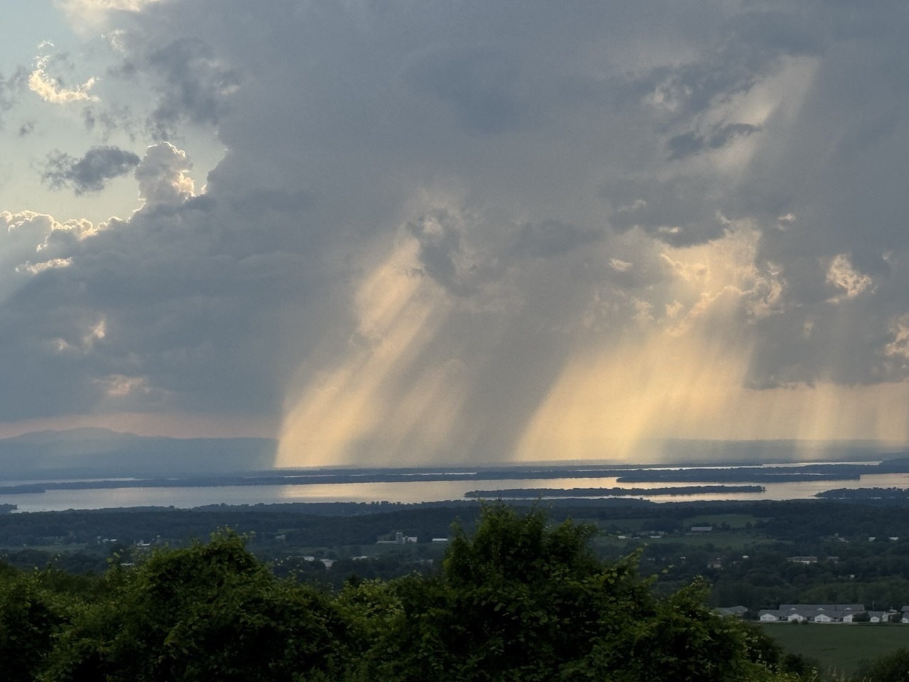
Thunderstorms developing near Lake Champlain 
caused falling rain and sunshine to mix in
interesting patterns, as seen from St. Albans, Vermont
Thursday. Though this storm was picturesque,
other storms elsewhere in Vermont caused a lot
of flood damage for the third July 10 in a row. 
 Yes, incredibly, as you might have already heard, for the third July 10 in a row, Vermont suffered through damaging flooding. 

The worst of the trouble this time was up in the Northeast Kingdom, with reports of water in homes, swift water rescue teams rushing a respond, roads closed, and four to five inches of rain in spots. 

Other flooding was reported in parts of Addison County. 

At least one swift water rescue was reported along Calendar Brook Road in Sutton.  They were there to "assist the residents of one  home cut off by floodwater," according to a Vermont Emergency Management statement, as VTDigger reported. 

Other rescue teams were staged around the state just in case. 

Barton and Orleans, and other Northeast Kingdoms communities have now suffered flood damage for the third July 10 in a row. That has to be incredibly disheartening. 

Damage reports from Thursday were a dime a dozen.  Sheffield Road was washed out in Sutton. School Street in West Burke was under water. Route 114 was closed due to a culvert washout in East Haven. Part of Route 58 in Orleans was washed out.

A number of local town roads in the Northeast Kingdom were either damaged or closed or both by washouts and flooding. 

Rainfall amounts in parts of the Northeast Kingdom were impressive to say the least. West Burke reported 5.07 inches, Sutton saw 4.92 inches. Down in Addison County, 4.32 inches fell in New Haven, where at least one road was closed by flooding. 

The storms this time were hit and miss. Parts of northwest and southern Vermont saw almost no rain. Burlington reported just 0.02 inches. Montpelier reported a tame 0.26 inches, which had to be a relief compared to the more than six inches of rain Montpelier endured on July 10-11, 2023, and the more than three inches they had last year. 

 If you want to find a weak silver lining from yesterday, I suppose the trend line is good. Thursday's floods weren't as widespread as last year's. And the floods of 2023 were even worse than in 2024. 

Almost all the damage from yesterday was in limited to the Northeast Kingdom and parts of Addison County. Last year's floods affected most of northern Vermont. The July, 2023 floods affected almost the entire state. 

So each July 10 is better, maybe?

That's cold comfort to anyone who suffered damage yesterday. It was especially distressing to have another July 10 in which the weather radio was crackling with an onslaught of flood and severe storm warnings. 

Still, another bright side was that some towns and cities that were hard hit in 2023 and 2024 like Barre, Montpelier and Johnson, reported little damage from Thursday's storms.  

Severe thunderstorms with powerful winds also roamed parts of the state Thursday. The roof of Middlbury High School was damage by powerful storm winds. Multiple trees crashed to the ground and blocked parts of Route 125 in Middlebury and Weybridge, along with Route 17 in Weybridge. 

Some tree damage was reported in Williamstown and Hyde Park

I don't know whether Thursday's damage qualified Vermont for federal disaster aid. Complicating the picture is the Trump administration is famously withholding disaster funds.  

The flood and storm reports from yesterday are still coming in, so I'll update as warranted throughout this. 

HEAT AND STORMS TO CONTINUE

Much like in the aftermath of the floods of July 2023, and 2024, Vermont is now settling into a weather pattern featuring hot, humid weather accompanied by some risk of additional damaging storms. 

NOAA's Weather Prediction Center, keeps Vermont (and many other parts of the nation) in a marginal risk for more flash flooding Saturday, Sunday and Monday. That's the least dire of four tiers of flood risk, meaning there's a chance of isolated flash floods.

On Saturday, there's only going to be scattered storms here and there, mostly just because the air mass will be warm and humid. At this point I think Saturday's the lowest risk day, and chances are good we'll get through the day with no trouble.

Forecasters are watching the period from Sunday evening into Monday. The air will be very humid, and a weather front will be approaching from the west. (Some are calling it a cold front, but there's nothing cold about it). 

We could see a few scattered instances of downpours heavy enough to cause some localized new flood issues.  Again, nothing widespread, but something to keep an eye on.

Behind this "cold front" on Monday, the air will stay very warm and humid, so that thing is going to be just a thunderstorm trigger and pretty much nothing else. 

A heat ridge will build in the eastern U.S. next week, ensuring Vermont will stay very warm and humid probably at least until the end of next week. 

Check out these forecast daily highs in Burlington Saturday, through Thursday: 87, 89, 85, 90, 92, 92. So yeah, icky,

Vermont will also be near the northern edge of that heat dome. Clusters of thunderstorms often ride along the northern edge of these things. We'll need to be on guard for the risk of perhaps some severe storms or local flash floods again most of next week. 

We don't know for sure about that. If we're lucky, everything will go by to our north. We'll have better forecasts once we get into next week. 

Saturday, September 28, 2024

Biden Grants Disaster Approval For Vermont NEK Floods On July 30; FEMA Money In Question

President Biden just declared three Northeast Kingdom
counties disaster zones due to intense flash flooding
back on July 30.  This frees up assistance funds, but
that money might be slow in coming due to
federal funding shortfalls and delays. 
In a widely expected move,  President Joe Biden has declared three Vermont counties disaster areas due to catastrophic flooding in the Northeast Kingdom back on July 30.  

It seems like every time we turn around, part of Vermont is declared a disaster zone. 

This declaration involves Caledonia, Essex and Orleans counties affected by a rather localized but intense storm on the night of July 30. 

The overnight storm dumped over eight inches of rain on St. Johnsbury and surrounding areas in just a few hours, causing catastrophic flooding. 

This declaration, like the other ones declared this year in other parts of the state, means federal grants and low cost loans are becoming available to fix homes and businesses. 

Local municipalities, and the state government, along with some non-profit outfits might also get some funds on a cost-sharing basis to repair or replace damaged roads and other infrastructure. That money can also be used to build some mitigation projects to help fend off future disasters. 

Earlier this summer Lamoille County was declared a disaster area due to flash flooding and severe storms on June 23.  And of course seven Vermont counties were declare disaster zones due to July 10 and 11 flooding. 

NO FEMA MONEY?

The money for this newest disaster declaration - along with those two other declared for summer flooding in Vermont - might be slow in coming. 

Congress just passed - and Biden just signed - a bill for stopgap federal funding to keep the government lights on through December 20.  That prevented a partial government shutdown. 

The Federal Emergency Management Agency, or FEMA, had requested additional funds in the stopgap bill to cope with all the disasters that have been happening this year around the nation. That money was not included in this bill. 

On top of everything else, Hurricane Helene hit right after this bill lacking FEMA money was signed into law. Helene will likely be the nation's biggest and most expensive disaster this year, so I don't know how everybody in Vermont and elsewhere who needs the assistance will receive it. Or it might take forever to arrive. 

FEMA has money left to meet immediate needs. They can swoop into places like Florida and North Carolina this week to ensure the very short term emergency needs of disaster victims. 

But those kind of loans and grants to help businesses get back on their feet or to towns that have run out of money after fixing destroyed roads will probably have to wait. 

Under these lack of funding circumstances, "They delay anything that is not an urgent spending necessary for protection of life and property, and that means people return to their homes slower," Peter Muller, a senior officer with the Managing Risks Projects at Pew Charitable Trusts told Marketplace. 

"It means that businesses will reopen slower. It also means that projects that are intended to reduce the impact of the next disaster are going to be delayed." 

Wednesday, July 31, 2024

Wednesday Evening Vermont Flood Update: So Far, Mostly So Good, But New Flash Flood Warning St. J/Lyndonville

Threatening clouds, but so far very little rain in St. 
Albans, Vermont so far today. Can't say the same for
some areas of the state that faced some pretty good 
downpours. Spotty flash flood risk lasts into the
evening, even though we've dodged a bullet so far.
UPDATE 7 PM

OK, bullet NOT dodged.

Just as I feared in my evening update an hour ago, enough rain has fallen in the Northeast Kingdom to prompt a flash flood warning.

The warning includes towns hit super hard yesterday, including St. Johnsbury and Lyndonville.

Up to two inches of rain has already fallen, and up to another 1.5 inches is anticipated soon.

The ground is so soggy and unstable there, that that amount of rain is more than enough so set off flash flooding.

So far, the flash flooding in the Northeast Kingdom doesn't appear to be as extreme as it was Tuesday. However, any added damage and trouble is just more misery for a Northeast Kingdom population that has already been through far too much. 

PREVIOUS DISCUSSION 

As of 6 p.m. this Wednesday evening all the flash flood warnings so far seem to be focused on New Hampshire.  Not good for them, but so far, Vermont has mostly dodged a bullet. 

However, a few more bullets might fly our way before the evening is over.  We'll still have to wait and see for the next few hours. 

Slow moving downpours are still crawling through the Green Mountain State. The risk of flash flooding is still there, especially in the Northeast Kingdom.

We have seen quite a few downpours around.  Very hit and miss, though. Some pinpoint places have received more than an inch of rain, while others, like here in St. Albans, had seen just a trace of rain and some rumbles of thunder through 6 p.m. 

The downpours that have limped southwest to northeast across Vermont have further "primed the pump" for possible local flash flooding if they get hit by more torrents of rain.  A flood advisory was hoisted this afternoon for parts of Bennington County, where one to two inches of rain fell in a short period of time. 

I'm noticing some pretty heavy rain has moved into Caledonia and Essex counties as of 6 p.m., so that will need to be watched closely. That's the zone that was so hard hit by Tuesday's floods. Which means even relatively brief downpours can set off more trouble and more damage. 

I'm also watching a heavy area of rain in eastern Addison County, which was moving quite slowly over steep terrain. That could cause trouble. 

Even though we haven't really had any major problems yet, the risk is probably peaking between now and about 9 p.m. as the day's rain - at least where it really poured - is beginning to add up. 

No guarantees we'll have flash flood problems. We might well get lucky.  But it's too soon to let your guard down. Let's wait and see what the next few hours bring.  

Tuesday, July 30, 2024

BREAKING: Major, Life-Threatening Flash Flood Slams Vermont's Northeast Kingdom Overnight

 Severe flash flood, catastrophic in some locations has hit Vermont's Northeast Kingdom overnight and early this morning.  

The National Weather Service in South Burlington declared a rare flash flood emergency and a particularly dangerous situation

This photo posted to Facebook this morning by Daren
Sweatt shows major flood damage near St. Johnsbury
from last night's torrential rains
- the most dire and hair on fire type of warning - for St. Johnsbury and Danville, plus for a second area around Morgan. 

This is a worst case scenario for the these areas. The flash flooding was unexpected and hit during the pre-dawn hours when people were sound asleep and unaware. 

St. Johnsbury was slammed with an incredible eight inches of rain within four hours. That's about the same amount of rain that would normally fall there over the course of two months. 

We're just starting to get reports from the ground of what's going on in the flash flood zone. We know of swift water rescues in St. Johnsbury. 

Ominous photos are starting to pop up on social media. One shows a destroyed home deposited across a road near St. Johnsbury. Another shows a badly battered car submerged in flood waters, with a swift water rescue team nearby.  Other photos roads entirely washed out. 

Scary damage reports include several homes destroyed in Lyndonville near Calendar Brook and multiple cars under water in East Burke, with no word on whether they were occupied; 

Roads closed by washouts and flooding include Route 5 in St. Johnsbury just south of the Vermont State Police barracks; Route 2 in East St. Johnsbury; Route 5/Memorial Drive in St. Johnsbury; Route 114 in East Burke where a bridge has washed away; Route 111 in Morgan and Route 105 near Brighton State Park.  

The Passumpsic River in Passumpsic went from far below flood stage to moderate flood stage in just 75 minutes. This river is now reaching major flood stage.  This is the same river that caused major flooding on July 11 during Vermont's previous big flood episode earlier this month. 

Route 5 in St. Johnsbury this morning.
Photo via Facebook, Marissa Gadapee

I'm expecting some home and business owners who suffered through floods on July 11 and were just starting to clean up were hit again overnight. Which is beyond awful. 

The flooding overnight was limited to the Northeast Kingdom. Most of the rest of Vermont had little or no rain yesterday and overnight. Montpelier, just 36 miles from St. Johnsbury, reported just 0.09 inches of rain. 

The only other trouble spot yesterday in Vermont was not nearly as severe. Slow moving thunderstorms in Rutland County prompted a flood warning, but little damage was reported. 

The Vermont State Airport just south of Rutland received a little over two inches of rain in two hours. Hail slightly bigger than quarters was reported in North Clarendon. 

WHAT HAPPENED?

An odd, slow moving storm system - essentially a nor'easter with an odd path moved westward off the Atlantic Ocean Sunday night into New England, then slowly northward through New Hampshire yesterday and overnight. 

It's been a weak system that caused little trouble for most of New England. But on its western flank, it causes lift in the atmosphere.  It was sort of the same idea as the band of heavy snow that often sets up in the winter well to the west and north of a nor'easter.

In this case, that lift in the atmosphere interacted with the humid air over us.  Winds in the atmosphere were light, so the storms moved slowly. In the Northeast Kingdom, the dreaded training storms - one right after another in the same spot - set up, causing the catastrophic flash flooding.

This is a weird weather pattern that is incredibly hard to forecast, so it's not surprising that we didn't really have alerts that this would happen until the emergency was unfolding. 

As dawn arrived, this weather set up was breaking down and the storms were moving away. But the damage is done. 

NOT OUT OF THE WOODS

The forecast for the rest of the week in Vermont is not good. Storm risks and possible local flash flooding is in the forecast off and on through Saturday. Here's the day by day breakdown:

Today

Hot and humid again, which is bad for flood recovery in the Northeast Kingdom. Scattered thunderstorms will develop this afternoon - hit and miss again. But a couple storms could be severe with isolated reports of damaging winds possible. Worse, these storms could have torrential downpours which could cause new isolated spots of flash flooding.

That's especially true if they hit parts of the Northeast Kingdom and Rutland County that have already received the heavy rain.  However, the threat of new flooding anywhere in Vermont is thankfully pretty low this afternoon and evening. 

Wednesday.

This is the most worrisome day of the bunch. A pretty potent disturbance is set to come through with its own batch of showers and storms.  Heavy downpours will be more widespread than they are today. 

NOAA's Storm Prediction Center has much of Vermont in a Level 2 of a four-point scale of flash flood risk on Wednesday and Wednesday evening.  That means we should expect scattered instance of flash flooding, so we'll need to be on the alert for that.

Thursday/Friday

Very warm to hot, quite humid again as this grinds on.  We should see scattered storms in the afternoon and evening both days, but at this point, anyway, it doesn't look like it will be anything widespread.

Saturday

A cold front will be approaching marking the beginning of a change in this weather pattern.  That's the good news. The bad news is this cold front could increase heavy showers and storms again, which would increase a local flash flood threat again.

Sunday and Beyond

The forecast is still a little iffy, but signs suggest a turn to cooler, much less humid air, with a much lower chance of heavy rain.  There's still questions as to when the cold front comes through and how far south it gets once it passes, but the signals are hopeful 

Monday, July 17, 2023

More Vermont Flooding Sunday. Slightly Better This Week, But Risks Remain

National Weather Service office in South Burlington 
released this map of Sunday's rainfall. The Northeast 
Kingdom was hit hardest, with over four inches of 
rain in spots. A secondary area of flooding was
in southern and eastern Chittenden County. 
It was another destructive day Sunday in New England with new flooding throughout most of the region.  

There was definitely new damage in Vermont, but we didn't bear the full brunt of the storm this time. 

Southern and central New England were really hit hard with two waves of torrential rain, with the first wave Sunday  morning accompanied by a few confirmed or suspected tornadoes. Some parts of New Hampshire had five inches of rain, with many road washouts reported.

In Vermont, most of the new damage  Sunday was in the Northeast Kingdom, with a secondary area of problems in southern and eastern Chittenden County. 

Up in the NEK, Wheelock reported 4.45 inches of rain, with 3.89 inches in West Burke. Reports are just trickling in, but I'm sure it's really nasty up there.  That amount of rain with how wet the ground is would be a recipe for chaos. 

I do know several Northeast Kingdom roads closed because of high water or washes, including several sections of Route 105.

In West Charleston, a mudslide also blocked Route 105. If many more details come out of the Northeast Kingdom from Sunday, I'll provide updates. 

In Chittenden County, Route 2 in Richmond between Interstate Exit 11 and the village was closed by flooding. Part of Huntington Road in Richmond was also washed out.  Flooding was also noted around Hinesburg and St. George. Water was even reported gushing across a section of Interstate 89 in Richmond for a time. 

Some roads in Bolton, like Notch Road, are reportedly washed out and closed, too,

A huge trouble spot today might be Middlebury.

The flood-prone Otter Creek usually does not cause many problems around Middlebury. Today looks like it will be a sad exception.

Heavy rainfall has focused on the Otter Creek basin almost daily since Thursday.  Today, the water in Middlebury is likely to flood businesses on Bakery Lane and homes on Seymour Street.  WCAX-TV says swift water rescue teams are standing by in Middlebury, with the help of a team from Michigan.

The town's fire chief told people in flood prone areas of town to have a to-go bag ready for a quick evacuation. 

The rain ended late last night, and waters are receding again, or will soon, except for the Otter Creek.  Now, we're in for another week of flood risks, but - fingers crossed - it might not be too bad. But you never know.

THE OUTLOOK

Today

After torrential rains caused flooding around Hinesburg,
Vermont Sunday evening, the departing storm provided
this cheerful, hopeful goodbye. 
Surprise!  A dry day in Vermont. I suppose there could be an isolated shower, but it won't be anything to worry about.  

Almost all of us will get through the day without seeing a single, annoying rain drop.  

This summer in Vermont, though, there's a price for everything. The wildfire smoke is back. It was already a little hazy out there this morning, and it will get worse. The smoke will probably peak this afternoon.

An air quality alert is in effect today. 

Those of you in flood cleanup ought to be careful with that today. Between the smoke and the dust generated by all that mud left over that's drying in the sun, that's a lot of stuff to breathe. Plus, there's the mold that's surely forming in this humidity in basements and formerly flooded rooms. 

Probably best to wear an N-95 mask today while cleaning up.  Those with asthma and other lung issues also ought to try to take it easy today. Especially since once again, it's going to be on the humid side.

Tuesday

Here we go again with the risk of flooding. Another weather system is coming in, packing more showers and thunderstorms. Although it will be very humid, there won't be quite as much moisture for this upcoming cold front to tap into, at least compared to Sunday. 

Still, anything that falls now goes right to runoff. The soils can't absorb much of anything. Local instances of flash flooding are definitely on the table for Tuesday.  

That could happen anywhere in Vermont, but the best chances are from the Green Mountains east.  My guess is there will be some spots of trouble and more damage, but it will be isolated.  Not as scary as Sunday was.  And definitely no comparison to the catastrophic flood we had a week ago.

Wednesday

Another dry day! Yay!!!  Another big bonus is the high humidity, which has been an incredibly remarkable consistence presence in our lives since late June, will take an ever so brief break.

You won't be able to call Wednesday bone dry, but dew points could drop below 60 degrees, putting us in the comfortable range. It'll still be warm out there, with highs in the low 80s

Late Week

Another threat of some flooding from showers and thunderstorms. It's too soon to say exactly when in the period Thursday through Saturday is riskiest, but there could be some problems. 

Again, no way will it be as bad as the peak of our historic floods. But showers and storms could cause some local flash floods during that period.  We'll get more details as we get closer.

After that, no promises, but there's a hint we could actually see some dry, cool weather toward Sunday. That's uncertain, but it's a potential prize for us that might be dangling out there.