
 |
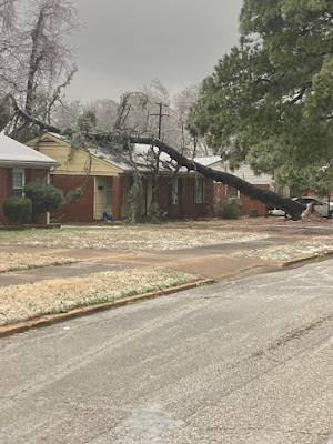
| Things keep getting worse today with the ice storm in the Mid-South. Here's an ice-laden tree on a house in Memphis. Photo from @JeremypierreFOX from Fox 13 in Memphis. |
We'll get to the early afternoon update for Vermont in a bit, but let's check in on the news elsewhere.
The ice storm has gotten pretty extreme in western Tennessee and Kentucky, and along the Mississippi River along the Arkansas and northern Mississippi border.
In Memphis, trees and wires are collapsing all over the place as the freezing rain continues to pour down. The City of Memphis tweeted urgent messages to stay home as electrical wires were falling all over the city.
The worst of the ice in this region seems to want to exactly parallel the path of that horrible tornado in Kentucky back on December 10.
The damaging ice is still expected to continue on in a band through southern Ohio, Pennsylvania, central New England and eventually Nova Scotia.
New York City got a bit of good news, though. Some earlier forecasts had called for a bunch of freezing rain in the Big Apple, which really would have been a major issue. Now, it appears that freezing rain will hit well north and west of the city.
Elsewhere, parts of Alabama and southern Mississippi are under the gun with a risk of tornadoes and flooding today.
As of mid-morning, the total number of people without power in the storm zone was 130,000 and that number was rising rapidly.
VERMONT IMPACTS
As of noon, the cold air has slowly been bleeding south in Vermont, but so far had only enveloped the Champlain Valley. It's easier for the initial push of a shallow layer of chilly air from Quebec to come into the Champlain Valley, as it's unimpeded by mountains.
Here's one aspect of this storm we're lucking out on. In the main ice storm region further west, there's a warm enough layer of air aloft so that this shallow initial push of cold air near the surface is creating freezing rain.
 |
| Despite falling temperatures and light snow early this afternoon, main roads remained pretty good around St. Albans. Things will worsen later as cold air spreads through much of the rest of Vermont and snowfall rates intensify. A tricky evening commute is in the cards for many of us. |
In the Champlain Valley and eventually the rest of northern and central Vermont, there's a thick enough layer of chilly air aloft so the precipitation starts out as snow and remains that way all the way to the ground.
There might be a narrow warmish air above that might temporarily make whatever snow falls early this afternoon kind of wet and heavy, but the cold air sloshing in turns it powdery in good time.
We need not worry about freezing rain or sleet or significant power outages at all in northern Vermont. Just snow, once the cold air routs the plain rain.
The snow has picked up a bit in northern sections early this afternoon and is starting to accumulate. It'll still be a relatively light snow until this evening, though.
Most everywhere else in Vermont was above freezing at noon, but that will change gradually during the rest of the afternoon.
I'm getting more and more concerned about some damage from freezing rain in far southern Vermont, roughly along Route 9. As the main wave of low pressure moves along the front, it will push warm air aloft a bit back northward, even as a thin layer of that cold air from Quebec takes hold near the surface.
A few places down near Route 9 could receive more than a quarter inch of ice building up on trees and power lines. A quarter inch thick layer of ice is where you start to see tree branches and power lines snap. Add some heavy, wet snow to the mix, which seems likely in this area, and you have trouble.
A few computer models suggest up to a half inch of ice. Those are outliers, but still worth paying attention to, just i case.
If you're north of a Manchester to Springfield line, I don't think this will be much of an issue.
Another area worth looking at is very roughly between Route 4 and Route 2. If the weather front on which the storm will glide along sets up where it's expected, it might really snow hard overnight in central Vermont.
The National Weather Service in South Burlington has this sniffed out already, and that's where they're expecting a good foot or more of snow. There's a chance that within this zone, this storm could really over-perform. The best moisture and the best atmospheric snow producing region both coincide in central Vermont.
This is not a promise and well short of a guarantee, but I suspect a few areas in central Vermont could conceivably close in on two feet of snow. We'll see.
In any event, light snow, or light rain far south, will pick up in intensity after sunset. It could really come down hard at times overnight especially in central Vermont.
Another update is coming for the evening. By then, meteorologists will have a nice suite of updated computer models to help update and adjust this very complicated forecast.
No comments:
Post a Comment