
 |
| That blur you see in the center right of this photo is a car that was skidding off Route 36 in St Albans by my house and landing on its side in a ditch. The driver was not seriously injured. |
The worst part of it was car crashes. As of late this afternoon, Interstate 89 northbound between Colchester and Georgia, Vermont was closed due to what sounds like a horrific crash in Milton.
WPTZ reports at least one person is dead and multiple vehicles were involved. A coach bus was on its way to pick up stranded people, which means there has to be quite a few. No further details were available as of this writing.
Elsewhere, Route 78 in Swanton was closed earlier this afternoon due to a tractor trailer crash. One lane of Interstate 91 in Hartford was closed for a time due to another crash. On my road in St. Albans, a steep section of Route 36, I watched earlier this afternoon as a car lost control slid off the road, became airborne, then landed on its side in a ditch.
I helped the driver out of the upended car and he did not appear to be seriously injured.
My theory is the snow was dry and people felt safer on that type of snow. It was so powdery that it was blowing off well traveled roads like the Interstates. Unfortunately, before the snow could blow off the roads, pressure from tires driving over it created a very thin layer of black ice,
If you plan on driving anywhere in Vermont this evening, don't. But if you must, be extra cautious, even as the snow tapers off.
 |
| Vermont Agency of Transportation web cam showed a snow-free Route 78 in Alburgh around 7 a.m. today..... |
But it appears southern Vermont got quite a bit less snow than forecast. Northern Vermont got about as much as forecast, except for the northern Champlain Valley. Franklin and northern Grand Isle counties seemed to hit the jackpot.
There, totals were closing in on ten inches by early evening. As of 5:45 p.m., my yard in St. Albans had received 9.5 inches of snow. Swanton reported 9.5 inches as of 2 p.m., when it was still snowing at a good clip there. Swanton probably ended up with close to a foot.
Elsewhere in the north, amounts were clustered tightly around 6 to 8 inches as of 4 p.m, so the predicted snowfall of 7 to 10 inches of snow will verify.
In far southern Vermont, 8.5 inches of snow was reported at Winhall and a little over six inches was reported at Readsboro and Landgrove as of late afternoon. They'll probably pick up only another inch or so of snow, so those predictions of a foot of snow might not happen. Except maybe up toward favored locations around Ludlow, Mount Holly and Shrewsbury. We'll see.
It looks like the burst of snow this morning in southern Vermont didn't last as long as forecast. Meanwhile, in the north, especially in the upper Champlain Valley and adjacent New York, the heavy snow began earlier than forecast. The heavy stuff was forecast to blow in around 11 a.m, but it was already snowing hard at 8 a.m. The Champlain Valley snow got lighter at around 4 p.m., which was about the time that was expected to happen.
Snow is still expected to gradually wind down over the next few hours. It'll be over by midnight at the latest.
We're still going to have a perfect winter day tomorrow, with sunshine, coldish but not frigid temperatures and light winds.
Sunday is looking problematic.
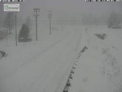 |
| ....and that same stretch of Route 78 in Alburgh looking much, much different shortly before 1 p.m. today. |
The first problem Sunday will be wind, especially in the Champlain Valley. The snow that fell today is remarkably light and fluffy. It won't take much wind to blow it around.
Winds are now expected to gust to 40 mph in the valley. That will cause blinding ground blizzards in exposed locations, and surprisingly deep drifts on roads
I expect they might actually close the Route 2 causeway between Colchester and South Hero, as there will be vast amounts of powdery snow blowing off the ice covered surface of Lake Champlain.
The other problem Sunday is a rising chance of brief but heavy snow squalls. First of all, the squalls cut visibility to zero very abruptly, making the chances of highway pileups pretty high. Additionally, temperatures are expected to rise to between 30 and 35 degrees ahead of the likely squalls.
So the first flakes that fall in the squall will melt on the highways. But rapidly falling temperatures will instantly freeze that water, and the blinding snow will accumulate on top of that. So when you hit the brakes when the visibility disappears, you won't stop. You'll just slide into the wreck ahead of you.
I'll update this as we get closer to the event.
No comments:
Post a Comment