
 |
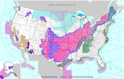
| That enormous pink area you see on this morning's National Weather Service home page is all winter storm warnings. That's one huge area! |
I'm not sure when was the last time I've seen such a large area of the United States under winter storm warnings all at once. A solid wall of winter storm warnings, meaning a storm is ongoing or imminent, stretches from Texas to Vermont.
Winter storm watches, meaning a nasty storm is possible, extend beyond that across New Hampshire and Maine
Other winter weather alerts are up for the southern Rockies. A vast area of the northern Plains and upper Midwest are enduring wind chill alerts. Parts of California and Arizona are dealing with gusty winds and freeze warnings.
CNN tells us that a 2,000 mile stretch of the United States with 90 million people are under winter weather alerts. That big number of people include the small collection of 643,000 people living here in Vermont.
Ice damage from freezing rain is going to be notable aspect of this storm. The ice is forecast to extend in a band from central Texas to southern New England. Some areas in this bad, including cities like Dallas, Little Rock, Memphis, Louisville and Cincinnati, expect enough ice to damage trees and power lines.
South of this line in warmer air flooding is quite possible in parts of Alabama and eastern Tennessee.
We'll find the band of snow north of the ice, running from Kansas to northern New England. In parts of the Midwest, some cities will receive more than a foot of snow. Northern New England is in for 8 to 12 inches, and this is a good spot to focus on Vermont.
VERMONT IMPACTS
First the summary, then the details:
Expected accumulation: 8 to 12 inches statewide, except possibly bit less far northwest and far south.
Timing: Thursday morning to Friday afternoon.
 |
| The National Weather Service snow forecast map issued this morning Almost everybody in Vermont should expect at least eight inches of new snow by Friday afternoon. |
Road conditions:
Thursday morning; Iffy north, not bad south
Thursday afternoon. Slick and not great north, somewhat iffy south
Friday morning: Really, really crappy statewide
Friday afternoon: Still not good, but slowly improving
Power outages: Isolated north, scattered south.
Now the details:
The forecast hasn't changed much since yesterday for areas north of Route 4. Areas south of Route 4 are in for a little more snow than earlier forecasts indicated.
Today, as expected is a warm one. And windy in the Champlain Valley. It's a good day to run to the store to grab the proverbial bread and milk (and beer and vodka for some). This won't be the Storm of the Century for Vermont.
But it will be a long lasting one, and will screw up travel on the roads from early tomorrow morning through most of Friday.
That long, slow moving cold front we've talking about will slowly sink southward. Light rain and wet snow is still forecast to develop late tonight and spread southward through the day. The snow won't come down hard, but temperatures will slowly drop. Roads will freeze up and become snow covered.
I'm not sure how the roads will be first thing in the morning. It all depends on the timing of the cold front and when temperatures dip below freezing tomorrow morning. The further south you go, the better they will be as it will take longer for the cold air to reach that area.
Across the northern half of Vermont, the snow will have a wet, sticky consistency for the first several hours of the storm. But snow won't come down hard during the day tomorrow, and only amount to one to no more than four inches by dark. That won't be enough to weigh down trees and power lines sufficiently to cause many problems.
It'll start snowing harder overnight Thursday, but by then, temperatures across the northern half of Vermont will be well below freezing, the snow will be powdery, so fallen branches and wires shouldn't be too much of a problem.
The issue will be roads. Not great for the Thursday evening commute, even worse for the Friday morning trip. If you can, work from home Friday morning or call in sick. Expect widespread school closures in Vermont Friday as well.
I'm a little more concerned about power outages in southern Vermont, as the wet snow will continue longer and better coincide with the heavier precipitation rates Thursday night. The snow will eventually turn more powdery in southern Vermont, too, but will it do that in time to prevent issues?
Also, to make things worse, freezing rain and sleet might mix in as well south of Route 4 especially, and even more especially around Route 9. People in southern Vermont should charge their devices and get their LED candles ready just in case.
The end result of this storm will be interesting. Northern Vermont in general will have about as much snow accumulation as the south. The whole state is expecting 8 to 12 inches, with perhaps a little less in the far northwest corner and far south.
But the moisture content of that snow will be very different from north to south. Near the Canadian border, the moisture content of the new snow will probably come out to between a half and three quarters of an inch. However, the further you get below Middlebury the higher the water content. Much of southern Vermont will have an inch or more of water in that snow.
A good portion of the snow in northern Vermont will be kind of light and fluffy. Southern Vermont, not so much, though the snow that falls later at night will be powdery, not sodden as temperatures plummet. Still, it will be much harder to clean up the expected eight inches of snow in St. Albans than it will in Manchester or White River Junction.
The snow should taper off during the day Friday from northwest to southeast.
Here's another way this snow will be difficult to clean up. By Friday, we're back in the deep freeze. We'll be in the teens to start the day and temperatures might actually fall a bit during the day. Most of us will be below zero Friday night.
Any water at the bottom of the new snow pack will freeze. You'll have to scrape that up, which is hard.
It also has even bigger implications for the Friday commute. I have seen this kind of storm before, and it is not happy. A thick layer of slush freezes to solid ice on the roads, then it snows on top of it. The roads are super slick.
That layer of ice is so stubborn that road crews have a hard time scraping it off, despite their good efforts. Salt won't work so great in the low temperatures expected.
Beyond this storm, the weather for the next few days looks, well, boring. Saturday will be cold, but beyond that, readings won't be too far from normal, and no big storms are on the horizon for at least several days after we get through this one.
No comments:
Post a Comment