
 |
| At first glance, the forecast snow amounts haven't changed much since yesterday. But the storm will probably create snow accumulation more variable than this map indicates. And there will be changes based on subtle shifts in storm track, and elevations where the snow falls, |
While the broad brush of the forecast hasn't changed all that much since yesterday, this is the type of storm that will guarantee surprises one way or another.
The key takeaways:
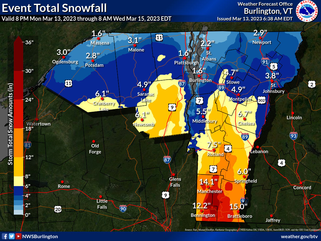
1. We know that far southern Vermont remains the main target, along with southern New Hampshire, southwestern Maine, western and northern Massachusetts, and the Hudson Valley and Catskills of New York.
Most (but not all!) people in those areas can expect at least a foot of heavy, wet snow, with a few places going up over 18 inches. This area is where we'll see most of the power outages Tuesday and Tuesday night.
2. In central Vermont, mid to high elevations can expect 5 to 10 inches of snow, locally higher in the Green Mountains, especially south of Sugarbush.
3. Far northern Vermont still looks pretty safe, for now, with just one to five inches expected. However, any part of Vermont gets way more or way less snow that forecast, it would be the north.
4. Who really gets nailed with snow will depend a lot on elevation. Lowest elevations, especially in northern Vermont, will probably mix with rain on Tuesday, and that will help keep accumulations down. But even in southern Vermont, we'll see big differences between valley floors and higher spots.
5. This is a weird, complicated nor'easter with a lot of moving parts. Forecasting who gets what during a New England nor'easter is always a challenge. This one is worse, and probably has a lot of meteorologists pulling their hair out.
WHY THE UNCERTAINTY
There's three main pieces to this storm all interacting with each other, the whole mess is taking a strange path, and the conglomeration could stall for a time, or pull a little loop de loop somewhere near southeastern New England.
Any little change to this projected performance by the storm could create plenty of curveballs. Maybe everything will happen a little southeast of current forecasts. Then the impact would be a little less in Vermont.
Or, things could nudge a little more to the northwest than everybody's been thinking this morning. That would dump more snow on all of Vermont.
I noticed National Weather Service meteorologists in Boston and elsewhere are saying the differences in storm forecasts between different computer models is larger than it usually is just 24 hours before a storm.
You can see the uncertainty in the worst case scenario/best case scenario maps the National Weather Service office has.
Down in Bennington and Manchester, the forecast is for something close to a foot of snow. But there's a 10 percent chance it could be as much as two feet, and a 10 percent chance that it would be as little as 9 inches.
The spread in northern Vermont is even more impressive. This morning's forecast calls for 2.2 inches of new snow in St Albans. But it could go as high as 10 inches, or St. Albans could get absolutely no snow.
Part of the problem in the north is that we know precipitation rates will be lighter than they will further south. This time of year, temperatures are a bit above freezing during the day and the sun's warmth can get through the clouds a little. That can make light snow mix with or change to rain on the way down from the clouds.
When it's snowing really hard, which is more likely in southern Vermont, that tends to cool all the air a little bit, so the heavy snow makes it all the way to the ground without mixing with or changing to rain.
THE RISKS
Today: As the storm organizes, it will be "meh" Monday with clouds, and scattered light rain showers around. That would be snow in the mountains. This won't amount to much at all. This morning and afternoon's commute should be fine.
Tonight: The rain and snow gradually ramp up. Any rain in the valleys will gradually transition to snow. Road conditions will deteriorate, especially south and mountains.
Tuesday: A rough day south and central. Heavy, wet snow, especially in Bennington and Windham counties. Winds will increase. That combined with the soggy snow will cause power outages to increase as the day goes on. Don't go out on the roads down in the principle storm zone. Driving will be difficult or impossible.
Central and north will be a bit questionable. The further north you go, the better things will be. At this point, conditions along and north of Route 2 don't look like they'll be that bad. Remember, though, that the heavier snow could unexpectedly creep north, which would change things dramatically.
Tuesday Night: Snow and wind continue. More awful roads, especially central and south. Power outages will continue. In the higher elevations where snow might not be as wet, blowing and drifting will be a problem.
Wednesday: The snow tapers off gradually, but the winds continue to blow, so things won't exactly be perfect anywhere in Vermont.
Thursday: All done! Time to clean up. Temperatures bounce back to near 40 in the valleys, so a little thawing should start.
No comments:
Post a Comment