 |
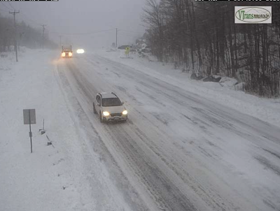
| Motorists carefully make their way down Route 4 in Mendon Mountain Saturday morning as the teeth of the snowstorm swept the state. This is a grab from a Vermont Agency of Transportation web cam |
Bands of heavy snow were lifting northward over the Green Mountain State this morning. Snowfall rates at times were one to two inches per hour early today. We even had a confirmed report of thundersnow in Milton at around 3:45 a.m.
Travel is not recommended the morning. I started hearing state snow plow trucks rumble by my house as early as 4 a.m., and they're continuing their work. But for the first half of this morning, snow will probably be coming down too heavily to really stay on top of it.
The roads are a mess statewide, and I've seen sporadic road and lane closures in spots due to slide-offs, crashes and stuck vehicles.
A for instance: Interstate 89 northbound near Exit 6 around South Barre was closed due to a car crash as of 7:30 this morning.
This morning's heavy snow bands we saw were created by a very strong storm system that brought severe thunderstorms and high winds to the Tennessee and Ohio valleys yesterday. This storm sent a surge of moisture into New England, which collided with somewhat colder air over Quebec. That was your recipe for heavy snow.
Gusty winds along the west slopes of the Green Mountains were - as expected - causing problems with blowing snow, making matters worse on the roads. I noticed a 6 a.m. gust to 44 mph in Rutland, so it's surely blizzardy there.
Wind gusted to 52 mph at around 5 a.m. in Bennington, where snow and sleet were falling. Sleet had been expected to make inroads into far southern Vermont and that's exactly what happened. There was a question as to how far north the sleet would get - maybe as far north as Rutland? But it looks like the sleet was limited mostly to areas along and south of Route 9.
And that sleet was switching back to snow as of around dawn.
Temperatures were creeping up early this morning, which might cause a few other issues. Many of us were in the low 30s, heading to temperatures of around 33 or 34 as the morning goes on.
Which means any new snow that falls will be wet and heavy, and could cause a few more power outages. That's especially true in southeastern Vermont. State Agency of Transportation web cams are showing trees already heavily weighed down with wet snow along Interstate 91 between Brattleboro and Hartford.
The downslope winds in Bennington and Rutland counties, and the wet snow in southern Vermont had caused about 2.200 power outages as of 7 a.m. Not huge, but still, not great, especially for the people with no lights. The number of outages was ticking up at the time.
 |
| Away from the hazardous roads, snow created a peaceful scene this morning in St. Albans, Vermont. |
Overall, snowfall amounts look like they'll end up pretty close to what was predicted statewide, Most of us will have a solid six to 12 inches of new snow.
Summits and east slopes of the Greens from areas west of Springfield then northward up to about Sugarbush are in the sweet spot for the most snow. I expect to hear of a few reports of snow totals creeping close to 18 inches by the end of the day.
Early this morning, there weren't that many snow reports in. The biggest totals I've seen so far are 10 inches in Rutland and 9.1 inches in West Windsor. I've seen several reports of six and seven inches of snow as of 7 a.m. As of that hour, the National Weather Service office in South Burlington reported 4.7 inches of new snow.
UP NEXT TODAY
As I write this around dawn, a new storm was forming near New Jersey while the original storm, near Buffalo was starting to fade.
The new storm on the coast is just about to steal our thunder, so to speak. It will take the best moisture with it as it begins to scoot eastward, out to sea. That means as the morning goes on and we get into the afternoon, the intensity of the snowfall will dramatically diminish.
The old storm will be fading nearby and will still have enough oomph to keep light snow falling all day, especially in northern and central Vermont. I have a feeling that far northern Vermont, which has received the least snow so far, will partly catch up from snow falling from the remnants of that dying older storm.
As of 7:30 a.m., my place in St. Albans had 4.3 inches of new snow. I expect to get to at least the predicted total of 7 inches by the time today is through.
With snow intensities lightening up this afternoon and temperatures rising to near or a tiny bit above freezing, road conditions should improve greatly this afternoon. It won't be perfect, but main roads should just be kind of slushy. You'll need to take it slow, but driving won't be the nightmare it is this morning.
The snow should taper off tonight. Quiet, seasonable weather will start tomorrow and continue through the upcoming week.

No comments:
Post a Comment