 |
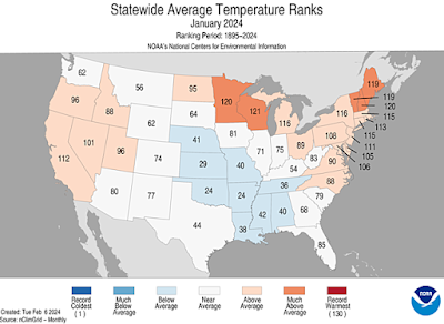
| Despite a sharp mid month cold snap, the middle of the United States was only slightly on the cool side for the month as a whole. New England and parts of the Great Lakes were much warmer than average. |
The frigid air broke nearly 2,500 daily minimum records from the Pacific Northwest to the Southeast, notes NOAA's National Centers For Environmental Information.
What didn't get so many headlines was the balmy weather across most of the United States toward the beginning and end of the month.
All that warmth and cold mixed together left the month as a whole kinda, sorta warmer than the long term average.
For the nation. the month ended up being 1.6 degrees on the mild side, which makes it the 47th warmest January of the past 130 years.
The warmest areas, relative to average, were the Northeast, Great Lakes region, and parts of California. It's interesting that only one state - Wisconsin - had one of their top ten warmest January on record.
Seven states, including Vermont had their top 10 warmest daily minimum temperatures on record. That's a testament to the incredibly cloudy skies in the Great Lakes and Northeast this January, which kept nights warmer than they otherwise would have been.
Those same clouds suppressed daytime highs somewhat, so no state had an average maximum in the top ten list. The closest was Maine, who had the 12th warmest average high on record
The coolest areas relative to average weren't that much nippier than average, but extended across the central and southern Plains, and a pretty good chunk of the Southeast.
January featured quite a bit of storminess in the Lower 48, making it the 10th wettest January in 130 years of record. Thirteen states had one of their top ten wettest January on record. The only dry areas were the northern Plains and parts of the northeastern Rockies. North Dakota had its tenth driest January on record.
The most notably of these storms was probably the deluge in Texas and Louisiana that brought a month's worth of rain in less than three days in the January 22-25 time frame.
Now we're into February. Record high temperatures embraced almost the entire northern tier of the United States during the first 10 days of the month. (Post on that February heat coming soon).
The rest of the month is looking somewhat on the cooler side for most of the Lower 48, but I'm not seeing a return to any sort of extreme cold anytime soon.
Figures for the world as a whole should be out within a week. Early indications are that January was the warmest on record for the Globe. It appears the United States was just a small relative cool spot at the start of the year.

No comments:
Post a Comment