Since last evening, there's been a few adjustments to the forecast going through today, but the general idea we've been hanging onto for the past couple days still holds:
Much of Vermont will see a foot or more of snow, which means a good portion of us will have the biggest snowstorm of the winter.
Never mind that it's spring.
DETAILS AND CHANGES
It was mostly light snow in Vermont between about 1 and 5 a.m. when things started up, but after that, the intensity of the snow started to pick up. Again, as expected. It should come down pretty hard most of the day. It'll probably lighten up to an extent in the far northwest this afternoon, but you get the idea.
Early this morning, temperatures were still in the 20s. That's good, because the snow coming down now is mostly pretty powdery, the kind that tends to harmless blow off of trees and power lines before causing too much trouble.
As of 6:30 a.m. VTOutages.org reported a grand total of one home without power in the entire state, in the town of Sandgate, in western Bennington County. Lucky them!
Clearly, the early portion of the storm isn't causing much in the way of power problems. The snow will turn wetter and heavier this afternoon mostly in the southern half of the state, so that's when we'll start to see power lines and tree branches snap.
Complicating things down in southern Vermont is the continued chances of rain, freezing rain and sleet late this morning and this afternoon. Mixed precipitation worked into far southern Vermont early this morning but the forces of cold from the north temporarily beat that back. Bennington had switched back to snow as of 6 a.m.
But it's March, so the warm air will come north again. It still looks like the mix or brief changeover will get as far as Route 4 or just a tiny bit past that. The further you work your way south, the more mix and rain you'll see this afternoon.
That mix and the wet nature of the snow, are the electricity killers this afternoon. Will this be yet another in a long string of storms since November that each cut power to more than 10,000 Vermonters? Maybe!
 |
| Wintry look for sure in St. Albans, Vermont this morning. |
The powdery stuff coming down early this morning will turn more dense and a little wetter this afternoon, but it won't quite be the wet cement you're seeing further south.
There probably will be a few power outages today in the northern half of the state but I'm guessing it won't be an enormous problem there.
Road conditions will stay lousy all day. Road crews are out, and they'll stay out all day. But there's only so much you can do when it's snowing as hard as it will today.
Snow Totals
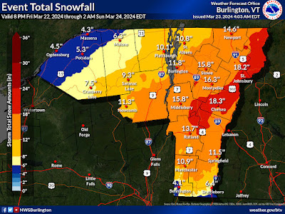
Forecast total snow amounts continue to tick downward slightly in far northwestern Vermont with a grand total now expected to be around 10 inches there. The deepest moisture will just barely clip that part of the state.
The sweet spot for snow in Vermont will be sandwiched between the mixed precipitation in the south and the slightly drier air in the northwest. That means an area from the central Green Mountains to the high elevations east of Barre and then up the northern Connecticut River Valley and Northeast Kingdom should get the most.
There, at least a foot will pile up, with many places seeing 18 inches. I wouldn't be surprised if we see a couple two foot totals in this part of the state.
Totals over a foot should extend possibly as far south as Manchester and Springfield, despite some brief rain or mix this afternoon.
Some parts of southern Rutland and Windsor counties had already picked up six to eight inches of snow as of 8 a.m. Most places were in the two to four inch range as of 8 p.m. but it's early in the storm.
Down toward Bennington and Brattleboro, only about four to eight inches is on the table. The mountains east of Bennington will probably do better than that, though.
How It Ends
Snow will end west to east this evening, being mostly out of hair by midnight. By morning, skies should be partly clear, with no snow.
Sunday won't be the bluebird day I originally hoped for. There will be some sun and breaks in the clouds, but also some flurries as moisture lingers. Still a gorgeous day to hit the slopes or play in the snow. You'll still need those sunglasses as it will be incredibly bright out there with the high sun angle.
One thing to watch out for: I wouldn't be surprised if there are some snow slides and maybe avalanches in steep back country. I noticed there's an avalanche watch in effect for the White Mountains of New Hanpshire, especially near Mount Washington and the rest of the Presidential Range.
Here in Vermont, those heavy mountain snows of the past week, plus today's big storm that all came with wildly varying temperatures and lots of wind, has surely made the snow unstable in some steep terrain in the Green Mountains and Adirondacks. The back country is super tempting after all this snow, but watch your back!
It's still going to warm up during the week, peaking at temperatures close to 50 in some spots Wednesday. You might hear news of another big winter storm in the northern Plains and western Great Lakes and start to shudder. At least if you want spring to return.
But you can relax. That storm will go by far to our west. We'll probably just get some light rain showers out of that one between Wednesday night and Friday. No biggie.


No comments:
Post a Comment