I hope you got outside in Vermont today but it was a perfect winter day.
 |
| Final snowfall map from the National Weather Service in South Burlington. Click on the map to make it bigger and easier to read. |
For awhile today, in the early afternoon, it was only 33 degrees here in St. Albans, but the winds were light and the sun was strong. I was comfortably outdoors shoveling snow in pants and a black t-shirt. No jacket.
Central and southern Vermont spent the day digging out from the deep snow from yesterday. Of three sibling in the Green Mountain State, I'm the only one who had an easy time of it.
One sister in Shrewsbury came up with a final total of 32 inches - nearly three feet. Another sister in low elevation West Rutland came up with 22 inches. As for me, I had an easy-peasy six inches.
In Vermont, I counted no fewer than 21 towns that got at least two feet of snow. Most of those were in Windsor County, with Rutland County running a strong second in the snowfall derby.
The highest total was 33.1 inches in West Windsor.
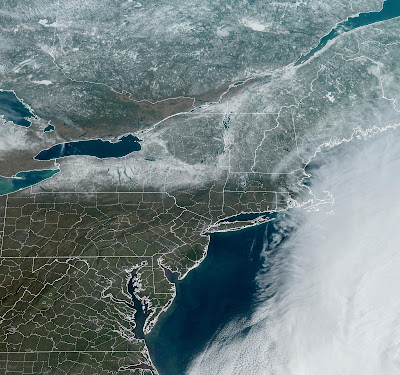
The clear skies today helped us see a very cool satellite photo.
You can see the snow ended in bare ground in Massachusetts a very little bit south of the Vermont and New Hampshire borders.
You can also see a stripe bare ground in the St. Lawrence Valley of Ontario and Quebec, just northwest of New York State.
The storm missed that area. Snow is on the ground north of the St. Lawrence Valley. That's mostly this winter's snow that hasn't melted yet.
FORECAST UPDATE
The fresh snow still looks like we are going to have a bitterly cold Monday morning for this time of year. Temperatures will really start to crash right around sunset.
The cold hollows of the Northeast Kingdom, and I suspect at least a couple mountain valleys in buried Windsor and Rutland counties could go below zero tonight. The rest of us will stay in the single numbers and teens.
Warmer air this week will melt a lot of the snow, especially northwest.
Northwestern areas will be the warmest for at least two reasons. There's less snow there, so the sun will heat the ground a little better. Bare spots will be already opening up in that neck of the woods tomorrow.
Eastern Vermont and maybe to a lesser extent in Rutland and Bennington counties, should stay somewhat cooler - in the upper 30s to mid 40s Tuesday through Thursday, as a chilly southeast wind from the Atlantic Ocean blows in.
The Green Mountains will block a lot of that chill, so the Champlain Valley should get to near 50 degrees at least daily Tuesday through Thursday. In what will be the snow-free St. Lawrence Valley in northwest New York, temperatures near 60 are possible.
We still don't know if an ocean storm late in the week will completely miss our area or bring in a little rain. So far, little or no rain is in the forecast. As I said this morning, I don't see an immediate threat of flooding from the snowmelt.


No comments:
Post a Comment