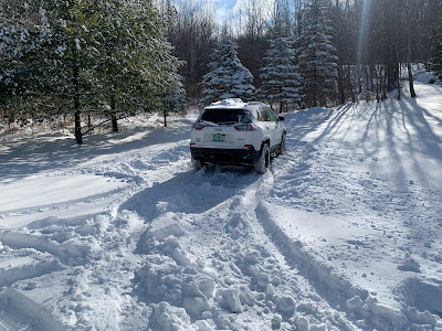
Well, that was fun.
South central Vermont took the brunt of it, with many reports of over 20 inches of snow.
So far, Woodstock is wining the snow total derby with 28 inches. Ludlow is close behind with 27.3 inches.
Shrewsbury is also close with 26 inches, and that was measured a few hours before it stopped snowing. We're awaiting an update.
Some towns at lower elevations had surprisingly high amounts. Depending on where you measured in town, West Rutland had between 19 and 22 inches. Two feet of new snow covered Chester and Norwich.
Overall, the storm was colder and a little further south than forecast. Those big snow totals happened in a region where some mix with rain was anticipated, which would have held down snow totals. But the rain ended up being confined to far southern Vermont.
.Up in central Vermont, about a foot of snow came down. In the Champlain Valley it was close to a foot down near Middlebury, around eight inches in and near Burlington and four to six inches up in Franklin County.
 |
| This morning's traffic cam of Route 9 in Searsburg, Vermont shows a tractor trailer rig in the ditch. |
The National Weather Service office in South Burlington said there have only been five snowstorms with greater totals later in the season than this.k
In David Ludlum'sVermont Weather Book, I could find only a few examples of snowstorms this big or larger around this time of year and later. Most of them happened a long, long time ago.
They were on March 26, 1847, March 28, 1919, April 1, 1807, April 2-5, 1975, and arguably April 6-7, 1982 in far southern Vermont. There might have been couple others I missed. But you get the point.
It was a wet storm, too. Melt down the snow in Montpelier and you get 1.14 inches of rain, making Saturday the "wettest" March 23 on record there.
Melted snow at Lebanon, NH/White River Junction Vermont was two inches. Melt down the snow, freezing rain and such in Bennington and you also get two inches.
The fact the storm was colder than anticipated minimized power outages. Prior to the storm, I was yelling and screaming about how the power would go out. In the end, Vermont outages peaked at under 2,000.
Freezing rain did coat trees roughly along Route 9 from Bennington to Brattleboro and on into New Hampshire. The freezing rain was worse in the Granite State and in Maine, causing trees and power lines to fail there
TODAY
With fresh snow pack, temperatures plunged early this morning as skies cleared. It wasn't so bad in Vermont, because it didn't clear up until early this morning -- mostly low to mid teens with a few upper single numbers.
But in New York, which had more hours of starry skies, it got really, really cold for this late in the season. Plattsburgh bottomed out at just 1 above zero, a record low for the date. Saranac Lake got down to minus 5. Glens Falls saw minus 3.
It goes to show how a deep snow cover can chill the air. Especially when it's clear at night.
All this snow will help keep us somewhat refrigerated for the next few days. But it will still thaw and melt coming up. It is spring, after all.
Today should only get into the low to mid 30s in most valleys, which is about 10 degrees colder than average. But it will feel fantastic for outdoor sports and playing in the snow. Just bring sunglasses, as I've mentioned before. The high sun angle this time of year on fresh snow makes things absolutely blinding.
There might be a few clouds around today but a fair amount of sun, too.
In the back country, there's an avalanche warning for the White Mountains of New Hampshire. I still think we could see at least some small avalanches in steep back country of Vermont, too.
Tonight, with clear skies and that fresh snow cover, it'll get really cold again. Some spots in the Northeast Kingdom could go below zero. Most of us will be between 5 and 15 above.
Then the thaw begins
THE UPCOMING WEEK
You'll probably hear news of a new huge storm today through Tuesday. It's true a huge storm in the middle of the nation is going to cause everything from a blizzard to wildfires to possible tornadoes. But that storm won't really be our problem here in Vermont.
More on that in a sec.
The nice thing about cleaning up after a snowstorm this late in the season is you don't have to be that picky.
The snow won't last long. It will melt pretty quickly. All you have to do is clear it away enough to get out and about. You don't have to do a complete job because the spring sun will do that for you.
That said, it won't be as warm as it otherwise would be. All this snow on the ground is reflecting the warmth of sunlight back to space. There might be some spot 50 degree readings Tuesday and Wednesday, but most of us will stay in the 40s.
That big storm I mentioned in the middle of the nation will head up through the Great Lakes and then to Hudson Bay, Canada by later Wednesday.
The storm will swing a weakening cold front through Vermont Wednesday night with a few sprinkles.
A new storm might form along the front and move northeastward, giving New England some rain and possibly mountain snow Thursday or Friday, but it's too soon to figure out whether or how much precipitation we'll get.


No comments:
Post a Comment