Sunday, August 11, 2024

Persistent July Heat Broke Impressive Records In Several U.S. Cities

Clouds billow up on July 17, taking advantage of another
in a string of steamy very warm days in Vermont this summer.
Many cities on the west and east coasts had their hottest
July on record, and those who didn't came close. 
 We in Vermont weren't the only ones who endured what seemed like never ending summer heat during July. 

Plenty of other cities, mostly in the West, with some in the East were even more impressive. 

Death Valley, California had the hottest month ever observed at any place on Earth in July. The average temperatures, as measured at Furnace Creek there, was 108.5 degrees during July. That breaks the old record of 108.1 set in 2018.

The list of cities reporting their hottest July include Sacramento, Bakersfield and several other California cities, Las Vegas, Portland, Salem, Redmond and Eugene, Oregon; Spokane, Washington, St. George, Utah, Albany, New York, Hartford, Connecticut, Concord, New Hampshire and Orlando and Fort Lauderdale, Florida. 

I'm sure I'm missing many other cities that had a record hot July, but you get the idea.

Here in Vermont, Burlington "only" managed to see its third hottest July on record this year. 

While the East and West coasts were hot, the middle of the United States was near normal, or even a little cooler than average in spots. 

Within a few days, we should see July data that assesses the United States as a whole. At mid-month or so, we'll know how July fared across the globe. Early indications are July ended a 13-month long stretch of consecutive record warm global months. Even so, July for the world as a whole will surly come in much warmer than the 20th century average 

We do know in some areas, including some weird spots, the extreme heat continued into August. For example, how about a nice tropical beach vacation on the Arctic Ocean shores in far northwestern Canada and northern Alaska? 

Deadhorse, Alaska, right on the Arctic Ocean shore in not normally a tropical paradise, but it reached 89 degrees there on August 6.  That is likely the hottest it's been anywhere in the world north of 70 degrees latitude. 

In the neighboring Northwest Territories of Canada in the far north, all time record highs were set a Little Chicago, 96.6 degree; Fort McPherson, 94.8 degree, Inuvik, 94.6 degrees and Trail Valley, 33.6 degrees. 

Although much of the eastern United States has cooled off somewhat from the persistent heat of July, it's still quite warm in much of Canada as a strong ridge of high pressure in the middle of that nation holds firm.

Summers are getting longer in the northern hemisphere with climate change. Which of course means this summer is definitely not over yet.  

Debby Was A Vermont Windbag, But We Dodged A Huge Flood Bullet

Vermont mostly avoided flood damage from former
Tropical Storm Debby. Further west in New York,
some of the damage was extreme, such as in this
photo of Canisteo, New York. Photo by Bob
Lonsberry via Facebook.
 I was playing pick up sticks in my yard Saturday evening. 

There are so many small and medium sized branches down from those strong winds we had Friday evening from former Tropical Storm Debby. It's a project that probably will continue for days. 

Count myself very lucky, though. I have no damage.  And bonus: The gales knocked down a pretty good sized dead tree that I was planning on cutting down. Saved me work, and the dead tree didn't land on anything I care about. 

Meanwhile, more than 8,000 homes and businesses, almost all of them in northwestern Vermont, were still without power as of 7 a.m. this morning. That's 36 hours after the winds arrived. With all the trees and wires down, it's going to take awhile to fix everything. 

People are also dealing with homes with roof and other damage either from high winds or falling trees. Cars have been damaged or destroyed, too. Large trees are a real mess to clean up.

But notice I haven't mentioned flooding so far. 

Vermont really dodged a bullet on that one, given there were only a handful of reports of minor water damage here and there. No big deal at all.

That's awesome for us, as early forecast had us getting battered by inches and inches of rain. We braced for another flood disaster.

But, as forecasts became clear on Thursday, former Debby's path was taking a jog to the west. That meant the torrential rain would become somebody else's disaster.

Sadly, there were many thousands of somebody elses who dealt with flooding - in many cases catastrophic - from Sarasota, Florida to Montreal and the Laurentian Mountains of Quebec, Canada. 

There were some impressive rainfall totals in Vermont, so I imagine there is some flood problems that haven't been reported in the media.  But nothing catastrophic. 

The rain in Vermont apparently stopped just in time, right before anything really bad happened. Elmore and Corinth, Vermont reported just under four inches of rain from former Debby. There were many, many Vermont reports of between two and three inches of rain. 

Head a little west into New York State, though, and things got seriously worse. In northwestern New York, North Lawrence reported 7.35 inches of rain. North Emeryville and Fort Covington, New York also saw more than seven inches of rain. There were many reports of four to six inches. Flooding got pretty bad in and near New York's St. Lawrence Valley. 

That flooding crossed the border in Quebec. Montreal has 6.18 inches of rain Friday, the wettest day in that city's history. The flooding in Quebec closed at least 100 roads, forced hundreds to evacuate and set off landslides in the Laurentians northeast of Montreal. 

The epicenter of the worst flooding was in southwestern New York and northern Pennsylvania. Video showed water roaring through a neighborhood in Canisteo, New York, uprooting trees and sheds. Other towns were devastated as well.  Small communities across northern Pennsylvania were inundated, reminiscent of the floods Vermont endured back in July.

Downtown Annapolis, Maryland was under as much as three feet of water from Debby's storm surge Friday. Down in Sarasota, Florida, close to a foot of rain swamped numerous neighborhoods. 

Vermonters dodged another bullet, too. Former Debby prompted tornado watches up and down the East Coast from Florida to Vermont. 

There ended up being close to three dozen tornadoes associated with Debby from Florida to the lower Hudson Valley in New York. Despite the tornado watch in the southern half of Vermont Friday, there were no twisters in the Green Mountain State. 

Now that Debby's gone, much quieter, though at times unsettled weather is moving into the Northeast for several days at least. No extreme are in the forecast for now. But give it time. I'm sure more trouble will brew soon enough.  

Saturday, August 10, 2024

Debby Does Damage, Surprises Vermont With Destructive, Dangerous Windstorm

 It wasn't flooding we should have worried about. 

Surf was really up in St. Albans Bay Friday evening
during our surprise high winds from former
Tropical Storm Debby.
All day long Friday, we watched, with breaths held, to see whether we'd see another destructive flood in Vermont, all due to former Tropical Storm Debby.  

As we now know this Saturday morning, it wasn't the rain we should have worried about. At least not in Vermont. There was very little flooding in the Green Mountain State. It was mostly in New York, Pennsylvania and Quebec 

But former Tropical Storm Debby had one big surprise parting shot for Vermont as it lifted into Quebec Friday evening:  

Debby was quite a blowhard in the end. The wind nailed us. Big time.  Especially in the Champlain Valley. 

It was quite a surprise. 

DAMAGE REPORTS

Forecasters knew well ahead of time there would be strong winds, especially in western Vermont. A wind advisory issued well in advance warned of wind gusts up to 50 mph that could knock down a few trees and power lines. 

The wind, however, was stronger, and more widespread than anybody thought. The wind gusted to 62 mph at the National Weather Service office in South Burlington. I can't ever recall wind speeds that strong in the summer, outside of severe thunderstorms of course. 

Other areas in the Champlain Valley also had gusts to near 60 mph, possibly more in some spots, judging from damage reports. 

Following is just a few incidents I ran across. (Some might be unofficial reports, but they are reliable). Also, it's just a sampling of the trouble the high winds caused. It's definitely not a complete accounting. 

A tree apparently crushed a house in Alburgh, trapping a resident inside. Colchester Technical Rescue had to go up and get the person out, and the Red Cross was helping with displaced residents. 

Debris blowing from this house in St. Albans, Vermont
Friday evening after strong winds tore off a metal roof. 

Another tree fell on a car in Fairfax and there were reports of injuries. I don't know how serious. Trees were also reported down on houses in Swanton and Williston. Probably other towns, too. 

In St. Albans Bay, I witnessed the wind rip a metal roof off of a house.  Roads in St. Albans - like so many other spots in Vermont, were littered with fallen branches and trees. 

Middlebury Police advised residents to stay off the roads, as many of the town's streets were blocked by fallen trees and wires. Milton Police issues similar warnings. Route 116 was closed near Middlebury and Bristol due to fallen trees.  Route 116 in the middle of Starksboro was also blocked by fallen trees. 

A traffic signal was seen dangling dangerously low and broken on busy Williston Road in South Burlington. 

It was dangerous out there, as you'd imagine. I was removing a large branch from the middle of Georgia Shore Road near the Georgia/St. Albans line. A big gust came up and I heard a large tree cracking next to me. And I was under power lines. So I decided to abandon that little project and move on. 

At its worse last evening, more than 49,000 Vermont homes and businesses were without power. As of 6:15 a.m today, more than 26,000 customers were still out. The outages were distributed statewide, but were most numerous in the Champlain Valley. 

If there was any saving grace, the high winds really last only a couple of hours before quickly diminishing. 

FLOODING AVOIDS VERMONT, BUT....

Another good thing, of course, was the lack of new flooding in Vermont. The initial band of rain Friday morning was heavier than expected, so that raised some fears. 

A new band of torrential rains arrived in Vermont in the late afternoon and evening, just as expected. But that line of downpours cosplayed and Olympic sprinter, and raced in and out of Vermont before it could linger enough to do any harm. 

This small branch got stabbed into my St. Albans,
Vermont lawn when it was blown off a tree in
Friday evening's strong winds. (My property sustained
no damage other than small branches blown down).

The heaviest rain fell to our west and southwest, in New York and Pennsylvania, where the flooding was described as catastrophic in some areas. 

More than six inches of rain hammered parts of the Montreal, Quebec area, causing severe flooding there, too. 

Back here in Vermont, meteorologists will definitely spend a lot of time examining how they missed anticipating the strong winds - nobody, not any meteorologist I know if, not any computer models I know of - predicted it would get that bad. 

That's not at all a slam against the National Weather Service office in South Burlington or any other Vermont meteorologist. A storm transitioning from tropical to non-tropical, moving pretty much overhead over complex terrain is a nightmare to forecast. 

UP NEXT

Quieter weather is on top in Vermont for the foreseeable future. Debby is way out of our hair now. Today will actually be quite nice, with partly sunny skies, a nice breeze and warm temperatures near 80.

A dip in the jet stream and a cool pool of air aloft will keep things unsettled tomorrow, Monday and perhaps beyond. 

The cool air in the upper atmosphere will encourage instability. That will turn on the scattered shower activity Sunday afternoon through at least Monday. It won't rain continuously, and any rain won't be nearly heavy enough to cause flood problems. 

I also don't see signs of any temperature extremes for at least the next week. 


Friday, August 9, 2024

Late Friday Afternoon Update: Thick of Former Debby Moving Into Vermont Now.

UPDATE 8:30 p.m FRIDAY
After a relative lull, heavy rain was moving back into
Vermont as of shortly before 5 p.m.  The next few hours
will be the stormiest of this whole former Tropical Storm
Debby episode. UPDATE: 8:30 p.m.

As you may have noticed, this storm turned out to be a surprise, rather destructive wind storm. 

More than 48,000 Vermont homes and businesses without power as of 8:30 p.m.

Lots of damage. I witnessed a roof blow off a building in St. Albans Bay this evening. 

I noticed the wind gusted to 60 mph at the National Weather Service in South Burlington. I've never seen wind gusts in the region in the summer, except in severe thunderstorms. 

The wind should gradually subside overnight. Full report on this tomorrow morning. Stay safe! 

PREVIOUS DISCUSSION

As of late this afternoon, we're now in the most exciting part of former Tropical Storm Debby in Vermont. 

The rain is the heaviest it will be for the entire storm, or if it's not where you are, it soon will be. If we're going to get any flash flooding at all, it will between now (I'm writing this around 5 p.m.) and midnight. 

New York State, as expected, is taking the brunt of this.  Flash flood warnings and storm warnings are flying in large swaths of the Empire State as of 5 p.m. I noticed this morning and early afternoon's round of heavy rain also swamped the Montreal area with flooding, too. 

One thing that probably helped tremendously was a relative lack of rain in Vermont between noon and 3 or 4 p.m.

 Very few spots -  except maybe far northwestern Vermont - got more than a tenth of an inch of rain in the early and mid afternoon. 

This interlude lasted even longer in the flood-wracked Northeast Kingdom. After enduring another flood warning early today after a bout of overnight downpours. St. Johnsbury mustered just 0.05 inches of rain between 6 a.m. and 2 p.m. 

The biggest threat with former Debby is from small brook, creek and stream flooding. That relatively calm interlude allowed those streams to settle down a bit, making them just slightly more able to handle the big onslaught of downpours now moving into the state. 

That said, it still won't take all that much in the way of downpours to set off flash flooding, so some seems inevitable this evening. It still looks like it won't be as bad as July 11 or July 30, but I imagine there will be some damage out of this, if there isn't already. But it will be scattered damage, I'm sure. 

The commute home this evening is quite a slog for many of us with reduced visibilities in areas of heavy rain, hydroplaning because of all the standing water and perhaps some washouts starting on steep dirt roads. 

Thunderstorms and gusty winds mixed in surely won't help.

Winds have been light most of the day, but as expected, have been starting to ramp up from south to north, especially from the Green Mountains west. The wind abruptly started gusting to 40 mph in Bennington shortly before 3 p.m., and that's been working north since.

We can still expect wind gusts in the valleys of southwestern Vermont, the Champlain Valley and the western slopes of the Green Mountains to gust past 50 mph in some spots through the evening. They'll diminish south to north later this evening

The gusty winds hitting trees with shallow roots in basically mud is a recipe for some of them to topple over.  

We're still looking the risk for severe thunderstorms and even a possible weak tornado or two for the next few hours. Some storms in southeastern Vermont were vaguely rotating as of mid-afternoon, but the rotation hadn't tightened up nearly enough yet for any tornadoes. 

The main line of storms, which could produce spin ups, was far southwest Vermont as of 5 pm. and heading northeast. Don't know if there will be any spin-ups or not, but there's still a low chance it could happen.

This mess will all be over by midnight or shortly thereafter so we're almost out of it. 

Stay safe this evening. It's not as bad a storm as those on July 11 and 30, but you want to stay on your toes regardless, and heed any weather warning that comes up for your area.

Early Afternoon Vermont Flood Update: Western Vermont/NY Getting Most Of It for Now

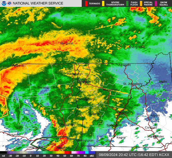
Weather radar was really lit up, especially in New York and
northwestern Vermont as of 1 p.m. or so. Expect the heavy 
rain to continue focusing on New York, but some of it
will spread further in Vermont, raising flash flood
threats in the Green Mountain State as well. 
UPDATE: 2 PM

Tornado watch just issued for Vermont from Addison and Windsor counties south until 10 p.m. tonight.

PREVIOUS DISCUSSION

So far today, rainfall continued to exceed expectations a little bit, so wary meteorological eyes continue to watch what happens with the remnants of Tropical Storm Debby in Vermont through this evening. 

The good news is there's been a relative lull in rainfall in the eastern half of Vermont, which means rivers that were starting to rise sharply have stabilized. A flood warning that was in effect for the area around St. Johnsbury, Lyndonville and Barton has expired. They're not entirely out of the woods, as more heavy rain is due there later, but at least there's a break.

Western Vermont, especially the immediate Champlain Valley and in through most of Franklin County in the northwest, along with New York State, has been and is seeing the bulk of the rain as of 1 p.m.

A flood warning went up around Essex, New York and on across the lake around Vergennes, Ferrisburgh and Charlotte as a particularly intense blast of rain went through that neck of the woods at mid-morning. 

Another, more serious looking flood warning just went up after 12 noon for a region on either side of the northern portion of Lake Champlain. In Vermont, this is in northwest Chittenden County, Franklin and Grand Isle counties. Basically from Colchester north. Up to 2.5 inches of rain has already fallen there. Up to another 2.5 inches of rain could fall, so that could be really serious.

I see that Plattsburgh, New York had already gotten a storm total of two inches of rain as of 1 p.m, and it was still raining pretty hard there. 

So far the only report of trouble with this is about three or four inches of water on Interstate 89, a little north of Exit 16 in Colchester 

 Northern New York got no real break from the heavy rain, so that's where the most serious concern for flooding is right now. There's already a huge area of flash flood warnings in southwestern New York centered around Binghamton. That torrential rain seems destined to head toward the Adirondacks and St. Lawrence Valley later today.

Rainfall rates this afternoon over in New York could be one to two inches per hour. Some places in the Adirondacks could get five inches of rain. With the steep terrain over there, flash flooding could get pretty scary.

We'll also have to watch and see whether that concentrated area of rain clips far northwestern Vermont later, because of all the rain that's fallen there. For the rest of Vermont, we still have to worry some about flash floods, especially when the heaviest rain gets here in the late afternoon and early evening. 

As the center of former Tropical Storm Debby draws nearer this afternoon, we'll have to be on the look out for embedded thunderstorms, a few of which might contain damaging winds. 

The thunderstorm risk for western Vermont from Burlington south has been upgraded from level 1 marginal risk  to level 2 slight risk, which suggests there could be more than just isolated trouble with today's storms. 

In this western Vermont slight risk, there's a 5 percent chance of a tornado within 25 miles of a given point. Yeah, that's low odds to be sure, but more than we usually see in Vermont. There's a decent chance of a quick spinup, but of course that's far from guaranteed. If a spinup happens, it could come at dusk or after dark, making such an event that bit more dangerous. 

That said, rainfall patterns have been transitioning from a steady if sometimes heavy rain to more cellular type things. That means heavy showers and thunderstorms. With this new regime this afternoon and evening, the rainfall might be less constant and include some breaks, but when the rain does come, it will often be ferocious. 

Winds should really pick up in western Vermont especially today as the circulation of former Debby comes closer. We still expect winds to gust to 50 mph in a few spots. This is just regular winds, outside any severe thunderstorms. So power outages are a decent bet here and there. 

Since we're not entering the heart of the storm danger period - lasting from now into the evening - stay weather aware and pay attention for  any flood or severe storm warnings that might be issued over then next several hours. 


Friday Morning Vermont Debby Update: Early Rain Over-Performs; Flood/Wind Risk Continues

The National Weather Service in South Burlington 
released this rainfall prediction map. It includes what
already fell, and what will come down through 
Saturday morning. As you can see, New York
gets the heaviest rain. We'll have to watch for
pockets of locally heavier rain in Vermont that
might not be depicted in this map. Still, more than
two inches of rain is fairly impressive .
 The first batch of heavy rain associated with former Tropical Storm Debby lifted through Vermont overnight and early this morning as expected. 

Unfortunately, it over-performed in central and northern Vermont dumping more rain than predicted in many areas. That primes the pump, so to speak, for possible additional flooding later today.

We can also expect some wind damage in parts of Vermont today, along with isolated instances of severe thunderstorms. There's even a very low, but not zero chance of a brief tornado this afternoon or evening. 

Despite the trouble brewing in Vermont, the bigger threat for flash flooding has continued to focus on northern New York and a little less on the Green Mountain State for this event. 

Let's take it step by step again.

THIS MORNING

You probably did hear the occasional roar of downpours on your roof overnight and early this morning. One to 1.5 inches of rain, with spot amounts to two inches fell in a band from eastern Addison County, through Barre-Montpelier and on off to St. Johnsbury. 

Both Montpelier and St. Johnsbury reported about 1.7 inches of rain already as of 7 a.m. since this all started last night. 

This is precisely the wrong area to see the heaviest rain, as that zone has experienced the worst of the flooding this summer. 

Already, a flood warning was posted this morning for parts of the Northeast Kingdom from St. .Johnsbury to points north and west including Lyndonville and Barton.

 This Northeast Kingdom region is especially prone to added flood damage because the hasty repairs to roads and culverts after the massive July 30 flash flood are not stable or complete. So the added downpours this morning could be causing more damage.

All that said, the biggest flood threat from the remnants of Debby today are across northern New York, where the heaviest rain is falling, and will fall.

The Mad River at Moretown rose by more than three feet in just a few hours early this morning, but appeared to be stabilizing below flood stage at dawn. Still, since river levels are now higher than expected, that increases the chances somewhat that flooding could occur this evening. 

All that said, the biggest flood threat remains in New York. But Vermont will need to be watched closely today. 

TODAY

You might notice a lull in the rain for awhile this morning but it will pick up again. The steady, heavy rain today and this evening will focus on New York State, but there will be fitful showers and storms throughout the day across Vermont.

The showers, rain and downpours will tend to be out concentrated from mid or late afternoon into the evening. That's probably when we'll have our biggest risk of any flash flooding. Again, it's one of those cases where not everybody has a crisis. Most places should be fine with the amount of rain we received and are about to get. 

However, some places will be dealing with washed out roads, basement flooding and other problems you get with intense rainfall rates.

We'll have to watch rainfall rates and whether any particular spot is hit by repeated downpours. If  former Debby behaves as expected, Vermont flooding problems will probably be relatively minor - mostly nuisance level - at least in most cases.  If former Debby really over-performs with especially heavy downpours, all bets are off. 

The National Weather Service and other meteorologists are watching this closely.  

There's other trouble brewing today, too: 

Wind

The remnants of Debby still have some wind energy.  That will channel gusts from south to north up the Champlain Valley. Also, southeast wind going up and over the Green Mountains will tend to grab some higher speed winds from aloft and bring them to the surface.

It's the classic western slope windstorm type deal we sometimes get in the winter. So, the National Weather Service has issued a wind advisory for the Champlain Valley and western slopes of the Greens. A wind advisory like this is fairly common in the winter, but very rare in the summer. But here we are. 

For today, all this will result in possible gusts in a few spots of up to 50 or 55 mph. That's enough to break branches and uproot a few trees and take down a few power lines.  Remember, trees uproot more readily when the ground is wet and soggy, so that will be an issue. 

Severe Storms/Tornado?

With any tropical or former tropical system, you often seen rotating storms, especially along and east of the storm's track. That could happen in Vermont. I would say if this does happen, it's most likely along or south of Route 2. 

A few storms could develop strong, damaging winds.  Since these storms will be rotating, we can't rule out a brief tornado somewhere in the state. The chances are low, but they're definitely not zero. These kinds of things with tropical type systems can develop and fade fast, so you might not much advance warning, if any warning, in the case of anything developing. 

IT ENDS QUICKLY

The heavy rain and wind will shut down quickly in Vermont tonight.  Western areas might see things settle down by 9 p.m., and by midnight or so east. Runoff from the heavy rain will continue to be an issue overnight, so we'll need to watch how river levels go. 

Most of the river flooding will be in northern New York. But we'll need to keep our eye on the Mad River, and possibly a few others. If any rivers do flood in Vermont, strong chances are it would be minor flooding, not the major flooding we saw in July.

All bets are off, though, if the rain today is much heavier than forecast. 

Saturday actually still looks like a nice summer day. Showers should re-develop Sunday afternoon and evening, but they shouldn't be intense enough to cause any new flood worries. 

Thursday, August 8, 2024

Thursday Evening Update: Flood Risk Continues In Vermont/New York With Debby; Rather Weird Weather, Too

Expected rainfall amounts through Saturday with
the remnants of Debby. Less rain is expected in
Vermont than earlier forecasts, which will help prevent
another big flood disaster. But local flash loods
are still a real risk. 
As advertised, clouds increased this afternoon across Vermont and surrounding areas as now ex- Tropical Storm Debby makes its way towards us.  If it isn't raining where you are when you read this, it will soon.  

THE BIG PICTURE

Already, as of 5 p.m. rain had moved into far southern Vermont and in northwestern New York. There were a few heavy downpours embedded with that rain. A sign of things to come. 

The overall forecast for its track, timing and duration hasn't changed much since this morning. The 5 p.m update from the National Hurricane Center actually has it moving a little faster than they predicted this morning. 

This morning, the projection was former Debby would be over northern Vermont as of 2 a.m. Saturday. Now, it's expected to be just north of the northern tip of New Hampshire at that hour.

The faster former Debby moves the better, as it would have less time to dump a bunch of rain on us. 

Heaviest rain is still expected to be across northern New York with this thing with somewhat lighter totals in Vermont. 

The National Weather Service office in South Burlington has updated its flood watches, expanding the watch across all of the northern half of Vermont except the Champlain Valley. 

Although trends have continued to minimize the threat of another mega-flood disaster in the Green Mountain State, instances of flooding, washouts, that kind of thing are still definitely in play. 

That northern Vermont flood watch was put in place largely because areas hard hit by the two other big floods this summer are especially vulnerable to heavy rain. 

The State of Vermont, and towns affected by that flooding hurriedly patched up washed out roads and culverts just to get the roads open. More permanent repairs come later. 

Since a lot of those quick repairs are ad hoc, they're not particularly  resilient against heavy rains. So downpours associated with ex-Debby that in normal times wouldn't be that big a deal are. Ex-Debby might undo a lot of the work that's been done in the past month. 

STEP BY STEP OUTLOOK

Tonight

Overnight, chances are you'll hear the occasional roar of quick downpours on your roof, interspersed with periods of lighter rain or no rain. Overall, radar has rain coming in quicker than I thought, so you might see a shower even before sunset. 

Overnight, rainfall will only amount to maybe a quarter of an inch in southern Vermont, with locally higher amounts. Northern Vermont can expect maybe a half inch to an inch. 

This won't be enough to trigger flooding but will prime the pump for possible flooding later, as I noted this morning. 

Friday/Friday Evening

A weird, tropical day. There might be a lull in the rainfall early in the morning, but it should pick up in the form of numerous showers and thunderstorms in the afternoon.  The day will feel incredibly humid and south winds could get a little gusty with this, too.

 Former Debby is still expected to cross over northwestern Vermont. With tropical storms and former tropical storms thunderstorms tend to develop along and east of the path, with a steady, heavy rain west.

So the steady, heavy rain will mostly stick to New York. 

The more sporadic nature of the numerous showers and storms will make things a bit challenging for forecasters. Areas of flash flooding - and flash flood warnings - won't become apparent until the actual flood is underway, or the flooding is just minutes away.

Though we know that most of us will receive one to two inches of rain, there could be much higher totals in a couple spots if storms hit the same spot over and again.

If we do see any flash flooding with this, the best chance of it hitting are between early afternoon and midnight Friday.

Definitely be ready to hear any flash flood or severe thunderstorm warnings that might be issued tomorrow. It will be an active day and evening .

Some of the storms could end up being severe, with a few reports of damaging gusts definitely possible.  Vermont is now in a marginal risk for severe storms Friday and Friday evening, meaning there could be isolated instances of damage. I do wonder whether that risk level will be upgraded to slight tomorrow, which is a slightly higher risk of severe weather. 

Tropical systems can be prolific tornado producers. There have already been several in the Southeast. There is a low, but not zero chance of a brief spinup with former Debby in Vermont tomorrow and tomorrow evening. Could happen anywhere in the state. If it does happen, the best chance is in southwestern Vermont. 

Outside of those severe storms, winds could gust to 40 mph in spots Friday afternoon and evening. That could be enough to push over a few trees. Remember, wind can uproot trees more easily if the soil is wet and soggy. So expect a few widely scattered power outages, even if no severe thunderstorms develop.

Saturday

Since this ex-Debby thingy will be rocketing by so fast, it now looks like Saturday will be a nice day. Although the chances of serious river flooding in Vermont appears low, we'll have to watch those water levels, especially Saturday morning if the rain we get Friday and Friday evening turns out to be heavier than expected.