Wednesday, November 22, 2023

Wednesday Vermont Storm Update: Mostly Rain Now, But Still Icy

Looks like roughly an inch accumulation in St.
Albans, Vermont. Unlike in much of Vermont
the stuff on the ground is almost entirely sleet,
with very little snow mixed in. 
 As of 6 a.m. the snow, sleet and freezing rain that we had overnight in Vermont had mostly turned to a plain, cold rain in most areas, but that doesn't mean it's all perfect on the roads out there. 

The National Weather Service office in South Burlington points out that road surface temperatures in many areas is still below freezing. 

Which means, if it's raining and 33 or 34 degrees out there, that rain might still be creating icy roads. Especially on bridges and overpasses.

Some snow and mixed precipitation was still ongoing up in the Northeast Kingdom. 

The winter weather advisory for Vermont away from the Champlain Valley remains in effect until 1 p.m. due that lingering ice. 

Road crews are out. The Vermont Agency of Transportation plow finder map looked pretty busy as of 6 a.m. with an army of trucks across the state. One of their plows just passed my house ten minutes ago. (I live along a state highway).

The rain we're getting this morning will gradually taper off, and temperatures will climb a few more degrees by afternoon.  Road conditions will continue to improve this morning.  If you have Thanksgiving travel plans, I'd still caution against getting an early start.

Wait until mid morning at least and roads that were iffy at daybreak will be much better by then. 

It's a little early to see snow reports, as there aren't many to come by.  At least in some areas, there was more sleet and a little more freezing rain than expected and a little less snow. Here in St. Albans, aside from some snow at the onset of precipitation after 7 p.m. last night, all of the precipitation was sleet with a little freezing rain. 

Points east and south did have more in the way of snow, as expected. Through midnight, Burlington reported 2.4 inches of new snow.  So far, the big winner is Ascutney, in southeastern Vermont with six inches. East Barre reported 4.9 inches and Waterbury Center 4.5.

My early reading on this was forecasts before the storm were pretty accurate, with the most snow in the east slopes of the Green Mountains in central and southern Vermont. Though a changeover to rain was mercifully a bit earlier than expected. 

All in all, it was a typical November nuisance storm. 

The rest of today won't be nice, but at least it will be pretty harmless. By afternoon, overcast, sprinkles and patchy drizzle will rule.  

Thanksgiving Day looks quiet and seasonable, with maybe even some sun.  But winter is still being an insistent early bird. 

Friday looks quite cold behind a cold front. Snow showers could mess with the roads again, so Black Friday shoppers ought to be aware of that. Highs then will only make it into the 20s to maybe near 30. Temperatures for much of Vermont will probably remain below freezing until sometime on Sunday. 

The next storm risk is Sunday night or Monday. It's not looking huge, but there's not a lot of consensus yet on exactly what will happen. Stay tuned on that one! 


Tuesday, November 21, 2023

Tuesday Evening Vermont Storm Update: Only Subtle Changes, Crappy Weather Tonight, Wednesday A.M..

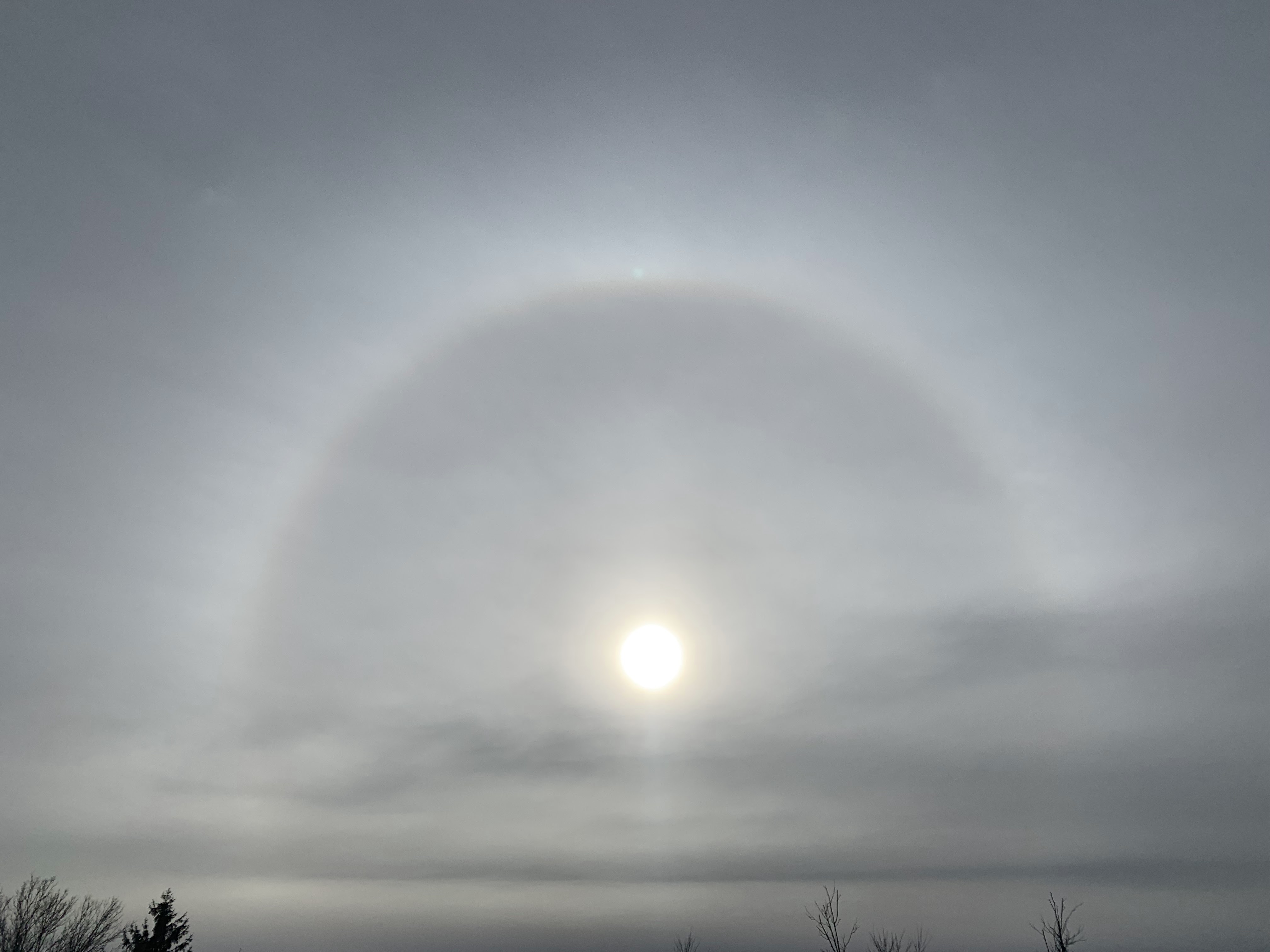
A halo around the sun as clouds increased ahead of tonight
storm. Photo taken a little after noon, Colchester, Vermont. 
 All the updated forecasts are in as of 5:15 p.m. Tuesday and we in Vermont are still in for a messy, but modest sized storm.  

The bad road conditions will affect you only if your timing is bad. If you're on the highways between, say 8 or 9 this evening and mid-morning Wednesday, you're kinda screwed. After that, it shouldn't be so awful.

I'm sure you noticed today the sky steadily went from sunny to a dark overcast by afternoon. By 5 p.m. weather radar is lit up with what appears to be precipitation falling in much of Vermont already. 

But that's virga, which is rain or snow that evaporates before hitting the ground. As is typical with a storm this time of year, it's running up against some very dry air. Snow comes out of the clouds, but evaporates in that static cling type of atmosphere.

Eventually, that evaporating snow will moisten the air, and the precipitation will then hit the ground. In Vermont, that will hit probably a little after 8 p.m. this evening in the Champlain Valley and the rest of extreme western parts of the state, and make it to the Northeast Kingdom before midnight.

FORECAST ADJUSTMENTS

The National Weather Service in South Burlington has only made minor changes to the forecast as of this evening. The onset of snow looks to be just a tiny bit earlier than this morning's forecast.

Total snow accumulation along the eastern slopes and summits of the Green Mountains in central and southern Vermont have been pulled back just a tiny bit. 

The big winners down there could see four or five inches of snow. The rest of Vermont along and east of the Green Mountains looks like they'll see 1.5 to 3 inches of snow. Low elevations of southwestern Vermont will probably see one to two inches. The Champlain Valley will get two inches or less.

There will be an interval of sleet and freezing rain thrown in overnight and early Wednesday, just to make things interesting. That's bad for the roads, but it won't be nearly enough to mess with trees and power lines. 

I'm still thinking the morning commute in the Champlain Valley might not be all that annoying. Unless something unexpected happens, I suspect it will be a little above freezing with a cold, non-freezing rain after 6 a.m. 

It'll still be schmutz elsewhere, with mixed precipitation lingering until mid morning. So you'll want to plan your trips to happen Wednesday afternoon or evening. 

Thanksgiving Day still looks great by November standards. We'll have clouds and some hints of sun, with temperatures getting up to the low 40s. Not great, but not terrible, right?

I do see some potential issues for you Black Friday enthusiasts. Another cold front should come through late Thursday night or very early Friday.  That'll drop temperatures, yield some snow showers and perhaps create some areas of slick roads as you make your way to the cold, dark, windy parking lots of the big box stores before dawn Friday. 

(Editor's note: Is it really worth it to get up that early on a Friday to shop amid too-aggressive crowds?)

Anyway, colder than average weather is forecast to continue for the foreseeable future, at least into early December. The weather pattern doesn't really favor big storms, but you never know if a surprise will pop up. 

The next chance of any kind of snow after Friday morning is Monday, but I have no clue whether it will be noticeable or nothing burger flurries. 

Vermont Forecast Still Schmutzy For Tonight, Wednesday Morning

Our familiar National Weather Service/South Burlington
snow prediction map has most of the accumulation
along and east of the Green Mountains tonight
and early Wednesday.
Vermont is still on for weather designed by Sasha Royale Paine Diaz (sound it out) tonight and early Wednesday. 

The good news is it looks like many of us will be at least mostly out of the woods by mid to late morning Wednesday, so people who need to can get on with their travel plans 

It does look like the eastern slopes of the Green Mountains from at least Warren south to the Massachusetts border are in for a White Thanksgiving. 

Those areas can expect three to locally as much as six inches of snow tonight and very early Wednesday before things change over to a cold rain before tapering off. 

Most Vermont ski areas should get a few inches of new natural powder. If I had to pick a ski area that will get the most snow, I'd guess Okemo, near Ludlow. 

The strip along Route 7 from Bennington all the way up to Swanton looks to get off fairly lightly. Those lower elevation areas, including the Champlain Valley can expect a burst of snow tonight, followed by a little mix after midnight and hopefully just plain rain by or even a little before dawn. 

THE SET UP

As expected, this morning was cold. Vermont's first zero degree temperature of the season popped up before dawn today in perennial cold spot Island Pond, in the Northeast Kingdom.  That kind of temperature there isn't all that weird for the third week of November.

Most of the rest of us were in the teens, with colder towns in the single numbers. The low in Burlington was 18 degrees not odd for Thanksgiving week but still the chilliest temperature since March 12. Winter is at least sort of here, for sure. 

We had a rare bit of sun Monday afternoon and today is starting off crystal clear. But satellite images show clouds on our doorstep, and the sun will fade behind those clouds later this morning and afternoon.

Timing wise, the National Weather Service office in South Burlington has snow starting between 8 and 10 p.m. this evening south and west of Interstate 89, and by midnight for most of the rest of the state.

Road conditions will deteriorate pretty quickly in the hours before midnight. So if you're driving somewhere today, try to get there by 8 p.m. at the latest. 

WEDNESDAY

As noted, the "luckiest" people in Vermont will be those in low elevations west of the Green Mountains. There, only an inch or two of snow will fall, and at this point, it looks like temperatures will be above freezing with rain by 6 a.m. That bodes well for the morning commute, though there still will be slush and icy patches to watch out for. 

Also, be careful as conditions can unexpectedly change. There's always the chance the warmer air could be delayed, making a mess of things even in the Champlain Valley. 

Along and east of the Green Mountains, snow and mixed precipitation should continue at least into mid-morning Wednesday.  Travel will be difficult and annoying, and not really recommended in those areas. If you delay your trip some until, say noon, you'll be much better off and less stressed. 

By the way, wind, rain and visibility problems will probably cause at least a few flight delays in the Northeast Wednesday, so check your airline to see if you're actually taking off when you're supposed to. 

Rain and lingering mixed precipitation in the mountains will slowly taper off Wednesday afternoon and evening. 

Thanksgiving's weather is actually the pick of the week. Of course it's November, so you can't expect much. Still, we'll have hints of sun and seasonable afternoon temperatures in the 37 to 45 degree range, so that's not bad. 

The weekend is looking rather quiet and chilly at this point. 


Monday, November 20, 2023

Quick Monday Update: Cold Today, Still Messy Vermont Tuesday/Wednesday

The sun was out as a fairly heavy snow shower approached
St. Albans, Vermont Sunday afternoon. The snow 
shower was brief and left only a dusting of 
snow on the ground. 

UPDATE 5 PM TUESDAY

Winter weather advisories have been posted for Tuesday night and Wednesday morning for areas of Vermont and New York outside the Champlain Valley.

We should see enough snow and mixed precipitation in those areas to really slicken up the roads over Tuesday into Wednesday morning.

The Champlain Valley is also in line for some snow and mixed precipitation, but that will fairly quickly change over to rain late Tuesday night or very early 
Wednesday morning, at least as it looks now. 

There still might be some icky roads in spots even in the Champlain Valley through early Wednesday, so be careful. I'd still advise postponing road trips to later Wednesday morning or afternoon. By then, almost everybody will be just seeing plain rain, and it will be tapering off slowly during the afternoon. 

By the way, this same storm system appears to be creating a tornado outbreak in Louisiana and Mississippi this evening.  There's been very little severe weather in the South this autumn. However, when there's an El Nino, severe weather outbreaks become common in the South. Let's hope tonight's dangerous weather down there is not the start of a trend. 

PREVIOUS DISCUSSION

 I'll just to a quick update today on the upcoming Vermont messy weather, with a lot more details to come in a post tomorrow morning. 

First of all, Sunday was classic Vermont November, wasn't it? The sun would come out, then we'd get a snow shower, more sun, then more snow. With blustery northwest winds blowing the entire time.

A few of Sunday's  snow showers were relatively heavy. Not snow squalls, but enough to leave a dusting of snow in many spots. 

 Snow showers continued mostly in the northern third of Vermont overnight, so there might be some slick spots this Monday morning on the roads.

 It looked like the snow is probably accumulating a little along the western slopes and summits of the Green Mountains early this morning.  

Eventually, today will be cold and dry as previously advertised. The bad stuff comes in Tuesday night and Wednesday. 

I think this will be one of those situations where we'll be telling you right through the event to expect the unexpected.

Broadly, we know snow Tuesday night will mix with and change to sleet, freezing rain and then rain overnight and Wednesday.

When and where the changeover happens will always be tricky. Even during the storm Wednesday morning things will probably be changing quickly from one hazard to another.  The timing of any changeovers will depend on location, and especially elevation. 

I'm guessing the "safest" place early Wednesday will be the Champlain Valley, but even there, roads will probably have their winter issues. 

This won't be a tremendously big storm. But of course those smaller storms are often the ones to watch out for.  It lulls people into thinking it's not that bad out - until they hit that patch of ice. 

At this point snow accumulations will probably be a dusting to four inches. There will be light accumulations of ice here and there. Total precipitation - rain and melted snow and ice, looks to be a moderate third to a half inch, maybe a little more in southern Vermont. 

I'm sticking to what I said yesterday. If you need to travel somewhere on Wednesday, the best bet is to delay it to later in the morning or afternoon.  By then, you're more likely to encounter just rain instead of snow and ice. 

Quiet weather is still in the cards for Thanksgiving Day. 

Confirmed: World Had Hottest October On Record By Wide Margin

 As promised, we now have NOAA's latest temperatures check on the world, this one for October. As I've hinted at previously, October indeed was the hottest on record. 

The National Centers for Environmental Information tell us that October was nearly 0.5 degrees Fahrenheit warmer than the previous warmest in 2015. Half a degree doesn't sound like much, but that's a hugely wide margin when you take in the entire world's data. 

Wildly remarkably, October was the fifth consecutive month to break the record for the world's hottest. 

If you are under 47 years old, you've never seen a global October that was cooler than the 20th century average. The long trend of climate change continues, and has accelerated, at least temporarily.  

The warmest areas relative to average were the Arctic north of Canada and Alaska; most of Siberia and Mongolia, southern Europe, central South America, southeastern Canada and New England. 

 One relatively cool spot on Earth in October was much of Antarctica (which is a good thing, considering how worried we are about massive ice melt down there).

 The only other sort of coolish areas were a part of northern Scandinavia, a small patch of the Indian Ocean southwest of Indonesia, a tiny spot in central Australia and southeastern Montana. That's about it. And those areas were only slightly cooler than the long temp average. 

I've already seen climatologists start to analyze November so far.  While global temperatures aren't trending quite as far above normal as they did in October, November still seems to be in line to become the warmest on record.

This year is so far the warmest on record, according to NCEI. We now have a greater than 99 percent chance of this year being the hottest on record. That would surpass 2016, which came during the last big El Nino.

El Ninos, as I've mentioned so many times I feel like I'm living the movie "Groundhog Day," boosts global temperatures. El Nino works in conjunction with climate change to break many record high temperatures across the Globe. 

Since El Nino is expected to last at least through the winter, expect more global - and local - high temperature records in the coming months. 

Sunday, November 19, 2023

The Vermont Week Ahead: November Annoyances Continue

Norway maple leaves, some still green remarkably remain
on trees in Burlington, Vermont Saturday. Warm nights 
this autumn have kept the foliage on these trees much,
much later than normal. 
Although it's been a relatively chilly Vermont November so far, I'm still struck by the lack of nighttime cold.  

So far this season in Burlington, the coldest it's gotten is 29 degrees.  

The normal low this time of year is 31 degrees, so you'd think we would have had nights colder than the upper 20s by now. For perspective record lows this time of year are in the single digits above zero.

The result is, in more urban areas of Vermont anyway, a few leaves have stuck to some trees.  

Norway maples usually lose their leaves pretty much last of all the trees except larches and Bartlett pears.  But the Norway maple leaves have in the past always been gone by early November. 

Yesterday was November 18 and the leaves are still hanging on, at least around Burlington.  I've never seen anything close to this before. Another albeit minor sign of climate change, maybe?

In any event, this week should get rid of those leaves once and for all. A pretty good cold front today will eventually plunge temperatures into the teens to maybe near 20 by Tuesday morning, so that will bring us toward winter. 

The whole week is setting up to be fairly wintry, as we remain stuck in a cold weather pattern. I don't see any epic storms coming our way, but there will be trouble from time to time. 

Let's break it down day by day.

TODAY: 

I, and the National Weather Service office in South Burlington, noticed some buzz on social media last night of the possibility of snow squalls today, which can be dangerous. 

It ain't going to happen. Take the snow squalls off your schedule today and don't worry about it. It was just the usual social media clickbait and fake news. 

With a cold front coming through today and a generally unstable environment, there's a decent chance of seeing some snow showers around. But they won't be heavy, and might mix with rain in warmer valleys. 

The favored western slopes of the central and northern Green Mountains might see a couple inches out of this, but most of us will see a dusting at best. 

MONDAY:

A cold one to start getting rid of those pesky yellow Norway maple leaves clinging to the trees, preventing you from raking the lawn. If you're in central or northern Vermont, I doubt the temperature will get above freezing all day. For many of us, it will be the first such day of the winter season.  Aside from a few mountain flurries in the morning, we might actually see some sun in the afternoon. Yippee! 

Monday night will be cold for this time of year, as mentioned, with temperatures bottoming out in those teens. Maybe some single numbers in the coldest hollows.

TUESDAY:

Quiet and cold in advance of a messy storm. Increasing clouds, highs in the 30s

TUESDAY NIGHT AND WEDNESDAY

The mess of the week, just in time for Thanksgiving travel.  The forecast details will become clear in the next day or two. But for now, expect a messy mix of wintry crap coming out of the sky overnight Tuesday and likely into Wednesday morning.

Obviously, that means roads could be kind of nasty in the morning.  At this point, it's looking like it might go over to rain in most spots Wednesday afternoon. So if you can delay your trip until then, that might be a good idea.

THANKSGIVING:

Back to quiet and cold with snow showers around. Unless Wednesday's storm somehow gets hung up nearby, there shouldn't be enough so to cause travel trouble.

BLACK FRIDAY

Sorry, but Black Friday is a day I distain.  If you want to wait in a cold, blustery parking lot hours for dawn to grab those so called door buster deals, knock yourself out. Perhaps literally, the way some people behave on Black Friday. In any event, no storms seem likely on Friday. Just snow flurries to give you a bit of holiday cheer of sorts. 

Remember the further out the forecast, the more likely it will change. Expect the forecast for later in the week, especially Wednesday through Friday, to get some updates. 

Saturday, November 18, 2023

Google's AI Weather Forecasting Model Might Improve Forecasts

Old fart that I am, I tend toward skepticism with AI, or to spell it out, Artificial Intelligence.

Google's GraphCast AI weather forecasting model
performs better than current weather models,
according to studies. 
I know that's where we're going and there's certain benefits to the technology, but don't get me started on the downsides. 

However, if I must focus on the positive,  Google has developed some AI technology consisting of a weather forecasting model that experts say could vastly improve predictions. 

For years now,  it seems like every time there's a storm, you hear about the American model and the European model disagreeing on the track and intensity of expected bad weather. Both are computer models of course, with the European model arguably the better of the two.

According to studies, the AI weather forecasting model from Google is a big improvement over these old school models. I guess all roads lead to Google these days. 

According to the Washington Post: 

"Google DeepMind's AI model, named "GraphCast," was trained on nearly 40 years of historical data and can make a 10-day forecast at six-hour intervals for locations spread around the globe in less than a minute on a computer the size of a small box. 

It takes a traditional model an hour or more on a supercomputer the size of a school bus to accomplish the same feat. GraphCast as more accurate than the European model on more than 90 percent of the weather variables evaluated."

GraphCast is actually one of several AI weather forecasting models under development. Government agencies world wide are looking into AI models because they are fast, efficient and can save money. 

As the Washington Post explains, current models like the American and European make forecasts based on really complex mathematical equations that would make anybody's head spin. These models are expensive because they require tons and TONS of computing power.

The AI models work differently. They suck up pretty much all the historical weather data available, then generate forecasts by looking at current conditions and figuring out what will happen next based on that historical data.

In a sense, AI weather forecasting models are old school.  In addition to relying on computer models, many human meteorologists often compare historical weather events to what's going on now to help them predict what the weather will be like tomorrow. 

One question about AI and weather forecasting is its ability to forecast extreme events.  There are not many super wild weather events from the past from which AI can "learn" about and then project into the future.  

This is especially true in our age of climate change, considering that we're seeing more and more record storms, record temperatures and weird storm behavior. 

However, GraphCast performed well in these event. Says the Washington Post: 

"GraphCast reduced cyclone forecast track errors by around 10 to 15 miles at lead time of two to four days, improved forecasts of water vapor associated with atmospheric rivers by 10 to 25 percent, and provided more precise forecasts of extreme heat and cold five to 10 days ahead of time."

However, questions remain as to whether GraphCast and other AI models can accurately forecast small scale weather trouble, like severe thunderstorms, tornadoes and localized flash floods. We also don't know how well AI does with larger storms that produce heavy precipitation in one area, but light rain or snowfall just miles away. 

That's particularly important here in Vermont. The most dangerous weather in the Green Mountain State include flash floods roaring out of the mountains;  downslope winds during winter storms that can be destructive in one town and no big deal the next; and nor'easters that can dump a couple feet of snow in say, Ludlow, but just a few inches up the road in Rutland.  

The Washington Post also cautions that AI isn't going to replace traditional computer models, or human meteorologists for that matter. At least not right away. Traditional models offer the initial conditions that AI uses to project the future. Also, the old computer models are still necessary to "teach" AI how to interpret historical weather. 

Also, it'll take real-life meteorologists to transmit what AI is telling us what will happen into the Plain English we need to know whether to take an umbrella with us tomorrow.  

 Some of the headlines are already overblown on the idea of AI "replacing" meteorologists. The headline about GraphCast Tuesday in Gizmodo was "Google's New AI Weatherman Will Leave Forecasters In The Dust."

Read the actual Gizmodo article and you discover, not quite. As that article states, "The study authors say their work is meant to work alongside the standard systems meteorologists rely on."

So AI isn't going to chase away your favorite meteorologists like Al Roker, Jim Cantore, Ginger Zee or local Vermont favorites like Gary Sadowski, Tyler Jankowski or Mark Breen.   

If it all works out, AI will be another tool these meteorologists use to give us their most accurate forecasts.  I'd hate to see our forecasts just coming from some sterile machine.  I need the human touch when I'm being told how much snow I'm going to have to shovel from my driveway. 

I just hope the bean counters at major media outlets don't think they can fully replace humans. Because they can't.