
Saturday, May 28, 2022

The Hero Lilac

The big lilac in front of my house put on a huge, aromatic
show this spring, infusing me with a bit more confidence
in the rest of the garden season. 
When I bought my house back in November, 2007, the place was a wreck.  

Before me, it had been owned by - no lie - a schizophrenic pot dealer with a penchant for guns and a huge overestimation of his plumbing and electrical skills.  

But I needed a bargain fixer upper and this was my ticket. 

The house had good bones, though it was a wreck. The plumbing leaked, the electrical system was about as far from code as you could get. The property comprises an acre, all overgrown with weeds, dead shrubs and tangles of wild grapevine. 

However, I envisioned a place that would eventually become a paradise, a comfortable home with beautiful gardens where a weather geek like me can watch and measure the change of seasons, the pluses and minuses of Vermont weather, and for better or worse, changes in the climate.

Thanks to my husband Jeff and his exquisite design vision, the house is now gorgeous. (Bonus: Also safe and up to building code standards).And because of my love of playing in the dirt, the gardens aren't too shabby. 

This process from beast to beauty has to start from a place of potential. The house was just a simple rectangle, a blank slate on which Jeff could work his magic. 

The property had pieces that promised beauty, too. The back yard has three enormous poplar trees, The Triplets as I call them, that anchor the back yard gardens.

When I bought the house, there was a large but battered lilac bush out front just begging for some TLC.

I'm a Vermonter, and I know it's sacrilegious to destroy a lilac. And this old lilac had potential, like the rest of the property. Lilac and I were fast friends.

I quickly tore out all the dead limbs and stems. In December of 2007,  pruned the tangles. Contained the tendrils running out toward the drive. Lilac rewarded me in May, 2008 with gorgeous blooms and hasn't let me down since.

Except for one incident that wasn't Lilac's fault. I'll get to that in a bit. 
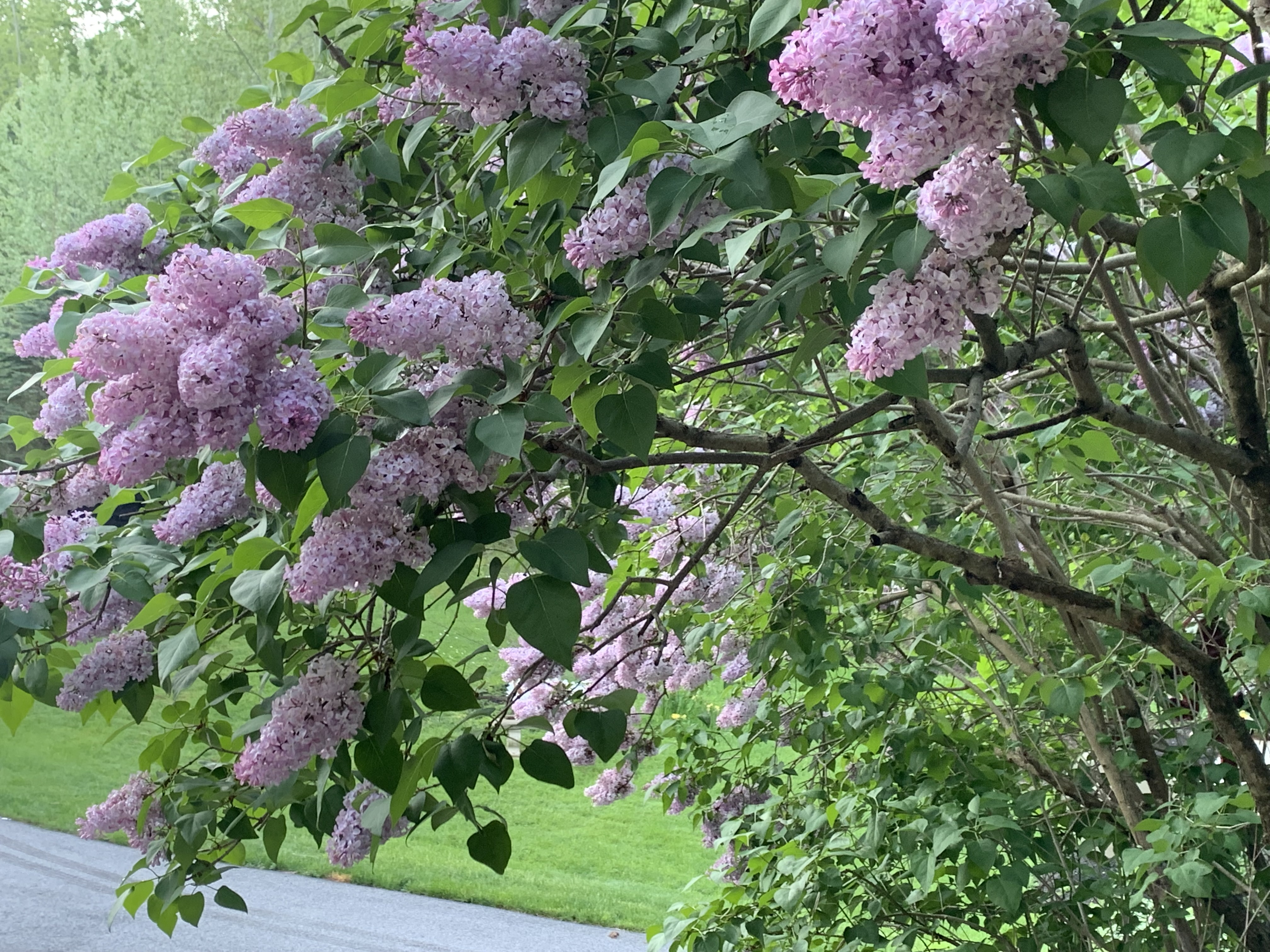
Blooms on my lilac were so profuse the branches sagged,
leaving me with this gorgeous view at my front door

Lilacs are tough old birds. They'll survive just fine for decades after the house they were near has long since disappeared. So I learned never to worry about Lilac. This guy fights back. 

In April, 2010, we had an early spring. By the last week of the month, Lilac had leafed out and had plenty of flower buds. Then on April 27-28, thirteen inches of snow flattened twelve-foot-tall Lilac to the ground. 

Then it thawed and Lilac sprung back almost as if nothing had happened. I had to remove one relatively minor branch that had cracked. 

Lilac became my measure of how late or early spring was. Lilac bloomed spectacularly by the first of May, 2012, the earliest I'd seen that happen. It was a remarkably warm spring. It ran a little late in May, 2014 after a cool spring. 

But Lilac was always reliable.

Maybe it's a sign of how off the rails the climate has gotten, but last year was the first time I've seen Lilac's spring glory diminished by goofy weather. 

Spring, 2021 was very early, almost as early as 2012. The florets were budding and growing by April 20. Then, on April 21-22, it snowed.  No problem, Lilac has proven it can handle that. Then, with temperatures in the 20s, roaring northwest winds and snow squalls ripped through during the morning and early afternoon of April 22.

That managed to kill many of the florets on Lilac.  It subsequently bloomed a little bit, but the show was very much diminished last spring. It made me wonder a little bit if gardening is even worth it. If climate change can diminish tough Lilac, what will it do to everything else, eventually. 

Apparently, Lilac wants me to buck up.  This year, another early spring, but not as early as last year arrived. There was one scare of sorts with another super heavy, wet snowstorm on April 19 that weighed down the branches, but that ended quickly with no problem.

The blooms this year were more than I've ever seen. Everyone in Vermont appears to have had a great lilac year, but Lilac by my house outdid itself. You can scarcely see any leaves, the blooms were so profuse. The branches were so heavy with blooms they sagged almost to the ground. 

Talk about encouragement! The breeze blowing the aroma of the lilacs through the house was enough to snap me out of my negative mood.'

A too-early bout with heat and humidity (yay, climate change again) made the lilac show come and go faster than usual. The blooms have faded now, but they did their job. 

Yes, I'm way behind on gardening this year.  But I can go forward with confidence, with Lilac's spring blessing. I don't know what kind of setbacks I might suffer this summer, - drought, floods, severe windstorms, spongy moth caterpillars - who knows? 

In the age of climate change, you need any type of confidence I can collect. 


Ch-Ch-Ch-Changes Goes The Song, And The Forecast

Plants on my St. Albans, Vermont deck and the surrounding
trees got a drink of water this morning. Elsewhere in
Vermont, rainfall last night was less than most expected
 Most of Vermont had a disappointing amount of rain yesterday and last night.  We pretty much threaded the needled between a zone of rather heavy rain in northern New York last evening, and some robust thunderstorms down in the lower Hudson Valley and southern New England. 

Burlington only managed 0.07 of an inch, and Montpelier got nothing. Just the far northwest corner of the Green Mountain State received anything decent. 

My rain gauge is inaccurate and I have to get a new one, as it said I had an inch of rain. Judging from the amount of water outside my house, I'd guess precipitation was closer to half an inch. 

If you need rain, the good news is a little more is probably coming today, though it doesn't look like much.  And that hot, dry spell that had been forecast for this upcoming week is looking less hot and less dry. 

In general, most of today's showers will run from now until early afternoon, and then start tapering off northwest to southeast. It looks like most of us will see a quarter inch of rain or less, but as always, there might be a locally heavier downpour or two.

Tomorrow and Monday are still looking gorgeous. It'll be cooler and less humid tonight, and warm but not humid Sunday.  Monday's humidity will be reasonable. 

It's now looking like Monday might be the warmest day of the week. Heat and humidity had been in the forecast for most of the upcoming week, but it now looks like a wrong way cold front coming in from the northeast will win out. 

That means it will still be seasonably mild, with maybe highs in the 70s to perhaps around 80 southwest. 

This arrangement will open the door for weather disturbances to scoot down on us from the northwest.  That puts the chance of showers in the forecast Tuesday through Friday. 

I'm not impressed by the amount of rain coming up, and it certainly won't rain all the time. But the chances of showers and some clouds around will keep us from drying out too quickly. 

Looking ahead, the first 10 days or so of June are looking cool and somewhat showery as well. 

Friday, May 27, 2022

Gusty Winds Thursday Introduced Rainy Vermont Period, Things To Improve Sunday

Trees bend in the wind Thursday evening in St. 
Albans Vermont. Some gusts Thursday reached 40 mph
 I was pretty impressed by some of the wind gusts yesterday, as they were pretty strong for this time of year.   

Normally, we only see gusts in the 30 to 40 mph or more range during strong thunderstorms this time of year.   Non-thunderstorm winds like Thursday's are usually creatures of late fall, winter and early spring. 

Burlington managed a gust to 44 mph, the highest reported in the area so far, but many places were in the 35 to 40 mph range. Leaves on the trees this time of year make them more prone to snapping, and I did see quite a few branches and a couple of trees down in my wanderings on Thursday. 

The wind has died down, and this morning, we've dealt with some light showers, at least in northern areas. 

As expected, we're going to deal with a couple not so perfect late spring days. But the rain is always welcome. It's coming at just the right time to wet down the gardens after a few dry, breezy days. 

It's possible a few storms this afternoon could get on the strong side, but the the risk is marginal at best. We could also see some locally torrential downpours late today and tonight, but again, the risk of any flooding is very low. 

The real serious part of this storm system is hitting the Mid-Atlantic States. There's been a tornado watch since early today in part Virginia, North Carolina and Maryland that's in effect until at least 2 p.m. today. The same areas could see some flash floods as well. 

It's a sluggish storm system, as previously advertised, so showers should linger through much of Saturday. It appears that the air will be unstable enough for renewed showers and maybe some rumbles of thunder  to re-blossom in at least parts of Vermont during the afternoon. 

Sunday is still looking gorgeous with sunshine and reasonable humidity levels.

That hot spell for next week is looking less hot and a bit less humid as well. It will still be very warm for this time of year, and the humidity won't be exactly low. The ridge of high pressure causing the toasty weather is expected to set up shop a little further south than first thought. 

This readjusted setup will allow disturbances riding up and over the ridge to skirt just to our north, which offers the chances of a few showers and storms in northern Vermont by midweek.  The ridge will be starting to break down around Thursday, to allow more showers and maybe storms to move in by then.  


Thursday, May 26, 2022

Memorial Day Weekend To Match Holiday's Weather Reputation

True to form, this Memorial Day weekend will re-introduce
us to summer. It will start rainy, and end sunny and warm.
If you do end up out on the lakes Sunday or Monday,
remember the water temperature is still quite cold
so be careful and don't fall in! 
Memorial Day weekend is regarded as the unofficial start of summer. Here in Vermont this year, it will also mark the re-start of summer 2022.  

The weekend will start out rather wet and not beach friendly.  After a few coolish days this week, the holiday weekend will end with a return of warm, humid weather. How warm it gets depends on the actions of a potential "wrong way" cold front. 

If you looked at the weather radar this morning, you'd think we're getting a soaking rain. However, we were seeing pretty much nothing more than sprinkles out there early this morning. Rain is falling into dry air, so it's mostly evaporating on the way down. The little disturbance causing this will move on this afternoon, and we'll end up with a partly sunny, windy afternoon.

Next up, we actually will get some rain.  We should hope we get a soaking, as this will probably be the last rain for awhile, as we seem to be getting ready to enter another multi-day dry spell. 

The bulk of the rain will come between Friday afternoon and Saturday morning, as that's when the best moisture will be in place with the storm system coming in from the Midwest. Current expectations are we could see a half inch to three quarters of an inch of rain from this. So nothing extreme. 

We could also see a few rumbles of thunder in spots and some locally heavy downpours, but again, nothing too scary.

One aspect of this mid-sized system that is a sign of summer is it's forward speed. It's sluggish. It'll linger most of the day Saturday, keeping us under risk of showers. Still, the afternoon and evening will begin to dry out a bit, at least in northwestern sections. 

That's still better than the Saturday of Memorial Day last year.  It actually snowed in the high elevations of southern Vermont. Northern Vermont had clearer skies and a somewhat warmer afternoon than the south, but the north had scattered frost at night. 

No such worries this year 

Sunday at this point is looking nice, with sunshine and temperatures in the mid and upper 70s for highs. Humidity will be reasonable. Which is all good for the Vermont City Marathon in Burlington.  You don't want a lot of heat and humidity for the runners.

Not to worry, though, if you like summer weather, the final day of the Memorial Day weekend brings it on. By Monday afternoon, it will at least in the low 80s for most of us.  We've already had a couple spells of true summer weather this month, and it looks like we're about to get another one as May ends and June begins.

Next week looks like we'll have daily highs in the 80s with somewhat muggy nights and moderately humid afternoons.  Rain chances look low, too.

The only wild card is a possible back door cold front. It's called back door because most cold fronts come at us from the west or northwest.  This one, if it makes it, would come in from the northeast. 

If this "back door" cold front makes it, things will be slightly cooler than current forecasts, but still on the warm side for this time of year. Again, if this front makes it, the better chances of slightly cooler weather would be east of the Green Mountains. 

Wednesday, May 25, 2022

NOAA Agree: Hurricane Season To Be Busy Again This Year

Hurricane Ida on approach to Louisiana last year. 
NOAA is predicting yet another busy 
hurricane season for 2022.
 NOAA weighed in with their seasonal hurricane forecast for this year, and they agree with pretty much everyone else: We're in for another busy hurricane season.  

NOAA does this in percent chances.  They tell  us there's a 65 percent chance of a busy season, a 25 percent chance of near normal activity and only a 10 percent chance we'll have fewer than average tropical systems this year. 

If this hurricane season is busier than usual, it will be the seventh such season in a row. 

Like all hurricane forecasts, NOAA doesn't really get into how many of these storms will hit the U.S. coast. That's awfully hard to predict until you have an actual hurricane out there to track. But it's all a matter of chances.

The more tropical storms and hurricanes you have buzzing around out there, the greater the chance at least a couple of them would splash ashore in the United States.

Here are a few more details from NOAA:

"For the 2022 hurricane season, NOAA is forecasting a likely range of 14 to 21 named storms (wind of 39 mph or higher), of which 6 to 10 could become hurricanes (winds of 74 mph or higher), including 3 to 6 major hurricanes (category 3,4 or 5; with winds of 111 mph or higher). NOAA provides these range s with a 70 percent confidence."

Reasons for the expected busy hurricane season include the following:

La Nina: A periodic cooling of the eastern Pacific Ocean is continuing this year. This tends to weaken upper level winds over the Atlantic Ocean.  With these weaker winds, clusters of thunderstorms that want to be tropical storms stand less chance of getting blown apart before gaining momentum into an organized hurricane

Water Temperatures: Water temperatures in much of the Atlantic Ocean, Caribbean and Gulf of Mexico are above normal.  The warmer the water, the more fuel for wannabe tropical storms. 

African Monsoon: Central and western Africa are subject to a series of wet storm systems during their seasonal monsoon in the summer and early autumn.  These disturbances move off the west coast of Africa and can become hurricanes. This monsoon activity is forecast to be above normal this year.  

Climate Change: The exact role climate change has with hurricanes is still being studied. But some indications are that the warmer ocean waters can contribute to more such storms. The warmer water might also enable hurricanes to form further north than in the past. 

Or, hurricanes coming in from the south will be able to maintain their strength longer as they move over what used to be cold water, but is now warmer due to a changing climate. 

Hurricanes are not just a coastal problem. They can
cause catastrophic flooding well inland after their winds 
have died down.  This is a Vermont house destroyed
by Hurricane Irene's flooding in 2011.

NOAA's hurricane forecast is consistent with other forecasts. The closely watched Colorado State University hurricane forecast, for instance calls for 19 named storms, against an average of 14.4 such storms each year.

The Colorado State University forecast also predicts four major hurricanes this year, in line with NOAA's estimate.

Keep in mind that if a hurricane smacks into a distant coastline, it can still be your problem. We saw a classic example of that last year after Hurricane Ida slammed into Louisiana. A few days later, its remnants unleashed catastrophic flooding in New York City, New Jersey and some surrounding areas.

Winds with hurricanes die out pretty quickly once they reach shore. The torrential rains can last a lot longer. Climate change gives that a boost because warmer air can hold more tropical moisture than cooler air. Which can make the remnant downpours from hurricanes that much worse. 

Hurricane season for the Atlantic Ocean starts June 1 and continues through November. You can see tropical storms outside that season, but they are relatively rare. At the moment, there's no signs of any tropical systems trying to form. Give it time, they will. 

Tuesday, May 24, 2022

Not Everybody Gets A Warm Spring; PAC NW Having Winter In May (Almost)

While we in Vermont have had a generally warm spring
with a couple snowy exceptions, the Pacific Northwest has
had a wet, cold, miserable spring. Photo above from KOIN
shows a Portland neighborhood enduring its first
April snowstorm on record back on the 11th of that month
Despite the chill we felt this morning around Vermont, we have had a relatively warm spring.  We've even had a few premature bouts of summer weather so far this month. 

There's actually a chance we might score into the top 10 warmest Mays, depending on how the weather shakes out in the final week of the month. 

Not everybody gets to enjoy such warm weather. The Pacific Northwest, in particular, has had a miserable spring. 

In Seattle, April was a substantial 4.2 degrees cooler than normal and so far May in Seattle is running at 5.5 degrees below normal. They've dealt with extra clouds and rain, too. So far this month they've had 3.18 inches, more than double the amount they should have gotten by this point in the month. 

Portland, Oregon, had the first April snowfall on record on the 11th and 12th of the month.  Since many trees had leafed out by then, there was plenty of damage. The month ended up being 3.1 degrees colder than average.

Portland also had its wettest April on record, with 5.73 inches of precipitation (Normal is 2.89 inches).

Things aren't much better in May for Portland. The month so far is running 3.2 degrees chillier than average and rainfall is running an inch ahead of normal. 

Further east, places like Denver, Boulder and Colorado Springs are having a spring with temperatures averaging fairly close to normal. But even there. a late season snowstorm dumped several inches of slush on those cities.  Trees were leafed out there, too, so many branches collapsed onto wires, causing 100,000 people to lose power.

Prospects seem bleak for a warmup in the Pacific Northwest. The long range forecast for the next two weeks calls for cooler and wetter than average conditions in those areas.

By contrast,  the admittedly not completely reliable long range forecasts has Vermont with mostly warmer than average weather with near normal precipitation for the next two weeks. 

The cold weather in the Pacific Northwest shows that even with climate change, you can get spells of chilly, dreary weather. Cold snaps don't become impossible with climate change, they just become somewhat less likely.

Monday, May 23, 2022

Storms Unexpectedly Avoided Vermont Sunday; Meanwhile Canada Deals With Sat. Derecho

Chaotic looking clouds, but no real storms over 
northern Vermont Sunday. Despite forecasts, there
was a lack of severe weather in Vermont Sunday.
 It really did seem like Vermont was primed for severe weather on Sunday. As we all know, that didn't happen. 

An interesting part of this is that the storms were expected to be most focused in northern Vermont.  Instead, most of the activity that formed was south and east of us in the Hudson Valley of New York, southern New England and the Middle Atlantic States.

Maine also experienced some activity. 

A map of storm reports from Sunday shows almost nothing in northern New England, where the bulk of damaging storms was forecast. 

I am puzzling a bit over the lack of storms, though I have some ideas. First of all, we should be happy there weren't severe storms, as who wants to deal with the damage and problems they cause?  But still, the forecast was wrong, and I'm sure local meteorologists are analyzing why. 

I have training in meteorology but am not a full-blown meteorologist, so I tend to defer to the experts.  One thing I noticed late Sunday morning and afternoon was that the clouds that were in the sky had a sort of "stable" look to them, like there wasn't anything triggering a lift.  It made me wonder a little if the predicted storms would develop. I guess my gut was right in this instance.

I didn't mention this in my updates to this here blog thingy Sunday, as I didn't want to contradict the messaging coming from real meteorologists. Adding my doubts to a volatile forecast would have been confusing to readers. And perhaps some people would have let their guard down if I expressed my doubts. Then, had severe storms developed, there was a chance that whoever read my posts might be unprepared. 

Anyway, the rest of the ingredients were there. It was quite humid, as we well know. A cold front was approaching, which would have created lift in the atmosphere, creating that severe weather risk.

The thinking was a line of storms would form just ahead of the cold front, with renegade strong storms out ahead of it.  

The blue and occasional green dots on this map indicate
reports of severe thunderstorms Sunday. Note that northern
Vermont and New Hampshire, which were considered
the most likely target for severe weather Sunday,
had no reports of damaging winds or big hail

That is precisely what tried to happen. I saw pop up showers on radar quickly form in Vermont, mostly along the west slopes of the Green Mountains and then race eastward. But they didn't grow into severe storms and sort of just petered out on their way toward the Connecticut River Valley. 

Strong winds aloft can make thunderstorms worse. But under certain conditions, the strong winds can rip the top off thunderstorms, stopping them in their tracks. I wonder if that was part of the problem with Sunday's situation.

Meanwhile, that expected line of storms sort of, kinda formed in New York and crossed into Vermont in the late afternoon and evening. But there was no lightning and the showers were wimpy.  The line of basically sprinkles did produce a gust front with winds of 30 to 35 mph.

You might have noticed it turned a bit hazy during that period of northwest wind gusts. That was sort of a pollen haboob.  The gust front blew tons of pollen from trees and other plants.  Allergy sufferers in northern Vermont must have had a rough Sunday evening. 

I think this line of wannabe storms didn't materialize into something strong because stable air was running out ahead of the actual cold front, which was right behind this little gust front thingy.

On the bright side, the forecast for the today and tomorrow is easy. Just nice. High clouds might dim the sun at times today, but it will be refreshingly cool and dry, with highs in the low 60s.

The coldest hollows of the Northeast Kingdom and Adirondacks are at risk for some frost tonight, but the vast majority of us will be fine, garden wise. Tomorrow looks nice, too, with highs a little warmer, approaching a near-normal 70 degrees or so.

CANADA DERECHO

We in Vermont really dodged a bullet Saturday. True, there were some severe storms around. However, a deadly derecho in southeastern Canada missed us by a mere 100 miles or so. 

The derecho, which swept across some of the most populated regions of southern Ontario and Quebec, killed at least 8 people and caused widespread damage.  At least a half million people lost electricity. The storms were so powerful that some large metal transmission towers toppled in the winds, which gusted as high as 85 mph.  

Trees bend in hurricane force winds in this screen grab
of the derecho in Ontario Saturday.

The derecho originated in Michigan and swept through the Toronto metropolitan area and then on to Ottawa.  It weakened somewhat by the time it reached Montreal and Quebec City, but was still powerful enough to cause damage there. 

As in many derechos, the damage was concentrated in some towns while others got off with relatively light damage. The town of Uxbridge, north of Toronto, and Clarence-Rockland, east of Ottawa, suffered considerable damage to buildings, to the point where a number of homes in those communities are too damaged to be occupied.  

It might take a week or more to get power back to everyone in the derecho zone. 

Videos. As always, if you don't see the image of the video on your screen, click the hyperlinks. : 

The derecho sweeps into downtown Ottawa:


The title of this video is "Ottawa Rain Storm"  You're telling me!