Saturday, December 9, 2023

Stunning Light Pillars Light Up A Cold Vermont Night

The National Weather Service office in South Burlington
Friday posted this incredible photo of light pillars
at Jay Peak Resort. Cold, calm weather helps
create this relatively rare phenomenon.
 The National Weather Service office in South Burlington on Friday posted a spectacular photo of light pillars before dawn Friday at the Jay Peak Resort.   

As you can see in the photo, street and parking lights, outdoor security lights and such formed narrow, towering beams of light that looked like a strange impressionist painting.  It looked like some sort of freaky laser light show.

So why did ordinary outdoor lights go haywire on a chilly December pre-dawn?

The lights were fine and working as designed. It turns out a certain type of ice crystal that forms on very cold nights created this relatively rare phenomenon. 

 According to Science ABC:

"These plates of ice crystals orient themselves hexagonally as they drift down through the atmosphere. Their collective surfaces act like a giant mirror that reflects the light falling on them. The light being reflected will extend to a certain distance both above and below the light source. The denser and larger the ice crystals, the more pronounced this effect becomes.

The angle of the ice crystal surfaces will deviate a few degrees from the horizontal orientation, which causes the light pillar, as it elongates the reflection of light. Thus, these phenomena usually appear as columns of lights to an observer."

We get lots of cold nights in Vermont during the winter. As you've guessed, this type of cool light display can only happen under certain conditions. First of all, winds need to be pretty much calm. Wind would disrupt the reflection of light. 

Usually, cold air is pretty dry, but it does contain some moisture, certainly enough for the ice crystals to form. To help with the moisture supply, there was a temperature inversion over Vermont early Friday. 

The inversion, in which a layer of warm air rests atop cold, dense air near the surface, forms a lid.  Moisture from the ground, exhaust from chimneys and cars, and evaporation from rivers and streams probably added to the moisture content of the air. 

Light pillars were also seen elsewhere in Vermont Thursday night and Friday morning. Some spectacular ones were spotted in Barre, for instance. 

Most winter nights don't feature light pillars. But if you want to try hunting then down, they're most likely well after sunset, and often in the pre-dawn hours when winds are lightest.


Saturday Morning Vermont Storm Update: Confidence Increasing With Heavy Snow Forecast; Flooding Still In Play

Saturday morning's snow prediction map from the 
National Weather Service office in South Burlington.
Expected totals have noticeably increased in
the Champlain Valley compared to previous forecasts.
 I'll start with the bottom line: That long-awaited storm Sunday and Monday now seems more certain, with the flood risk Sunday night transitioning to a nasty snowstorm, at least for many of us in the Green Mountain State.  

Forecast models, which were kind of all over the place Friday evening, have gotten their ducks more in order. Though some surprises with the upcoming storm are inevitable, confidence is definitely up on the rain and snow scenario.

Expect some flooding, and a horrible, snowy, windy Monday, especially north and west. 

Let's break it all down step by step:

BEFORE THE STORM

The Champlain Valley really warmed up overnight, rising through the 30s to reach the low 40s this morning. Highs should flirt with 50 degrees this afternoon. Eastern Vermont is cooler, near freezing, but they should get to around 40 later today. 

All this is getting the ball rolling for snow to begin melting in the mountains. Today is an excellent day to stock up on groceries, LED candles and such and do other errands. You might need these supplies by Monday. 

The warm air will continue overnight tonight and Sunday, and the rain will move in during the day. 

THE RAIN/FLOODING

The rain might start out showery on Sunday amid temperatures in the 40s to low 50s, but it will grow steadier and heavier as the day and evening wear on.  The rather heavy rain will continue into the wee hours of Monday morning before the snow arrives - which I'll get into in a bit.

All rivers in Vermont will see sharp rises, and minor flooding is likely anywhere. The rivers most likely to spill over their banks continue to be the Winooski downstream from Montpelier, the Mad River in central Vermont and the Otter Creek in Rutland and Addison counties. 

Southeastern Vermont has probably a higher flood risk than other areas because the rain there will last quite a bit longer before the changeover to snow.  Still, the entire state of Vermont is under a flood watch from Sunday afternoon through Monday afternoon.  

Note that it will have been snowing for hours Monday morning with a flood watch still in effect. That's because it will take time for runoff to reach larger rivers. Flood crests should come Monday morning or afternoon.    

It continues to look like any flooding will be much less serious than what we had in the summer, but expect some road closures in low lying areas, wet basements, standing water on roads and maybe some urban street flooding here and there. 

WET, NASTY SNOWSTORM

The biggest question marks with this storm has been how much snow will fall. We still have some disagreements in the various forecasts, but the range of possibilities has narrowed. And not in a good way. 

The winter storm watch remains in effect generally for northern and central Vermont. The big change in the forecast is that winter storm watch has been expanded to include the Champlain Valley from about Charlotte north to the Canadian border (It will also end up being unpleasantly snowy south of Charlotte, too.

The storm that will form along the cold front will be oriented such that it will easily be able to funnel cold enough air into the Champlain Valley to produce four to 10 inches of heavy, wet snow. That's a change from the previous two storms, which spared the Champlain Valley. 

Elsewhere across northern Vermont, six to 10 inches of snow is in the cards, with locally up to 18 inches in the mountains. Southwestern Vermont is in for two to four inches, with more in the mountains. 

The only place in the Green Mountain State that looks like it will be mostly spared is the Connecticut River valley floor from about White River Junction south.  Those places should only get a dusting to three inches of snow. Amounts will go up pretty fast as soon as you start climbing the hills west of the Connecticut River valley. 

This still looks like it will be a wet, heavy snow, with temperatures in most areas around 32 or 33 degree during the heaviest snow.

As it looks now, the rain will change to snow before dawn in all but southeastern Vermont. The heaviest snow will probably fall during the Monday morning commute. It's going to be a huge mess. Snow could be coming down at a rate of an inch per hour, which makes it hard for snow plows to keep up. 

Wet snow is worse to drive on as it tends to compact into ice. If you can work from home Monday, do that. We'll probably have lots of school closings, so pay attention to that.

With the heavy, wet snow falling and winds increasing, power outages will be a problem. Green Mountain Power is already warning people to stay away from fallen wires or collapsed trees or branches that might have live wires in them. 

I give this storm a high potential to cause even more outages than the 16,000 outages that occurred on December 4 and  34,000 that occurred on November 27 during two previous wet snowstorms. 

I think road conditions will remain bad throughout Monday, but start to improve at least a little toward the end of the day as snow tapers off. Strong winds will continue even after the worst of the storm is over. That means snow loaded trees will probably continue to collapse onto utility wires into Monday evening 

On the bright side, ski areas and other winter sports areas in northern and central Vermont that lose their snow in the thaw Sunday and Sunday night will get most of their snow back Monday. Southern Vermont ski areas will get snow, but it won't be a gigantic dump.

There will be changes to this forecast, so as always, I'll provide updates. 


Friday, December 8, 2023

Friday Evening Update: It's Getting Real: Flood and Winter Storm Watches Now Up In Vermont For Possibly Serious Storm

The National Weather Service in South Burlington has 
greatly increased expected snow totals from the 
Sunday/Monday storm. Click on the map to make it
bigger and easier to see. Take the map with a grain of
salt. Big changes in the forecast either way are still likely,
 Like the headline says, this is getting real. 

It's beginning to look like this will be one serious storm hitting Vermont. Heavy rain, heavy, wet snow, wind, power outages, travel disruptions and more are all in the cards. If the forecast holds, this will really be a nasty one.  

A flood watch is now in effect for all of Vermont, covering the period from about noon Sunday to noon Monday. Flood watches are also up in most of the Northeast from Delaware to Maine. 

A winter storm watch is in effect for northern and central Vermont outside the Champlain Valley and in the Adirondacks for late Sunday evening to Monday evening. 

 It's beginning to look like the snow threat is more dire than the flood threat. But you still have to pay attention to the flood issue. 

With that list of problems, let's take 'em one at a time. 

FLOODING

While other parts of the forecast keep shifting, the rainy part of all the predictions remain consistent. Rain will move into Vermont during the morning or early afternoon in Vermont and pick up in intensity toward evening. 

It'll be warm, with highs in the 45 to 52 degree range, and humidity will be high for this time of year. That'll get the high elevation snow melting pretty fast. 

As we head into Sunday evening and night, it'll stay warm. The rain will come down pretty hard, with maybe a few periods of bonafide downpours as a cold front nears and crosses Vermont.

Rivers statewide will rise sharply overnight Sunday into Monday. The larger rivers will keep rising even after Monday's changeover to snow, which I'll get into shortly. 

Most rivers in the Green Mountain State will at least get to bank full.  Rivers most likely to go into minor flood are the Winooski and Mad rivers and the Otter Creek. 

The National Weather Service and the USGS has the 
Winooski River at Essex Junction going solidly into at 
least minor flood stage by Monday morning. 

At this point, the Winooski looks like it might not reach flood stage at Montpelier. Even if it does, it won't attack downtown Montpelier like it did in July, so we're good there. Toward Chittenden County, the Winooski River is expected to solidly go into flood stage.

For Monday commuters, forget North Williston Road. It will likely be under water and closed. It's possible water could cover Route 2 in Jonesville and possibly Bridge Street in Richmond. Again, this won't be nearly as bad as July, but it's worth noting. 

Low lying roads in Warren, Waitsfield and Moretown could go under water due to Mad River flooding late Sunday and Monday. Same is true for roads right along Otter Creek in Rutland and Addison counties. 

Since it's always dark this time of year, flooding is especially dangerous, as you often can't see flooding ahead of you as you're driving until it's too late. So be careful

SNOWSTORM

The forecast continues to look nasty for a changeover from rain to heavy snow.

This could be a real, big mess. I'll repeat myself, the snow end of this storm might well be worse than the flood portion.  

At this point, anyway, heavy wet snow could amount to five to 10 inches in the winter storm watch zone, with 12 to 18 inches possible in the mountains. Winds will be increasing during the snow, which would really make the power outages worse. 

As for the Champlain Valley, I still have no idea if we will have a lot of snow on Monday or just a little.

The heavy snow will come courtesy of a likely "bomb" storm that will form near the Middle Atlantic States and move northward into eastern New England. Storms are centers of low atmospheric pressure and generally speaking, if the central pressure of a storm is falling, that storm is strengthening.

If the central pressure falls at least 24 millibars within 24 hours, it's a bomb cyclone. When a storm is "bombing," it more often than not causes severe rain, snow and/or wind. 

The National Weather Service office in South Burlington explains this afternoon that computer models indicate the cold front will come through a little sooner than originally forecast Sunday night, and our storm will move northward a little further east than first planned.

That sets Vermont up for particularly heavy snow.  

That said, there's a chance I'm hyperventilating for no reason. I guarantee changes to the snow forecast, and meteorologists really have no idea how much snow will actually fall. The current forecasts are just early guesses.

You can tell how uncertain forecasts are by looking at the National Weather Service probabilities for snow accumulation. For instance, the forecast for Burlington is for 2.9 inches of snow, but there's a chance it could be as much as 10 inches and there's a chance it could be just a dusting.   

There will be short distances as well between areas that get a lot of snow and those that escape. St. Albans, in contrast to Burlington, is set up for 8.3 inches of heavy, wet snow, but it could be as much as 15 inches there or as little as three. 

At this point, anyway, the Monday morning commute looks like it might be a disaster, at least if current forecasts hold. Rain will switch to snow west to east during the predawn hours west, and toward dawn east in Vermont. 

One glimmer of hope: For what it's worth, the Friday late afternoon run of the American computer model makes the storm much weaker and further east than previous forecasts. If that were to happen, this storm wouldn't really be that big a deal. But definitely DON'T count on that. At least until we see more consistent forecasts 

Snow in many areas will coming down at a rate of an inch per hours, which is pretty extreme if you're talking about heavy, wet snow. Drier snow tends to accumulate faster.

Heavy, wet snow is harder to drive through since it compacts under tires into a watery ice, which is as slippery as you can get. Visibility would be terrible too, especially since winds are forecast to get pretty gusty. 

Again, if the forecast turns out as they're thinking now, I would expect a lot of power outages. On Sunday evening, charge your devices and drag out the LED candles. You might need them. Don't use regular candles with real flames. They're a fire hazard. This being the Christmas season, I'm sure you can find some inexpensive and very nice LED candles during any shopping trips Saturday or Sunday. 

Finally, winds look really gusty on Monday, which would make any power outages worse.  Again, we still don't know the strength or position of the storm. This all could be a false alarm, or it could be real trouble. As always, stay tuned. 

Rain Storm And Some Flooding Still In Cards For Vermont, But Another Round Of Heavy, Wet Snow Is, Too

Photo shows heavy, wet snow snarling traffic and 
weighing down trees in St. Albans, Vermont this
past March 14  Changes to the forecast for
the upcoming storm suggest we might see
similar scenes in Vermont Monday morning,
along with some potential flooding.
 
UPDATE 2 PM FRIDAY

The National Weather Service office has - to pretty much nobody's surprise - issued a flood watch for most of Vermont and northeastern New York for Sunday afternoon through Monday afternoon.

The forecast for heavy rain later Sunday still stands. 

The Northeast River Forecast Center forecasts minor flooding for the Winooski and Mad Rivers and the Otter Creek in Vermont. 

All other rivers in the state should see sharp rises, and I wouldn't be at all surprised if other rivers in the state flood as well. 

PREVIOUS DISCUSSION

As we track the nasty storm due to start Sunday in Vermont, we are following the inevitable changes in the forecast.  

One change that's cropping up is that toward the end of the storm, we might have another round of heavy, wet snow that would be enough to cause power outages. 

That would be the third time in a month that has happened. At least if it really does happen.

I've just returned to Vermont from Edinburgh, Scotland, and am greeted this morning by the kind of weather I experienced over there. It's overcast and dreary.  

Some sun might develop this afternoon. But as is typical for this time of year, we won't have much sun. 

Leading up to the storm, today and Saturday will be quiet, and turning warmer. It'll get into the 30s this afternoon, about where temperature should be for this time of year.  Readings won't fall much tonight, and then we'll get into the 40s tomorrow under continued cloudy skies.

THE RAIN STORM

Predictions for the first part of this storm haven't changed much. It will turn even warmer, with highs in the 40s, to possibly near 50 in a couple spots Sunday. Rain will move in during the day. The threat of strong winds during the first half of the storm have diminished, but it will still be breezy, especially in the Champlain Valley. 

That thump of relatively heavy rain will peak Sunday night, as will the rate of melting snow from the mountains. Streams and rivers will rise rapidly, and we're still looking at some minor flooding  Like I have said in previous days, any flooding we do get won't be nearly as serious as what we endured this past summer. 

However, it's basically always night this time of year, and it's harder to see high water on roads up ahead, until it's too late. Some low-lying roads will probably go under water Sunday night and Monday, and if you don't see the water, your car can get caught in that flooding.

The idea of being alone, stuck in frigid water in your car or near it does not sound appealing. Plus, we can't ignore the obvious fact that the cold water could kill you pretty quickly.   

On top of that, there's new forecast complications to deal with as Monday comes along.

SNOWIER FORECAST?

As the National Weather Service in South Burlington points out, there's been some changes to some of the forecasts the computer models are spitting out. 

That wet soggy cold front that is causing the big thump of rain should cross through mostly before dawn on Monday. Meanwhile, the models are suggesting a storm will form along the front somewhere in Mid-Atlantic States.

The more ominous computer models take the new storm northward through eastern Massachusetts and on into Maine, All the while, this fresh storm would rapidly strengthen.

This would keep the heavy precipitation going here in Vermont. The cold air flooding in would change the rain to a wet snow, just in time for the Monday morning commute.

This could be a real mess, given the timing. Since the cold air coming in behind the storm isn't all that cold, the burst of snow would be wet and heavy.  That's the worst crap to drive through. 

On top of that, since the storm would be getting strong, winds from the northwest would howl, perhaps with gusts to 40 mph.  The combination of wet snow piling up on trees with a lot of wind is a recipe for more power failures.

Just what we need, right?  The storm on November 27 cut power to 34,000 Vermont homes and businesses. That got fixed just in time for the storm on December 3-4 to cut power to 16,000 or so Vermont customers.

Now, we have another potential storm to cause similar-sized problems. I'm sure Green Mountain Power and other Vermont electric utilities are just thrilled with this updated forecast. 

This repeated storm damage to electric utilities is expensive to fix. So even if get lucky and none of the storms cuts power to your house, you'll still eventually pay through higher electric bills. Dealing with these storms probably delays efforts by Green Mountain Power to reinforce their grid against increasingly severe storms in the age of climate change.

The early guess on snow accumulations on Monday is perhaps a good thump of six to 12 inches in the ski areas to at least partly replace what is lost in the thaw and rain Sunday night. 

There could be as little as one to three inches in the warmer valleys. But this is just a guess.  I think it will take until Sunday to get a good read on exactly how much wet snow we'll get. Even then, we will probably be in for new surprises with this storm. 

We might have some good news after the storm departs. The weather pattern has been pretty active so far this December, but it looks like a pattern shift might make things go quieter starting next Tuesday. If longer range forecasts pan out, we'll see normal to somewhat above normal temperatures and not much precipitation of any kind into mid-month. We shall see! 


Thursday, December 7, 2023

Upcoming Storm Still Threatening Minor Flooding, Wind, Maybe Late Snow Switch-Over In Vermont

If anything, rainfall amounts in the Northeast have 
increased for the upcoming storm, with two
inches of rain possible in some spots. Flooding
looks likely in Vermont, but it won't be nearly
as bad as the disasters we had this past summer.
Vermont is having a spell of quiet winter cold, but a long-advertised spell of nasty storminess is still on the horizon. And it's still bad news for snow lovers.

If this pans out as forecast, the storm Sunday and early Monday will dump upwards of two inches of rain on at least some of Vermont. That's quite a big amount for a storm this time of year.

Flooding is widely expected with this storm, but at least meteorologists seem pretty confident at this point that it won't be nearly as bad as the inundations we suffered through this past summer. 

Still, I envision low-lying roads closing, some basements flooding, standing water in a lot of areas. Even those minor effects are a pain, especially after the year we had.

Ahead of the storm, a sharp warming trend will begin to stir Friday, then really take hold Saturday. By afternoon Saturday, we should be well into the 40s and the surprisingly deep mountain snow for this time of year will begin to melt. 

The real action starts Sunday. Temperatures will soar into the low 50s in some areas and rain will develop. By Sunday night, it will be raining pretty hard statewide. 

The good news is the downpours won't last all that long.  The rain will probably be tapering off and/or changing to snow late Sunday night or Monday morning. That's different from the soggy weather fronts that stalled over or near Vermont over the summer. Those laggard fronts ensured heavy rain would last a long time, sealing our disastrous fate.

This time, the rain will shut off before things get really out of control. Melting snow will add to the runoff, so that's another reason we'll have some flooding.

Given that it's only Thursday, changes are inevitable with this forecast. The biggest question mark is when rain will change to snow, and how much snow will fall once the changeover starts. Early indications are it won't amount to much, except perhaps in the northern mountains. Still, there's enough time for surprises to hit. 

Even though a lot of snow will melt in the mountains, not all of it will go.  The rain and thaw won't last long enough to get rid of it all at elevations above 1,500 to 2,000 feet. So winter sports won't be completely ruined by this. 

After we get through this storm, the days afterward should turn quieter and generally not particularly cold for December for at least a few days.  

Wednesday, December 6, 2023

Scotland Trip Is Ending; Photos Show Edinburgh's Fitful Weather.

After some brief sun, a rain squall approaches Edinburgh's
Royal Mile at around 3:30 p.m. November 30,
just before sunset. 
EDINBURGH, SCOTLAND - My time in this beautiful, small nation has come to an end. 

One of the things I've got left is photos showing the beauty of the area, and the fitful, inclement, but sometimes sunny, cold weather the region sees in December. 

Days are incredibly short in Edinburgh, since it's so far north. Sunrise in early December is around 8:25 a.m., and it sets around 3:40 p.m. 

But we made the most of it, enjoying the brisk outdoors while traipsing around the shops and pubs and historic buildings.

This post is just a sampling of scenic/weather photos, since it's such a beautiful place. 

Click on the pics to make them bigger and easier to see

Typical overcast day this time of year in Edinburgh

A brief bright spot in the Edinburgh overcast

Late afternoon on a rare clear, but very cold day by
Edinburgh standards on December 1, Highs that day
were in the mid-20s, normal for the season is low 40s.

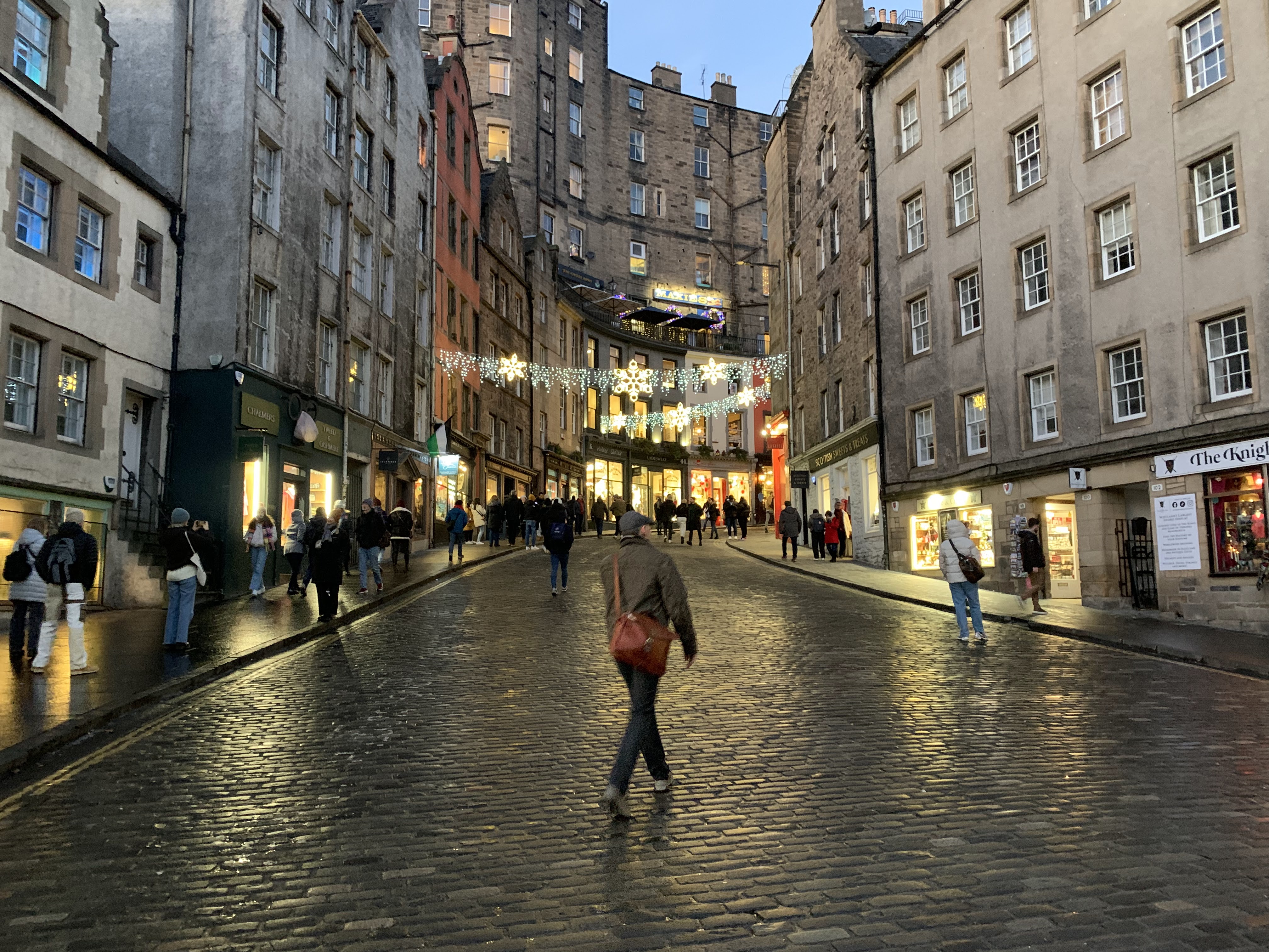
Shop and Christmas lights brighten a Edinburgh street
as darkness falls at around 4 p.m,


Back to a hazy Edinburgh overcast on December 2.

A hint of a rainbow on a changeable, gusty day along
the North Sea in North Berwick, Scotland, December 3.

Frosty day in Edinburgh, December 6.

Another rare treat of sunshine, but it was cold again
in Edinburgh, December 6

Nasty Flood In Pacific Northwest. And Perhaps Some Flooding In Vermont Coming Up?

National Weather Service expected rainfall map for
the next seven days shows several inches additional rain
in the flooded Pacific Northwest, with more than an
inch here in Vermont. An expected warm storm
Sunday would melt mountain snow, raising the
risk of some flooding in Vermont by then. 
 An atmospheric river - a ribbon of deep Pacific moisture - slammed into the Pacific Northwest over the past couple of days, causing a lot of flooding that led to at least one death, and a lot of damage. 

The death was of a man swept away in a creek near Portland, Oregon. In Washington State, more than eight inches of rain soaked some areas.  The Stillaguamish River north of Seattle got to a record high crest, CNN reported.

The Skagit and Snoqualmie rivers were at major flood stage.

The atmospheric river was accompanied by record warmth, meaning rain fell at high elevations above 9,000 feet. 

That added melting snow to the mix. At low elevations, Portland, Oregon reached 65 degrees, tying the record high for the entire month of December.

Seattle had a record high of 59 degrees and also a record for the wettest December 5 on record with 2.01 inches.

The rain is temporarily tapering off in the Pacific Northwest today, but another atmospheric river with more heavy rain and possible flooding is due over the weekend.

VERMONT STORM/FLOOD?

The Green Mountain State Sunday night and Monday could see a smaller, more minor but still concerning version of what happened in the Pacific Northwest.

It's drier and cold in Vermont this week as daytime highs stay in the 20s today through Thursday. There's' very little snow on the ground in the valleys, but he mountains have already piled up one to three feet of snow, well ahead of where we should be this time of year.

Near the summit of Mount Mansfield, 39 inches of snow was on the ground compared to a normal of about a foot and a half this time of year.

I mention this because a warm, wet storm seems likely Sunday and Monday, which could bring flooding and some strong winds. 

Some of the energy from the Pacific Northwest storminess will dive down into the southern Plains and Gulf Coast states. That will spin up a storm that will scoop up quite a bit of moisture from the Gulf of Mexico and bring it northward.

Since this storm is still likely to go by to our west, we'll get a shot of quite warm air on Sunday. At this point highs are forecast to reach the 50s by then.  A burst of pretty heavy rain seems like it wants to come through later Sunday and Sunday night. 

The combination of rain and mountain snow melt could easily be enough to put some Vermont rivers over flood stage. So far, this doesn't look nearly as bad as the flooding we had back in July. But still, we'll want to pay attention to this as water might be high enough to close some roads and create problems in low lying areas.

As always, the forecast will be fine-tuned between now and Sunday, so just keep the idea in your head that there might be some trouble with high water by the time Sunday night and Monday roll around. 

The storm might also produce areas of strong winds, so we'll keep an eye on that, too.