Friday, January 3, 2025

Will AI Make Climate Change Worse?

A coal-fired electricity generating plant in Pennsylvania'
AI is greatly increasing electrical demand, meaning
decommissioning fossil fuel run plants like this
are being postponed, harming the 
battle against climate change. 
 It turns out it takes TONS of electricity to generate AI. 

So much so that electricity demand in the United States, which had been on the stable side in recent years, is set to soar.  And that might screw up the battle against climate change. 

The amount of electricity needed for data centers will more than double between now and 2035. The increase is the equivalent to the amount of electricity the entire state of California used in 2022.

According to Environment America Research Policy Center: 

"Data centers currently make up 3 percent of America's energy demand but that is expected to rise to 8 percent by 2030.

The increase in data center electricity is primarily due to the significant data processing needs of Artificial Intelligence. As AI development accelerates, the need for data processing grows, and companies have to build more and larger data centers to meet those needs - and those data centers use a lot of electricity."

Moving toward EVs and other conversions that supposedly move away from fossil fuel is of course a good thing if you don't want to worsen climate change. 

But if demand for electricity skyrockets, the worry is some of that needed electrical generation won't be clean energy.  

Until now, electricity use hasn't grown much because of efforts to improve energy efficiency. As Environment America points out, the cleanest energy is the energy that never gets used in the first place.

They go on:

"When electricity demand is lower or at least stable and predictable, it is much easier to meet that demand with clean energy like wind and solar. A rapid and unexpected surge in electricity demand is the last thing we need, particularly when energy demand is already expected to grow due to electrification of buildings and transportation."

Environment America notes that utilities have extended the life span of coal plants and proposed new methane gas plants to meet the expected growth in demand from all these data centers. 

Each AI query a person does uses up a lot of juice. As NPR reported, one query to ChatGPT uses about as much electricity as what could power one light bulb for 20 minutes.  One ChatGPT query needs about ten times the amount of electricity as a Google search query.

So imagine what happens when millions of people are poking around Chat GPT or other sources of AI help. 

And as NPR tells us, a majority of that energy needed for AI still comes from the burning of fossil fuels like coal and gas.

The Washington Post tells us that soaring power consumption is delaying coal plant closures in Kansas, Nebraska, Wisconsin and South Carolina. 

Not only does this spiraling demand threaten to aggravate climate change, it also is making regulators worry that residential ratepayers will be stuck paying for the upgrades to the electrical grid

 Then there's this question. Like almost every Next Big Thing I've ever seen, there tends to be an over-enthusiasm bubble which might hit here. 

Will tech companies overbuild data centers only to see demand for AI fall short, maybe because of government regulation,  just too much capacity, or maybe the Next, Next Big Thing will come along after AI to wow the masses. 

If that happens, will we have built climate-damaging fossil fuel generating plants for no good reason?  And how much unnecessary emissions would that add to the world? 

I guess as the world gets more complicated, so does the battle against climate change. 

Vermont/New England In For A Long, Cold Blustery Week Or More, Mountain Snows Continue

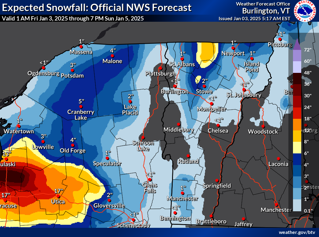
Not much snow this weekend for most of us, but notice the
eight inch expected totals in the northern Green Mountains
of Vermont. Plus the elephant in the room, the expected
three feet of snow downwind of Lake Ontario 
north of Syracuse, New York. 
If you liked the weather in Vermont yesterday, you're going to love the next week or more. Especially if you prefer it much colder than it is now. 

The cold air is coming in, but it's taking its time, despite the rushes of north winds we've been feeling. 

Winds as expected gusted to more than 40 mph Thursday but the temperatures didn't drop quite as quickly as anticipated. 

Burlington stayed above freezing until around 6 p.m. Thursday and most of us were still solidly in the 20s this morning. 

CHILL DEEPENS

 This January is shaping up to be much like 2022. That one also had  warm first couple of days but turned out to be another exception in our past decade or two of warm winter months.

The temperature will keep falling. Starting tomorrow and lasting at least a week, it's going to be persistently cold. Not extremely frigid, but the chill will have staying power. Highs will be in the teens to around 20, with lows in the single numbers to low teens through next Thursday and very likely beyond that. 

WPTZ Chief Meteorologist Tyler Jankowski noted on Facebook Thursday that the forecast for January 4 through 12 is the coldest since 2004. 

 Still, this won't be nearly as cold as some of the notorious Arctic blasts Vermont endured in the 1960s, 1970s and early 1980s. An example: On January 4, 1981, the low temperature in Burlington was minus 27 and the "high" temperature made it all the way up to (check notes) 13 below. 

Only a few places in Vermont were getting snow this 
morning, but traffic cam grab showed it was still
snowing and blowing along Route 58 in Lowell. 
The forecast low for January 4, 2025 is 13 above with a high of 20. So you see the difference. 

The weather maps for the next week look almost the same in our neck of the woods pretty much daily, which is a long time to go with no substantial change.

Every day for the foreseeable future will have that chill, along with lots of clouds and, almost a constant stiff northwest wind. The wind might relax a bit on Monday, but come roaring back afterwards

SNOW CHANCES

The strong, persistent northwest flow from Canada will suppress a pretty strong winter storm far to our south Sunday and Monday. That storm will eventually head way out to sea, then move north, intensify and stall near Labrador next week, keeping the cold winds over us going. 

Our only snow chances will come from moisture wrapping around that storm, and weak little disturbances riding that air flow from the northwest. I also think we might be getting a little moisture from Hudson Bay, which is usually frozen by now.   But there's still some open water up there, so that is probably adding a few extra snowflakes to the mix.

With the current weather pattern, Hudson Bay should finish freezing up soon, though. 

A strong lake effect snow band Thursday with some incredible staying power came off of Lake Ontario well south of Watertown, and held together pretty well as it clipped the southwest corner in Vermont. Its staying power extended all the way to and off the coastline of Rhode Island in the form of scattered snow showers. 

Traffic cam grab along high elevation Route 17 in Buels Gore
shows sun breaking through after fresh snow. Unsure
if that stuff that looks like steam in the background is
blowing snow or snow making at nearby ski areas.

Those lake effect snows are expected to dump up to three feet of snow mostly north of Syracuse, New York through the weekend. The snows from Lake Ontario will probably continue to reach parts of Vermont as light snow showers through the weekend, too. 

This is all good news for snow lovers in the mountains, but it means valleys will continue to see very little of it.

It will be interesting to get updates today on how much snow fell in the northern Green Mountains since yesterday

As of midday Thursday, 11.5 inches of snow had been reported at a 3,000 foot elevation in Underhill, and at another high elevation in Belvedere Center, with 10 inches in Braintree.

Even the southern Green Mountains got into the act with nine inches in Ludlow and eight inches in East Wallingford.

The snow in Vermont looks like it will keep piling up slowly in the mountains and mostly avoiding the valleys. 

The northern Greens can expect locally up to eight inches of additional snow between now and Sunday. More snow will surely fall up in the mountains much of next week.

In the valleys, nothing more than flurries and bursts of light snow. Eventually, even in the Champlain Valley, I imagine there we'd end up with a thin covering of snow, but nothing spectacular.  

Unlike the wild storminess of early January last year, the first half of January, 2025 is looking rather quiet and cold. 

Thursday, January 2, 2025

Helene-Ravaged North Carolina Endures New Flooding

Screen grab from WCNC shows a footbridge built
after Hurricane Helene being carried away downstream
by renewed flooding in western 
North Carolina last weekend. 
 The storm system that spread tornadoes across the South last weekend also caused renewed flooding and heartache in parts of North Carolina still reeling from the cataclysmic Hurricane Helene floods that struck in late September. 

The flooding wasn't anywhere remotely as bad as what happened in September, and wasn't even that extreme by North Carolina standards. 

But the post-Helene western North Carolina landscape is far from rebuilt.  A lot of ad hoc repairs that weren't meant to be permanent were washed away, creating a new, big setback. 

The storms dumped several inches of rain on some mountainous areas of North Carolina. 

As WCNC video showed, a temporary bridge that connected families to the outside world floated away amid high water in Avery County, northeast of Asheville. 

"We did do a lot of work early on to get footbridges build for folks so they at least had access to their homes, and those were all washed away," Robin Allis of the group Bridges for Avery told the television station. 

The group will need to raise more money to once again replace those bridges. It looks like they'll have to replace up to 100 temporary bridges wrecked by the weekend's heavy rain and high water.  I can only imagine the emotional toll the heavy rain and renewed flash flooding also had on people traumatized by Hurricane Helene. 

Officials in Avery County and elsewhere in western North Carolina said Helene has left rivers more unstable and debris-choked, so even relatively modest storms can cause renewed damage.  

In neighboring Tennessee, officials this weekend had to release water from behind the Walters Dam on the Pigeon River because of the heavy rain running off from the North Carolina mountains. The release caused a flood that swept away large pieces of equipment being used to repair a hydro station on the Tennessee/North Carolina border. 

A temporary ford giving access to residents across a river in Yancy County, North Carolina also washed away, but repairs to the makeshift path across the river was expected to finish by the New Year. 

This episode illustrates how important it is to rebuilt fully as quickly as possible after a big disaster, and to make that rebuilt environment as climate and disaster-resistant as possible.

Meanwhile, people still trying to recover from the Helene disaster are facing nighttime temperatures crashing down into the single numbers and teens and highs on some days remaining below 32 degrees. An ugly mix of rain, freezing rain, sleet and snow are in the forecast for the disaster zone Sunday and Monday.  

Winter Hype Vs Reality: Yes It Will Get Cold, But No Storm Of The Century

On December 30, the American computer models
depicted an intense storm over the Northeast on
January 11. This won't happen, but this type of 
thing doesn't stop the people hyping extremes
on social media from highlighting it for clicks
and revenue. Then the update.......
With the forces of Arctic air gearing up for an invasion into the United States, the social media hype on the weather corners of social media are gearing up for maximum clicks and hoped-for revenue.  

You know the drill

Worst Cold Wave Ever, Millions Will Die Of Hypothermia!!

Entire East Coast To Be Buried In Worst Blizzard Ever!

Huge Florida Snowstorm! Blizzard To Hit Cuba!!

OK, I'm exaggerating, the hype isn't quite that extreme, but you get the point.  

The social media weather weenie click addicts are taking advantage of an upcoming cold wave to really drum up the revenue efforts by telling you the End Of The World Is Nigh, and it's in the form of extreme winter weather. 

If you believe any of this crap, Me and Jackson the Weather Dog are here to calm you down.  The Storm Of The Century is not looming, so we can all take a chill pill.

The weather hype gang is cherry picking some of the more exciting computer model images. Every day, there are dozens and dozens of models and model runs forecasting what might happen a week or more down the road.

These long range models are useful in telling us overall trends. Will it be generally stormy or calm 10 days down the road? More than a week from now, will it be generally warm or generally cold? The long range models can help with those questions.  

What those models can't do is tell us specifically where a storm will be say, ten days from now, how intense it would be and what type of weather it would bring. 

The maps in this post illustrate how both the hype and reality work. 

This morning's American model for the same date as
above, January 11, shows benign weather over
New England. If this came true, we'd have a 
chilly northwest breeze and mountain snow showers.
It's too soon for either map on this page to fully,
accurately predict what will actually happen Jan. 11.

 For fun, I cherry picked one version of  the American model, issued December 30, which shows a super intense, probably destructive storm in the Northeast on January 11. 

If this came true, which it almost certainly won't, New England would face damaging winds, coastal flooding, inland flooding and deep, disruptive snow and ice inland. 

This is precisely the type of image the click bait people jump on. Stuff like this was all over social media. 

Then I took a look at one run of the latest American model, issued this morning, to see what they have planned for January 11. 

The answer? Not much. It shows a moderate, cold northwest wind over New England with some mountain snow showers and a nippy high pressure system approaching. 

Since January 11 is still more than a week away, we probably won't exactly have either of these scenarios, though the calmer version of the two is more likely.  This long range forecasts indicate it  will probably be cold, and a perhaps a bit unsettled on January 11, but it can't give us more details than that. 

What follows is the bottom line. 

Here's what we know:

 It's going to get cold here in Vermont, and in most of the eastern two-thirds of the nation sooner rather than later.  In most places, the cold won't be extreme for the middle of winter, but might intensify some once we get into the second week of the month. 

This won't be the tropical type winter month that we've seen too often in recent years. But it won't be the coldest ever. Not by a long shot. 

It's definitely going to snow in a lot of places, but for the most part it's too soon to say who will really get nailed with deep snow.  Places prone to lake affects snows near the Great Lakes are getting hammered, as you'd expect in this type of weather pattern.

It looks like some sort of storm will spread snow, ice and rain from Kansas to the Middle Atlantic States Sunday and Monday.  Exactly who gets the worst weather and how much they get is still TBA. It looks like it might end up being  a rather disruptive storm in those areas, but, hey, it's winter in the Grand Old U.S. of A.

Here's what we don't know: 

There will be other storms in the next couple weeks, and some places will get nasty amounts of snow, ice, schmutz, wind and cold.   But unlike some breathless things I've seen on YouTube and elsewhere, nobody's getting a repeat or worse of the Blizzard of 1993.

Computer models are also all over the place beyond a few days from now as to how intense the cold will get, where it will be at its worst and how long it will last.  True, the eastern  half of the nation will be nippy for sure..

But it remains to be seen whether this will be a run of the mill January wave or something worse. Winters have generally gotten milder, so even a moderately intense cold snap might feel pretty bad.

Here in Vermont, aside from persistent mountain snow showers, we seem safe from any big winter storms for awhile. The one I mentioned above for Sunday and Monday should pass by well to the south. 

Beyond about five days, it's virtually impossible to tell whether anything will come by to bring us substantial snow.  For what it's worth, the computer models aren't pretty much not showing anything dire for awhile, other than it'll be cold.  

Bottom line: The next time you see somebody tell you that a week from ten days from now, we will have some sort of dire, once in a lifetime weather event, ignore it, and move on. These people don't need the attention. 

The National Weather Service and your reputable local television meteorologists, or people like the Eye on the Sky folks in St. Johnsbury will have a much better handle on things. 

A Tale Of Two Vermonts This Morning: Snow Globe Or Snow-Free

A tale of two Vermonts today. Traffic cam this
morning along Interstate 89 in Colchester shows no
snow and clear sailing for motorists there......
 As expected, the Green Mountains of Vermont are being blasted by snow, while the valleys, not so much.  

The temperatures were slow to fall overnight, and were only getting below freezing in the lower elevations  as dawn broke.

The wind was cranking from the northwest, and that air had plenty of moisture in it. Trouble was, that moisture was skipping over the valleys and slamming into the mountains instead.

We're still looking at snow totals of over a foot in some spots along the central and northern Green Mountains.  Could be two feet or more at the end of it all up near Jay Peak.

As of this morning, Jay Peak has already reported at least 10 inches of new snow. 

This is probably one of the more extreme contrasts between Vermont snow winners and snow losers I've seen in quite awhile.

The heaviest snow is coming down this morning, but it will continue in the mountains through tonight, and probably into Friday and Saturday.  Those mountain accumulations won't be as rapid as they are this morning, but a couple to few inches a day still seem likely Friday and Saturday.

The bulk of the snow today is falling closer to the summits and on the upper east slopes of the Greens. But if you live in the Champlain Valley, in the lowlands along Route 7 in southwest Vermont, or lower to mid Connecticut River Valley expect just flurries at most today. 

The northwest wind is so strong that the snow isn't even really hitting the lower western slopes of the Green Mountains. You usually see some decent snows in situations like this along Interstate 89 in Richmond and Bolton, for instance, but traffic cams show it's not too bad there. You really don't start picking up the snow until you hit Waterbury. 

...but keep heading south along Interstate 89 and you start
hitting snow by the time you get to Waterbury. Pictured
here is traffic cam along Interstate 89 in Brookfield,
which looks like a snow globe. 

Things really change abruptly as you head east from the Champlain Valley into the Greens, so be ready for surprises. At my place on the eastern end of St. Albans, as of 8:30 a.m., it was just overcast, not snowing and barely a dusting on the ground. 

Barely ten miles to my east, there was already six inches of new snow on the ground in Bakersfield as of 7:30 a.m. and it was still snowing hard there. 

So don't be fooled by the easy driving in places like the Champlain Valley. If you have to cross over to eastern Vermont today, prepare for a white knuckle ride in snow and blowing snow. 

The blowing snow is definitely a problem. It is windy everywhere this morning, and that will only get worse as the day goes on.  Gusts were going past 40 mph in many spots this morning, and could reach 50 mph in some areas, especially along the eastern slopes of the Green Mountains, and near the open waters of Lake Champlain today. 

The wind will probably cause some scattered power outages, and I've already seen a smattering of them this morning across the state. 

If you're heading out into the elements to hit the ski resorts for some powder today, just note there are lift holds at most of the resorts because of the wind. You'll need to take your chances on which lifts are operating, and which are not. 

Now that it's below freezing, it's going to stay that way for quite awhile. The blasts of air from the northwest coming out of Canada will keep the next winter storm far, far to our south Sunday and Monday. Looks like places from Kansas to Maryland might get snow and/or ice out of that system, ut nothing for us in Vermont.

Except for every-present snow showers up in the mountains. 

Wednesday, January 1, 2025

We Did It AGAIN: 2024 Hottest Year On Record In Vermont

A thunderhead erupts in hot, humid weather in June
in St. Albans Bay. As measured in Burlington, 2024 was
easily the hottest year on record, breaking the
mark set just last year, in 2023.
Yes, Vermont had its hottest year on record in 2024. And it wasn't even close. 

On this date last year, I wrote a post about 2023 being the hottest year on record and could not believe we'd had four years in a row that were among Burlington's top 10 warmest.

Now in 2024, we've done it again, the fifth year in a row we scored in the top 10 list of warmest years. 

This year also knocked 1953 and 1898 out the Number 10 spot of warmest years in Burlington. That means all of the top 10 warmest years have happened since 1998, and nine of the top 10 have hit since 2010.  

That is simply bonkers for a period of record that goes back to the 1880s.  Climate change is really being felt in Vermont. 

Even more bonkers is the margin by which we broke 2023's mark for hottest year.  The average temperature in Burlington in 2024 was 50.9 degrees. That's 0.9 degrees - almost a full degree hotter than 2023.

That might not sound like that big a record breaker but a the hottest year on record by nearly a degree is insane if you consider we're averaging out 366 days (2024 was a leap year).

Since 2024 was the hottest year on record by such a large margin in Burlington, I'm going to go out on a limb and say you probably won't see a year as hot as the recently ended one for quite awhile, several years at least.

Then again, as I demonstrated a year ago, I can be proven wrong. We'll see. With climate change running on, though, it's inevitable we will have a year in Vermont even hotter than 2024. Unless you're quite elderly, you'll probably see a year or two or more toastier than the last one. 

It looks like St. Johnsbury also had its warmest year on record with a mean temperature of 49.1 degrees.   

That said, I have a feeling 2025 will break the streak and not become one of our top ten hottest years on record. Even with climate change, you need to have a cooler year eventually.  Today's mild weather notwithstanding, it looks like  January is going to be quite chilly, which would help drag down 2025's overall average temperature. 

After all, 2024 brought us no substantially cooler than normal months, and even many of the warmer years have at least one chilly month. Incredibly, eight months in 2024 in Burlington were among the top ten warmest. 

Burlington wasn't alone in seeing 2024 as the hottest. We'll soon have stats that show many cities in the United States just had their warmest year on record.  The United States  will probably see its hottest year on record as 2024. Plus, the world as a whole will see 2024 as its hottest year, though we won't have final numbers on that for a couple weeks .

Back here in Vermont, precipitation in 2024 was highly variable. Both in when it rained and snowed and where it rained. The summer was very wet, the autumn very dry. 

At Burlington, rainfall for the year was unremarkable. Total rainfall for the year there was 38.35 inches, which is just 0.82 inches above average

St. Johnsbury set a new record for rainiest year with 55.59 inches. That included an incredible 17.15 inches that fell just in the month of July.   Southern Vermont saw slightly below normal rainfall for the year. 

It was certainly an eventful year in Vermont, as we had several devastating floods, along with damaging wind storms, winter storms and oppressive heat. With climate change, extreme weather is becoming the norm in Vermont and many other places.

Expect plenty more weather weirdness in 2025. 

DECEMBER

December in Vermont broke the trend of warm months in 2024.  Most places saw temperatures near or just slightly below what is regarded as normal.  Remember, this is the "new normal," which is the average of temperatures between 1990 and 2020.

 Due to climate change those years were warmer than the 20th century average.  Had December, 2024's weather hit a half century ago, it would have been regarded as a little on the warm side. 

The biggest news of the month was when Burlington's temperature fell to minus 3 on December 22. That ended a record long 663 consecutive days above zero. 

A record or near record warm spell in the closing days of the month offset generally chillier than average conditions on several days either side of the Christmas holiday. 

Precipitation across Vermont was a little above average, which was good news after a remarkably dry autumn. Most of the precipitation fell on and around December 11, when 1.5 to as much as three inches of rain drenched the state.

Such a storm would have normally created some flooding, but it was so dry prior to the storm that there was little trouble with rainfall. 


New Year's Eve Day: Vermont's Transition Back To Winter Starts Tonight With Tons Of Mountain Snow

The National Weather Service is still expected a ton more
snow over the next couple of days in the Green
Mountains and Adirondacks, and western New
York snow belt areas. Lower elevations will
get little, consisted with earlier forecasts. 
 It was actually a strangely electric New Year's Eve up and down the East Coast as lots of thunderstorms blossomed with a dynamic storm that's setting the stage for huge pattern shift toward winter for the eastern half to two thirds of the United States.  

Some of the storms from Virginia to southern Connecticut were strong to severe with wind damage and hail reported in many areas, especially in Virginia and West Virginia.  Lightning strikes were reported as far north as southern Vermont.

Aside from intense lake effect snows in the usual spots near the Great Lakes and some very deep snow near mountain summits in northern New York, Vermont and New Hampshire, the initial cold spell won't be all that bad for early January. 

But it does look like the cold will intensify as we get into the second week of January. And possibly even get worse during the third week, but we don't know that for sure yet.  It looks like this won't be the type of mostly mild January many of us have gotten used to in the United States in recent years. 

VERMONT EFFECTS

Here in the Green Mountain State, the initial wave of rain and snow in some spots, passed through overnight and this morning.  Away from the lower valleys, quite a few places in Vermont managed to get a coating of wet snow, with a  few inches up high in the mountains to start things off. 

Some places look like winter again already 

I'm also noticing some patches of dense fog, especially in the northern Champlain Valley, so visibility will be a problem at times on the roads even without much rain or snow midday. 

A bit of a lull was taking shape by mid morning, as a second storm began to form along the New England coast. This will be the one that will blast us all with a lot of wind, and bury the Green Mountains and Adirondacks in a lot of snow.

Sorry, valley dwellers, it still looks like the lowest elevations should mostly miss out on the snow.

Later this afternoon and evening, rain should redevelop in the valleys as the New England coastal storm takes hold. It'll be snow in the mountains, and that snow will reach the lowest elevations as we head into this evening.

That's the best chance for the Champlain and lower Connecticut Valleys to get at least a white coating. Also, if you have to get somewhere, I'd do it now, or by mid afternoon at the latest to avoid most of the snow and ice that might accumulate on the roads. 

As the storm comes to an almost stall over southeastern Quebec, we're still looking at that classic upslope snowstorm scenario in the Green Mountains.  Northwest winds will be so strong that the heavier snow will hit the western slopes and summits as usual, but also extend a little bit onto the eastern slopes. 

A winter storm warning is still up for the central and northern Green Mountains and a good portion of far northern Vermont away from Lake Champlain.  While most places in the winter storm warning zone can expect a good 6 to 14 inches of snow, some of the central and northern Green Mountains could really get plastered.

From about Sugarbush north, that means one to two feet of new snow on the ski areas, with two feet most likely around Jay Peak.

As I said last night, though, the snow and blowing snow will make it tough to actually get to the ski areas Thursday. While driving conditions won't be the worst ever in the valleys, expect whiteouts in spots in the mountains. 

Plus the wind might be strong enough to prompt lift holds on some of the ski areas.

Those winds will gust to 45 mph for many of us, and 50 to even 55 mph on the eastern slopes of the Green Mountains. Combined with the snow, that could set off some power outages. 

Blustery, chilly weather should last for several days heading into early next week, with little new snow in the valleys, but periodic fluff bombs of light snow in the mountains almost daily.