|
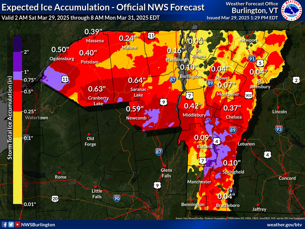
Aerial photo and schematic from the Jackson, Mississippi
National Weather Service office showing how two
tornadoes crossed paths within 41 minutes of
each other earlier this month. |
When there's a large tornado outbreak in the United States, you're almost guaranteed to hear odd stories about the behavior of at least some of those twisters.
So it was with the swarm of tornadoes that hit on March 14-15. So far, there have been at least 114 confirmed tornadoes with this outbreak, easily the biggest so far this year.
Of course, we have at least one weird story about this outbreak. As the Washington Post reports:
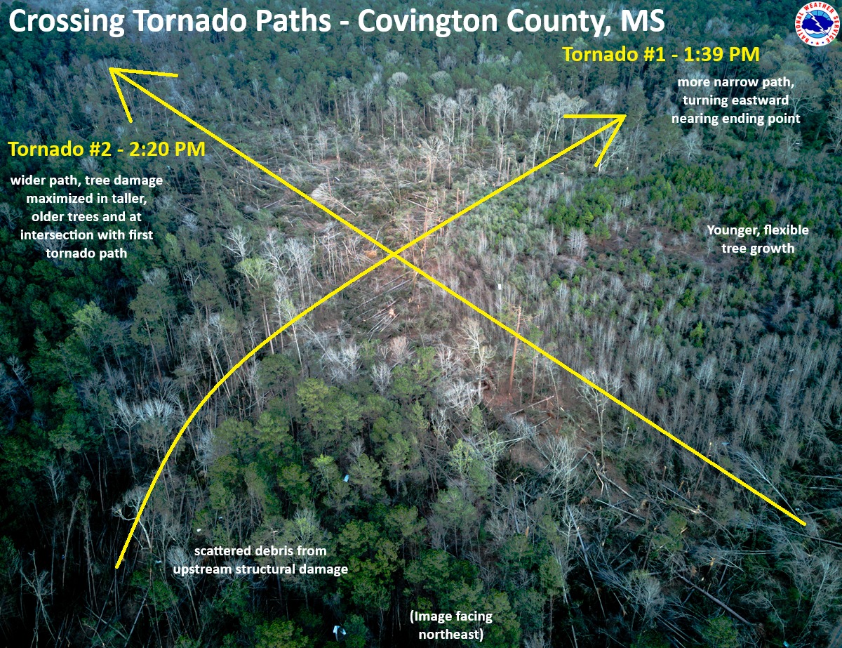
"In western Covington County, home too 18,059 people, a pair of tornadoes left a crosscrossing path of damage southwest of the town of Collins, the county seat, in an area just north of Spring Hill School Road.
"......the first one, a dying EF4 that had begun in northern Louisiana, hit the zone around 1:39 p.m. central time. By that point, it had covered more than 67 miles and been on the ground for 1 hour and 22 minutes.
Then, at 2:30 p.m, and EF2 tornado hit the same spot."
That had to be a pretty terrifying afternoon in Covington County.
The explanation, according to WaPo:
"Sometimes the most favorable conditions for tornado formation and maintenance exist in a small zone. When the storms pass through that sweet spot, they can spawn significant long-track tornadoes in rapid succession."
It is weird for two tornadoes to go in two different directions within the same hour, but it can happen.
My guess - and it really is just a guess - is the first one, ahead of a cold front, was associated with a supercell, which typical run southwest to northeast ahead of such a weather system.
The second one hit when the cold front was closer, and the inflow from the front might have helped the second twister to move southeast to northwest, toward the front.
Luckily, the two tornadoes intersected in a forested area. Though both caused damage, at least nobody's house got hit twice.
OTHER TORNADO ODDITIES
There have been other examples of large tornadoes crossing paths on the same day, or coming close to it. This is most common in very large or super outbreaks of tornadoes.
During the famous April 3, 1974 super outbreak of tornadoes, two intense tornadoes passed in close succession southeast of Flintville, a town in southern Tennessee.
On April 12, 2020, a deadly EF-4 passed just south of Bassfield, Mississippi, followed by an EF-3 that afternoon just north of town.
There are certain unlucky communities that have been repeated hit by horrible tornadoes. Tanner Crossroads, Alabama was hit by two EF-5 tornadoes on the same day in that big 1974 tornado outbreak.
Then in the next big tornado on April 27, 2011, another EF-5 tornado crashed through Tanner Crossroads. It's the only U.S. town known to have been hit by three EF-5 tornadoes.
EF5's are the worst possible tornado, with winds of over 200 mph. This type of tornado sweeps houses away completely and pulverizes them. Unless you are in a tornado shelter or a very protected basement, you would not survive such a twister.
There's also the unlucky city of Moore, Oklahoma, which has been hit by more than 20 tornadoes since 1961. Two of them were EF-5s and two others were EF-4s, the second strongest category of twister.
We have plenty of other examples of supremely unlucky towns in Tornado Alley
UNLUCKY PEOPLE
In Paragould, Arkansas, two tornadoes within less than a year of each other had crisscrossing paths that wrecked the same small group of houses in the Club View Estates neighborhood.
One of the homes, belonging to the Drope family, was damaged last May 26 in a tornado. They weren't able to move back in until a few months later. Then, on March 15, yet another tornado struck the same house, pretty much destroying it. .
This was actually the third time this family endured a tornado. A decade ago, they lived about ten miles up the road from where the remains of their current house is now. That former home when they lived there was also damaged by a tornado.
Just this past weekend, Rolling Fork, Mississippi was hit by a tornado. This one could have been worse. It caused some damage, but didn't hit the middle of town, and its winds were "only" about 100 mph. Bad, but not as bad as it could have been
But Rolling Fork residents are spooked by tornadoes, especially if they hit on March 23, like this one did. It was the second anniversary of and EF-4 that struck the town, killing 17 people and leveling most of the community.
By the way, the 2023 tornado might have been an EF-5, the worst kind, depending on how you measured it. I had a post on March 24 explaining some quirks in measuring these monster twisters.
Single tornadoes, or groups of tornadoes in one town can be particularly terrifying. In May, 2007, an EF-5 tornado destroyed Greensburg, Kansas. Then its path performed a loop, crossing its own path and repeating the damage just north of where it had just demolished Greensburg.
UNLUCKY YEARS
Then there are unlucky years, in which strong tornadoes hit big population centers repeatedly instead of mostly staying in rural areas. The year 1953 comes to mind. It was the only year known to have seen five F5 tornadoes until 1974, when seven such tornadoes hit in just the one Super Outbreak.
 |
Not the Midwest, but a Midwest-
style EF-4 tornado pictured here
struck Worcester, Massachusetts
of all places in 1953, killing 94
and injuring 1,300 |
The year 1953 featured massive tornadoes hitting larger cities. On May 11, 1953, a
huge twister hit downtown Waco, Texas, killing 114 people and injuring 597.
Barely a month later, on June 8, 1953, a F5 tornado hit the Flint, Michigan and surrounding towns killing 116 people and injuring 897.
The next day, the same weather system move into New England, spawning an F4 tornado in Worcester, Massachusetts and nearby towns, ending the lives of 94 people and injuring 1,300,
More recently, we had the year 2011, which brought the super outbreak of tornadoes on April 26-28 that spun off 360 tornadoes from Texas to New York. The outbreak focused the worst of its wrath on Mississippi and Alabama, which were raked by numerous intense tornadoes. This outbreak killed 321 people.
Then, less than a month later, an EF-5 tornado struck Joplin, Missouri on May 22. That massive storm killed 161 and destroyed much of the city.
In total, between those two tornado outbreaks and others, 553 people lost their lives in twister during 2011.
LATEST ODDITY
Tomorrow, a severe storm outbreak with large hail and even potential tornadoes is forecast in (check notes) an area of the Pacific Northwest encompassing Portland, Oregon and Seattle, Washington, among other cities.
Such an outbreak of severe weather is extremely rare in the part of the nation, but there you go.
The same storm system threatens to cause a new tornado outbreak in the Midwest, Gulf Coast and Southeast Sunday and Monday.