|
The intense June heat wave, which tied or broke all-time
highest temperatures for June in all six New England
states, is a sign of the times in the age of climate change. |
Welcome to the Age Of the Never Ending Summer
The relatively short, but intense and oddly humid heat wave that hit here in Vermont and much of the rest of the Northeast on June 22-25 is a symptom of longer, more brutal summers that have arrived due to climate change.
The high heat of summer now often comes earlier and more intensely than it used to.
That same heat now tends to overstay its welcome as autumn arrives. And the humidity that accompanies it is more brutal. It's only going to get worse. Sooner or later.
Per the Washington Post:
"The heat waves moving in recent days across Canada, the northeastern United States and northern Europe have one thing in common: They are occurring quite early in the season. The timing speaks to a broader trend, connected to human-caused climate change, in which summer-like weather is creeping earlier into June and lingering deeper into September - elongating the period of potentially extreme weather and amplifying heat risks."
Summer in the Northern Hemisphere is demonstratively longer than ever, or at least since accurate records began. The Washington Post has us looking at it this way:
"In a typical year between 1979 and 2000, the average Northern Hemisphere temperature would break the 21 degrees Celsius (69.8 degrees Fahrenheit) threshold - indicative of the hottest period - starting around July 10 and continuing for about five weeks, according to dad from the University of Maine's Climate Change Institute.
But last year, the hottest on record the Northern Hemisphere's average held above 21 Celsius from June 13 until September 5."
As of the week of June 16, the most recent data available, the Northern Hemisphere temperature was already at the cusp of 21 Celsius last week.
Temperatures of 90 degrees or more have become ridiculously common. Washington Post again:
 |
Fishing enthusiasts brave thick smoke on the shores of
Lake Champlain in June, 2023. Early and more intense
heat waves are creating early and more intense wildfires
in places like Canada, worsening health for people,
even those who are not experiencing hot weather. |
"The amount of land area in the Northern Hemisphere covered by high temperatures of this magnitude (90 degrees) was above average on 163 out of 171 days from January to mid-June."The widespread heat, even if it doesn't happen to be hitting here at the moment, extends wildfire seasons, affects crops, and can contribute to droughts if the heat lasts too long without rain.
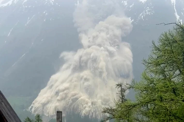
Local effects are becoming apparent. The Swiss Alps, where that catastrophic glacial collapse happened in late May, most of the other glaciers are losing mass several weeks ahead of normal.
We had those smoke attacks back in May and early June as the Canadian wildfire season got off to an early and brutal start due to record high spring temperatures.
Those more intense wildfires spread smoke far and wide, causing health problems for people hundreds and thousands of miles away, including those who aren't even experiencing heat waves.
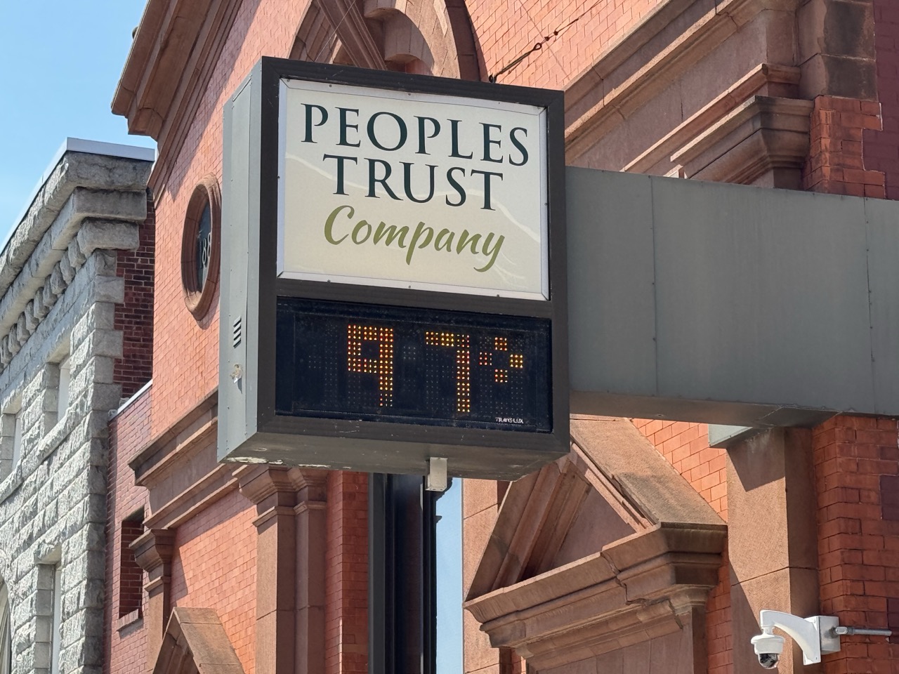
VERMONT'S HOTTER, LONGER SUMMERS
This is noticeable all over the world. Including here in Vermont. As I noted in a previous post last Tuesday, between 1900 and 1987, only five Junes in Burlington reached 95 degrees or higher. In less than half that many years, between 1987 and now, 14 Junes have reached at least 95 degrees.
These early heat waves keep getting stronger and stronger, too. Every New England tied or broke their statewide all time record high temperature for June. I did't realize this until three days after the heatwave, but North Springfield, Vermont reached 103 degrees, beating the state's previous June record of 101 degrees .
North Springfield's 103 degrees came very close to Vermont's all-time high of 105 degrees in Vernon, July 3, 1911. I still think within a few years, Vermont will exceed that 105 mark, and Burlington will break their current all-time record high temperature of 101 degrees.
The big heat all-time heat records tend to come in July and the first half of August, so 100 degree heat in a New England June is especially strange.
Not only are we seeing more extreme heat, we're seeing more days that make it to at least 90, echoing the trends elsewhere in the Northern Hemisphere. Aside from the strangely hot 1940s, which had some persistent hot weather patterns, most years in Burlington would have somewhere in the range of three to 7 days per summer with highs of 90 degrees or more. A few years had no 90 degree days at all.
That started to change in the 1990s, and that change accelerated in the past decade or two. All except one year since 2012 in Burlington has had at least eight days in the 90s. Each of the last five summers had 10 such days.
I guess if you're an optimists, we have more beach days than we once did. Always look on the bright side, I guess.
 |
People hit the beach in Burlington, Vermont on October 4,
2023 as temperature rose to 86 degrees, the hottest October
day on record. Summer weather is coming earlier in the
spring and later in the fall due to climate change. |
Summer weather is getting more and more out of season. New records for earliest and latest heat for the seasons have been falling fast in the Green Mountain State in recent years.
There's many examples from Burlington, Vermonts records, including:
A reading of 95 degrees on May 27, 2020 set a new record high for the entire month of May.
A temperature of 88 degrees o April 13, 2023 was the hottest for so early in the season.
The 96 degree reading on June 1, 2023 was the hottest for so early in the season.
Vermont's summer is extending into autumn, too.
On November 6, 2022, the temperature in Burlington reached 76 degrees, the hottest on record for the entire month of November. On October 6, 2023, the temperature in Burlington reached a summery 86, the hottest on record for that month. On October 31, 2024, the temperature reached 77 degrees in Burlington, the hottest for so late in the season.
You get the idea.
The chances of seeing summer weather when it's not summer are getting ever higher and higher.
HUMIDITY WORSENS, TOO.
In Vermont, the heat index reached 119 in Highgate, right near the Canadian border and 118 in Colchester and Cambridge. Though nobody keeps track of heat index climate data, these might well be the highest heat indexes on record in Vermont. I certainly can't remember anything like that.
The dew point, a measure of how much moisture is in the air, hovered near 80 degrees in parts of Vermont during the worst of the heat wave. Such high dew points are pretty much unheard of in the Green Mountain State.
New York set its record for highest heat index, too. Not in the concrete heat wave ovens of Midtown Manhattan or something like that. It was in Whitehall, just across the Vermont border from Fair Haven, where the heat index was 119 degrees.
A hotter atmosphere can hold more moisture than cooler air, so a climate change altered atmosphere is more humid than it otherwise might be.
Oceans are getting hotter, too. Warmer ocean water releases more moisture into the atmosphere, making it more humid. The source region for the air in our June heat wave was the Caribbean Sea, which is warmer than normal.
So the humidity was higher.
Climate change is Gonna Make You Sweat, but not in the fun, dance party way that C&C Music Factory gave us back in 1990. Our new summers are ever more miserable.
HEAT WAVE DEATHS
It's still unclear how many extra deaths might have occurred nationwide due to the June heat wave. I'm aware of one in Texas, one in Missouri and another in South Carolina. However, we usually don't have a good tally of heat related deaths until well after the hot spell ends.
There will be reports of higher death rates as trends are analyzed. I'm less confident that we'll ever know the extent of the June heat wave mortality because data under the Trump administration is far less reliable or complete than in past administrations.
The CDC under the Trump people isn't exactly forthcoming with information that might bolster the argument that climate change might be dangerous.
Things can go downhill fast in hot weather.
A mass casualty incident was declared on June 24 in Paterson, New Jersey during two outdoor graduation ceremonies held that day amid the record heat. At least 100 people fell ill, and at least 15 were taken to the hospital, NBC News reported.
Heat is the number one weather killer in the United States, and probably worldwide.
We don't have complete statistics for 2024 yet, but more Americans died from heat in 2023 than in any other year in over two decades of records, according to the American Medical Association journal JAMA.
A preliminary statistic I ran across for 2024 indicated 199 heat deaths last year. That is surely a major under-count. Still, that toll is higher than any other weather-related cause of death in 2024. Second highest was floods with 89 deaths and hurricanes, which claimed 78 lives.
At least 2,325 people died from heat in 2023, and that's probably also an undercount, researchers said. The combination of an aging population and worsening heat waves will probably keep the heat death toll rising.
THE REST OF SUMMER
We don't know whether the rest of the summer will be brutal or not, but trends have consistently suggested that most of the United States will have a hotter than average July and August. In many cases, it will also be more humid than average, if the forecasts pan out.
Sure, we had a couple cool, refreshing days immediately after the heat wave here in Vermont. Plus the Fourth of July forecast indicates some refreshingly bright and brisk weather. .
But overall, we can expect hotter times not only this summer, and summers to come.
The mere handful of hot days we used to get each summer are going to seem more and more quaint. Most summers going forward will be more of a blast furnace.
Summer weather will routinely start hitting when once the daffodils were barely blooming, and continue in bursts right into what was our traditional fall foliage season in early October.