Tuesday, December 31, 2024

New Years Eve Storm Update: Ski Areas To Get Their Snow Back, Valleys, Not So Much

Looked like spring in my St. Albans, Vermont back yard
this afternoon, but changes are coming very soon that
will put us solidly back into winter. 
This year will end up being the warmest on record, as measured in Burlington, so it was fitting that New Year's Eve was so warm. 

(I'll have much more on our warm 2024 in a post tomorrow).

We've got a new year coming in, so we have a new weather regime coming in.  Expect lots of cold weather for much of January, starting within a couple days. 

In terms of snow, it still looks like valleys will be missing out, while the Green Mountains will get very, very white. 

I figure an evening update is due since people will be traveling for the holiday. The forecast since this morning hasn't changed too much, though. 

For those out celebrating tonight, it looks pretty safe, at least in terms of weather. Rain will be spreading in overnight, but might  hold off until after midnight, especially in northern Vermont. The highest elevations might see some snow, but most of us will start off with rain. 

NEW YEARS DAY

If you remember what Thanksgiving was like, New Years Day will be pretty similar in Vermont. Snow will gradually work downhill from the highest elevations, gradually changing the rain to snowflakes until valley floors start seeing the snow, probably in the late afternoon.

Slippery, unpleasant driving conditions will gradually spread over more and more Vermont roads as the day wears on.  You might not want to get up early on New Year's Day, but the best travel weather will be in the morning, when most of us will still be raining. 

It won't amount to much in the valleys, as the snow should tend to taper off for a time in the evening. But overnight and on Thursday, some of us get a nice, big snowstorm.

WEDNESDAY NIGHT/THURSDAY

Our storm still looks like it'll slow down as it moves across Maine and into Quebec Wednesday night and Thursday. It's setting us up for a classic upslope snowstorm in the Adirondacks and especially the central and northern Green Mountains. 

In the Champlain Valley, especially close to the lake, it won't snow much at all. Flurries, basically. Same is true for the Connecticut River Valley, especially south of about Wells River.

The Green Mountains will get plastered, with generally more snow the further you head north. Almost the entire ridge line of the Green Mountains should get at least eight inches of snow, with a foot or more in  many northern Vermont mountains. The Jay Cloud will work overtime, and I'm still expecting up to two feet of new snow up there by Friday. 

It's also going to be really windy everywhere later Wednesday night and Thursday.  Many of us will see gusts to at least 40 mph. Some areas along the eastern slopes of the Green Mountains could see gusts to 50 mph. 

That could lead to isolated power outages. The blowing snow in the heavy snow zones will be absolutely brutal.  Expect some whiteout conditions along roads in the Green Mountains. 

You might be tempted to go up to the ski resorts Thursday for a powder day. Just be warned, it probably will be tough to get there, even if the valley highways aren't bad at all. I also suspect some ski areas might have some wind holds on the lifts. I also think back country skiers might worry about an avalanche risk on steep slopes, too. 

Vermont's Biggest Weather Events, 2024: There Were A Lot Of Them

 Once again, 2024 brought Vermont an eventful, often destructive and painful weather year.    
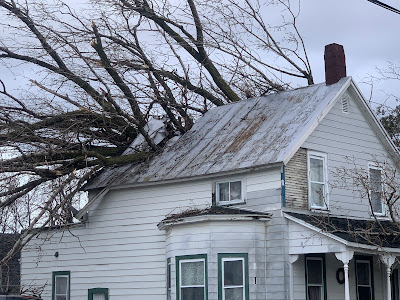
High winds on January 10 toppled a large tree, which
crashed through this St. Albans, Vermont home. 
It will be among the warmest years on record again, much like several previous recent years.  More on that in a post coming along right around New Year's Day.  

The weather extremes of 2024 were all over the place, from wind to floods to drought to heat to cold. Though not that much cold.  The weather often turned destructive, sometimes tragic. 

Weather in Vermont has never been boring. But nowadays, probably because we're in the age of climate change, things are getting even further out of whack. 

Lots of extremes happened in 2024, so let's get into it:  

TWIN WINDS, JANUARY 10 AND 13

Two intense wind storms swept the Northeast including Vermont in mid-January. 

The first of the two hit on January 10. 

Winds gusted to 69 mph at the National Weather Service office in South Burlington, their fourth highest wind gust on record.  Power was cut to 29,000 homes and businesses.

St. Albans was particularly hard hit, with at least three home virtually destroyed by falling trees, with several other houses suffering some damage. 

Along the New Hampshire and Maine coasts, the storm and wind generated a huge and in some case record storm surges which caused massive damage. A new storm a couple day later made everything there even worse 

That second storm hit on January 13, especially along the western slopes of the Green Mountains, where winds topped 80 mph in some spots. The wind blew the roof off a house in Richmond, and fallen trees again blocked numerous roads. Power outages in Vermont again reached a peak of about 29,000 customers. 

FEBRUARY

Another warm winter month. Record warmth on February 9-10  and 27-28 contributed to an average February temperature of 30.2, the third warmest on record. The high temperature of 65 degrees on February 28 would have been the hottest on record in Burlington if not for recent, even bigger February hot spells in 2017 and 2018.

BIG APRIL 3-5 SNOWSTORM
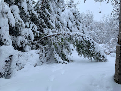
Damaged trees after 16 inches of wet, heavy snow
fell on St. Albans, Vermont in early April. 
One of the biggest April snowstorms on record blanketed the entire state. Biggest snow totals included 24 inches in Moretown in Killington, 21 inches in Underhill and Eden, and 20 inches at Brookfield and Stowe.

Burlington had 10 inches of snow on April 4, its third snowiest April day on record.

The snow was wet and heavy, causing widespread tree damage and power outages. 

VERMONT ECLIPSE GOOD  LUCK

Northern Vermont was in the direct path of the Big Solar Eclipse Of 2024.  It was widely expected that few of  us would see it, as on average we'd have an 80 percent of overcast skies that time of year. 

Instead, the Green Mountain State was blessed with fair skies. There was a broken layer of very thin, high clouds, but that augmented the experience by adding some odd sunset style colors to the sky during the big event. 

We had a second episode of celestial good luck when one of the biggest, brightest most extensive northern lights display graced much of the northern hemisphere as far south as Cuba on the night of May 10.

Though skies had been forecast to be mostly cloudy, most of the night ended up mostly clear in Vermont, allowing for great viewing of the rare event. 

JUNE 18-20 HEAT, STORMS

 Brief but intense heat wave, accompanied by severe thunderstorms in some areas. North Springfield had daily highs during the period of 98, 99 and 101. Union Village Dam in southeastern Vermont had 100 degree highs on two consecutive days. 

Flash flooding in South Burlington, Vermont following
intense storms on June 23. Some of the storms 
prompted tornado warnings, but none were known
to have touched down in Vermont. 

Burlington reached 96 degrees on June 19.  The low temperature that day in Burlington was 80 degrees, tying the record for the warmest overnight low of any day in more than 120 years of records.  

The heat was accompanied by strong storms in some parts of Vermont. After reaching 93 degrees on June 20, Burlington had about an inch of rain within 15 minutes with a storm wind gust of 48 mph.

 Trees came down in Burlington and Stowe, as a precursor to even bigger storms a few days later.

JUNE 23 TORNADO ALERTS AND FLASH FLOOD

A stalled warm front just to the north and an incoming cold front, combined with very humid air set the stage for a severe weather outbreak on June 23.  Forecasters had called for a risk of tornadoes, and in fact a handful of tornado warnings were issued in Vermont as radar showed notable rotation.

Wall clouds and possible funnels were reported, especially near Monkton, but no tornadoes are known to have touched down. There was some tree and power line damage from winds, but that damage appears to have been caused by straight-line winds. 

However, the supercell thunderstorms contained intense downpours, and the two strongest followed roughly the same path across north-central Vermont. The result was flash flooding, the worst of which hit around Stowe and areas around the Worcester Range. Washington County was subsequent declared a federal disaster area due to the flash flood damage.

This flash flood was just a foretaste of what was to come. 

JULY 10 FLOOD DISASTER

Another stalled warm front, and the remnants of Hurricane Beryl caused a new extreme flash flood disaster on the exact anniversary of a similar calamity that hit exactly a year earlier. 

A tractor fell into the ravine created by this road
washout near Hinesburg,  Vermont on July 10.
Unlike the 2023 flash flood, which hit most of Vermont, the July 10, 2024 was mostly focused on northern and central Vermont.  Rainfall totals were as high as nearly seven inches in Hinesburg.

Two deaths were reported in the storm, one in Lyndonville and the other the Peacham. 

This disaster re-flooded homes and businesses damaged in the flood the previous year. Hundreds of roads and bridges suffered significant damage, and as of the end of this year, not all the repairs had been completed yet.  

Some of the more dramatic incidents during this disaster included an apartment building that was mostly swept away in Plainfield. The building's occupants evacuated shortly before the the structure collapsed. 

To nobody's surprise, large swaths of Vermont were declared disaster areas.

The disaster was preceded and followed by oppressive hot, humid weather, which slowed post-disaster cleanup. Lebanon, New Hampshire had a record 12 consecutive days in the 90s from July 6-7. It was Burlington's third hottest July on record. 

EXTRME NEK FLASH FLOOD JULY 30.

Early morning thunderstorms on July 30 dumped an incredible amount of rain in just a few hours in large parts of the Northeast Kingdom. St. Johnsbury received eight inches of rain in just four hours, which is the amount of rain that normally falls there in the summer over the course of two months. 

The resulting flash flood washed away houses in Lyndonville and other towns, but miraculously no deaths were reported. 

But there were close misses. One woman was rescued by neighbors after her house fell into a raging river with her inside it. Two elderly women, one age 98, and their dog, were pulled through their bedroom window by neighbors after their home floated onto a road and thankfully got stuck there instead of washing away and completely disintegrating. 

The storm was highly localized. The eastern end of the town of Danville had 7.4 inches of rain. Another location in the western part of the same town just six miles away received just under an inch of rain. 

A weak upper level low pressure system drifted northwestward into New England and stalled for a time over the Northeast Kingdom, causing the extreme downpours. 

DEBBY REMNANTS CAUSE WIND DAMAGE 
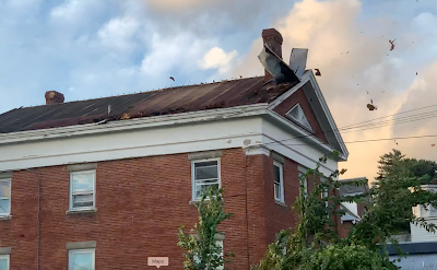
High winds associated with former Hurricane Debby blew
the roof off this building in St. Albans Bay, Vermont. 
The remnants of Hurricane Debby swept over Vermont on August 9, causing a surprisingly strong wind storm that evening. Burlington gusted to 62 mph.  

In Alburgh, a large falling tree crushed a house, trapping a resident inside who was later rescued. The roof blew off a house in St. Albans Bay. 

Numerous roads across Vermont, especially the Champlain Valley, were blocked by fallen trees and power lines. At one point, 49,000 Vermont homes and businesses were without power. 

LATE OCTOBER/EARLY NOVEMBER HEAT

Summer seemingly did not want to quit in the last ten days of October and the opening week of November..

Burlington tied or broke four record highs from October 21 to 31, including a reading of 77 degrees on Halloween. That was the warmest for so late in the season.  Plattsburgh soared to an unbelievable 83 degrees on October 31. Woodstock reached 80 degrees.

The late autumn heat had a final resurgence on November 6 as temperatures climbed to 75 at Union Village Dam, Woodstock and Bennington

FLASH AUTUMN DROUGHT, FIRES

On October 8, no areas of Vermont were in drought. Just eight weeks later, 70 percent of the Green Mountain State was deemed to be enduring drought conditions. 

The drought created a slew of unusual autumn forest and brush fires across the Northeast, including here in Vermont. The Green Mountain State had its worst fire year since at least 2016, thanks to autumn brush fires. One of the fires burned through 70 acres near Barnard. 

HOT YEAR ENDS ON HOT NOTE 

2024 will be the world's hottest year, and the hottest year on record here in Vermont. The year came to a fitting end with a record heat wave on December 29-30.  The temperature reached 61 in Burlington on December 29 and 60 on December 30, both record highs for the date. 


Record Warmth To Vermont Winter Storm As We Head Into The New Year

Big contrasts in snowfall expected with upcoming storm
Less than an inch in lowest valleys far west and far east
in Vermont, while Jay Peak could get two feet. 
It's toasty out there again this morning, as we get one last day of our end of 2024 heat wave. 

We won't have any record highs again today, but we never did get below freezing last night and many of us will be well into the 40s this afternoon. 

Burlington was the big heat winner with this warm spell. We already told you about the record high of 61 on Sunday, set at around 11 that night.

The city also managed to reach 60 degrees Monday, breaking the record high of 58 for the date set in 2022. 

Other high temperatures around the region Monday included 58 in Bennington and Highgate, 57 across the pond in Plattsburgh, 53 in Springfield, and 51 in Montpelier 

The thaw gave Montpelier a bit of a scare yesterday.  An ice jam formed in town, making the Winooski River rise rapidly in Montpelier. The city is still spooked by devastating floods in recent decades, including a 1992 ice jam flood.

In this case, city officials went to work, breaking up the jam with a backhoe and spraying warm, treated effluent onto the ice jam to make it melt. It worked, the jam quickly broke up, and water receded without every quite making it to flood stage. 

NEW STORM

That oft-mentioned New Years Day storm coming in is going to cause some pretty wildly different conditions in Vermont. We're going to have some big time snow winners and losers here. 

By the end of the week, some of the lower valleys of far western and far eastern Vermont will see barely an inch of new snow, if that.  Meanwhile, the northern and central Green Mountains are in for at least a foot of snow.  I wouldn't be the least bit surprised if the Jay Peak cloud over-performs and dumps two feet of snow on that ski area near the Canadian border.

The storm causing all this is pretty dynamic, judging from the very low, but not zero chance of tornadoes today oddly north in parts of Ohio, West Virginia, Maryland and Delaware.

As I mentioned yesterday, the storm is taking the perfect path to dump at least several inches of snow all over Vermont. Too bad there's not enough cold air for snow. The valleys should see mostly rain overnight and New Year's Day, at least for the first half of the storm. 

There is the slightest chance of a New Year's miracle which would chill the air enough to produce snow even in the valleys, but I'm not holding my breath on that one. 

Once the storm gets to eastern New England, it will really start to crank up, then move northward into eastern Quebec and pretty much stall for a couple days. 

That will set up a strong, cold, wet northwest air flow that will last from Wednesday night to at least Friday. It's a classic setup to dump tons and TONS of snow on the central and northern Green Mountains while people in the Champlain and Connecticut River valleys wonder what all the fuss is about. 

The National Weather Service office in South Burlington has posted a winter storm watch for Franklin, Orleans, Lamoille and Washington counties in Vermont, and also the spine of the Green Mountains all the way to south of Killington. 

Winter storm watches are also up for the Adirondacks and in western New York, where the lake effect blasts are set to start again. 

The snow contrasts here in Vermont will be striking.  In Franklin County alone, I'll be surprised if St. Albans Bay gets as much as 1.5 inches. At my place on a high spot on the eastern part of St. Albans, I'm probably in for four or five inches. 

Head up to eastern Franklin County toward Bakersfield, Richford and Montgomery, we're probably talking more than a foot. Maybe even a foot and a half in a couple high spots.

We're also going to see some screaming northwest winds with this, with gusts over 40 mph, so we'll find plenty of blowing and drifting snow, especially where there's a lot of it. 

Plan on travel trouble in high elevations Wednesday, in most of the state Wednesday night, and in the northern and central Green Mountains Thursday and probably Friday.  

Once temperatures fall below freezing later Wednesday, they'll stay there for a long, long time.  Quite possibly until at least mid-month, so any snow that does fall will stick around for awhile. 

Monday, December 30, 2024

Federal Employees Hunkering Down In The Face Of Trump, Musk Threats

Federal workers at NOAA are among those at 
government agencies who are scrubbing their social
media accounts to appease Donald Trump. 
If someone says something "outrageous" like
climate change is real, these workers
fear retribution from the thin-skinned
soon to be president. 
 Donald Trump hasn't even officially taken office yet, and already climate science is already starting to take a hit.  

Trump hates anyone he thinks is disloyal to him.  Disloyalty in his mind includes any disagreement with his worldview. 

Since Trump still thinks climate change is a hoax and the overwhelming majority of scientists think the opposite, those professionals are now vulnerable. Especially those who work for the federal government. 

The includes anyone from National Weather Service meteorologist, to climatologists to the many who work in government agencies that deal with the environment.  The environment, after all, is affected by climate change.  

These scientists are hunkering down. 

According to the Washington Post:

"One meteorologist at the National Weather Service recently deleted all references on his social media accounts to the threats climate change poses for extreme weather, along with any mention of union support, 'to make everything about me much more apolitical,' he said. Trump has long rejected climate science and cast doubt on the dangers of climate change." 

The National Weather Service is part of the National Oceanic and Atmospheric Administration (NOAA), which could end up being dismantled, if the folks who came up with Project 2025 or Elon Musk's dreams come true

"I generally take people at their word, and these people have said some pretty awful things about federal workers," the meteorologist told the Washington Post. He remained anonymous because he doesn't want a target on  his back from Trump or his minions.

During Trump' first term, some federal climate change researchers left those jobs and were not replaced, but at least none of them were fired over Trump's anti-climate ideology.

This time, nobody is so sure. 

Some divisions are changing the names of research projects so they don't get flagged by Trump's minions as pro-environment type activities, according to WaPo. Also, some agencies are removing the names of career scientists from projects so they don't garner Trump's negative attention. 

I don't know whether all this prep is fear, or resistance, or self-preservation or all of the above. But it's a shame people have to hide their professions from the soon to be leader in what is supposedly a free country. 

Autocracy has arrived. And it's only going to get worse. 


A Surprise Overnight Heat Wave In Vermont, Late Night Record Highs

It's becoming  weird late December tradition around my
St. Albans, Vermont house. Record warmth has 
caused these daffodil shoots to sprout out of season
Same thing happened in recent Decembers. 
 We knew it would get warm here in Vermont overnight and this morning, but what happened is kind of ridiculous. 

Rather than reach the low 50s by this morning, Burlington, Vermont's temperature rocketed upward last evening, peaking at 61 degrees at around 11 p.m. That was good enough for a record high for the date, the old one being 58 degrees in 1984.

As you well know, 11 p.m. is an odd time of day to see a record high.  

Burlington was probably the warmest place around, because winds from the southeast had some compressional warming as gusts flowed down the western slopes of the Green Mountains. Still, it did manage to reach 58 degrees in Bennington, 55 in Rutland, and 57 in Plattsburgh, New York.

Place east of the Green Mountains have mostly so far missed out on the warmth.  The mildest it got in Springfield so far is 48 degrees. St. Johnsbury has thus far only managed to get as mild as 41 degrees. 

As of early this morning, it look like Burlington at least tied the record high for today's date of 58 degrees.  We'll see how that sugars out.

We've been re-writing the record books for late December in recent years. In 2015, it was 68 degrees in Burlington on Christmas Eve, the hottest December temperature on record. Our hottest Christmas was in 2020, with a temperature of 65 degrees. Just two years ago, in 2022, the record high that was probably tied today was set. 

COOLING TREND

I hope you got outside to enjoy Vermont's tropical warmth early today as you won't see temperatures like this again for a long time. 

Temperatures will gradually cool today behind a cold front that was on our doorstep as of 8 a.m.  It'll remain mild all day, but temperatures will fall through the 50s and 40s and into the 30s by sunset late this afternoon.

We could even see a snow shower or two this evening. It is winter, after all, though it didn't feel like it the morning.

New Year's Eve looks quiet and mild for the season, with highs in the upper 30s to mid 40s. Pretty warm, still for this time of year, and made all the better by some expected glimpses of sun, especially in the first part of the day. 

We're still looking at a new storm for New Year's Eve and Day.  It'll be a frustrating storm for snow lovers, because its path would normally be perfect for laying down a nice Vermont snowpack to replace what we lost in the heat wave we just had. This system will basically follow a path from New York City to Boston to Portland, Maine on New Year's Day. 

But alas, there won't be enough cold air around, so deeper valleys still look like they'll have a cold rain for most of the storm.  Higher elevations have a better chance of seeing some snow. 

Once the storm gets past us, it'll help introduce a long period - probably lasting at least two weeks - of cold air.  That storm will probably stall for a few days in eastern Canada, dumping more snow on Vermont mountains, but leaving valleys with little new snow. 

So expect a thin snow cover in the valleys for at least the first few days of the upcoming long January cold spell.  High elevations should get a decent share of their snowpack back. 

 Subsequent storms might come along to allow the valleys to join the January snow party, but it's too soon to tell how that will play out. 

Sunday, December 29, 2024

As Expected, Tornadoes, Storms Spread Havoc Across The South, Caps An Extraordinary U.S, Tornado Year

Screen grab from Storm Chasing Channel video of
a tornado shredding trees Saturday in Mississippi
 At least two people died and damage is widespread from Texas to the Carolinas as the widely forecast Saturday severe weather outbreak unfortunately materialized.  

As of this morning there were at least 41 reports of tornadoes, mostly across eastern Texas, Louisiana, Mississippi and Alabama.

One person died in a tornado south of Houston, and a likely tornado claimed another life in Mississippi. 

Video showed a large tornado near Bude, Mississippi that unroofed several homes. Another video by the Storm Chasing Channel's Scott Peake shows the same tornado crossing a highway and shredding trees around a parked pickup truck. 

A likely tornado hit downtown Athens, Alabama overnight, tearing the roof off a court house and spreading debris through the streets. 

The storms moved into the Carolinas Sunday morning.

Flash flooding hit parts of western North Carolina early today in an area still reeling from the extreme floods from Hurricane Helene in September. This morning's flooding wasn't remotely as bad as that, but this region doesn't need more bad weather news. 

Up to four inches of rain fell in some of the steep terrain in those North Carolina mountains. 

During the busiest travel time of the year, storms were mostly responsible for 15,000 canceled or delayed flights over the weekend, according to FlightAware.  Most of the airports where the delays and cancellation originated were in the path of the southern storms. 

After the severe storms end later today, forecasters say there's little chance of additional widespread severe storms and tornadoes for at least a week and probably more, as colder air floods into much of the United States. 

A cold air funnel begins to form over St. Albans, Vermont
in a non-severe thunderstorm on June 9.  This was a type of
spin that is not associated with tornadic thunderstorms
and these tend not to be dangerous.

This year has been quite a year for tornadoes in the U.S. Through November, no fewer than 1,762 tornadoes were confirmed, which is the highest number since the epic twister year of 2004.  That year, 1,813 tornadoes were reported in the U.S. 

The number of death in tornadoes this year was 52, which is bad, but pretty low considering how many tornadoes spun up, and how many of them were pretty strong. 

For comparison, there were 83 U.S. tornado deaths in 2023, with 1,321 twisters being reported that year. 

Of the 24 weather and climate disasters in the U.S. this year that cost over $1 billion in damage, six were tornado outbreaks and a handful of others included some tornadoes in the mix.

NBC News reports one odd note about 2024 tornadoes, and that's the propensity for strong tornadoes with landfalling hurricanes.

Most hurricanes that make landfall in the U.S. do spin off some twisters, but most of those are relatively weak with top winds of up to 110 mph. Fewer than 1 percent of tornadoes associated with hurricanes have an EF-3 rating, which means destructive winds of 136 mph or more. 

But four of the five hurricanes that made landfall in the U.S. this year produced EF-3 tornadoes. Hurricane Milton, which hit Florida in October, sent a swarm of dozens of tornadoes through the state. 

This year also continued a trend toward more eastern tornadoes. True, the traditional "tornado alley" in states like Texas, Oklahoma and Nebraska were hit hard, but there were areas of pretty weird activity in the Northeast. 

New York had 32 tornadoes in 2024, breaking the single-year record for twisters of 25, set in 1992.

Right here in Vermont, there were no confirmed tornadoes in 2024, but some close misses. On June 23, tornado warnings were issued in parts of central Vermont due to rotating thunderstorms and reported wall clouds, but no confirmed twisters touched down in the Green Mountain State.

There was a tornado that day in Dublin, New Hampshire, about ten miles east of the Vermont border. 

On July 10, a tornado dissipated in New York state not far from the Vermont border, and a funnel cloud was spotted over Bridport. 

A tornado struck Lyme, New Hampshire on July 16, and its path started just a couple miles east of the Vermont border.  

Dodging The Vermont Raindrops In Run Up To The New Year

The triplets, as I call the three big trees in my St. Albans,
Vermont back yard, caught a glimpse of blue sky this
morning before expected rain this afternoon. The lawn
was covered in snow yesterday, today not so much
after thawing began yesterday and continued overnight. 
 We can certainly thank our lucky stars that the storms the originated with tornadoes in the South yesterday are weakening as they head north toward New England.  

Which means we only have to deal with rain, and the temporary disappearance of our snow cover in Vermont, though the upper elevations should be able to hang on to most of it.

We started dodging light rain showers Saturday as the thaw began, and we have occasional bouts of rain to deal with through New Year's Day.  

Yes, this will interfere with your plans to play in the snow, but winter will be back with the New Year. I promise. 

Temperatures were still kind of all over the place early this morning. Burlington, where a steady south wind kept blowing all night, was a balmy 41 degrees this morning. My place in St. Albans was also 41 degrees as south winds stirred. 

Meanwhile, across the pond in Plattsburgh, where winds are calm and the skies partly cleared for a time, it was down to 27 degrees. Most of Vermont was in the 30s, with below freezing temperatures up in the Northeast Kingdom.

There was, once again, patchy dense fog around Vermont and surrounding areas this morning, so be careful on the road for awhile. There might be some spots with limited visibility. 

An approaching warm front will flush out the last of the chilly air that was still lingering in spots this morning.  That means if you see a glimpse of blue sky this morning, enjoy it. It'll be gone before you know it. 

The warm front will bring a quick burst of rain from south to north across Vermont this afternoon. Nothing heavy, and I'm not too worried about freezing rain.  The rain could freeze on impact on a few cold surfaces in the Northeast Kingdom, but it won't be anything widespread. 

TONIGHT/MONDAY

Overnight will have a bit of a balmy but stormy feel.  The burst of rain from this afternoon will be gone by evening, but will be replaced by more rain later on and through Monday morning. It'll get windy in spots, too, with some areas of the northern Champlain Valley and some of the northern and western slopes of the Green Mountains and Adirondacks gusting to 40 mph or a bit more.

Luckily, this isn't all that extreme. Just a noisy, warm late December night. There won't be enough rain or snowmelt to cause flooding, and the wind won't be nearly strong enough to cause any widespread power outages. 

We're good.

The afternoon Monday will feature warm weather, though temperatures will fall slowly out of the balmy low 50s into the 40s before sunset, probably.  There might be a couple light showers around, but no biggy. 

NEW YEAR'S EVE

It seems like in so many years in my lifetime, we have an ill-timed subzero cold blast to freeze us up for our New Years Eve festivities.

This won't be one of those years.  

The day looks quiet and warm, with highs in the upper 30s to mid 40s.  As the clock approaches midnight, rain will be approaching from the next not huge but still noticeable storm. 

I'm unsure whether the rain will get here by the time the ball drops or whatever at midnight, but it will be close.  During the runup to midnight, temperatures for most of us will be in the 30s, which is pretty toasty for this time of year and that time of night. 

If you indulge too much New Year's Eve, New Year's Day will bring us the perfect weather so we can sleep in. It'll be a dark, rather rainy, chilly day.   Snow will start to mix in up in the mountains, and gradually head toward the valleys as we get later and later in the day.  

WINTER'S RETURN

Starting late on January 1, it should be cold enough for snow pretty much everywhere in Vermont. It doesn't look like any kind of big dump of snow is in the offing. But the increasingly cold and blustery weather pattern does favor at least several inches of snow up in the mountains to grace the second half of the week. 

Saturday, December 28, 2024

Dangerous Tornado Outbreak Lurks In Southern United States Today

There's a risk of tornadoes, some strong and long lasting
in the South today and tonight. The greatest risk is in
the orange and red zones of this map. 
 A year-end tornado outbreak seems like it's about to blossom in the South today, throwing one more potential disaster as a United States to close a year that brought us far too many destructive storms.  

NOAA's Storm Prediction Center says most of the Gulf Coast states from eastern Texas to Georgia, and as far north as Tennessee are under the gun today.  The most threatened area is in central Louisiana and southern Mississippi, 

The bad weather was getting off to an ominously early start. At least five tornado reports came in from right along the Gulf Coast in Alabama and Mississippi yesterday.

Already as of mid-morning, a tornado watch has been issued for most of Louisiana, along with far eastern Texas and southwestern Mississippi.  A smattering of tornado warnings have already been issued in Louisiana, and severe thunderstorm watch is added to the mix in northeast Texas and southwest Arkansas.

It's only going to get worse as the day goes on, apparently. 

There is enough spin in the atmosphere to create the risk of a few isolated twisters this morning where there's that tornado watch. That there's already a small risk before the main show arrives feels ominous to me, like all hell might break loose this afternoon.

We have no guarantee that will happen of course. But forecasters do say that this afternoon, that same area will see dramatically worse atmospheric condition.  

THE SETUP

A strengthening storm will pass north and west of the main tornado risk area later today and tonight, dragging a cold front towards the region.  The cold front should contain lines of severe thunderstorms with some exceptionally strong winds and some embedded tornadoes.

Worse, in the warm, humid air ahead of the cold front, powerful, rotating supercell thunderstorms are expected.  The changing wind speeds and direction with height near these storms could help them produce strong, cycling tornadoes. 

That means a long lasting supercell would put down a strong tornado that would blast through a region for several miles. Then it would lift, only to drop another intense tornado and so on and so forth. 

That's the kind of storm that produced a series of tornadoes in and near Kentucky in December, 2021 including one that virtually destroyed the small city of Mayfield. 

If this type of storm happens with this episode, a lot of it would happen at night, just as it did in December, 2021

These tornadic storms are especially dangerous at night, since people are not awake to receive warnings. Also, despite warnings on TV and weather radios, human nature, being what it is, makes people want to rely on visual cues that a tornado is coming. 

You don't have those visual cues at night. So people might not take shelter until it's too late.

For now, there's a moderate risk of tornadoes in parts of the South, which is the second highest of a five point alert level.  The Storm Prediction Center considered raising the alert level to the highest level, which is rare for winter, but there's still a little uncertainty about how the storms will take shape. 

Of course, as of this morning, we don't yet know how many tornadoes we'll see, or how strong that might be. We also don't know whether they'll blast through populated areas, or remain relatively harmlessly over open fields or in dense southern forests. 

Tomorrow the tornado and severe weather threat will move into the Southeastern U.S, with areas from Georgia to southern Virginia at risk.

WINTER TORNADOES

Spring and early summer are the peak times for tornadoes, but winter outbreaks do happen sometime.

If those winter tornado swarms do happen, it's most likely in the Gulf Coast states. That's because that area is in close proximity to the muggy air over the Gulf of Mexico, which can be drawn inland by some storms. That oppressive air is a key ingredient for tornadoes. 

One of the most notorious winter tornado outbreaks of the past is that December, 2021 episode I've already mentioned.  The tornado that hit Mayfield was the nation's deadliest December tornado on record its 165-mile path was among the longest for any tornado on record. 

Another tornado outbreak on January 21-22 1999 unleashed 129 tornadoes from Missouri to Texas, causing nine deaths and 39 injuries. 

While there has been no big overall change in the number of U.S. tornadoes over the decades, they are increasing somewhat in the winter.   

Cold weather this tine of year usually squashes the possibility of tornadoes. But some scientists think that because winter warm spells are getting toastier, that opens the door to more tornadoes than we once had during the cold seaoosn


A Few Warmish, Rainy Vermont Days To Interrupt Vermont Winter, But Will It Last

The freezing fog seen in the background of this photo
taken Friday frosted these trees near Fairfield, Vermont.
The temperature inversion that created the fog is 
breaking up, allowing for a few days of thawing
around Vermont before colder air returns for the New Year.
 As expected, there've been a few little sprinkles of freezing rain here and there in Vermont early this morning, so there might be slick spot here and there on the roads until temperatures rise above freezing most places this afternoon.  

The temperature inversion that has caused freezing fog, cold valleys and warm mountain summits much of this week is finally breaking down. The inversion's last gasps are helping create freezing sprinkles. 

This afternoon's thawing temperatures mark the start of an interruption in our relatively cold winter so far, at least compared to recent ones. 

Expect a few days of thawing before winter roars back in the New Year. 

The main event come Sunday afternoon into Monday as a warm storm blows in from the south.  This storm looks destined to cause what might end up being a nasty tornado outbreak in the South today. (I'll have a separate post on that issue later this morning). 

Up here in New England, we won't have anything nearly as dramatic as tornadoes, but if you have a thin snow cover, you're about to lose it temporarily. And if the snow is kinda of deep where you are, it won't be all that thick by the time the New Year starts. 

Once it gets above freezing this afternoon, it'll stay there in many parts of Vermont until sometime on New Year's Day or night. (A few place, especially in eastern Vermont, might dip briefly below freezing at night between now and then).

That storm should send a wave of rain through Vermont and surrounding areas Sunday afternoon and night, with more to come for at least part of Monday. Despite the rain and the melting snow, it doesn't look like flooding will be a real threat with this. 

Monday will probably be the warmest day we've had in awhile, and the warmest day we'll have for some time to come.   Many of us should make it to 50 degrees that day. 

However forces are gathering, weather pattern changes are coming that could make January colder than we've gotten used to in recent years.  I'm not talking coldest ever by a long shot. It probably won't even be as cold as January, 2022, which was a chilly exception to our recent run of warm winter months. 

The upcoming pattern looks like it might stay persistently chilly well into January, perhaps all the way through the month, if the iffy NOAA three to four week outlook comes true. 

This doesn't look like it will be another mild winter, given how this December wasn't particularly mild and January's long range forecasts don't exactly look tropical. Unless February gets ridiculously warm.

In the shorter term, another fairly modest storm scheduled for New Years Day will mark the transition back to winter cold.  That storm will probably start as rain and end as snow.  Even valleys could get a bit of replacement snow from that one after the thaw we're about to see. 

Whether our colder pattern in January leads to a lot or a little more snow during the month is a coin toss, frankly. It depends on the paths of the various storms that typically buzz around in the winter.  They have to be just right to give us deep snows. 

 At least we know there will be some snow around in January, even if we lose what we have in the next could of days 

Friday, December 27, 2024

Stress Of Recovering From Weather/Climate Disasters Compounded By Politics And Ideology

Recovery from weather and climate disasters like 
Hurricane Helene in western North Carolinas is being
made much more difficult and stressful due to
political preening and ideological rigidity. 
The good news from that mess of a time last week in Washington is $110 billion in disaster relief was ultimately include in a government funding bill that averted a government shutdown. 

For the many victims of recent weather and climate disasters, the stupid battle in Washington just added to the stress and exasperation of those just trying to get a semblance of their old lives back. 

Especially since there was wide, bipartisan Congressional support for the disaster relief, but the whole thing was unnecessarily hijacked by ideologues, narcissists, politicians and hangers who believed getting in front of TV cameras and on social media is more important than actually doing their jobs. 

The result was the disaster relief package went through, but caused a lot of unnecessary stress among those who are counting on the federal help. 

"This is ridiculous," North Carolina restaurateur Katie Button told the Washington Post, with considerable understatement. 

The disaster relief is needed in a whole bunch of American places, including here in Vermont, but perhaps especially in Hurricane Helene-trashed western North Carolina. 

People in these disaster zones did receive immediate relief right after the calamities, such as temporary housing or reimbursements for staying in hotels.

But what they really need now - be they in Hawaii, or Vermont, or Florida, or North Carolina - is help rebuilding roads, loans to keep businesses afloat, aid to farmers to recover from the destruction stuff like that. 

These are the types of aid that got held up in the government shutdown battle last week.  It's also the type of help Congress should have approved months ago. 

According to the Washington Post:

"...the problem isn't limited to any one state of catastrophe - those recovering from the past two years of floods and fires say a faster and more permanent solution is needed for victims of the next tragedy.

At a news conference at the U.S. Capitol this month, disaster survivors from across the country asked lawmakers to not just approve the current recovery bill, but to permanently authorize a pot of money that can go out right after a disaster."

Here's just one tiny example of what a small town has to do when it's hit be a weather/climate disaster and Congress and politicians posture instead of do their job. 

Another section of Interstate 40 in western North Carolina
recently collapsed due to damage from Hurricane 
Helene back in September. This is another delay to
storm recovery, demonstrating just how hard it can
be to recover from weather and climate calamities

An intense July flash flood in the tiny, mountainous town of Bolton, Vermont suffered immense road damage. Many of the roads are gravel, on steep hills, so they were especially susceptible to damage.

Bolton was still waiting for federal aid to pay for the road fixes, and those bills are due. So, voters there on December 17 passed a $3 million bond to pay for the contractors who repair the road. They couldn't wait any longer for the FEMA aid to come that would fund the road repairs. 

It's a 10 year bond, so this will fall at least to an extent on already stressed Bolton property taxpayers.   Eventually, FEMA will provide money for those repairs. We think. But we have no idea how long that will take. And will the incoming Trump administration screw that up somehow?  We hope not. 

Now magnify Bolton, Vermont's experience many times over when you go to North Carolina. 

At least in Vermont, despite have a Republican governor and a Democratically controlled legislature, the lawmakers more or less cooperated and did what they could in the wake of the series of destructive floods that started in July, 2023.

No such luck in North Carolina, where partisanship got in the way of flood relief.  Washington Post explains:

"When North Carolina lawmakers passed their latest recovery package for the Hurricane Helene - ravaged western part of their state this month, it didn't feel like relief to residents there, many hoping for small business grants or eviction bans.

"Most of the aid bills 132 pages focused on stripping powers from state offices that will soon be held by Democrats. 

Gov. Ray Cooper (D) proposed a $3.9 billion relief package, with $650 million for economic assistance including all business grants, and another $650 million to address housing needs. That would go along with more than $25 billion that Cooper requested from the federal government for Helene recovery efforts. 

.....but the Republican-controlled state legislature didn't follow that plan."

The Republicans did pass three relief bills. One provided $100 million for water and wastewater infrastructure repairs, $50 million for public school repairs, $50 million in small business loans, $25 million for mental health resources and $9 million for utility fixes.

Local leaders in western North Carolina have said they appreciate any kind of assistance, every little bit helps, but they are frustrated the Republican state package did not include more direct assistance to people struggling after the calamity. 

I do like the $25 million North Carolina is allocating for mental heath services in the disaster zone, but I think it should be more. 

The trauma of enduring a weather and climate disaster is tough on mental health. Investing in mental health services in the aftermath of such an event probably benefits the whole region or state. After all, the better people are able to get back on their feet, but physically and emotionally, the more everybody benefits. 

 In Vermont, the state's Agency of Human Services mental health division has the Starting Over Strong VT program to help people and communities recover from recent disasters. It covers the counties declared disaster areas from last year's flooding - Addison, Caledonia, Chittenden, Essex, Lamoille, Orleans and Washington counties.

It seems to have been a success, as state officials say it has helped 14,000 or so participants since it was launched shortly after devastating floods in the summer of 2023.  Since then, we have had more destructive, home and business-destroying floods.

This program was slated to end this past October, but state officials have decided to extend it through July, 2025.  I'm hoping we don't have any further Vermont calamities between now and then.

Of course, the way the federal government is handling things, and seems destined to essentially not handle things over the next few years, I'd probably advocate for the Starting Over Strong program to continue indefinitely. 


Strange, Extreme Temperature Inversion To Finally Break, Then Freezing Rain, Then Rain To Mar Runup To New Year

Freezing fog under an inversion broke up Thursday 
morning, leaving frosted trees glistening above an
old farmstead near Wallingford, Vermont. 
 Though it might not seem it to the casual observer, the weather has been really strange from Christmas Day to this morning in and near Vermont. 

As previously forecast, an extreme temperature inversion has taken hold.  To remind you, an inversion is when it's warmer aloft or up in the mountains than in the valleys. Usually the opposite is true. 

Inversions are more common in the winter around here, but this one is really something. 

Atop the high peaks of the Adirondacks Thursday morning, like the summit of Mount Marcy, temperatures remained in the mid 30s, even at night as temperatures in the coldest valleys got down to below zero readings. That's about as extreme a temperature inversion as I've ever seen.

The inversion has trapped the steam coming off unfrozen Lake Champlain, creating a widespread blank of low clouds and fog to spread out from the lake and cover most of western Vermont and nearby New York, both yesterday morning and this morning. 

With light north winds, I noticed the clouds were never able to break up Thursday downwind of Lake Champlain. Much of Addison County, southern Chittenden and northern Rutland counties remained socked in with clouds, even as most other areas cleared.

Where the low clouds and fog did break up in those chilly valleys, the freezing fog left behind a beautiful frost on all the trees, lit up by the low angle late December sun. It was an example of how inversions can be stunningly beautiful.

Freezing fog early Thursday left these trees in 
West Rutland, Vermont beautifully frosted over. 
This morning, temperatures in the inversion remain topsy turvy to the extreme. Under clear skies early this morning, it was 9 below at Lake Eden, Vermont and minus 7 in Morrisville. The low clouds and fog from Lake Champlain kept Burlington a little warmer at 14. 

Meanwhile, it was still in the low 30s in the high peaks of the Adirondacks. The summit of Mount Washington, New Hampshire, a place you usually find extreme cold, it was a balmy 28 degrees a little before dawn.  

Freezing fog has been an issue in spots and night, but it's been beautifying our surroundings during the day, especially where sun breaks out. The sun glistening on trees frosted over by the fog is just stunningly beautiful, so enjoy that if you see it. 

FREEZING RAIN

The inversion will gradually fade as the strong high pressure system finally exits in favor of that storminess we've been watching approach. 

Still, the inversion's fading glory will cause new problems.  That warm air aloft will continue flowing in, and will try to work its way down into the valleys. But only grudgingly.  An initial wave of precipitation is forecast to push northward into New England  Saturday while fading as it encounters dry air over Vermont and New Hampshire. 

What does arrive will start out as plain rain as it falls through the mild air a few thousand feet overhead. But it will probably freeze on impact as it lands in the cold air and cold ground down southern Vermont valleys. 

A winter weather advisory is up for the southernmost two counties of Vermont and adjacent areas of New York Saturday as that freezing rain arrives.  It won't come down hard, so there will be no issues  with trees and power lines, but there will be icy problems on the highways. 

There's some question as to  how far north Saturday's freezing rain will get, but a little dab will do ya - Even 0.01 inches of freezing rain is more than enough to make roads and sidewalks dangerous. I have a feeling those Saturday winter weather advisories might get extended at least into central Vermont.  

Not sure yet, but it's something to watch.

A more substantial surge of warmth and moisture will push northward Sunday, so we get more rain. Some valleys in eastern Vermont might not be above freezing yet even on Sunday, which opens the door for more freezing rain. 

In western Vermont, temperatures are forecast to be above freezing when the rain arrives, but that might not be much help. 

The air temperature might be in the mid and upper 30s while it's raining Sunday, but the ground will not have recovered from the cold valley temperatures we've had under this week's inversion.

 Pavement, concrete, etc. will still be below freezing, so that rain Sunday would probably freeze on roads, sidewalks and driveways. Especially if they haven't really been hit with the state and municipal salt shakers that I expect will be out. 

Eventually, it will warm up everywhere in Vermont by Monday for just plain rain. 

Thursday, December 26, 2024

"Doomsday Glacier" Might Postpone Its Troublemaking. Maybe.

A part of Thwaites Glacier in Antarctica, which has been
the focus of a lot of study, with worry about climate-
induced sea level rise. Photo from 
British Antarctic Survey
For years, a certain giant glacier in Antarctica has been known as the "Doomsday Glacier", with scientists saying it could collapse at almost any time, causing some abrupt and damaging worldwide sea level rises.  

Luckily, the Thwaites Glacier, as it's known, might not be so scary after all. At least not yet. And it is still at least a little frightening to climate scientists.  

Says Newsweek:

"The research suggested that a catastrophic collapse of the glacier, which could lead to rapid and drastic sea-level rise, is less likely to occur this century than previously thought. 

The Thwaites Glacier in West Antarctica - about the size of Florida - has been a major focus for climate scientists due to its unstable nature and significant contribution to sea level rise.

Currently, it accounts for about 4 percent of the annual increase in sea levels and holds enough ice to raise them by over two feet if it fully melts, according to the International Thwaites Glacier Collaboration."

Marine ice cliff instability or MICI is when ice shelves collapse, they expose big ice cliffs that often collapse from their own weight, causing a chain reaction of rapid glacier retreat, says Newsweek. 

Scientists have studied MICI in theoretical settings and climate models but never in real world situations. Until now. Newsweek continues:

"Using updated computer simulations, the Dartmouth team found that MICI is unlikely to occur this century at Thwaites. Even if the glacier's entire ice shelf were to collapse today, the resulting ice cliffs would likely not be tall enough to crumble and trigger the catastrophic chain reaction previously feared."

This study contradicts what scientists were saying even just several months ago, that the Thwaites was headed toward imminent collapse. 

That's not to say this thing is perfectly safe.  First of all if it were to collapse, the two foot sea level rise wouldn't be the end of it.  The glacier acts as sort of a giant dam, holding back huge sections of the Antarctic ice sheet. If Thwaites went away, much of that ice sheet would flow into the ocean, eventually raising sea levels by ten feet.

Which wouldn't be good if you live in a low lying coastal city. Like Miami, for instance. 

As recently as September, scientists said comparatively warm sea water was infiltrating beneath the base of the glacier, accelerating melting on its bottom.  That would help accelerate its rate of melting, so that's not good. 

Even if Thwaites were no big deal, we're not safe from sea level rise. 

 It's still going up due to climate change. Sea levels are going up by about 0.13 inches per year. That doesn't sound like much, but it makes a big difference after a few decades, especially in highly developed, flat and sinking coastal regions. 

Plus, the pace of sea level rise is starting to increase. 

West Coast Storm Waves Harbinger Of Upcoming Stormy U.S. Including Here In New England.

Two men trapped on debris in the water after the 
end of the Santa Cruz, California wharf collapsed
under an onslaught of huge waves from offshore
Pacific Ocean storms. 
 Huge battering waves have been smashing into the California coast for days, and that state of affairs is likely to continue into the weekend. 

As it is, the part of the Santa Cruz Wharf fell into the Pacific Ocean Monday after waves tore at its supports. Three people were stranded on the floating debris. Two were rescued and the other managed to swim to shore. 

However, at Sunset State Beach along Monterey Bay, a man died after waves pinned him beneath debris. 

Residents along part of the shore south of Santa Cruz were also evacuated due to large, battering waves.   Many boats were sunk or otherwise damaged as huge swells crashed into Santa Cruz Harbor. 

Although the waves have diminished slightly since Tuesday, high surf advisories linger along the California Coast through Sunday. Large breaking waves of up to 10 to 15 feet are likely along the central coast.

The huge waves are tied to immense storms out over the Pacific Ocean. Some of that storminess is making its way inland along the Washington, Oregon and northern California coasts, and that has implications for storminess in broad sections of the United States, including here in New England.

The storms are already smashing ashore in the Pacific Northwest.  As of this morning, the coast of Washington State was under coastal flooding and high wind warnings, and high surf advisories

 One of these storms impulse from the Pacific has already crossed the Rocky Mountains and will start to cause trouble in Texas and Louisiana today.  There, severe thunderstorms, perhaps a few tornadoes and some local flash floods and perhaps a couple of tornadoes will menace the region on this Boxing Day.

That one should largely fade, giving us only clouds and the risk of very light precipitation Saturday. 

Hot on the heels of this storm will be another the will have blown in off the Pacific Ocean and then dived down into the central Plains. This one, like the one today, also seems destined to create some severe weather and flash floods, this time in Louisiana and Mississippi.

Eventually this storm will curve northeastward and affect us here in New England Sunday and Monday. Unfortunately for you winter lovers, this one looks like a rain event, with maybe some freezing rain to start, especially in eastern Vermont.

Morning temperatures this morning were only in the single digits, with some spots below zero. Same thing should happen tonight. That's really chilling the ground, so when rain arrives Saturday night or early Sunday, it will probably freeze on many surfaces even if the air temperature is a little above freezing.  So we'll keep an eye on that. 

This could be a fairly wet storm for us.  Early guesses range from a half inch to an inch of rain, but we'll know more about that as we get closer to the storm's start time.

After that yet another storm will blast into the Pacific Northwest, cross the Rockies, get into the Plains, redevelop and create a third storm that would affect us around New Years Day 

  We still have lots of questions as to whether that one will be mostly rain, mostly snow or just one of those All Of The Above storms. 

We also don't know how strong it will be, but it's possible it could be a fairly strong one. As usual we'll just have to wait and see. 

EDITORS NOTE: Apologies for the lack of photos or other illustrations with this post earlier. Either a problem  with the Blogger platform, or an issue with the WiFi at the hotel I'm staying at is not allowing me to add photos. I hope the problem will be fixed for future posts. Once I got home to a better connection I was able to fix it 


Wednesday, December 25, 2024

The Stats On Christmas Past: This Year Pretty Tame Compared To Previous, But We're Bucking Holiday Warming Trend

Snow tumbles down from pine trees on Christmas 
Day, 2017, which is the last time measurable snow
fell on Christmas in most of Vermont. 
I guess it's a blessing that the weather this Christmas Day in 2024 is unremarkable. It's a little on the cold side, but nothing extreme for late December. There's no storms around, and winds won't be blowing particularly hard. 

If the forecast is correct, the high temperature today in Burlington will be around 23 and it looks like the low this morning was 14.

  There likely will be no snow or other precipitation around, aside from possible snow flurries near Lake Champlain and maybe in the northern Green Mountains. 

Christmas, 2024 will be an exception to a trend.  Just like the rest of the year, the holiday is gradually getting warmer in Vermont thanks in large part to climate change. 

Under the warmer, "new normal" the expected high temperature in Burlington today would be 32 degrees and the low would be 18.   On averaged, we'd see 0.7 inches of snow, melted down to the equivalent of 0.08 inches of rain. 

In making my case for our new "tropical" Vermont Christmases, this post is a little statistics heavy, but it's telling as to how things change. We'll also take a look back at Christmases that, unlike this year, brought us some pretty extreme weather. 

SANTA ON THE BEACH

A festive Church Street, Burlington, Vermont
in a Christmas season several years ago
The warmest Christmas was in 2020, when Burlington reached 65 degrees.  At 8 a.m. that day, it was 64 degrees in Burlington and 65 degrees in Highgate.  

That made Highgate the warmest place in the Lower 48 of the United States at that hour.  Hotter than Key West, Miami, Phoenix or Los Angeles, even. 

The warmest low temperature on Christmas Day was 45 degrees in 1964. That was one of just 15 Christmases in which the temperature never got below freezing for the whole day, midnight to midnight.  Four of those balmy Christmas nights have happened just since 2014 

Fifty-seven Christmases since 1900 have gotten above freezing for at least part of the day, . Here's another sign that climate change is making itself known. Twelve of the past 20 Christmases have gotten above freezing. 

The fact that this year's holiday temperature will remain below 32 degrees is yet another exception to the recent rule of toasty holidays. Yet today's chill would have been pretty much de rigueur in past decades.  

TRADITIONAL COLD AND SNOW

Since 1900, we had temperatures at or below zero temperatures on 21 Christmases. It has only reach 0 once in Burlington on Christmas since 1993. (It was 0 in 2013)  

The coldest was in 1980, when it was a very unpleasant 25 below. The coldest high temperature on Christmas was minus 5 also in 1980. That day, the -5 high was at 12:01 a.m., the temperature continued to fall all day.  Despite blue skies, the deep cold and north wind made the day miserable. By the early morning of the 26th, it was 26 below in Burlington,  31 below in St. Johnsbury and 35 below in Sutton, Vermont. 

The most snow on the ground on Christmas morning was in the brutal winter month of December, 1970. Snow depth on the holiday was 32 inches in Burlington and 43 inches in Montpelier. The last time there was more than 10 inches of snow on the ground Christmas Day in Burlington was in 2007.

The snowiest Christmas in Burlington was 1978, when 16.8 inches fell. I was in high school at the time and I remember it as actually quite a nice day - if you weren't driving. It snowed really  hard all day, but winds were light and temperatures were comfortably in the 25 to 30 degree range. 

Southern Vermont's snowiest Christmas was in 2002. Woodstock was slammed with 27 inches of snow.. Woodford reported 20 inches. About a foot and a half came down on Rutland. This storm completely missed northern Vermont. Burlington received barely an inch of snow that day. 

Measurable snow has fallen on 37 Christmases since 1900. Snow enough to measure has fallen on Christmas only once since 2005.  (There was 3.5 inches on December 25, 2017).

BIG EVENTS

There's been a couple Christmases that marked the start of some pretty big weather events. 

In 1969, Burlington residents awoke to a frigid Christmas morning with a low of 16 below and nine inches of snow on the ground.  Snow depth that morning was closer to a foot and a half elsewhere in Vermont due to a large snowstorm that hit on December 21-22. Skies grew increasingly cloudy and snow broke out toward evening. 

This marked the start of one of Vermont's most severe winter storms on record. Burlington received 29.7 inches of snow, which had been the largest snowstorm in the city's history. (Since then, the Pi Day Blizzard of March, 2017 and a lake-enhanced snowstorm of 33 inches on January 2-3, 2010 eclipsed that mark).

In the 1969 storm, an incredible 45 inches of new snow buried Waitsfield.  Snow depths across much of central and western Vermont reached three to four feet with drifts as high as 30 feet. Most roads shut down, and pretty much the only traffic in Vermont for a time was snowmobiles. 

Eastern Vermont got moderate amounts of snow which changed to a devastating ice storm.

In 1917, Christmas Day brought a brief respite from what had been an incredibly cold December. It reached 41 degrees early in the day before a sharp cold front sent temperatures plunging through the day.

By midnight it was 13 degrees, but the temperature kept going down to create one of the Vermont's most intense cold snaps on record. Daily lows in Burlington from December 27 to January 3 were -12,  -16, -23,-25,-19, -13,-15,-12

On December 30, 1917 ,it was 43 below in Bloomfield, 42 below in Cavendish, minus 41 in Northfield and minus 40 in Chelsea. 

The winter of 1917-18 is Burlington's coldest on record to this day, with an average temperature from December 1 to February 28 just 12 degrees. 

Christmas, 1933 was similar to 1917. Burlington started off mild, with a reading of 43 degrees. Temperatures once again plunged all day, and through the next day. The mornings of December 29 and 30 reached 29 below in Burlington, still the second coldest temperature on record in Burlington.

Bloomfield reached minus 50, which still holds the record for Vermont's coldest temperature ever recorded.

Let's just thank our lucky stars that we have no extreme weather coming up right after Christmas this year. Just chilly through Friday, then unfortunately some rain or freezing rain by Sunday.